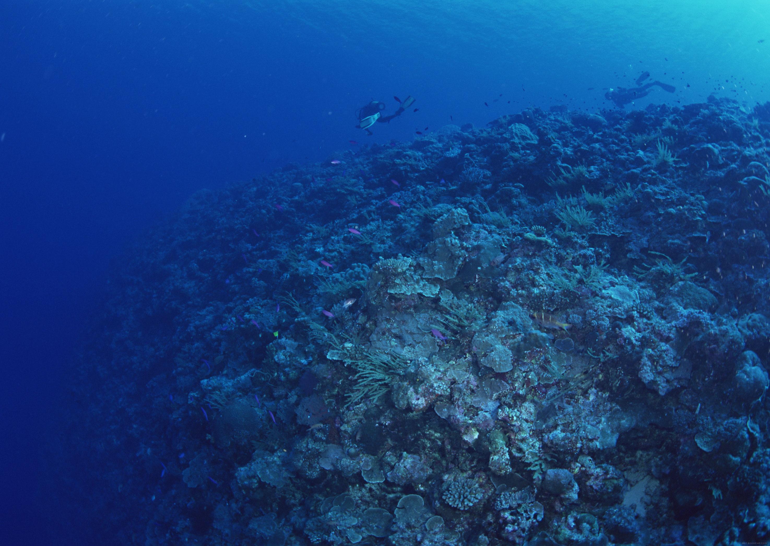
The discovery of deep sea coral forests in the spring of 2018 filled a significant gap in the benthos research and even in carbon cycling in the South China Sea. Previously, the researches of deep-sea benthos were restricted to the sediment-covered soft bottom due to the technical limitations, and the rocky hard bottom was believed to be barren of life. Using submersible technique in the mid-1990s, deep-water coral reefs were first discovered in the Atlantic Ocean, which opened a new research direction in marine sciences. Two groups of deep sea corals have been recognized: scleractinian hexacorals and gorgonian octocorals. The aragonite skeleton of the former group build up deep sea coral reefs, while the latter make up deep sea coral forests with high-Mg calcite skeleton in many gorgonian corals. All kinds of carbonate coral skeletons can record environment changes of the deep sea and provide excellent material for high-resolution paleoceanography. Although the development of deep sea coral reefs in the Pacific Ocean is hampered by its extremely shallow aragonite compensation depth, deep sea coral forests are ubiquitous in the ocean. Up to now, most parts of the Pacific have not yet explored in this respect, and deep sea corals remain outside the research scope. The present paper is a literature review and calls for attention to the deep sea forests. It starts with the composition and distribution of deep sea coral reefs and forests, followed by discussions on the significance of deep sea coral forests in marine ecology and in paleoceanographic reconstructions.
In global subduction systems, the subduction inputs include normal oceanic slabs and buoyant oceanic plateaus. Both exert different geological effects on subduction zones. Thus, studying the interactions among the oceanic plateau and subduction zone will be significant for understanding subduction zone geodynamics and the lateral accretion processes of the continental crust. This study summarizes the geological and geophysical characteristics of typical oceanic plateaus that are currently close to subduction zones. These, combined with the geological and geophysical features of adjacent subduction zones and recent numerical simulation data, are used to discuss the geological effects of the interaction between oceanic plateaus and subduction zones. In terms of kinematics and geometry, buoyant oceanic plateaus generally resist subduction, leading to subduction retreatment and the reversal of subduction polarity, thereby forming new subduction zones. The subduction process in some subduction zones is terminated by the arrival of oceanic plateaus, and the plateaus finally accrete to the mature arc/crustal margins and become part of the continental crust. However, recent studies have shown that part of the oceanic plateaus do not lead to the termination of the subduction process, but rather contribute to the occurrence of flat subduction, thereby resulting in tectonic shortening and the thickening of the overlying plate in the subduction zone area and the gradual migration of magmatic activity toward the intraplate setting. Geochemically, these oceanic plateaus with enriched compositions not only affect subduction zone lava geochemistry and the formation of hydrothermal deposits, but may also contribute to the formation of mantle heterogeneity. Finally, this study proposes some key scientific issues on the interaction of oceanic plateaus with subduction zones, including the detailed crust/mantle structure of subduction zones, the geological and geochemical response of the island arc and backarc basin to the new subduction tectonic framework of “oceanic plateau-trench,” and quantitative correlations between the factors controlling whether plateaus are accreted or subducted remain unclear.
Previous sequence stratigraphy research has mainly focused on two-dimensional seismic interpretation in the dipping direction, while variations in sequence architecture in the vertical provenance direction are the focus and difficulty of current research. This study considers the Late Pleistocene (0.125 Ma to the present) shelf-margin stratigraphic successions of the Qiongdongnan Basin as a typical example. The internal structure and combination characteristics of the system tract units were established and identified according to typical stratal termination, stratal stacking patterns, and shelf-edge migration trajectories. The systems tracts in the studied sequence were classified from bottom to top, including the Lowstand Systems Tract (LST), Transgressive Systems Tract (TST), Highstand Systems Tract (HST), and Falling-Stage Systems Tract (FSST). The surface of Within Systems Tract Surface (WSTS) divides the FSST into early and late phases. The WSTS interface is the transitional surface for the positive-to-negative angle of the migration trajectory of the shelf edge and for the stratal stacking transition from progradation to degradation. Stabilized and collapsed shelf-edge sequence architectures developed during the Upper Pleistocene in the western part of the eastern Qiongdongnan Basin. With the change in relative sea level, the stabilized shelf edge mainly developed multi-phase shelf-margin clinoforms and deep-water fan deposits, whereas the collapsed shelf edge mainly developed large-scale canyons and mass transport deposits. In response to the short sea-level rise but prominent falling cycle, the late Pleistocene shelf-edge sequences were composed of thin or undeveloped LST and TST units and a thick FSST unit, whereas the active faults in the outer shelf locations increased the proportion of the HST unit in the sequences. The pre-existing slope-break geomorphology, fault activities, and asymmetric sea-level fluctuations coevally led to the diverse sequence architectures in the study area. The quantitative exploration of high-frequency sequence stratigraphic driving mechanisms is a future development trend in Pleistocene stratigraphy, and this study provides a potential reference for the standardization of 3D sequence stratigraphic investigations.
Seafloor methane seepage is an important source of methane affecting the global carbon cycle and extreme environmental biogeochemical cycles. Therefore, identifying modern and ancient seafloor methane seepage is of great scientific significance. During methane leakage, Sulfate-Driven Anaerobic Oxidation of Methane (SD-AOM) commonly occurs, changing the geochemical characteristics of pore water and forming of authigenic minerals. Authigenic pyrite is a typical authigenic mineral in SD-AOM and can be used as a good indicator for recording methane leakage. This study summarizes the geochemical and morphological characteristics of SD-AOM-derived authigenic pyrite and evaluates its potential for tracing and reconstructing seabed (paleo) methane leakage. The results show that the sulfur and Fe isotopes, as well as in situ trace elements and isotopes of authigenic pyrite, can effectively identify the SD-AOM process. In addition, significant differences are observed in the morphology and content of authigenic pyrite in sediments in these environments compared with normal marine sediments, highlighting the great potential of authigenic pyrite for tracing and reconstructing seabed (paleo-) methane leakage events.
High sequestration efficiency and strong sequestration potential of land-sea interaction regions are important nature-based long-term solutions to climate change and the achievement of “carbon peak” and “carbon neutrality”. To reveal the sources and forms of Dissolved Organic Matter (DOM) in the land-sea interaction stratigraphy along the south coast of Laizhou Bay and enrich the understanding of carbon sources and sinks in the land-sea interaction region, interstitial water from a drill core was collected from November to December 2021 and analyzed for ultraviolet (UV-) visible absorption spectra and three-dimensional fluorescence spectral signatures of Chromophoric Dissolved Organic Matter (CDOM). The analyses showed that dissolved organic carbon and a(320) were both characterized by large and high concentrations after the second transgression. The differences in the DOM composition and properties of terrestrial-phase interstitial water were greater than those of marine-phase interstitial water. Excluding the bottom stratum, of the five fluorescence components identified by parallel factor analysis and matched using OpenFlour, humus-like components contributed 77% of the total fluorescence intensity. The fluorescence and biogenic indices showed that the core interstitial water chromophoric dissolved organic matter was dominated by the contribution of microbial reproduction activities; the longer the burial was, the more significant the microbial contribution, and there was no significant difference between the terrestrial and marine phases. The results of principal component analysis show that the compositions exhibit several differences in different sedimentary stages, but the composition and properties of the interstitial water DOM gradually converge as the sedimentary process occurs. Humus matures over long timescales.
Marine carbon storage plays a crucial role in reducing global greenhouse gas emissions. To ensure the efficient and safe storage of CO2, it is imperative to monitor the potential migration of CO2 before, during, and after injection. Current methods for monitoring marine carbon storage encompass built-in sensor monitoring focusing on the seabed wellbore, geophysical monitoring targeting reservoirs and caprocks, and marine environmental monitoring focusing on the seafloor and water column. These three methods can be used to obtain temperature/pressure/acoustic data near the injection/monitoring wellbore, seismic/electromagnetic/gravity data of deep reservoirs and caprocks, and acoustic/chemical/oceanographic data of near-bottom sedimentary layers and seawater, respectively. Analyzing these datasets is expected to reveal the migration characteristics of CO2 injected into the formation. However, the integrated use of relevant monitoring methods and technologies and the design of high-quality monitoring strategies currently pose significant challenges for both academic and engineering communities. To enable scientific and systematic monitoring of the safety of marine carbon storage, offering essential guidance for offshore storage operations, and concurrently enhancing monitoring efficiency while reducing monitoring costs, we have compiled the fundamental principles, application status, and challenges encountered by different monitoring methods and technologies. We also anticipate future development of monitoring technologies for marine carbon storage.
Benthic O2 uptake is a robust proxy for organic matter mineralization in marine sediments. Therefore, studying sediment oxygen consumption is conducive to understanding the global marine carbon cycle. Three approaches are commonly used to measure oxygen consumption at the SWI: oxygen microprofiling, benthic incubation, and the eddy covariance technique. The emerging eddy covariance technique is a non-invasive approach that can measure benthic O2 flux on a relatively large scale, and thus has wide application. Globally, benthic oxygen consumption is controlled by water depth and primary productivity in surface water. In addition, benthic diffusive oxygen uptake and total oxygen uptake decreased significantly and their ratios approached 1 with increasing water depth. This was mainly caused by the substantial decrease in benthic biomass and resulting benthic oxygen consumption with increasing water depth. Despite more than half a century of observations of benthic oxygen consumption, in-situ data remain scarce, especially in deep-sea and extreme marine environments. A large amount of measured data are still single-point observations within a short time period. Against the background of global warming and the increasing impact of human activities on marine environments and ecosystems, it is necessary to conduct high-precision and long-term in situ observations of benthic oxygen consumption globally.
High-resolution geophysical data indicate that there are numerous submarine landslides in the China Sea region at various scales, particularly on continental slopes. Potentially devastating tsunami hazards generated by submarine landslides pose a great threat to the populous coastal region, fisheries, and oil and gas exploitation in the deep sea. Thus, hazard assessment is necessary. This study investigates the potential tsunami hazards generated by four representative submarine landslides in the South China Sea (SCS). The geological background and triggers of these submarine landslides are summarized. The key parameters of each landslide were constrained by currently available geological and geophysical data. A combined modeling approach, NHWAVE and FUNWAVE-TVD, was used to model the dynamic process of landslide movement and the generation and propagation of landslide tsunamis. The simulation results show that the tsunamigenic capacities of the Baiyun and Zengmu Ansha Slides differ significantly, although they have comparable volumes. This large difference was attributed to the discrepancy in the initial water depth and slope gradient. Tsunami waves generated by the Baiyun Slide rose up to approximately 12 m in the source area and mainly affected the northern region of the SCS, particularly the southern mainland Chinese coast. The Zengmu Ansha Slide generated 38 m tsunami waves that assailed the majority of the coastline of the southern SCS. The Zhongjiannan Slide generated highly localized tsunami waves about 10 m near the source region on the west SCS coast. The North Xisha trough slide produced a minor tsunami impact with tsunami waves that were approximately 0.9 m high in the source region. The distribution of the maximum surface elevation and the propagation characteristics of tsunami waves suggest that the tsunamigenic potential of submarine landslides is controlled by geometric and kinematic parameters. Meanwhile, complex bathymetry and coastlines change the energy distribution of tsunami waves, increasing the difficulty of tsunami hazard assessment. Conducting landslide-tsunami simulations for typical landslides in the SCS and establishing a landslide-tsunami database is of great research significance and will assist in improving the prediction of marine geo-hazards in China.
The dynamics of the deep-sea Bottom Boundary Layer (BBL) directly control the deep-sea sedimentation process, making it the most important energy and material exchange layer in deep-sea science. According to existing sporadic observations, BBL dynamics controlled by multi-scale motions in the ocean differ greatly from current theories, and there remains a lack of systematic quantitative studies on the deep-sea sedimentation process influenced by BBL dynamics. Based on the theoretical framework, sporadic in-situ observations, and numerical and laboratory research, the following points are reviewed and summarized herein: ① Basic characteristics of BBL flow and its turbulent characteristics; ② Effects of tides, internal waves, mesoscale eddies, and large-scale circulation on the BBL dynamics in the deep sea. This review provides a background for further research on deep-sea sediment dynamics based on observations of BBL dynamic processes.
Underwater cultural heritage is closely related to the development of history, art, economy, and science. Buried shipwrecks are an important type of underwater cultural heritage that must be considered in the future exploration of underwater cultural relic sites in China. Marine geophysical methods play an important role in the exploration of these sites. Based on research on the application of marine geophysical acoustic detection methods in buried shipwrecks, the characteristics of reflection coefficient and polarity change between buried shipwrecks and the surrounding environment was analyzed, and the application and progress of marine geophysical acoustic detection in the identification of buried shipwrecks, degradation degree evaluation of buried shipwrecks, and 3D reconstruction of buried shipwrecks remains was discussed. The detection and research of buried shipwrecks in China needs to be strengthened in terms of controllable experimental simulation, fine data processing, and interdisciplinary comprehensive research to satisfactorily detect buried shipwrecks.
Image sampling of megafauna using a towed camera is immensely beneficial in deep-sea biological investigations because of the benefits of a wide investigation range, long duration, and no risk of specimen destruction. However, its automatic identification and error analysis are still understudied. A deep-sea megafauna body size measurement method was developed using towed camera observation photographs from the COMRA 50th cruise. We successfully obtained body size information of 12 sea cucumbers in the Pacific Ocean and observed a green giant sea cucumber 70.8 cm long. We examined the towed-camera system, installation, and observation errors, which imply that nonparallel lasers cause the most significant errors. A technique for correcting the inaccuracy caused by the swing of the towed camera was developed. Based on the above results, it is beneficial to logically develop the technical requirements for the examination of deep-sea megafauna with a towed camera and to encourage extensive investigation of deep-sea benthic megafauna.
Magnetism is probably one of key disciplines for breakthrough of paleoenvironment studies in abyssal plain of the South China Sea. Magnetic susceptibility is the most basic and general parameter reflecting information of magnetic minerals in sediment, while ARM is sensitive to the concentration of singe domain particles which is main carrier of remanent magnetization. In this study, we explore the geological implications of magnetic susceptibility and Anhysteretic Remanent Magnetization (ARM) in core QD189 retrieved from abyssal plain of the South China Sea integrating the data of grain size and clastic mineral abundance. In the segments with magnetic susceptibility great than 45×10-5 or the segments with depth less than 481 cm and magnetic susceptibility less than 45×10-5, there are similar fluctuations among magnetic susceptibility, the contents of 2~5 ϕ grain size range, ARM, and ARM@20mT , and the magnetic susceptibility changes in these segments is probably due to the fluctuations of contents of the soft magnetic multidomain grains within 2~5 ϕ grain size range. In the segments with depth from 808 cm to 488 cm and magnetic susceptibility less than 45×10-5, the coherences among the changes of magnetic susceptibility, the contents of 2~5 ϕ grain size range, ARM, and ARM@20mT are poor, and the mechanism of magnetic susceptibility changes is pending further research. 2~5 ϕ grain size range is an important coarse grain size component in QD189, and generally have a higher contents and bigger change ranges below the depth of 350 cm than above the depth of 350 cm. ARM@20mT can more accurately indicate the concentration of singe domain particles in QD189 than ARM, and except single-domain particles, the particles of the pseudo-single-domain and multidomain within 9~12 ϕ grain size range probably make some indispensablet contributions to ARM in the segment with 665~48 cm depth, and a part of ARM in segment with 548~310 cm depth is also derived from multidomain within 6~9 ϕ grain size range. Six volcanic actions are recognized by the corresponds among the extreme peak values of clastic mineral abundance, volcanic glass abundance and magnetic susceptibility. The distribution pattern of volcanic glass abundance reveals the prevalence of bioturbation in QD189.
This paper discusses some major research to be carried out in the next five years in the newly established Laboratory of Ocean Lithosphere and Mantle Geodynamics. By using our existing sample collections of global mid-ocean ridge basalts, gabbros and abyssal peridotites from the Pacific, Atlantic and Indian oceans, the research includes: ①Using Ti-Zr-Hf stable isotope methods to test the hypothesis that the observed huge Nb-Ta and Zr-Hf fractionations result from mass-dependent fractionation under mantle magmatic conditions; ②Using a MORB sample suite of uniform ratios of incompatible elements and Sr-Nd-Pb isotopes with large major element compositional variation to test the common hypothesis of iron isotope fractionation, i.e, the affinity of heavy Fe with ferric Fe (Fe3+), and both heavy Fe and ferric Fe (Fe3+) being more incompatible than light Fe and ferrous Fe (Fe2+) during magma evolution; while using an incompatible trace element and Sr-Nd-Pb isotope highly variable MORB suite to test the same hypothesis during low-degree mantle melting (i.e, the effect of mantle metasomatism); ③Proposing and testing the hypothesis that the high oxygen fugacity of the Earth’s mantle is a consequence of plate tectonics by subducting partially serpentinized oceanic mantle lithosphere with abundant ferric Fe (e.g. Fe3+/SFe>2); ④The recent work by Andersen et al. (Nature, 2015) is a milestone contribution by using U isotope variation in oceanic basalts to hypothesize that the O2-rich atmosphere since the late Archean (abont 2.4 Ga) mobilized the water soluble U (6+ vs. 4+) from continents, transported to the ocean and subducted with sediments to the upper mantle, which explains the low Th/U in MORB (<2.5) and the high Th/U (>3.5) ocean island basalts (OIB) do not see such U addition effect probably because OIB source materials are all ancient (> abont 2.4 Ga) if there were subducted component. The Cenozoic alkali basalts from eastern China are ideal materials for evaluating the significance of the subducted seafloor materials for the petrogenesis of OIB and enriched MORB by using the U isotope approach, which is expected to revise and improve the Andersen et al hypothesis.
Deep-sea is one of the most important extreme environments on the earth. Numerous and diverse extremophiles thrive in this extreme environment, presenting distinctive physiological structure, metabolic mechanism and symbiosis relations, which provide new methods to study the origin of life and extraterrestrial life. Despite extensive studies on deep-sea extremophiles from the point of view of biology, the impacts of deep-sea hydrothermal activity on the evolution of extremophiles remain largely unknown. On the basis of summarizing features of the deep-sea ziphysicochemical and geological environment, the distribution and formation mechanism of submarine hydrothermal vents were analyzed, respectively. Hydrothermal vents have great effect on the distribution and succession of communities. Our discussion focused on the extreme life forms of microorganisms surviving in the hydrothermal ecosystem and their important significance for the nutrient cycling and ecosystem evolution. However, the research of life processes in extreme environments is still in the primary stage and more work is needed on the in-situ detection technique, molecular biology and interdisciplinary research.
Marine geophysical acoustic methods are a powerful tool for high-precision, large-scale underwater archaeological relics investigations and research in the shallow water. There is a complex coupling relationship between the marine environment and the preservation of underwater cultural relics, which leads to great uncertainty based on the detection data to deduce the existence and distribution of underwater cultural relics. In the past 30 years, the controllable experiments of acoustic methods for underwater cultural relics show that different side-scan sonar systems have varied acoustic response. Multi-beam sonar can be used to study the temporal variation of underwater cultural relics, while shipwreck partially or totally embedded in seabed sediments can be detected by sub-bottom profile. The control experiment will increase the understanding of the acoustic response for different underwater cultural types. Control experiment on the underwater cultural relics can provide a reference for the correlation between detection results and interpretation accuracy, and hopefully provide a systematic solution for underwater cultural survey in an efficient way and on a wide-scale, thus better protecting and managing underwater cultural relics.
Submarine canyons represent one of the most important geomorphologic features in continental margins, act as one of the most important conduits of seafloor sediment transporting from shallow waters into the deep sea, and are also biodiversity hotspots. Submarine-canyon investigations are therefore significant for seafloor scientific research, submarine mineral and resource exploitation, and the construction and safety operation of submarine infrastructures. Deep-sea diving by manned submersibles and robot submersibles represented by Remotely Operated Vehicles (ROV) and Autonomous Underwater Vehicles (AUV) provides an important approach to the investigation of modern submarine canyons. The biggest advantage of manned submersibles is that they can bring scientists to the deep sea for in-place observations and precise sampling, while the robot deep-sea diving has the advantages of low cost, high efficiency, no personnel safety concerns, and the ability to reach the extreme sea areas that are difficult for humans to reach. Deep-sea diving has found broad applications in the geo-scientific research of submarine canyons. These studies cover seafloor topography and geomorphology, seafloor sediments, erosional and depositional bedforms, mass transport processes and flow dynamics, cold springs, cold-water corals and other biological habitats, as well as seafloor biological erosion. The research experience and scientific findings in scientific diving investigation of submarine canyons accumulated by the developed countries in Europe and the United States over the past 70 years are of great reference and significance to the emerging scientific deep-sea diving in China.
Revealing the controlling effect of geological structure on seafloor hydrothermal activities is of great significance in understanding the formation mechanism of hydrothermal system and searching for seafloor sulfide resources. This article summarized the topography and faults, crustal structure, gravity and magnetic field, heat flow and magmatism in the middle and southern Okinawa Trough, as well as the general characteristics of hydrothermal field distributions and hydrothermal products. By comparing the Okinawa Trough with the Manus Basin, Mariana Trough, North Fiji Basin and Lau Basin with different rock basements and extension stages, we generalized some specific geological characteristics of the Okinawa Trough, including the transitional crustal nature, low extension degree, high heat flow value, extremely thick sediments, and bimodal volcanism. The hydrothermal activities in the Okinawa Trough are controlled by fault structures, magmatism, and spreading rate, and at the same time, are affected by basement rock types and sediment covers. In the middle and southern parts of the trough, two group of faults that are parallel and perpendicular to the strike of the back-arc basin promote the fluid circulation, and large-scale magmatic activity provides sufficient heat for the hydrothermal system. In addition, the interaction of fluids with the widespread silicic volcanic rocks and thick sediments leads to the enrichment of organic matter, CO 2, and metals such as Ag and Au in the hydrothermal products. According to the extension rate and geological features of the Okinawa Trough, we believe that the Okinawa Trough has potential to have new hydrothermal fields discovered and we speculate that new hydrothermal fields most possibly exist in the regions influenced by ridge subduction as well as the neo-volcanic zones closed to the island arc.
Since 1990s, spectral analysis has become an important technique to characterize the properties of chromophoric and fluorescent dissolved organic matter (CDOM and FDOM) from various aquatic systems and a series of spectral indices have been suggested to trace the sources of DOM and their biogeochemical regulation processes. DOM samples were collected from an aquatic continuum from watershed to deep ocean, i.e. Zhangjiang River and Estuary, Dongshan Bay, Taiwan Strait, Northeast basin of the South China Sea, Luzon Strait and the vertical profile of the Kuroshio region of the West Pacific Ocean. This continuum covered many critical interfaces (land-ocean, shelf-basin, marginal sea basin-open ocean and euphotic and aphotic layer). The spatial distribution and variation of various qualitative and quantitative parameters along the continuum were clearly revealed. Combined with literature review, the sources and sinks of CDOM/FDOM and their inherent regulation processes under significant hydrological and biogeochemical gradient variation were systematically summarized. The geochemical differentiation of the quantitative DOM spectral index in various aquatic systems was discussed. The tracing ability of the qualitative DOM spectral index was commented. The coupling study of soil-river organic matter systems, mechanism of mineralization-related microbial production of CDOM/FDOM, quantified geochemical framework concept and perturbation of global change on CDOM/FDOM dynamics were suggested as future key topics.
Cyclic steps structure derived from the supercritical flows is one of the common bedforms, which is commonly found in sedimentary systems such as delta systems, deep-water canyon-channel systems, and carbonate platforms. In this paper, the research progresses of cyclic steps were introduced from the aspects of sedimentary environment, the features of bedforms, sedimentary structure, formation mechanism, and numerical simulation. The Research scale differences associated with the survey techniques or study methods, such as the ship survey and AUV-based multi-beams, sub-bottom profiles, multichannel seismic, the field outcrop, and numerical simulation were discussed. Finally, the breakthrough directions of the cyclic steps research were given. The combining method of ground penetrating radar, multichannel seismic, drilling and well logging were used to accurately detect the location of field outcrop thalweg. Within the area with water depth greater than 500 meters, the blending of multi-data for the cyclic steps research involved the AUV-based and the ship multi-beams, sub-bottom profiles, and multichannel seismic data. With the in situ samples and observation data obtained by human occupied vehicles, three-dimensional numerical simulation was developed to establish a set of dynamic simulation equations suitable for the real cyclic steps. Therefore, the high resolution three dimensional mode of the deep-water cyclic steps could be obtained more accurately.
Since the Neogene, reef carbonate has been widely distributed in the Andaman Sea under the tectonic background of the continental margin and volcanic basement uplift. To better understand the tectonic evolution and paleo-environmental characteristics of the Andaman Sea, the platform margin stratigraphy was divided into five seismic sequences through high-resolution seismic profiles. Based on the established seismic sequence framework, the evolution model and development controlling factors of regional Miocene biogenetic reefs are discussed. The research shows that the growth, development, and spatial distribution of reefs in the eastern Andaman Sea are mainly controlled by the formed topography and sea-level changes. During the Miocene, the Andaman Sea experienced a rift during the back-arc strike-slip stage, accompanied by an increase in sea level. The topography of the high east and low west caused by the southern Sagaing Fault provides a favorable place for the development of reef carbonate in the eastern terraces. The secondary fault caused the east-west division of the reef, while the steady rise in sea level caused the reef to grow steadily.
The North Irian Basin is located at the convergence and compression edges of the Australian and Pacific plates. Since the Late Cretaceous, the Australian Plate has been moving northward, and collision with the Pacific Plate has occurred several times, forming a complex area of tectonic activity. This provides a foundation for the formation of extensive landslides on the seafloor in the northern margin of the basin. By analyzing the high precision 2D seismic data in the north of the basin, the characteristics of submarine landslides are described in detail. Three structural units of a submarine landslide, namely the headwall domain, translation domain, and toe domain, are identified, which have their typical seismic characteristics. Submarine landslides are widespread in this area and can be divided into four types: continental slope/shelf, channel wall, valley, and Mass Transport Deposits (MTDs). Combined with the regional geological background of the basin, it is considered that the tectonic movement of subduction and collision between plates plays a major role in controlling submarine landslides, which is induced by the combined action of external factors such as the submarine terrain slope as the internal cause, the sediment supply rate, sea-level change, and seismic activity.
The Tanimbar Trough is located southeast of the Banda Arc in Indonesia, and is connected with the Timor and Aru troughs, which were formed during the collision between the Australian continent and Banda Arc. During the arc-continent collision, the track, age, and mode of collision remain controversial. It is also controversial whether the Tanimbar Trough is a subduction zone. Based on the 2D seismic lines, the growth index, and the paleo-fall method, the faults in the study area were quantitatively analyzed. Combined with logging and provenance studies, the fault characteristics and tectonic evolution of the Tanimbar Trough are discussed. The results show that the fault activity in the study area was active during the Cretaceous and Early Pliocene, which coincided with the period of tectonic activity. Mesozoic rifting formed normal Mesozoic faults, and the Australian Plate collided with the Banda Arc in the early Pliocene. The arc-land collision led to the uplift of Tanimbar Island and the subsidence of the Tanimbar Trough and triggered the reactivation of Mesozoic faults. The deformation of the trough continued until the Late Pliocene, forming the Tanimbar Trough.
The Timor Trough is located at the boundary of the Eurasian and the Australian plates, in the outer Banda Arc between the Banda Sea in Southeast Asia and the Timor Sea in northwest Australia. Since the Neogene, especially from the Late Miocene to the Late Pliocene, the collision between the Australian continent and the Banda Arc caused the uplift of Timor Island and the deformation of the Timor Trough, which affected the regional tectonic activities. A series of normal faults developed at the margin of the Australian Northwest shelf, which mainly controls the platform, horst, and graben features. The northern Timor Trough formed a series of thrust faults under the dual effect of the uplift of Timor Island and subsidence of the Timor Trough caused by arc continental collision. The NE-SW thrust fault at the bottom of the Timor Trough is the deformation front that controls the shape of the trough. The characteristics of tectonics and earthquakes indicate that the Banda subduction zone between the Australian Plate and Banda Arc is located in the Ombai Strait, which is between Timor Island and the inner Banda Arc, subducting at an average high angle of approximately 62° at a depth of more than 600 km. The subduction angle in the south is larger than that in the north, which is related to the compression of the Indian Ocean subduction plate. The front oceanic crust subducted below the northwest Banda Sea showed a horizontal trend below 500 km. There is an obvious discontinuity in the earthquakes between the deep and upper focus zones. The subduction of the Australian Plate beneath the Southeast Asian Plate may have gradually slowed down and stopped; however, the deformation of Timor Island and the Timor Trough caused by arc continental collision continues. The inner Banda Arc is deforming along the Banda Sea. Under the background of relatively balanced subduction, the subduction of the Australian Plate beneath the Southeast Asian Plate may have transformed into an orogeny. In the future, the inner Banda Arc may be uplifted to form an inner and outer Banda Arc double orogenic belt.
Deep-sea corals live in the dark cold-water environments, the food of which that provides them with energy and nutrition is a key ecological and biogeochemical problem. Currently, the most common understanding is that their food mainly comes from organic matter produced by and deposited from surface seawater. However, more and more studies have found that they can also obtain food supply through symbiosis with a variety of chemosynthetic autotrophs and heterotrophs. Carbon and nitrogen isotopes have been used to trace and reveal the food sources of deep-sea corals. They also have been successfully used to reconstruct the phytoplankton community structure and the changes of nitrate isotopes in surface seawater in the past, thus providing valuable biogeochemical data for paleoceanographic study. However, due to the widespread existence of symbiosis with chemosynthetic autotrophs, further studies are needed to assess the reliability of organic carbon and nitrogen isotopes of deep-sea corals to reflect changes in the surface seawater. The deep-sea gorgonian coral, like those gorgonian forests recently found in the South China Sea, is relatively new and insufficiently studied in the field of deep-sea corals. Thus, basic biochemical and paleoceanographic researches on the South China Sea deep-water gorgonians will provide profound and novel insights to understanding the cold-water coral system.
Establishing a precise chorology is a critical issue when employing cold-water coral as paleoenvironmental archives. Currently, U-Th, 14C and 210Pb dating techniques are the most frequently used methods. The high-magnesium calcite skeleton of bamboo coral has clear growth bands, which is appropriate for 14C and 210Pb dating methods and holds a great potential to be high-resolution archives of mid-to-deep ocean evolution. Aragonitic stony coral is appropriate for both U-Th and 14C dating methods, which is valuable in paleoceanographic research. Because the U-Th method can provide the absolute chronology of coral samples, it can further be used to calculate the 14C age of ocean carbon reservoirs. Therefore, U-Th and 14C dating results of stony coral are currently the most reliable data for exploring the evolution of ocean carbon reservoirs through the Last Glacial Maximum to the present. It has been found that the 14C ventilation ages of intermediate water masses of the equatorial Atlantic and Southern Ocean significantly decreased at the end of the Heinrich Stadial 1. This suggests a massive carbon transfer from deep oceans to the atmosphere, or the Atlantic intermediate depths were ventilated by the southern- and the northern-sourced water masses, respectively, before and after the Heinrich Stadial 1.
Cold-water corals represent an intriguing paleoceanographic archive with a great potential to reconstruct high-resolution paleoenvironmental changes. Compared to those of shallow-water corals, proxies derived from cold-water corals have been complicated by biologically mediated vital effects. The oxygen and carbon stable isotope compositions of cold-water coral skeletons are more depleted than the expected carbonate-seawater equilibrium values by 4‰~6‰ and about 10‰, respectively. Therefore, it is necessary to correct for the vital effects before using δ18O as a temperature proxy. The principles and methods of reconstructing paleotemperature variations of intermediate and deep oceans using oxygen and carbon isotopes of cold-water corals are reviewed, as well as three existing cold-water coral calcification models and their advantages and disadvantages. It is suggested that further micro-scales analysis and targeted experiments are required to clarify the calcification processes of cold-water corals.
The cold-water bamboo coral, dwelling in the depths of global seas, is characterized by the “bamboo-like” skeletal structure of alternating calcite internodes and gorgonin nodes, and has “tree-ring-like” concentric growth rings transversally. Paleoceanograhic reconstructions using bamboo coals would fill the geographic and temporal gaps of traditional means. In this work, the inorganic geochemical proxy methods for bamboo coral are introduced, including Mg/Ca for ambient temperature, Ba/Ca for seawater nutrient content, and δ11B for seawater pH. Also, the potential influences of vital effect on the proxy reconstructions are briefly discussed. With the recent findings of deep-sea bamboo coral forests in the western Pacific region, a new territory of bamboo coral paleoceanography is opened for the scientists from the nearby countries.
At the IODP Forum 2017 in Shanghai, IODP-China proposed initiating the discussions on “IODP beyond 2023”, and the meeting supported China’s proposal to host and co-lead the activities for preparing the science plan of ocean drilling after 2023. The present paper started from an overview of the planning processes of ocean drilling science over the past decades, then analysed the scientific targets and perspectives of the future ocean drilling, and concluded with suggestions about how China should prepare the international discussions on “IODP beyond 2023”.Since half a century, the ocean drilling has played a role of locomotive in international Earth science community and of flagship in deep-sea research.China’s initiation and co-leadership in preparing its science plan for the next decade will promote the upgrading of Earth science in our country, yet the success of the endeavor heavily depends on active involvement of the scientific community , especially on its contribution with creative thinking.
The Antarctic and the Arctic regions play a key role in global sea level change and carbon cycle, and reserve key information of the Cenozoic transition from a green-house to an ice-house Earth. They have become hot spots in earth science studies. The geological drilling projects in both polar regions (e.g., DSDP/ODP/IODP/ICDP) have achieved remarkable successes, which have freshened the knowledge of global environmental and climatic evolution. Along with the Cenozoic global cooling, the timing of glaciation was almost synchronous on both the Antarctic and the Arctic. Accompanied with the Antarctic ice sheet build-up and increased terrestrial weathering, the enhanced formation of Antarctic Bottom Water exerts significant impact on global ocean circulation. The volume of unstable West Antarctic Ice Sheet fluctuates during glacial-interglacial periods showing 40 ka obliquity cycles, its volume significantly reduced or collapsed during several peak interglacials or long warm intervals. The Southern Ocean plays a significant role modulating atmospheric CO2 concentration, global deep water circulation and nutrient distribution, productivity at different time scales. Sea level responses to the waxing and waning of polar ice sheets at different time intervals were tested, which provide valuable clue for predicting future sea level changes. The upcoming IODP drilling projects on polar regions will keep focusing on the high latitude ice sheet development, Southern Ocean paleoceanographic evolution, land-ocean linkages in the Arctic, and the impacts on the global climate, which will provide important boundary conditions for predicting global future climate evolution.
Knowledge of ocean crust is one of bases to understand the deep and the surface of our planet. Since the definition of the Earth crust based on the geophysical discovery of Moho, marvelous efforts have been made to understand the geological significance of the Moho and the structure of the ocean crust. Up to date, it becomes clear that the Penrose model built up on ophiolite is unsuitable for the explanation of the ocean crust structure along slow and ultraslow spreading ridges, and probably also questionable for that of fast spreading ridges. The only effective way to solve the problem is to drill into the geophysical detected Moho and get samples. With the development of modern technology and more logic scientific strategy, that largely improved from the milestone Mohole projects carried out about half a century ago. The time to realize the Mohole dream seams coming.
Subduction zones are one of the most critical types of plate boundary of the Earth system, crucial for the global geochemical recycling of the Earth system, genesis of island arc and continental crust, and mechanisms of earthquake and tsunami processes. Ocean drilling plays an essential role in advancing our understanding of the subduction processes. This paper highlights the recent progress and scientific goals of the international ocean drilling programs in subduction systems and discusses implications for strategic planning of the future ocean drilling initiatives.
Aiming at the current climate status, i.e., drastic rise of atmospheric greenhouse gases and the apparent trend of global warming, the International Ocean Discovery Program (IODP), launched in 2013, proposed four scientific challenges, including the response of global climate to CO2 rise, the feedback of ice-sheet and sea-level to global warming, the dynamics of the mid- and low-latitude hydro-cycle, and the mechanism of the marine carbon-chemical buffering system. By August 2017, eight IODP expeditions of climate-related themes were implemented, focusing on the Neogene evolution of the monsoon system over Asia-Pacific-Indian and the West Pacific Warm Pool, with specific interests in the variabilities and mechanisms of the Asian Monsoon system on orbital-to millennial-scales, as well as the connections between Asian Monsoon and the uplift/weathering of the Tibetan Plateau on tectonic time scale. The planned IODP expeditions in the forthcoming two years will explore the Southern high-latitude climate histories of West Antarctic ice in the Cenozoic, and Southern Ocean currents and carbon cycle in the Cretaceous-Paleogene. In sum, during the current phase of IODP (2013-2023), our knowledge about the marine climate system would be greatly advanced via deciphering the past changes in tropical processes of Asian Monsoon and West Pacific Warm Pool, as well as in high-latitude factors of the West Antarctic ice. A better scientific background of natural variability would be provided, accordingly, for predicting the future tendency in climate change. In this context, China’s strategic directions include the global monsoon concept, the tropical forcing hypothesis, and in particular the climate effect of the Sunda Shelf.
The discovery of living microorganisms deep in the marine sediments and even in the oceanic crust (the marine “deep biosphere”), is one of the most significant and exciting discoveries since the ocean drilling program began almost a half-century ago. Investigation of the deep biosphere has become the most thrilling research frontier for both geological and biological sciences. The “biosphere frontiers” has been listed as one of the four themes in the 10-year plan of the International Ocean Discovery Program (IODP 2012-2023), including deep life, biodiversity and environmental forcing of ecosystems. Here, we introduced the deep biosphere and its environmental features, several completed Integrated Ocean Drilling Program Expeditions, which targeted the subseafloor deep biosphere within the crust and sediments, and highlighted the main progress we have made in deep biosphere and deep life research, especially the contribution of Chinese scientists. Finally, we will give a perspective on the future of deep biosphere research according to the challenge we are facing and the key questions need to be answered.
Contourite is one of the most important type of sediments in the global ocean, which has recorded significant information on paleoclimatic changes. It is also of great importance for ocean engineering and marine hydrocarbon exploration. The development of scientific ocean drilling, especially the “Integrated Ocean Drilling Program” and the undergoing “International Ocean Discovery Program”, has made great contribution in mapping the spatial distribution of contourites and revealing contourite-related paleoclimatic information, through coring and geophysical exploration in the global ocean. It is found that the global distribution of contourites is controlled predominantly by the global deep-water circulation while its distribution in a specific region can be affected by the intensity of deep currents, tectonic activities, sediment supply, and so on. The geological changes in the global deep-water circulation is, however, further affected by tectonic activities, origins of water masses, as well as climate changes, e.g. the Cenozoic global cooling, changes in the size of the northern hemisphere ice caps, and intensity of monsoon. The main controlling factors of deep water circulation vary with different regions.
In the past 50 years, we have witnessed remarkable progress in our understanding of the Earth and ocean system, as a result of the internationally integrated deep ocean drilling programs, the Deep Sea Drilling Program (DSDP), the Ocean Drilling Program (ODP), and the Integrated Ocean Drilling Program (IODP). One of the legacies of the deep ocean drilling programs is the development and applications of the CORK, Circulation Obviation Retrofit Kit. Earth and ocean sciences have been shifting from a traditional discontinuous, expeditionary mode toward a mode of sustained in situ observations today. The seafloor CORK observatories offer Earth, ocean and life scientists new opportunities to study multiple, interrelated deep marine subsurface processes, over time scales ranging from seconds to decades. Here, we first provided a concise examination of the development history of the CORKs, then described the first installations of ODP CORKs, the evolution of different models of CORK, and finally, summarized the scientific lessons learned in the installation and operation effort of the CORKs. In the end, we offered our perspectives on using CORKs to study geological, hydrogeological, microbiological, and biogeochemical processes in the deep marine subsurface biosphere, particularly pertaining to China’s efforts in establishing and enhancing its deep-sea and deep-biosphere research and monitoring programs.
Oceanic red beds are widely distributed in the global oceans and across the entire Phanerozoic period, which mostly appeared after oceanic anoxic events. They represent typical oxygen-rich sedimentary environment and play a significant role on ocean science research. Numerous studies have been carried out since the oceanic red beds were discovered. However, previous studies mainly focused on the Cretaceous oceanic red beds, and the understanding of the characteristics and scientific significance of oceanic red beds are not comprehensive. Therefore, we here summarized the global distribution characteristics and compared mineral and element compositions of various lithological oceanic red beds, including marly, clayey and cherty oceanic red beds. The main mineral and element components of oceanic red beds have no direct relationship with the color of the sediments, and mainly are affected by the regional environment and provenances. Therefore, the mineralogical and geochemical characteristics of oceanic red beds should be analyzed in combination with the regional background. The red coloration of oceanic red beds is controlled mainly by hematite, goethite and manganese-bearing calcite, which have two main mechanisms: ① Colored minerals formed in oxic conditions; ② Colored minerals formed due to low deposition rates. These two mechanisms are not completely independent, but complement one another with either dominance in most oceanic red beds. Lithological characteristics of oceanic red beds are controlled by three factors, including water depth, productivity and nutrients. Therefore, the formation of oceanic red beds should be considered with global changes and regional events. The unique origin mechanism and global distribution characteristics of long time-scale oceanic red beds can be used to indicate sedimentary paleoenvironment, paleo-oceanic current, and paleoclimate change. In addition, hydrothermal or magmatic activities on the ocean floor could also produce red-color deposits that are strongly different from sedimentary oceanic red beds. Based on the existing research, we also put forward the future in-depth studies on the oceanic red beds from multidisciplinary perspectives.
A crucial and debatable issue in paleoclimatology is the change of terrestrial vegetation and the role of its carbon storage in glacial cycles. In the modern world, the Amazon Basin hosts the largest tropical rainforest and plays a major role of carbon sink, but during the glacial times another large tropical rainforest must have formed in the then emerged Sunda Shelf, SE Asia, and significantly changed the global carbon cycling. Accordingly, ocean drilling expeditions to the Sunda Shelf are being proposed in order to investigate the sea level changes, evolution of river network, vegetation and carbon storage, as well as biogeography of the tropical region over the last millions of years.
The sea level change is an important part of global change. It not only relates to the natural environment and ecological changes, but also has a significant impact on the economy and the development of human society. Understanding the sea level history and dynamic rule is a basic condition to build reliable models and improve the future forecast. Sunda Shelf is located between the Pacific Ocean and India Ocean. Owing to the feature of the second continental shelf area, wide shelf and gentle slope, Sunda Shelf is sensitive to sea-level change and an ideal place for sea level study. In this paper, we introduced the method of sea level reconstruction briefly, and reviewed the researches in the Sunda Shelf of different geological periods: Overall, the sea level in Sunda Shelf during Pliocene was as high as 50~100 m, then fell gradually along with the development of the polar ice sheets, and fluctuated among 130 m with the ice volume shrinking and growing in Quaternary. Holocene researches with the most records exhibited the fast elevating in the last deglaciation and the mid-Holocene highstand. Recent observations showed a rising trend of sea-level of past 200 years and the accelerating rate since twentieth century. Meanwhile, the divergence conclusions because of the various research method and regions indicated the complex of the influencing factors and the variability of the spatial and temporal distribution for the sea level reconstruction.
The Sunda Shelf, owing to its unique geographical location and roles, has attracted much attention on its changes during the glacial cycle. At present, there is a consensus about the change of temperature in the region, but the reconstruction of paleo precipitation has been disputed. The hydrogen and oxygen isotope records since the last glacial in the Sunda Shelf were collected, combining with other paleo climate record, we roughly divided the precipitation records in the region into the Northern and Southern areas. During the glacial, the precipitation changed little and climate remained moist in the northern area, while precipitation decreased greatly,and the climate became dry in the southern. Difference in the precipitation isotopes between the northern and southern areas might be related to the different controlling factors of the precipitation isotopes in the two areas and large-scale atmospheric circulation in the region. Limited by the collected hydrogen and oxygen records, the precise mechanism of division in regional hydrological changes of the region still needs more work to confirm.
To date, it is still heatedly debated that whether the exposed Sunda Shelf was covered by savanna or rainforest in the Last Glacial Period (LGP). A lot of palynological evidences revealed that large increase of non-arboreal pollen did not occurred on the southern South China Sea (SCS), and lowland and montane rainforest pollen were still predominant. Most of the herb-predominated pollen records occurred on the northern Australia, possibly indicating dispersions of herbs from current distribution centers. As a result, we advocated that inland and connected exposed Sunda Shelf around the southern SCS were covered by tropical forests rather than savanna during the LGP, although climate was drier then. This conclusion is not only supported by palaeoclimate-vegetation modeling, but also corresponds with most of the palynological evidences from South America. Current palynological records also showed the lack of palaeoenviromental reconstruction in Southeast Asia, including less pollen records and ambiguous correlations between marine pollen assemblage and its catchment vegetation.