


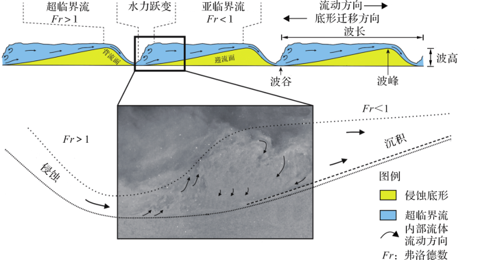
近些年,超临界流逐渐引起人们的关注,在海底上形成一系列的沉积波。在沉积波中,有一些呈向上游迁移的、长波状(波长/波高大于1)、一系列连续的陡峭背流面和平缓迎流面组合,并且经常在背流面与迎流面转换区域形成冲沟或深坑。这种沉积波代表流动状态从超临界流到亚临界流转换的一个过程,称之为“周期阶坎(cyclic steps)
图1
在海底峡谷、水道、深水沉积扇、河口三角洲和碳酸盐台地斜坡等沉积环境中均发育超临界流,控制流经区域的海底底形特征[6~9],对于“源—汇”系统研究具有指导意义。通过多波束、浅剖、人工地震和海水测流数据的分析,揭示不同沉积环境中的周期阶坎是由不同类型超临界流形成。浊流形成的周期阶坎主要存在于海底峡谷、水道和河口三角洲[10]。例如,南海西澎湖峡谷中的周期阶坎,波长为1.2~10.0 m,波长/波高为23~250,长达一百多公里,是目前规模最大的周期阶坎[11,12]。倾泻密度流(cascading density currents)形成的周期阶坎主要存在于碳酸盐台地周缘,例如,墨西哥湾巴哈马台地边缘。倾泻密度流是一种类似于海底瀑布的线性源超临界流,流动过程中发生水跃,形成周期阶坎[13,14]。周期阶坎沉积结构的分析主要通过野外露头描述[15~19],例如,Postma等[19]通过露头和岩心描述了Tabernas盆地周期阶坎的层状构造;Lang等[15]描述了德国北部古冰川野外露头中的浊积岩体系。超临界底形的发育演化过程主要通过水槽实验进行物理模拟和计算机进行数值模拟。例如,Taki等[20]和Cartigny等[21]对超临界流的流动特性以及不同超临界底形之间的形态动力学关系进行了阐述。Kostic[22]通过使用“平均四方程”建立了周期阶坎的数值演化模型,Vellinga等[23]利用FLOW-3D模拟了水槽实验的超临界底形发育的动态过程。在理论方面,利用泥沙运动力学理论建立了控制方程[24~26],并且,总结了周期阶坎的研究现状与发展趋势[1,2,27]。
然而,随着超临界流和水跃研究的深入,逐渐发现现有的周期阶坎研究手段存在一些不足。本文将就以下相关不足进行讨论:
1 超临界流底形
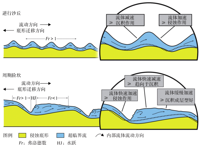
超临界流通过水跃转变为亚临界流的过程中形成各种底形[31],底形的特征取决于水流条件和泥沙颗粒大小[32],可以形成逆行沙丘(antidune)、流槽—冲坑(chute-and-pool)和周期阶坎等底形[21]。逆行沙丘呈1~2 m长的透镜状沉积,根据稳态和非稳态特征,内部层理分为水平和交错层理,倾向上游,倾角较小,常与平行层理及冲刷构造共存,弗洛德数为0.8~1.8[33]。流槽—冲坑沉积具有陡峭的、向上倾斜的层状纹理,流体的弗洛德数(1.6~2.1)高于逆行沙丘[21,34],呈现不规则间隔、阶梯式水跃迁移的特征[15]。周期阶坎很难与逆行沙丘区分开来,两者的形成条件和沉积过程极其相似[15]。下面列举了周期阶坎与逆行沙丘的异同点[35](图2)。
图2
2 周期阶坎的形成环境与底形特征
周期阶坎的形成主要与海底地形和超临界流过程有关。一方面,海底地形影响了周期阶坎的发育,形成具有不同特征的周期阶坎;另一方面,周期阶坎是海底底形的一种具体形式,周期阶坎的特征参数反映了海底地形地貌特征和流体状态。
2.1 沉积环境
表1 不同沉积环境下的周期阶坎
Table 1
| 沉积环境 | 尺度大小 | 形成机理 | 结构特征 | 沉积物组成 | 实例 |
|---|---|---|---|---|---|
| 河口三角洲 | 波长:30~300 m 波高:1~8 m | 多数由羽状流触发的浊流 | 多为新月形,阶坎较为连续,数量较多 | 砂质、泥质沉积物 | 加拿大斯阔米什三角洲[37] |
| 海底峡谷水道 | 小型:整体长度小于10 km,波长20~100 m,波高0.5~5.0 m; 中型:整体长度10~50 km,波长200~1 100 m,波高20~50 m; 大型:整体长度大于50 km,波长300~7 200 m,波高5~220 m | 海底峡谷—水道内壁垮塌、驻波、内波等触发的浊流 | 以新月形为主,上游尺度较小、对称性较差,下游尺度较大、对称性较好 | 近端粗粒砂岩,远端细粒砂岩、黏土 | 南海东北陆坡西澎湖峡谷[12],非洲Rio Muni盆地[11] |
| 碳酸盐台地 | 波长:96~117 m 波高:3.5~4.3 m | 台地顶部沉积物向深海盆地搬运形成的线性倾泻密度流 | 不仅沿流动方向纵向排列,横向上也成线性排列 | 碳酸盐岩 | 墨西哥湾巴哈马台地[13,14,38] |
2.2 形态特征
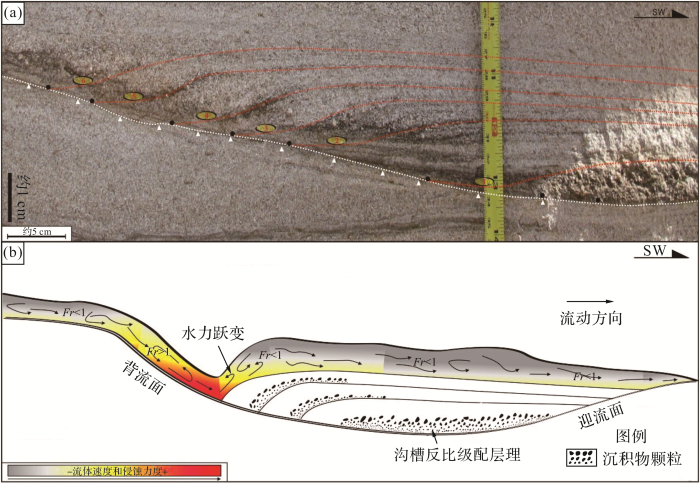
通过高分辨率多波束数据分析,揭示峡谷水道中的周期阶坎外形特征呈现为排成一列的新月形。在被解释为周期阶坎之前,内潮[39]、蠕动[40]和超临界流都被认为是新月形底形的成因。近些年,通过形态动力学分析,超临界流成因更加符合新月形底形的形态特征。Covault等[41]利用自主式水下航行器(Automatic Underwater Vehicle,AUV)多波束和浅地层剖面数据,揭示了周期阶坎的形态特征,呈现长波形、不对称、向上游迁移的新月形(图3)。海底峡谷和水道内周期阶坎都呈现新月形的外形特征,主要原因是超临界流在峡谷、水道横截面上的侵蚀能力差异。峡谷和水道的横截面呈现U形或V形,在中泓线上的超临界流流速最大、侵蚀沉积作用最明显[43],超临界流的侵蚀能力由中泓线向峡谷、水道边界逐渐减弱,形成向上游迁移的新月形特征(图3a~c)。
图3
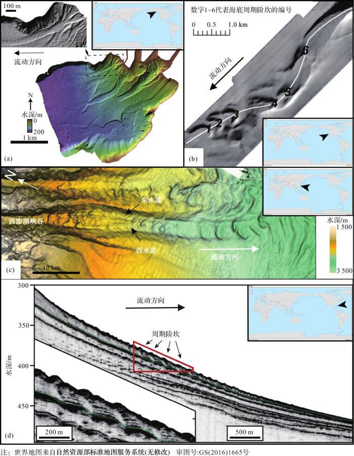
图3
不同环境下的周期阶坎(据参考文献[12,13,41,42]修改)
(a)加拿大斯阔米什三角洲;(b) 美国西海岸圣马特奥水道;(c)中国南海东北陆坡西澎湖峡谷;(d)墨西哥湾巴哈马碳酸盐台地
Fig.3
Cyclic steps in different environments (modified after references[12,13,41,42])
(a) Squamish prodelta of Canada; (b) The San Mateo channel of the west coast of USA; (c) West Penghu Canyon on the northeastern continental slope of the South China Sea; (d) The Great Bahama carbonate platform of the gulf of Mexico
2.3 层理结构
图4
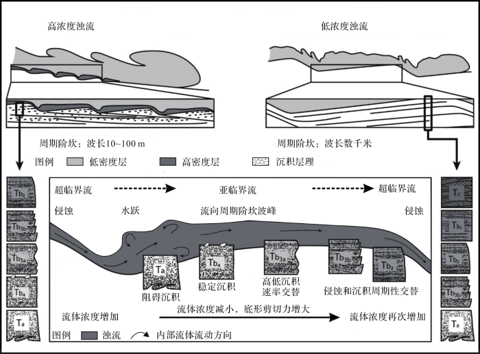
图5
3 周期阶坎的形成机理
在泥沙运动力学理论基础之上,进行了水槽实验和数值模拟,建立了周期阶坎的形态动力学模型。
3.1 水槽实验
周期阶坎的形成主要是超临界流与海底之间的相互作用。高流态的底形是一种瞬时、不稳定的状态[53]。沉积物波可以由先成底形产生[47],周期阶坎可能由其他底形转换而来。Cartigny等[21]通过水槽实验揭示逆行沙丘、不稳定沙丘、流槽—冲坑和周期阶坎之间的依次过渡关系。当超临界流速度增加、泥沙浓度增加时,从短波长的逆行沙丘逐渐向更长波长的不稳定逆行沙丘、流槽—冲坑过渡,最后形成长波状周期阶坎。形成周期阶坎的超临界流具有如下特征:
3.2 数值模拟
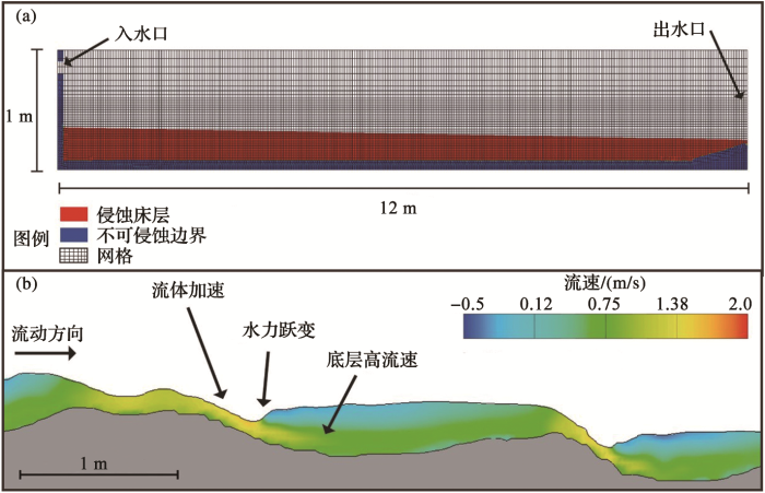
通过改变数值模拟过程中的不同参量,模拟超临界流和底形的相互关系、周期阶坎发育情况。根据模拟维度,主要有一维的“平均四方程”模型和二维的FLOW-3D软件模拟。
3.2.1 “平均四方程”模型
式中:
图6
3.2.2 FLOW-3D模拟
图7
4 不同研究手段之间的尺度差异
近些年,随着海底周期阶坎研究的深入,对于其形态和结构的精细化有着更高的要求。目前,对于周期阶坎的研究方法主要有水下观测、野外露头以及数值模拟。不同的观测手段揭示的尺度不同,从而影响对周期阶坎形态结构的认知差异。
4.1 探测设备的差异性
海底周期阶坎形态特征和内部结构的观测数据,主要通过船载多波束、浅地层剖面和人工地震以及AUV或ROV多波束、浅地层剖面获得。人工地震、多波束和浅地层剖面可以观测到周期阶坎的波长、波高等关键形态以及内部层理结构,作业水深、搭载平台和探测设备精度会影响底形观测。对于多波束和浅地层剖面而言,其分辨率一方面取决于设备本身,另一方面取决于观测区域的水深。Clarke[57]提出典型声纳系统的水平分辨率和垂直分辨率分别为水深的3.5%~20.0%和0.2%~0.8%。因此,在深水区域,船测数据分辨率将降低,不能揭示垂向尺度小于1 m的微观底形特征。例如,平均水深4 000~5 000 m的加拿大东部海域,船载多波束测深数据的垂向分辨率为40 m(表2)。因此,对于形态较小的深水周期阶坎(波长小于100 m,波高小于6 m)的观测可能会存在偏差。人工地震数据的分辨率一方面由频带控制(垂直分辨率)和道间距控制(水平分辨率);另一方面又受沉积层的速度结构影响,在同等频带条件下,沉积层的速度越高,垂向分辨率越低。根据前人研究,深水海底周期阶坎主要是由泥岩和砂岩组成的沉积物,地层速度约为1 500 m/s,如果地震的主要频带为30~70 Hz,地震分辨率为5.36~12.50 m。例如,南海西澎湖峡谷内的周期阶坎,垂直分辨率为11~17 m(表2)。随着水深增加,尤其在水深大于500 m的深水区域,海水的能量吸收作用增强,船测数据的频率都会降低,垂向分辨率会减小。在深水区域,船测多波束、浅地层剖面和人工地震数据可能不足以揭示周期阶坎的外部形态和内部层理结构。随着AUV技术的发展,搭载多波束和浅地层剖面仪器潜入海中,始终与海底保持恒定距离(35~50 m),获取海底浅层数据。AUV浅地层剖面的探测精度能达到分米级别,可以揭示几乎与野外露头尺度一致的周期阶坎(表2)。
表2 对比不同探测设备之间的差异性
Table 2
| 研究区域 | 水深/m | 探测设备及相关参数 | 周期阶坎特征(波长L,波高H) | |||
|---|---|---|---|---|---|---|
| 作业方式 | 人工地震 | 多波束 | 浅地层剖面 | |||
| 大巴哈马台地西南斜坡[13,14] | 600~800 | 船测 | 震源:mini GI枪;垂向分辨率:1.5~2.5 m | 网格尺寸:7.5 m | 探测深度:海底以下0~50 m,垂向分辨率:1 m | L:96~117 m H:3.5~4.3 m |
| 美国San Metro水道[41] | 200~800 | AUV搭载,距离海底50 m | - | 垂向分辨率:0.3 m,水平分辨率:1.5 m | 探测深度:海底以下0~30 m,垂向分辨率:0.1 m | L:300~1 100 m H:20~50 m |
| 非洲Rio Muni盆地[49] | 1 660~2 080 | 船测 | 主频:50 Hz,垂向分辨率:10 m | - | - | L:506~1 374 m H:10~41 m |
| 南海西澎湖峡谷[11] | 2 145~2 950 | 船测 | 主频:30~45 Hz,垂向分辨率:11~17 m | 垂向分辨率:优于水深0.5% | - | L:1 347~4 730 m H:17~146 m |
| 加拿大东部海域[47] | 4 000~5 000 | 船测、深拖 | 深拖,电火花震源主频:1.5 kHz,垂向分辨率:1.5 m;船测,震源:GI枪,垂向分辨率:4~10 m | 船测,网格尺寸:60 m | 船测,探测深度:海底以下0~5 m,垂向分辨率:1 m | L:600~4 000 m H:10~50 m |
4.2 露头观测的局限性
周期阶坎的野外露头主要是由古浊流形成的浊积岩,根据剖面可以分析沉积物粒度、恢复周期阶坎的波长和波高等参数,从而估算古浊流的流速、流体厚度等流体参数。通过野外露头观测到的周期阶坎的尺度往往很小,甚至能够达到厘米级别,不能显示中泓线上全部周期阶坎的形态演化,具有片面性,容易引起观测结果与实际情况之间的差异。中泓线是超临界流的流动方向,水道或者海底峡谷的中泓线是研究周期阶坎内部结构的理想场所,更能揭示真实的周期阶坎特征。值得注意的是,周期阶坎的波长、波高等参数和流体流动状态是根据中泓线上的底形特征推测确定。然而,露头剖面受到出露部位和风化程度的限制,极有可能不是沿着河道/水道的中泓线。因此,野外观察到的周期阶坎露头剖面极有可能与中泓线上的周期阶坎之间存在误差(图8)。由此得出的周期阶坎特征参数和流体参数,就与形成周期阶坎底形特征的真实流体之间,存在一定偏差。为了确定真实中泓线位置,可以采用探地雷达或者人工地震,对野外露头的内部结构进行三维几何成像。例如,Lang等[17]利用高分辨率探地雷达对古冰川环境下的周期阶坎沉积结构三维成像,并且沿流动方向对周期阶坎横向和纵向的时空演化进行了解释。此外,还可以通过结合钻井、测井等方式对周期阶坎内部形成的浊积岩进行岩性分析,从而确定中泓线的位置。
图8
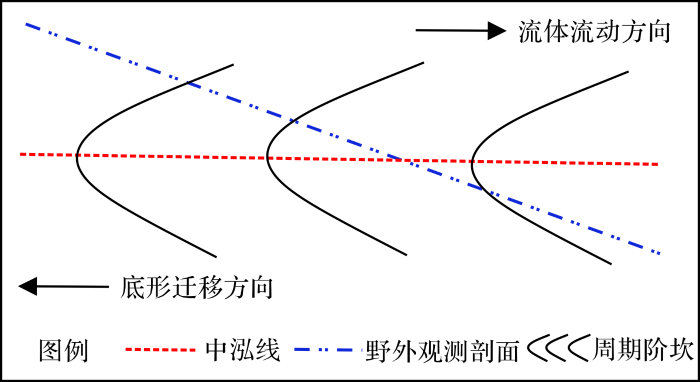
图8
周期阶坎野外露头剖面线和中泓线示意图
Fig.8
Line of outcrop profile and thalweg of cyclic steps
4.3 数值模拟的实效性
数值模拟主要是恢复周期阶坎发育演化特征以及流体状态。包括深水浊流在内的超临界流是由滑塌、大波浪、内潮和驻波等多种因素触发下引起[58~60],然而,这些触发因素都有很大的不确定性。“平均四方程”模型可以模拟周期阶坎形成过程中的自由液面与底形的相互作用,模拟的浊流流动状态持续,泥沙浓度等参量不变。然而,“平均四方程”模型没有体现流体内部和底形之间的相互作用(表3)。FLOW-3D软件可以有效模拟水槽实验中形成的周期阶坎,模拟精度可以达到厘米级别(表3)。FLOW-3D软件可以清楚地展示流体内部的浓度、流速以及底形的动态变化,但是,在实际海底周期阶坎的模拟应用中还没有取得进展。不仅如此,目前数值模拟方法的维度仅仅停留在二维(x和y)空间,在三维(x,y和z)空间上仍然没有取得突破。
表3 对比不同模拟方法之间的差异性
Table 3
| 模拟方法 | 优缺点 | |
|---|---|---|
| 数值模拟 | 平均四方程[22] | 模拟自由液面与底形的作用关系,但是,无法反馈流体内部的动态变化和实际底形的精细特征 |
| FLOW-3D | 模拟流体和底形的相互作用,揭示泥沙浓度、流速、湍流动能、弗洛德数、剪切力等参数的动态变化,但是,尚未在实际周期阶坎模拟方面取得突破 |
5 结论与建议
周期阶坎作为超临界流的底形表征,对于深水沉积物的再次搬运、海底底形的重构有着重要作用。本文根据前人的研究,总结了海底周期阶坎不仅可以形成于碎屑岩沉积环境,例如,河口三角洲、峡谷—水道等沉积体系;而且,可以形成于碳酸盐台地周缘斜坡,例如,巴哈马台地。两种沉积环境的共同点是具有一定坡度,容易形成浊流和倾泻密度流等超临界流体。典型的周期阶坎具有新月形的形态特征,并且根据沉积性和侵蚀性可以分为净侵蚀和净沉积两大类。在海底峡谷和水道中,随着泥沙浓度和流体速度的逐渐降低,周期阶坎往往从上游的净侵蚀型向下游的净沉积型转变。采用水槽实验和数值模拟揭示周期阶坎的形成原理。着重讨论了不同观测技术手段之间的差异导致周期阶坎研究尺度的差异。
在未来研究方向上,周期阶坎的研究可能会在以下几个方面有所突破:
(1) 在水深大于500 m的深水区域,融合AUV数据、船测数据和人工地震揭示的不同尺度底形特征,更加准确获得深水周期阶坎的形态特征和内部结构。
(2) 使用载人潜水器对深水海底的周期阶坎进行原位观测和测试,获取类似野外露头的样品和观测数据。
(3) 加强对野外露头的研究,结合探地雷达、人工地震、钻井和测井等多种方法,确定中泓线的准确位置,显示周期阶坎的完整特征,完善浊积岩的沉积模式。
(4) 建立一套适用于一定地质时间内、多期次浊流流动状态下形成的周期阶坎模拟方程,并且模拟维度从二维向三维发展。
参考文献
The research progress of turbidity currents and related deep-water bedforms
[J].
浊流及其相关的深水底形研究进展
[J].
Cyclic steps: Review and aggradation-based classification
[J].
Quantification of near-bed dense layers and implications for seafloor structures: New insights into the most hazardous aspects of turbidity currents
[C]//
Turbidity current measurements in the Congo Canyon
[C]//
Designing for turbidity currents in the Congo Canyon
[C]//
Recognition of cyclic steps in sandy and gravelly turbidite sequences, and consequences for the Bouma facies model
[J].
Supercritical-flow structures on a Late Carboniferous delta front: Sedimentologic and paleoclimatic significance
[J].
Cyclic steps and related supercritical bedforms: Building blocks of deep-water depositional systems, western North America
[J].
Erosion and deposition by supercritical density flows during channel avulsion and backfilling: Field examples from coarse-grained deepwater channel-levée complexes (Sandino Forearc Basin, southern Central America)
[J].
Evidence for superelevation, channel incision, and formation of cyclic steps by turbidity currents in Eel Canyon, California
[J].
northeast South China Sea
[C]//
Cyclic steps along the South Taiwan Shoal and West Penghu submarine canyons on the northeastern continental slope of the South China Sea
[J].
Periplatform drift: The combined result of contour current and off-bank transport along carbonate platforms
[J].
Sedimentary dynamics along carbonate slopes (Bahamas archipelago)
[J].
Lateral and vertical facies relationships of bedforms deposited by aggrading supercritical flows: From cyclic steps to humpback dunes
[J].
Upslope-migrating bedforms in a proglacial sandur delta: Cyclic steps from river-derived underflows?
[J].
3D architecture of cyclic-step and antidune deposits in glacigenic subaqueous fan and delta settings: Integrating outcrop and ground-penetrating radar data
[J].
Asymmetrical, inversely graded, upstream-migrating cyclic steps in marine settings: Late Miocene-early Pliocene Fish Creek-Vallecito Basin, southern California
[J].
Morphodynamics of supercritical turbidity currents in the channel-lobe transition zone
[C]//
Transportational cyclic steps created by flow over an erodible bed. Part 1. Experiments
[J].
Morphodynamics and sedimentary structures of bedforms under supercritical-flow conditions: New insights from flume experiments
[J].
Modeling of submarine cyclic steps: Controls on their formation, migration, and architecture
[J].
Morphodynamics and depositional signature of low-aggradation cyclic steps: New insights from a depth-resolved numerical model
[J].
The response of turbidity currents to a canyon-fan transition: Internal hydraulic jumps and depositional signatures
[J].
Transportational cyclic steps created by flow over an erodible bed. Part 2. Theory and numerical simulation
[J].
Purely erosional cyclic and solitary steps created by flow over a cohesive bed
[J].
Cyclic steps and significance to deep water sedimentation
[J].
周期性阶坎的特征及其对深水沉积研究的意义
[J].
Processes that initiate turbidity currents and their influence on turbidites: A marine geology perspective
[J].
How are subaqueous sediment density flows triggered, what is their internal structure and how does it evolve? Direct observations from monitoring of active flows
[J].
Key future directions for research on turbidity currents and their deposits
[J].
A consideration of the dune: Antidune transition in fine gravel
[J].
Bedforms and associated sedimentary structures formed under supercritical water flows over aggrading sand beds
[J].
Evolution of a carbonate delta generated by gateway‐funnelling of episodic currents
[J].
Water on Mars: Do submarine cyclic steps exist on the red planet?
[J].
First wide-angle view of channelized turbidity currents links migrating cyclic steps to flow characteristics
[J].
Morphometric analysis of plunge pools and sediment wave fields along western Great Bahama Bank
[J].
Semiannual patterns of erosion and deposition in upper Monterey Canyon from serial multibeam bathymetry
[J].
Origins of large crescent-shaped bedforms within the axial channel of Monterey Canyon, offshore California
[J].
Submarine channel initiation, filling and maintenance from sea-floor geomorphology and morphodynamic modelling of cyclic steps
[J].
in Landslides and engineered slopes: Protecting society through improved understanding
[M]//
A comparative study of sediment waves and cyclic steps based on geometries, internal structures and numerical modeling
[J].
Large-scale sediment waves and scours on the modern seafloor and their implications for the prevalence of supercritical flows
[J].
Deep‐sea channel evolution and stratigraphic architecture from inception to abandonment from high‐resolution autonomous underwater vehicle surveys offshore central California
[J].
Experiments on wegde-shaped deep sea sedimentary deposits in minibasins and/or on channels levees emplaced by turbidity currents. Part II. Morphodynamic evolution of the wedge and of the associated bedforms
[J].
The influence of turbidity currents and contour currents on the distribution of deep‐water sediment waves offshore eastern Canada
[J].
Cyclic steps: A phenomenon of supercritical shallow flow from the high mountains to the bottom of the ocean
[J].
Gradual transition from net erosional to net depositional cyclic steps along the submarine distributary channel thalweg in the rio muni basin: A joint 3‐D seismic and numerical approach
[J].
Supercritical and subcritical turbidity currents and their deposits—A synthesis
[J].
Flow transformations in sediment gravity flows
[J].
Large floating clasts in turbidites: A mechanism for their emplacement
[J].
Role of upper-flow-regime bedforms emplaced by sediment gravity flows in the evolution of deltas
[J].
Incisional cyclic steps of permanent form in mixed bedrock-alluvial rivers
[J].
Comparing examples of modern and ancient turbidite systems: Problems and concepts
[M]//
Large wave-shaped bedforms in the axial channel of Monterey Submarine Canyon: Monterey Bay, California
[C]//AGU Fall Meeting Abstracts.
The effect of fine scale seabed morphology and texture on fidelity of Swath bathymetric sounding data
[J].
Caught in the act: The 20 December 2001 gravity flow event in Monterey Canyon
[J].
Currents in submarine canyons: An air-sea-land interaction
[J].
Bankfull hydraulic geometry of submarine channels created by turbidity currents: Relations between bankfull channel characteristics and formative flow discharge
[J].
