

Distribution of Cold-Arid Agroclimatic Resources in China using the Cold-Arid Synergy Index (CASI)
Received date: 2025-08-05
Revised date: 2025-08-25
Online published: 2025-10-31
Supported by
the National Natural Science Foundation of China Regional Innovation and Development Joint Fund Program(U24A20604)
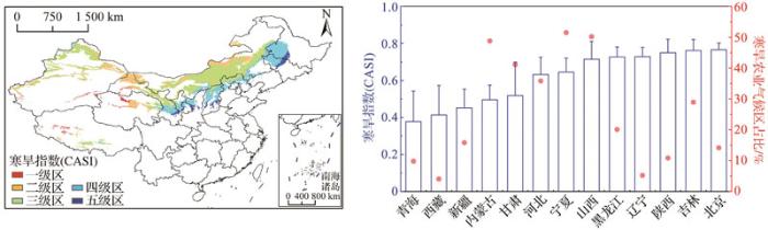
Cold-arid regions cover more than half of China’s land area. However, their climatic and environmental conditions have long constrained agricultural development. To fully exploit the advantages of agroclimatic resources, expand the endowment of climatic resources, and explore localized agricultural development pathways, it is essential to scientifically understand the distribution characteristics of agroclimatic resources and study the intrinsic traits of climatic resources in China's cold arid regions. Based on meteorological data with a 4 km resolution from 2000 to 2020, this study constructed a Cold-Arid Synergy Index (CASI), integrating the dual dimensions of thermal limitation (Thermal Restriction Index, TRI) and moisture stress (Hydrological Stress Index, HSI). This index quantifies the spatial differentiation pattern of cold-arid interactive stress and analyzes the contribution mechanisms of its dominant factors. The results showed that cold-arid agroclimatic zones in China account for 16.42% of the national land area and exhibit a northeast-southwest belt-shaped distribution. CASI-based zoning revealed a five-category gradient: Grade I zones (extreme stress) are primarily located on the Tibetan Plateau, Grades II and III zones (Hexi Corridor, Inner Mongolia Plateau) form the main body of the agro-pastoral ecotone, and Grades IV and V zones (Northeast Plain to Central Gansu) have optimal hydrothermal matching and are suitable for large-scale agricultural production. At the provincial scale, provinces such as Gansu and Inner Mongolia have over 40% of their area classified as cold-arid, with CASI standard deviations reaching 0.10~0.18, highlighting the climatic sensitivity of transition zones. The LISA spatial autocorrelation analysis indicated that 28.52% of the cold-arid area comprises Low-Low clusters (LL-type), representing core advantageous production areas; while 28.24% belong to High-High cluster areas (HH-type), forming agroclimatic high-risk islands that require targeted enhancement of climate resilience. The dominant factor analysis revealed that aridity-dominant zones account for 73%, whereas cold-dominant zones account for 27%, with the contribution of cold stress increasing significantly with elevation. The CASI system constructed in this study provides a novel methodology for cold-arid agroclimatic zoning, and the zoning results offer a scientific basis for optimizing the agricultural spatial layout, enabling precise resource allocation, and developing specialized industries within cold-arid regions in the context of climate change.
Ying WANG , Qiang ZHANG , Yun SUN , Yubi YAO , Xinyuan FENG . Distribution of Cold-Arid Agroclimatic Resources in China using the Cold-Arid Synergy Index (CASI)[J]. Advances in Earth Science, 2025 , 40(9) : 961 -973 . DOI: 10.11867/j.issn.1001-8166.2025.082
| [1] | YANG Suchang, CHEN Xiaoxiang, SHANG Mingrui. Research on the concept and development of cold and arid agriculture from the perspective of cold and arid region classification in Gansu[J]. Journal of Cold-Arid Agricultural Sciences, 2024(2): 99-108,96. |
| 杨肃昌, 陈潇湘, 尚明瑞. 基于甘肃寒旱区域划分视角的寒旱农业概念和发展问题研究[J]. 寒旱农业科学, 2024(2): 99-108, 96. | |
| [2] | LIU Yansui, ZHANG Ziwen, WANG Jieyong. Regional differentiation and comprehensive regionalization scheme of modern agriculture in China[J]. Acta Geographica Sinica, 2018, 73(2): 203-218. |
| 刘彦随, 张紫雯, 王介勇. 中国农业地域分异与现代农业区划方案[J]. 地理学报, 2018,73(2): 203-218. | |
| [3] | HU Shuyun, LU Yuqi. Identification and development of arable land in cold and cool areas of Gansu Province[J]. Arid Land Geography, 2025, 48(2): 257-270. |
| 胡舒云, 陆玉麒. 甘肃省冷凉区宜农空间识别与开发[J]. 干旱区地理, 2025, 48(2): 257-270. | |
| [4] | ZHANG Rong. Practices and revelation of technological innovation in modern cold and arid agriculture[J]. Journal of Cold-Arid Agricultural Sciences, 2023(7): 594-597. |
| 张荣. 现代寒旱农业技术创新的实践与启示[J]. 寒旱农业科学, 2023(7): 594-597. | |
| [5] | ZHOU Guohua, LONG Hualou, LIN Wanlong, et al. Theoretical debates and practical development of the “three rural issues” and rural revitalization in the New Era[J]. Journal of Natural Resources, 2023, 38(8): 1 919-1 940. |
| 周国华, 龙花楼, 林万龙, 等. 新时代“三农”问题和乡村振兴的理论思考与实践发展[J]. 自然资源学报, 2023,38(8): 1 919-1 940. | |
| [6] | LI Fengmin. Dryland agroecology[M]. Beijing: Higher Education Press, 2016. |
| 李凤民. 旱地农业生态学[M]. 北京: 高等教育出版社,2016. | |
| [7] | HU Shuyun, LU Yuqi, HU Guojian. Identification, development and insight of cold and cool agroecological resources in the middle altitude region of China[J]. Journal of Natural Resources, 2024, 39(2): 446-464. |
| 胡舒云, 陆玉麒, 胡国建. 中国中海拔地区冷凉型农业生态资源识别、开发与启示[J]. 自然资源学报, 2024,39(2): 446-464. | |
| [8] | SUO Yalin, LAN Ni, LAN Yunfeng. Analysis and prospect of the development of eco-economic zones(regions)with cold climate in northern China[J]. Agricultural Outlook, 2020, 16(12): 72-77, 84. |
| 索亚林, 兰妮, 兰云峰. 中国北方冷凉气候生态经济带(区)发展分析与展望[J]. 农业展望, 2020,16(12): 72-77, 84. | |
| [9] | ZHANG Xucheng, FANG Yanjie. Current agricultural production status and research direction in the future in cold and arid regions of Gansu Province[J]. Journal of Cold-Arid Agricultural Sciences, 2022(10): 12-18. |
| 张绪成, 方彦杰. 甘肃寒旱农业生产现状及未来研究方向[J]. 寒旱农业科学, 2022(10): 12-18. | |
| [10] | LI Yuanyuan, LI Yunling, GUO Xuning, et al. Spatial-temporal distribution and variation characteristics of water resources in China during 1956-2016[J]. Advances in Water Science, 2025, 36(1): 18-27. |
| 李原园, 李云玲, 郭旭宁, 等. 1956—2016 年中国水资源总量时空分布规律及变化特征[J]. 水科学进展, 2025, 36(1): 18-27. | |
| [11] | GAO Jiangbo, LIU Lulu, GUO Linghui, et al. Synergic effects of climate change and phenological variation on agricultural production and its risk pattern in black soil region of Northeast China[J]. Acta Geographica Sinica, 2022, 77(7): 1 681-1 700. |
| 高江波, 刘路路, 郭灵辉, 等. 气候变化和物候变动对东北黑土区农业生产的协同作用及未来粮食生产风险[J]. 地理学报, 2022, 77(7): 1 681-1 700. | |
| [12] | YAN Jiani, ZHAO Huafu, YANG Xia, et al. Evaluation on resilience of cultivated land and management in agro-pastoral ecotone of Inner Mongolia Autonomous Region[J]. Bulletin of Soil and Water Conservation, 2025, 45(3): 374-384. |
| 阎佳妮, 赵华甫, 杨霞, 等. 内蒙古农牧交错区耕地韧性评价及管控[J]. 水土保持通报, 2025,45(3): 374-384. | |
| [13] | YAN Yingjie, ZHOU Hongfei, ZHU Wei, et al. Matching patterns of water and land resources in the rain-fed agricultural region of Central Asia under future climate change scenarios[J]. Agricultural Research in the Arid Areas, 2021, 39(3): 184-193. |
| 闫英杰, 周宏飞, 朱薇, 等. 未来气候变化情景下中亚雨养农业区水土资源匹配格局[J]. 干旱地区农业研究, 2021,39(3): 184-193. | |
| [14] | WANG Xiaowen, LI Jimin. From poverty alleviation by industries to rural revitalization: development progress of poverty alleviation by industries in arid farming area of Hexi Corridor[J]. Journal of Northwest A&F University (Social Science Edition), 2021, 21(4): 17-23. |
| 汪晓文, 李济民. 从产业扶贫到乡村振兴: 河西走廊寒旱农区产业扶贫发展历程[J]. 西北农林科技大学学报(社会科学版), 2021, 21(4): 17-23. | |
| [15] | SUN Kai, DING Xiaolei. Historical retrospect and prospect of agricultural regionalization development in China[J]. Agricultural Archaeology, 2024(3): 73-81. |
| 孙凯, 丁晓蕾. 中国农业区划发展的历史回溯与未来展望[J]. 农业考古, 2024(3): 73-81. | |
| [16] | National Agricultural Regionalization Commission. Comprehensive agricultural regionalization of China[M]. Beijing: China Agriculture Press, 1981. |
| 全国农业区划委员会. 中国综合农业区划[M]. 北京: 农业出版社,1981. | |
| [17] | LIANG Xinyuan, JIN Xiaobin, SUN Rui, et al. Optimal allocation of land resources and its key issues from a perspective of food security[J]. Journal of Natural Resources, 2021, 36(12): 3 031-3 053. |
| 梁鑫源, 金晓斌, 孙瑞, 等. 粮食安全视角下的土地资源优化配置及其关键问题[J]. 自然资源学报, 2021, 36(12): 3 031-3 053. | |
| [18] | ZHANG Qiang, HUANG Jianping, YANG Jinhu, et al. Advances in research on climate change and its effects on the arid and semi-arid regions of China over the past century[J]. Acta Meteorologica Sinica, 2025, 83(3): 699-715. |
| 张强, 黄建平, 杨金虎, 等. 中国干旱、半干旱区气候变化及影响研究百年进展[J]. 气象学报, 2025,83(3): 699-715. | |
| [19] | ZHANG J L, LIU B, REN S Q, et al. A 4?km daily gridded meteorological dataset for China from 2000 to 2020[J]. Scientific Data, 2024, 11. DOI: 10.1038/s41597-024-04029-x . |
| [20] | PENG Shouzhang. China 1 km annual aridity index dataset (1901-2024) [DB]. National Tibetan Plateau Data Center, 2023. DOI:10.11888/Atmos.tpdc.300560 . |
| 彭守璋. 中国1km逐年干燥度数据集(1901-2024)[DB]. 国家青藏高原科学数据中心,2023. DOI:10.11888/Atmos.tpdc.300560 . | |
| [21] | XING Xiaoyu, YANG Xiuchun, YANG Dong, et al. Spatiotemporal evolution and driving forces of long-term aboveground biomass in grasslands of Xinjiang[J]. Resources Science, 2024, 46(8): 1 508-1 522. |
| 邢晓语, 杨秀春, 杨东, 等. 新疆草地长时序地上生物量时空演变及其驱动力[J]. 资源科学, 2024,46(8): 1 508-1 522. | |
| [22] | DING Y X, PENG S Z. Spatiotemporal trends and attribution of drought across China from 1901-2100[J]. Sustainability, 2020, 12(2). DOI: 10.3390/su12020477 . |
| [23] | LI X, ZHANG F, WANG Y J. Low-temperature tolerance during seed germination of highland barley: physiological and molecular mechanisms[J]. Journal of Agronomy and Crop Science, 2019, 205(5): 528-540. |
| [24] | WEI Weidong, LIU Yuhong, MA Hui, et al. Analysis of freeze-thaw action characteristics in shallow layer soil of degraded alpine steppe[J]. Acta Agriculturae Boreali-Occidentalis Sinica, 2018, 27(9): 1 358-1 366. |
| 魏卫东, 刘育红, 马辉, 等. 退化高寒草原浅层土壤冻融作用特征分析[J]. 西北农业学报, 2018,27(9): 1 358-1 366. | |
| [25] | WANG Zhiying, ZANG Shuying, ZHOU Daowei, et al. Temporal and spatial variation of agricultural threshold temperature from 1957 to 2016[J]. Scientia Geographica Sinica, 2020, 40(1): 137-148. |
| 王智颖, 臧淑英, 周道玮, 等. 1957—2016年中国农业界限温度时空变化研究[J]. 地理科学, 2020,40(1): 137-148. | |
| [26] | LIU Z J, LIU Y S, LI Y R. Extended warm temperate zone and opportunities for cropping system change in the Loess Plateau of China[J]. International Journal of Climatology, 2019, 39(2): 658-669. |
| [27] | LI Guangwen. Frost-free periods in high-cold region during 1961-2017: variation characteristics and the accumulated temperature[J]. Chinese Agricultural Science Bulletin, 2019, 35(20): 70-74. |
| 李广文. 高寒地区1961—2017年无霜期及其积温变化特征[J]. 中国农学通报, 2019,35(20): 70-74. | |
| [28] | ZHANG Zhiwei, YANG Yonge, LIANG Xiaojuan, et al. Characteristics of heat resource changes in Ningxia under the background of climate change[J]. Journal of Gansu Agricultural University, 2025, 60(2): 254-264. |
| 张志伟, 杨永娥, 梁小娟, 等. 气候变化背景下宁夏热量资源变化特征[J]. 甘肃农业大学学报, 2025, 60(2): 254-264. | |
| [29] | DENG Zhenyong, ZHANG Qiang, NING Huifang, et al. Influence of climate warming and drying on crop eco-climate adaptability in northwestern China[J]. Journal of Desert Research, 2010, 30(3): 633-639. |
| 邓振镛, 张强, 宁惠芳, 等. 西北地区气候暖干化对作物气候生态适应性的影响[J]. 中国沙漠, 2010,30(3): 633-639. | |
| [30] | Qinghai Provincial Administration for Market Regulation. Technical guide for agroclimatic regionalization of grain crops: [S]. Xining, 2023. |
| 青海省市场监督管理局. 粮食作物农业气候区划技术指南: [S]. 西宁,2023. | |
| [31] | SAATY T L. The analytic hierarchy process: planning, priority setting, resource allocation[M]. New York, London: McGraw-Hill International Book Co., 1980. |
| [32] | MIDDLETON N, THOMAS D S G. World atlas of desertication[M]. 2nd ed. London, Arnold; New York: John Wiley, 1997. |
| [33] | YU Xiaojing, ZHANG Lixia, ZHOU Tianjun, et al. Long-term changes in the effect of drought stress on ecosystems across global drylands[J]. Science China: Earth Sciences, 2023, 53(1): 151-166. |
| 于晓晶, 张丽霞, 周天军, 等. 干旱事件对全球干旱区生态系统胁迫作用的长期变化[J]. 中国科学: 地球科学, 2023,53(1): 151-166. | |
| [34] | National Technical Committee 38 on Agricultural Fundamentals and Generalization of SAC. Agriculture in arid areas—terminology and zoning: [S]. Beijing: Standards Press of China, 2022. |
| 全国农业基础与通用标准化工作组. 旱区农业术语与分区: [S]. 北京:中国标准出版社,2022. | |
| [35] | ANSELIN L. Local Indicators of Spatial Association: LISA[J]. Geographical Analysis, 1995, 27(2): 93-115. |
| [36] | YANG Liangshan, KE Fuyan, XU Zhiyuan, et al. Research on agricultural efficient production mode and efficiency improvement measures of agricultural photovoltaic composite system[J]. Acta Agriculturae Jiangxi, 2024, 36(5): 107-112,121. |
| 杨良山, 柯福艳, 徐知渊, 等. 农光复合系统农业高效生产模式与效率提升对策研究[J]. 江西农业学报, 2024, 36(5): 107-112, 121. | |
| [37] | WANG Xijun, HE Youhua, WANG Liming, et al. Research on the technology of rainwater collection and utilization of photovoltaic electric field in Gobi Desert[J]. Yellow River, 2020, 42(8): 73-76, 82. |
| 王喜君, 何有华, 王立明, 等. 河西走廊地区光伏电场雨水集蓄技术研究[J]. 人民黄河, 2020,42(8): 73-76, 82. | |
| [38] | LI Xiuli, Shengnian TIE, ZHANG Fenjuan. Thermal improvement of solar greenhouse on Qinghai-Tibet Plateau by modified mirabilite phase change energy storage materials[J]. Bulletin of the Chinese Ceramic Society, 2018, 37(11): 3 646-3 651. |
| 李秀丽, 铁生年, 张芬娟. 改性芒硝基相变储能材料对青藏高原日光温室环境热改善[J]. 硅酸盐通报, 2018, 37(11): 3 646-3 651. | |
| [39] | LU Yulan, LI Guang, YAN Lijuan, et al. Impacts of climate change on the regionalization of spring wheat planting in agro-pastoral ecotone of Gansu Province, China[J]. Transactions of the Chinese Society of Agricultural Engineering, 2023, 39(24): 144-152. |
| 逯玉兰, 李广, 闫丽娟, 等. 气候变化对甘肃农牧交错带春小麦种植区划的影响[J]. 农业工程学报, 2023,39(24): 144-152. | |
| [40] | Gansu Provincial Administration for Market Regulation. Wheat variety “Ganyu No. 8”: [S]. Gansu, 2024. |
| 甘肃省市场监督管理局. 小麦品种甘育8号: [S]. 甘肃,2024. | |
| [41] | YIN Jiade, HOU Huizhi, FANG Yanjie, et al. Responses of water utilization and efficiency yield of potatoes to ridge-furrow ratiovariation under vertically rotary sub-soiling tillage in dryland areas[J]. Journal of Cold-Arid Agricultural Sciences, 2025(3): 244-249. |
| 尹嘉德, 侯慧芝, 方彦杰, 等. 旱作区立式深旋耕作下马铃薯产量及水分利用效率对垄沟比变化的响应[J]. 寒旱农业科学, 2025(3): 244-249. | |
| [42] | LI Junlin, ZHU Zhanlu. Effect of nitrogen reduction by water and fertilizer integration on potato yield and water use efficiency in Dingxi dry area[J]. Northwest Horticulture, 2025(5): 65-70. |
| 李俊林, 朱占录. 水肥一体化减氮对定西旱区马铃薯产量和水分利用效率的影响[J]. 西北园艺, 2025(5): 65-70. | |
| [43] | CUI Zhijia, LIU Fenglin, ZHANG Qili, et al. Comparative analysis of the content of Lycium barbarum polysaccharide in Lycii Fructus from different places[J]. West China Journal of Pharmaceutical Sciences, 2020, 35(1): 59-61. |
| 崔治家, 刘峰林, 张启立, 等. 不同产地枸杞子中枸杞多糖含量的比较分析[J]. 华西药学杂志, 2020, 35(1): 59-61. | |
| [44] | Ganzhou District Agriculture and Rural Affairs Bureau.Vegetable industry development report of Ganzhou district (2025)[R].Zhangye: People’s Government of Ganzhou District,2025: 8-12. |
| 甘州区农业农村局. 甘州区蔬菜产业发展报告(2025)[R]. 张掖: 甘州区人民政府,2025: 8-12. | |
| [45] | LI Yuemei. Water-fertilizercoupling technology model promotes quality improvement and efficiency improvement of Lyciumbarbarum industry in Qaidam[J]. Agriculture and Technology, 2019,39(13): 14-17. |
| 李月梅. 水肥耦合技术模式助推柴达木枸杞产业提质增效[J]. 农业与技术, 2019,39(13): 14-17. | |
| [46] | LEI Yuhong, WANG Fake, XU Xuelian, et al. Model construction of the relationship between the yield of Lycium barbarum and meteorological condition in Qaidam area[J]. Chinese Agricultural Science Bulletin, 2021, 37(13): 89-93. |
| 雷玉红, 王发科, 许学莲, 等. 柴达木地区枸杞产量与气象条件关系模型构建[J]. 中国农学通报, 2021,37(13): 89-93. | |
| [47] | WU Xiaoyan, HE Chaobo, HU Jisong, et al. Mechanized production mode of quinoa in Qaidam Basin[J]. Agricultural Engineering, 2022, 12(9): 5-10. |
| 武小燕, 何超波, 胡积送, 等. 柴达木盆地藜麦机械化生产模式[J]. 农业工程, 2022,12(9): 5-10. | |
| [48] | LIU Peng, LEI Jinhong, WANG Bo. Challenges and path optimization in the development of the seed maize industry in Zhangye City: an analysis from the perspectives of food security and policy[J]. China Seed Industry, 2025(3): 29-32. |
| 刘鹏, 雷金宏, 王博. 张掖市制种玉米产业发展中的挑战与路径优化: 基于粮食安全与政策视角的分析[J]. 中国种业, 2025(3): 29-32. | |
| [49] | WANG Xin, LIAN Wenhao, WEI Junfeng, et al. Status and problems of water resources on the Qinghai-Tibet Plateau[J]. Advances in Water Science, 2023, 34(5): 812-826. |
| 王欣, 连文皓, 魏俊锋, 等. 青藏高原水资源现状与问题[J]. 水科学进展, 2023, 34(5): 812-826. | |
| [50] | ZHANG Qiang, WANG Yuan, ZHANG Ping. Cloud water resources and precipitation conversion in northwest China[J]. Advances in Earth Science, 2025, 40(5): 473-486. |
| 张强, 王元, 张萍. 论西北地区空中云水资源特征与云降水转化机制[J]. 地球科学进展, 2025,40(5): 473-486. | |
| [51] | LI Jingyang, HE Jieying. Progress and prospects of the combined application of microwave remote sensing and infrared hyperspectral remote sensing[J]. Chinese Journal of Space Science, 2025, 45(2): 413-423. |
| 李旌阳, 何杰颖. 微波遥感与红外高光谱遥感联合应用的进展与展望[J]. 空间科学学报, 2025,45(2): 413-423. | |
| [52] | HAN Wenting, ZHANG Liyuan, NIU Yaxiao, et al. Review on UAV remote sensing application in precision irrigation[J]. Transactions of the Chinese Society for Agricultural Machinery, 2020, 51(2): 1-14. |
| 韩文霆, 张立元, 牛亚晓, 等. 无人机遥感技术在精量灌溉中应用的研究进展[J]. 农业机械学报, 2020,51(2): 1-14. | |
| [53] | ZHAO Guiping, XU Fajun. Farmland soil moisture monitoring based on UAV multispectral imagery[J]. Bulletin of Surveying and Mapping, 2024(11): 177-182. |
| 赵贵平, 徐发俊. 基于无人机多光谱影像的农田土壤水分监测[J]. 测绘通报, 2024(11): 177-182. | |
| [54] | WANG Xiaofeng, WANG Yucai. Impact of nitrogen application levels on yield, water use efficiency, and nitrogen use efficiency of Angelica sinensis under sprinkler irrigation[J]. Subtropical Plant Science, 2025, 54(3): 274-283. |
| 王晓峰, 王玉才. 喷灌条件下不同施氮水平对当归产量及水氮利用效率的影响[J]. 亚热带植物科学, 2025,54(3): 274-283. | |
| [55] | JIANG Tuanbiao, HE Jinsheng. Could digital technology lead high-quality agricultural development to break through “Hu Huanyong Line”?[J]. Journal of Agro-Forestry Economics and Management, 2025, 24(3): 330-342. |
| 蒋团标, 何金盛. 数字技术能否引领农业高质量发展突破“胡焕庸线”?[J]. 农林经济管理学报, 2025,24(3): 330-342. | |
| [56] | XI Jinping. Insist on solving the “Three Rural Issues” as the top priority of the whole party’s work, and give full play to the power of the whole party and society to promote rural revitalization[J]. Seeking Knowledge, 2022(4): 4-10. |
| 习近平. 坚持把解决好“三农”问题作为全党工作重中之重举全党全社会之力推动乡村振兴[J]. 求知, 2022(4): 4-10. |
/
| 〈 |
|
〉 |
