

On the Construction of China's Fiducial Reference Measurement Network for Land Surface Remote Sensing Product Validation
Received date: 2021-06-18
Revised date: 2021-11-17
Online published: 2022-01-20
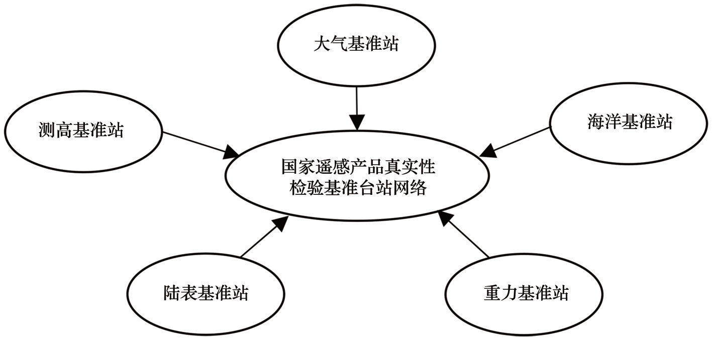
A series of land surface parameter products have been generated by various satellite remote sensing data over the globe. These products have been widely applied in Earth system science research and national decision-making support. In order to make better use of these products, it is necessary to understand the quality and accuracy information of the products. The purpose of land surface validation is to provide an independent assessment of the accuracy of the remote sensing products with land surface reference measurements. Fiducial Reference Measurement (FRM) provides independent, standard and regular field measurements, which are indispensable for the validation of land surface remote sensing products. FRM data are of profound significance for understanding the history, present conditions and future changes of the land surface system. This paper started with a brief overview of recent advancement in the construction of surface reference networks over the globe and analyzed the construction of the validation networks for land surface remote sensing products in China. Based on the overview, the paper put forward the basic ideas on building a FRM for the validation of land surface remote sensing products in China. The design scheme, station selection, instrument selection, organization and management of the FRM were described. Combining the land surface FRM with atmospheric, oceanic, altimetry and earth gravity FRMs, a national FRM framework can be constructed. In addition, a national land surface supersite network, with multiple observed variables at each site, can be built out of existing core sites and FRM sites. Construction of the national land surface FRM will greatly help the validation of remote sensing products, facilitate Earth system science studies, and improve serving the decision support with remote sensing products.
Hongliang FANG , Tao CHE , Rui JIN , Ainong LI , Xin LI , Zengyuan LI , Shaomin LIU , Mingguo MA , Qing XIAO , Yongguang ZHANG . On the Construction of China's Fiducial Reference Measurement Network for Land Surface Remote Sensing Product Validation[J]. Advances in Earth Science, 2021 , 36(12) : 1215 -1223 . DOI: 10.11867/j.issn.1001-8166.2022.003
| 1 | LIANG Shunlin, ZHANG Xiaotong, XIAO Zhiqiang, et al. Global Land Surface Satellite (GLASS) products: algorithms, verification and analysis [M]. Beijing: Higher Education Press, 2014. |
| 1 | 梁顺林, 张晓通, 肖志强, 等. 全球陆表特征参量(GLASS)产品:算法、验证与分析[M].北京: 高等教育出版社, 2014. |
| 2 | GCOS.Systematic observation requirements for satellite-based products for climate, 2011 update, supplemental details to the satellite-based component of the implementation plan for the global observing system for climate in support of the UNFCCC (2010 Update) [C]. Switzerland:World Meteorological Organization, 2011. |
| 3 | State Administration of Market Supervision and Administration, China National Standardization Administration Committee. National standards of the People's Republic of China: guide for the validation of remote sensing products: [S]. (2018-06-07) [2021-06-17]. http://std.samr.gov.cn/gb/search/gbDetailed?id=71F772D82ABAD3A7E05397BE0A0AB82A. [国家市场监督管理总局, 中国国家标准化管理委员会. 中华人民共和国国家标准遥:感产品真实性检验导则: [S]. (2018-06-07)[2021-06-17]. ] |
| 4 | LI Xiaowen. Review of the project of quantitative remote sensing of major factors for spatial-temporal heterogeneity on the land surface [J]. Advances in Earth Science, 2006,21(8): 771-780. |
| 4 | 李小文. 地球表面时空多变要素的定量遥感项目综述[J]. 地球科学进展, 2006, 21(8): 771-780. |
| 5 | LI Xin, MA Mingguo, WANG Jian, et al. Simultaneous remote sensing and ground-based experiment in the Heihe River Basin: scientific objective and experiment design [J]. Advances in Earth Science, 2008, 23(9): 897-914. |
| 5 | 李新, 马明国, 王建, 等. 黑河流域遥感—地面观测同步试验:科学目标与试验方案[J]. 地球科学进展, 2008,23(9): 897-914. |
| 6 | WIDLOWSKI J L. Conformity testing of satellite-derived quantitative surface variables [J]. Environmental Science & Policy, 2015, 51: 149-169. |
| 7 | THORNE P W, DIAMOND H J, GOODISON B, et al. Towards a global land surface climate fiducial reference measurements network [J]. International Journal of Climatology, 2018, 38(6): 2 760-2 774. |
| 8 | JIANG Weiping. Challenge and opportunities of GNSS reference station network [J]. Acta Geodaetica et Cartographica Sinica, 2017, 46(10): 1 379-1 388. |
| 8 | 姜卫平. 卫星导航定位基准站网的发展现状、机遇与挑战[J]. 测绘学报, 2017,46(10): 1 379-1 388. |
| 9 | DIAMOND H J, KARL T R, PALECKI M A, et al. U.S. Climate Reference Network after one decade of operations: status and assessment [J]. Bulletin of the American Meteorological Society,2013,94(4): 485-498. |
| 10 | MILEWSKA E J, VINCENT L A. Preserving continuity of long-term daily maximum and minimum temperature observations with automation of reference climate stations using overlapping data and meteorological conditions [J]. Atmosphere-Ocean, 2016, 54(1): 32-47. |
| 11 | FOX N. Principles of metrology, FRM and their applicability to earth observation [C]// ESA Workshop on Land Validation Strategy Programme. Vortual Meeting, 2020. |
| 12 | SONG Lianchun, LI Wei. The development of integrated meteorological observation system [J]. Journal of the Meteorological Sciences, 2008, 34(3): 3-9. |
| 12 | 宋连春, 李伟. 综合气象观测系统的发展[J]. 气象科学, 2008, 34(3): 3-9. |
| 13 | WEN Kangmin, REN Guoyu, LI Jiao, et al. Adjustment of urbanization bias in surface air temperature over the mainland of China [J]. Progress in Geography,2019,38(4): 600-611. |
| 13 | 温康民, 任国玉, 李娇, 等. 国家基本/基准站地面气温资料城市化偏差订正[J]. 地理科学进展, 2019,38(4): 600-611. |
| 14 | QU Yubo, YUE Dingli, ZHONG Liuju, et al. Establishment and operational management mechanism of Guangdong atmospheric supersite of China [J]. Journal of the Environmental Science and Management,2013,38(11): 63-67. |
| 14 | 区宇波, 岳玎利, 钟流举, 等. 中国广东大气超级监测站的规划建设与运行机制研究[J]. 环境科学与管理, 2013,38(11): 63-67. |
| 15 | BAYAT B, CAMACHO F, NICKESON J, et al. Toward operational validation systems for global satellite-based terrestrial essential climate variables [J]. International Journal of Applied Earth Observation and Geoinformation,2021, 95: 102240. |
| 16 | MA M, CHE T, LI X, et al. A prototype network for remote sensing validation in China [J]. Remote Sensing, 2015, 7(5): 5187. |
| 17 | YANG Ping. Thoughts on future development of field observation and research network of Chinese Academy of Sciences [J]. Bulletin of Chinese Academy of Sciences, 2021, 36(1): 104-112. |
| 17 | 杨萍. 中国科学院野外科学观测研究网络未来发展的思考[J]. 中国科学院院刊, 2021, 36(1): 104-112. |
| 18 | GU Xingfa, TIAN Guoliang, LI Xiaowen, et al. Quantification of remote sensing information [J]. Science in China Series E: Information Sciences, 2005():1-10. |
| 18 | 顾行发, 田国良, 李小文, 等. 遥感信息的定量化[J]. 中国科学E辑:信息科学, 2005():1-10. |
| 19 | ZHANG Y, ZHANG Q, LIU L, et al. ChinaSpec: a network for long-term ground-based measurements of solar-induced fluorescence in China [J]. Journal of Geophysical Research: Biogeosciences, 2021,126(3): e2020JG006042. |
| 20 | HUANG Tieqing, NIU Dong. Chinese Ecosystem Research Network (CERN) [J]. Advances in Earth Science, 2005, 20(8): 895-902. |
| 20 | 黄铁青, 牛栋. 中国生态系统研究网络(CERN):概况、成就和展望[J]. 地球科学进展,2005, 20(8): 895-902. |
| 21 | VOSE R S.Reference station networks for monitoring climatic change in the conterminous United States [J]. Journal of Climate, 2005, 18(24): 5 390-5 395. |
| 22 | 2018 China High Resolution Satellite Application National Report (Standard Specification Volume) Compilation Group. 2018 China high resolution satellite application national report (standard specification volume)[R]. Beijing: Major Special Project Center of State Administration of Science, Technology and Industry for National Defense,2018. [2018中国高分卫星应用国家报告(标准规范卷)编写组. 2018中国高分卫星应用国家报告(标准规范卷)[R]. 北京:国家国防科技工业局重大专项工程中心,2018.] |
| 23 | LI Xin, JIN Rui, LIU Shaomin, et al. Upscaling research in HiWATER: progress and prospects [J]. Journal of Remote Sensing, 2016, 20(5): 921-932. |
| 23 | 李新, 晋锐, 刘绍民, 等. 黑河遥感试验中尺度上推研究的进展与前瞻[J]. 遥感学报, 2016, 20(5): 921-932. |
| 24 | HAO Dalei, XIAO Qing, WEN Jianguang, et al. Advances in upscaling methods of quantitative remote sensing [J]. Journal of Remote Sensing, 2018,22(3): 408-423. |
| 24 | 郝大磊, 肖青, 闻建光, 等. 定量遥感升尺度转换方法研究进展[J]. 遥感学报, 2018,22(3): 408-423. |
| 25 | FANG Hongliang. Scaling effects of the true and effective Leaf Area Index (LAI and LAIe) and Clumping Index (CI) [J]. Journal of Geo-information Science, 2021,23(7):1 155-1 168. |
| 25 | 方红亮. 真实和有效叶面积指数及聚集指数的尺度效应[J]. 地球信息科学学报, 2021,23(7):1 155-1 168. |
| 26 | Ministry of Science and Technology of the People's Republic of China. Measures for the administration of national field scientific observation and research stations[Z]. 2021. |
| 26 | 中华人民共和国科学技术部.国家野外科学观测研究站管理办法[Z]. 2021. |
/
| 〈 |
|
〉 |
