

A Preliminary Study of Classification Method on Lunar Topography and Landforms
First author:Cheng Weiming(1973-), male, Tianshui City, Gansu Province, Professor. Research areas include digital geomorphology and lunar topography and landforms. E-mail: chengwm@lreis.ac.cn
Received date: 2017-04-18
Revised date: 2018-08-06
Online published: 2018-10-23
Supported by
Project supported by the National Natural Science Foundation of China "Classification method on lunar morphological types"(No.41571388);The Key Research Program of the Chinese Academy of Sciences "Digital Moon and Earth-Moon system evolution"(No.XDPB11).
Copyright
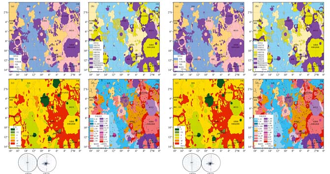
Lunar topography and landform, resulting from endogenous and exogenous geophysical processes of various spatial and temporal scales, carry information of these processes and target properties. Geoscientists use morphometric analysis at different scales to study lunar topography, which is one of the four scientific objectives of China's lunar exploration project. This article first reviewed the lunar topographic types from different researchers, analyzed classifying method and progress, discussed geological mapping method of 1∶ 5 000 000 complied by United States Geological Survey in the 1970s. In consideration of the present situation of the lunar surface morphological characteristics, the pattern of macroscopic forcing, morphologic variation and combination characteristics and function way, etc., a matrix combining multi-stage classification method was put forward based on the characteristics of the topography and geologic age, which included 7 geologic ages and 14 morphologic classes. Geological ages can be divided into Copernican System (C), Copernican-Eartosthenian System (CE), Eartosthenian System (E), Eartosthenian-Imbrian System (EI), Imbrian System (I), Imbrian-PreImbrian System (IpI) and Pre-Imbrian System (pI). As to topographic types, the first class can be divided into lunar mare, lunar basin, lunar terra and lunar crater. As to their second class according to morphological differences, the lunar basin can be divided into basin plain and circum-basin, and lunar mare can be divided into mare plain and mare dome; lunar terra can be divided into terra plain, plateau and hill, and craters can be divided into main sequence crater, crater plain, secondary crater, crater chains and clusters, rayed craters, irregular crater and undivided crater. Thus, 46 subclasses including geologic and morphologic features were obtained in this classification system. The test mapping method was addressed in Sheet H010, which shows the combination classification method is reasonable.
Weiming Cheng , Qiangyi Liu , Jiao Wang , Wenxin Gao , Jianzhong Liu . A Preliminary Study of Classification Method on Lunar Topography and Landforms[J]. Advances in Earth Science, 2018 , 33(9) : 885 -897 . DOI: 10.11867/j.issn.1001-8166.2018.09.0885
| [1] | Ouyang Ziyuan.Introduction to Lunar Science[M]. Beijing: China Astronautic Publishing House, 2005 . |
| [1] | [欧阳自远. 月球科学概论[M]. 北京:中国宇航出版社,2005.] |
| [2] | Cheng Weiming, Zhou Zengpo, Wan Cong, et al.Introduction to Lunar Morphology and Landform Science[M]. Beijing: Geological Publishing House, 2016 . |
| [2] | [程维明,周增坡,万丛,等. 月球形貌科学概论[M]. 北京:地质出版社,2016.] |
| [3] | Cheng Weiming, Wang Jiao, Zhou Chenghu.Analysis on research progress and tendency of lunar morphological characteristics[J].Geographical Research, 2014, 33(6): 1 003-1 014 . |
| [3] | [程维明,王娇,周成虎. 月球表面形貌特征研究进展及趋势分析[J]. 地理研究, 2014, 33(6): 1 003-1 014.] |
| [4] | Eliason E, Isbell C, Lee E, et al. The Clementine UVVIS Global Lunar Mosaic[R]. Houston: Lunar and Planetary Institute, 1999. |
| [5] | Bussey B, Spudis P.The Clementine Atlas of the Moon[M]. Cambridge: Cambridge University Press, 2004. |
| [6] | Rosiek M R, Kirk R, Howington-Kraus E.Color-coded Topography and Shaded Relief Maps of the Lunar Hemispheres[M]//33rd Lunar and Planetary Science Conference. Houston: Lunar and Planetary Institute, 2002. |
| [7] | Zisk S H.A new, Earth-based radar technique for the measurement of lunar topography[J]. The Moon, 1972, 4(3/4): 296-306. |
| [8] | Smith D E, Zuber M T, Neumann G A, et al. Topography of the Moon from theclementine lidar[J]. Journal of Geophysical Research, 1997, 102(1): 1 591-1 611. |
| [9] | Cook A C, Spudis P D, Robinson M S, et al. Lunar topography and basins mapped using a Clementine stereo digital elevation model[C]//33rd Annual Lunar and Planetary Science Conference. Houston, Texas, 2002, 33: 1 281-1 282. |
| [10] | Burns K N, Speyerer E J, Robinson M S, et al. Digital elevation models and derived products from LROC NAC stereo observations[J].International Society for Photogrammetry and Remote Sensing, 2012, 39(6): 483-488. |
| [11] | Araki H, Tazawa S, Noda H, et al. Lunar global shape and polar topography derived from Kaguya-LALT laser altimetry[J].Science, 2009, 323(5 916): 897-900. |
| [12] | Li Chunlai, Liu Jianjun, Ren Xin, et al. The global image of the Moon obtained by the Chang'E-1: Data processing and lunar cartography[J]. Science in China (Series D), 2010, 53(8): 1 091-1 102. |
| [13] | Li Chunlai, Ren Xin, Liu Jianjun, et al. Laser altimetry data of Chang'E-1 and the global lunar DEM model[J].Science in China(Series D), 2011, 53(11): 1 582-1 593. |
| [14] | Fok H S, Shum C K, Yi Yuchan, et al. Accuracy assessment of lunar topography models[J]. Earth, Planets and Space, 2011, 63(1): 15-23. |
| [15] | Ping Jinsong, Huang Qian, Yan Jianguo, et al. Lunar topographic model CLTM-s01 from Chang'E-1 laser altimeter[J]. Science in China (Series G), 2009, 52(7): 1 105-1 114. |
| [16] | Wu Bo, Guo Jian, Zhang Yunsheng, et al. Integration of Chang'E-1 imagery and laser altimeter data for precision lunar topographic modeling[J].IEEE Transactions on Geoscience and Remote Sensing, 2011, 49(12): 4 889-4 903. |
| [17] | Sawabe Y, Matsunaga T, Rokugawa S.Automated detection and classification of lunar craters using multiple approached[J].Advances in Space Research, 2006, 37(1): 21-27. |
| [18] | Baldwin R B.The Face of the Moon[M]. Chicago: University of Chicago Press, 1949. |
| [19] | Ronca L B, Green R R.Statistical geomorphology of the lunar surface[J].Geological Society of America Bulletin, 1970, 81(2): 337-352. |
| [20] | Lewis H A G. The Times Atlas of the Moon[M]. London: Times Newspapers, 1969. |
| [21] | Bowker D E, Hughes J K.Lunar Orbiter Photographic Atlas of the Moon[R]. Houston: Lunar and Planetary Institute, 1971. |
| [22] | Sheehan W, Dobbins T A.EpicMoon: A history of Lunar Exploration in the Age of the Telescope[M]. Richmond, Virginia: Willmann-Bell, 2001. |
| [23] | Whitaker E A.Mapping and Naming the Moon: A History of Lunar Cartography and Nomenclature[M]. Cambridge: Cambridge University Press, 2003. |
| [24] | International Astronomical Union Working Group for Planetary System Nomenclature. Gazetteer of Planetary Nomenclature[EB/OL] .[2017-03-11]. . |
| [25] | Zhou Zengpo, Cheng Weiming, Zhou Chenghu, et al. Characteristic analysis of the lunar surface and automatically extracting of the lunar morphology based on CE-1[J]. Chinese Science Bulletin, 2011, 56(1): 18-26 . |
| [25] | [周增坡, 程维明, 周成虎, 等. 基于“嫦娥一号”的月球表面形貌特征分析与自动提取[J]. 科学通报, 2011, 56(1): 18-26.] |
| [26] | Wang Jiao, Cheng Weiming, Zhou Chenghu.A global inventory of lunar craters: Identification, classification, and distribution[J].Progress in Geography, 2015, 34(3): 330-342 . |
| [26] | [王娇, 程维明, 周成虎. 全月球撞击坑识别, 分类及空间分布[J]. 地理科学进展, 2015, 34(3): 330-342.] |
| [27] | Wilhelms D E, McCauley J F. Geologic Map of the Near Side of the Moon[M]. Arizona: US Geological Survey, Map I-703, 1971. |
| [28] | Wilhelms D E, El-Baz F. Geologic Map of the East Side of the Moon[M]. Arizona: US Geological Survey, Map I-948, 1977. |
| [29] | Scott D H, McCauley J F, West M N. Geologic Map of the West Side of the Moon[M]. Arizona: US Geological Survey, Map I-1034, 1977. |
| [30] | Stuart-Alexander D E. Geologic Map of the Central Far Side of the Moon[M]. Arizona: US Geological Survey, Map I-1047, 1978. |
| [31] | Lucchitta B K.Geologic Map of the North Side of the Moon[M]. Arizona: US Geological Survey, Map I-1062, 1978. |
| [32] | Wilhelms D E, Howard K A, Wilshire H G. Geologic Map of the South Side of the Moon[M]. Arizona: US Geological Survey, Map I-1162, 1979. |
| [33] | Ding Xiaozhong, Han Kunying, Han Tonglin, et al. Compilation of the geological map of Sinus Iridum Quadrangle of the Moon (LQ-4)[J]. Earth Science Frontiers, 2012, 19(6): 15-27 . |
| [33] | [丁孝忠, 韩坤英, 韩同林, 等. 月球虹湾幅(LQ-4)地质图的编制[J]. 地学前缘, 2012, 19(6): 15-27.] |
| [34] | Chen Jianping, Wang Xiang, Xu Yanbo, et al. Compilation of the lunar geotectonic outline map based on multisource data:A case study of LQ-4 Area[J]. Earth Science Frontiers, 2012, 19(6): 1-14 . |
| [34] | [陈建平, 王翔, 许延波, 等. 基于多源数据的月球大地构造纲要图编制:以LQ-4地区为例[J]. 地学前缘, 2012, 19(6): 1-14.] |
| [35] | Ouyang Ziyuan, Liu Jianzhong.The origin and evolution of the Moon and its geological mapping[J]. Earth Science Frontiers, 2014, 21(6): 1-6 . |
| [35] | [欧阳自远, 刘建忠. 月球形成演化与月球地质图编研[J]. 地学前缘, 2014, 21(6): 1-6.] |
| [36] | Chen Jianping, Wang Xiang, Wang Nan, et al. The lunar geological mapping based on Chang'E data: Serenitatis-Tranquillitatis area as an example[J]. Earth Science Frontiers, 2014, 21(6): 7-18 . |
| [36] | [陈建平, 王翔, 王楠, 等. 基于嫦娥数据澄海—静海幅地质图编研[J]. 地学前缘, 2014, 21(6): 7-18.] |
| [37] | Florinsky I V.Global Morphometric Maps of Mars, Venus, and the Moon[M]. Berlin, Germany: Springer, 2008. |
| [38] | Rosenburg M A, Aharonson O, Head J W, et al. Global surface slopes and roughness of the Moon from the Lunar Orbiter Laser Altimeter[J].Journal of Geophysical Research: Planets, 2011, 116(E2): 1-11. |
| [39] | Xi Xiaoxu, Liu Shaofeng, Wu Zhiyuan, et al. The interpretation of land form of Sinus Iridum on the Moon based on the roughness[J].Remote Sensing for Land and Resources, 2012, 92(1): 95-99 . |
| [39] | [奚晓旭,刘少峰,吴志远,等. 基于粗糙度的月球表面虹湾地区地形地貌解译[J]. 国土资源遥感, 2012, 92(1): 95-99.] |
| [40] | Wang Chenzhi, Tang Guoan, Yuan Sai, et al. A method for identifying the lunar morphology based on texture from DEMs[J].Journal of Geo-information Science, 2015, 17(1): 45-53 . |
| [40] | [王琛智,汤国安,袁赛,等. 基于DEM 纹理特征的月貌自动识别方法探究[J]. 地球信息科学学报, 2015, 17(1): 45-53.] |
| [41] | Bue B D, Stepinski T F.Automated classification of landforms on Mars[J].Computers and Geosciences, 2006, 32(5): 604-614. |
| [42] | Li Jing, Chen Jianping, Wang Nan, et al. A new automated approach to detecting and extracting the linear structures on the lunar surface: A case study on the lunar mare ridge of Mare Serenitatis[J]. Earth Science Frontiers, 2014, 21(6): 223-228 . |
| [42] | [李婧, 陈建平, 王楠, 等. 月球表面线性构造自动提取新方法研究: 以澄海地区月岭为例[J]. 地学前缘, 2014, 21(6): 223-228.] |
| [43] | Li Ke, Chen Jianping, Tarolli P, et al. Geomorphometric multi-scale analysis for the automatic detection of linear structures on the lunar surface[J]. Earth Science Frontiers, 2014, 21(6):212-222 . |
| [43] | [李珂,陈建平,Tarolli Paolo,等. 基于多尺度数字地形定量分析的月球线性构造自动提取研究[J]. 地学前缘, 2014, 21(6): 212-222.] |
| [44] | Wang Nan.Automated Extraction and Evolution Analysis of the Lineaments on Mare Tranquillitatis of the Moon[D]. Beijing: China University of Geosciences, 2015 . |
| [44] | [王楠. 月球静海地区线性构造自动提取与演化分析[D]. 北京: 中国地质大学, 2015.] |
| [45] | Chabot N L, Hoppa G V, Strom R G.Analysis of lunar lineaments: Far side and polar mapping[J].Icarus, 2000, 147(1): 301-308. |
| [46] | Neukum G, K?nig B, Arkani-Hamed J.A study of lunar impact crater size-distributions[J]. Moon, 1975, 12(2):201-229. |
| [47] | Yue Zongyu, Liu Jianzhong, Wu Ganguo.Automated detection of lunar craters based on object-oriented approach[J]. Chinese Science Bulletin, 2008, 53(23): 3 699-3 704. |
| [48] | Moutsoulas M, Preka P.Morphological characteristics of lunar craters with small depth/diameter ratio I[J].Earth, Moon and Planets, 1979, 21(3): 299-305. |
| [49] | Grieve R A F, Pesonen L J. Terrestrial impact craters: Their spatial and temporal distribution and impacting bodies[M]//Worlds in Interaction: Small Bodies and Planets of the Solar System. Netherlands: Springer Netherlands, 1996: 357-376. |
| [50] | Ding Meng, Cao Yunfeng, Wu Qingxian.A method of craters detection from the surface imagery of Moon[J]. Journal of Astronautics, 2009, 30(3): 1 243-1 248. |
| [51] | Du Jun, Miao Fang, Lu Yuhang, et al. Research on appraisal of edge definition of impact craters[J]. Computer Engineering and Applications, 2013,49(15): 179-183 . |
| [51] | [都骏, 苗放, 鲁宇航, 等. 月球撞击坑边缘清晰度评价方法的研究[J]. 计算机工程与应用, 2013,49(15): 179-183.] |
| [52] | Bijaoui A, Froeschle M M.A new algorithm to determine image edges—Application to lunar craters[J]. Astronomy and Astrophysics, 1980, 87(1/2): 250-251. |
| [53] | Canny J.A computational approach to edge detection[J]. IEEE Transactions on Pattern Analysis and Machine Intelligence, 1986, 8(6): 679-698. |
| [54] | Salamuni?car G, Lon?ari? S, Mazarico E. LU60645GT and MA132843GT catalogues of Lunar and Martian impact craters developed using a Crater Shape—Based interpolation crater detection algorithm for topography data[J]. Planetary and Space Science, 2012, 60(1): 236-247. |
| [55] | Yuan Yuefeng, Zhu Peimin, Zhao Na, et al. Automatic identification of circular mare craters based on mathematical morphology[J]. Scientia Sinica Physica, Mechanica and Astronomica, 2013,43(3): 324-332 . |
| [55] | [袁悦锋, 朱培民, 赵娜, 等. 基于数学形态学的月海圆形撞击坑自动识别方法[J]. 中国科学: 物理学, 力学, 天文学,2013, 43(3): 324-332.] |
| [56] | Michael G G.Coordinate registration by automated crater recognition[J]. Planetary and Space Science, 2003, 51(9): 563-568. |
| [57] | Kim J R, Muller J P, Mor ley J G. Quantitative assessment of automated crater detection on Mars[C]//2004 ISPRS Congress. Istanbul, Turkey: ISPRS, 2004. |
| [58] | Leroy B, Medioni G, Johnson E, et al. Crater detection for autonomous landing on asteroids[J]. Image and Vision Computing, 2001, 19(11): 787-792. |
| [59] | He Jiang.Research on Crater Matching Based Navigation Method for Lunar Precise Landing[D]. Haerbing: Harbin Institute of Technology, 2010 . |
| [59] | [何江. 基于陨石坑匹配的月球精确着陆导航方法研究[D]. 哈尔滨: 哈尔滨工业大学, 2010.] |
| [60] | Plesko C S, Werner S C, Brumby S P, et al. A statistical analysis of automated crater counts in MOC and HRSC data[C]//37th Annual Lunar and Planetary Science Conference. League City,Texas: Lunar and Planetary Institute, 2006. |
| [61] | Honda R, Iijima Y, Konishi O.Mining of topographic feature from heterogeneous imagery and its application to lunar craters[C]//Proceeding of the Progress of Discovery Science. Berlin, Germany: Springer, 2002. |
| [62] | Sawabe Y, Matsunaga T, Rokugawa S.Automated detection and classification of lunar craters using multiple approaches[J].Advances in Space Research, 2006, 37(1): 21-27. |
| [63] | Burl M C, Stough T, Colwell W, et al. Automated detection of craters and other geological features[C]//6th International Symposium on Artificial Intelligence, Robotics and Automation in Space. United States: NASA Technical Reports Server, 2001. |
| [64] | Wan Cong, Cheng Weiming, Zhou Zengpo, et al. Automatic extraction of lunar impact craters from Chang'E-1 satellite photographs[J]. Science China, Physics, Mechanics and Astronomy, 2012, 55(1): 162-169. |
| [65] | Salamuni?car G, Lon?ari? S. Method for crater detection from Martian digital topography data using gradient value orientation, morphometry, votes-analysis, slip-tuning and calibration[J]. IEEE Transaction on Geoscience and Remote Sensing, 2010, 48(5): 2 317-2 329. |
| [66] | Salamuni?car G, Lon?ari? S, Vinkovi? D, et al. Test-field for evaluation of laboratory craters using a Crater Shape—Based interpolation crater detection algorithm and comparison with Martian and Lunar impact craters[J]. Planetary and Space Science, 2012, 71(1): 106-118. |
| [67] | Luo Lei, Mu Lingli, Wang Xinyuan, et al. Global detection of large lunar craters based on the CE-1 digital elevation model[J].Frontiers of Earth Science, 2013, 7(4): 456-464. |
| [68] | Di Kaichang, Li Wei, Yue Zongyu, et al. A machine learning approach to crater detection from topographic data[J]. Advances in Space Research, 2014, 54(11): 2 419-2 429. |
| [69] | Bue B D, Stepinski T F.Machine detection of martian impact craters from digital topography Data[J]. IEEE Transactions on Geoscience and Remote Sensing, 2007, 45: 265-274. |
| [70] | Hawke B R, Blewett D T, Lucey P G, et al. The origin of lunar crater rays[J]. Icarus, 2004, 170(1):1-16. |
| [71] | Salamuni?car G, Lon?ari? S, Grumpe A, et al. Hybrid method for crater detection based on topography reconstruction from optical images and the new LU78287GT catalogue of lunar impact craters[J]. Advances in Space Research, 2014, 53(12): 1 783-1 797. |
| [72] | Wang Jiao, Cheng Weiming, Zhou Chenghu.A Chang'E-1 global catalog of lunar impact craters[J].Planetary and Space Science, 2015, 112: 42-45. |
| [73] | Luo Zhongfei, Kang Zhizhong, Liu Xinyi.The automatic extraction and recognition of lunar impact craters fusing CCD images and DEM data of Chang'E-1[J]. Acta Geodaetica et Cartographica Sinica, 2014, 43(9): 924-930 . |
| [73] | [罗中飞, 康志忠, 刘心怡.融合嫦娥一号CCD影像与DEM数据的月球撞击坑自动提取和识别[J].测绘学报, 2014, 43(9): 924-930.] |
| [74] | Wood C A, Anderson L.New morphometric data for fresh lunar craters[J]. Lunar and Planetary Science Conference Proceedings, 1978, 9: 3 669-3 689. |
| [75] | Morota T, Furumoto M.Asymmetrical distribution of rayed craters on the Moon[J]. Earth and Planetary Science Letters, 2003, 206(3): 315-323. |
| [76] | Oberbeck V R, Greeley R, Morgan R B, et al. Lunar Rilles: A Catalog and Method of Classification[R]. Space Sciences, 1971:83. |
| [77] | Li Li, Liu Shaofeng, Wei Wei, et al. Interpretaion of landform of sinuous rilles on the moon based on multidata of remote sensing[J].Remote Sensing for Land and Resources, 2012, 94(3): 16-21 . |
| [77] | [李力, 刘少峰, 韦蔚, 等. 基于多源遥感数据的弯曲月溪形貌特征解译[J]. 国土资源遥感, 2012, 94(3): 16-21.] |
| [78] | Fieder G.Lunar Geology[M]. London: Lutterworth Press, 1965. |
| [79] | Zhou Chenghu, Cheng Weiming, Qian Jinkai, et al. Research on the classification system of digital land geomorphology of 1∶ 1000000 in China[J].Journal of Geo-information Science, 2009, 11(6): 707-724 . |
| [79] | [周成虎, 程维明,钱金凯,等. 中国陆地1∶ 100万数字地貌分类体系研究[J]. 地球信息科学学报, 2009, 11(6): 707-724.] |
| [80] | Stuart-Alexander D E, Howard K A. Lunar maria and circular basins—A review[J]. Icarus, 1970, 12(3): 440-456. |
| [81] | Lucey P G.Mineral maps of the Moon[J].Geophysical Research Letters, 2004, 31(8):1-4. |
| [82] | Andersson L A, Whitaker E A.NASA Catalogue of Lunar Nomenclature[M]. United States: NASA Reference Publication, 1982. |
| [83] | Whitaker E A.Mapping and Naming the Moon: A History of Lunar Cartography and Nomenclature[M]. Cambridge: Cambridge University Press, 2003. |
| [84] | Compiling Committee of the Chang'E-1 Image Atlas of the Moon. The Chang'E-1 Image Atlas of the Moon[M]. Beijing: SinoMaps Press, 2010 . |
| [84] | [《嫦娥一号全月球影像图集》编辑委员会. 嫦娥一号全月球影像图集[M]. 北京:中国地图出版社,2010.] |
| [85] | Compiling Committee of the Chang'E-1 Topographic Atlas of the Moon. The Chang'E-1 Topographic Atlas of the Moon[M]. Beijing: SinoMaps Press, 2013 . |
| [85] | [《嫦娥一号全月球地形图集》编辑委员会. 嫦娥一号全月球地形图集[M]. 北京:中国地图出版社,2013.] |
/
| 〈 |
|
〉 |
