10
2011
... 构造地貌学是地貌学的重要分支学科[1 ,2 ] ,它既关注构造过程形成的地貌,也运用地貌学原理解决构造问题[1 ,2 ,3 ] .我国构造地貌相关研究出现于20世纪早期,当时主要基于地貌发育和构造运动分期理论对华北地文期进行研究[4 ] .新中国成立后,由于生产建设的实际需要,我国的构造地貌学研究受到重视和逐渐发展.伴随1964年北京大学新构造研究组的成立,以及国家地震局在20世纪60~70年代组织的多次震区考察和多个地震会战项目的实施,我国构造地貌学研究进入相对快速的发展阶段[5 ,6 ,7 ] .特别是进入21世纪,一系列构造地貌学领域的专著得以出版,这极大地促进了构造地貌学研究与学科发展.国外的代表著作是Burbank等[8 ] 编著的Tectonic Geomorphology (2001年第一版,2012年再版),其对构造地貌学进行了全面介绍,并强调了从不同的时间尺度开展构造地貌研究的必要性.国内的第一本专著是杨景春等[1 ] 在2011年编著出版的《活动构造地貌学》,其注重于不同类型构造地貌的研究内容和方法. ...
... [1 ,2 ,3 ].我国构造地貌相关研究出现于20世纪早期,当时主要基于地貌发育和构造运动分期理论对华北地文期进行研究[4 ] .新中国成立后,由于生产建设的实际需要,我国的构造地貌学研究受到重视和逐渐发展.伴随1964年北京大学新构造研究组的成立,以及国家地震局在20世纪60~70年代组织的多次震区考察和多个地震会战项目的实施,我国构造地貌学研究进入相对快速的发展阶段[5 ,6 ,7 ] .特别是进入21世纪,一系列构造地貌学领域的专著得以出版,这极大地促进了构造地貌学研究与学科发展.国外的代表著作是Burbank等[8 ] 编著的Tectonic Geomorphology (2001年第一版,2012年再版),其对构造地貌学进行了全面介绍,并强调了从不同的时间尺度开展构造地貌研究的必要性.国内的第一本专著是杨景春等[1 ] 在2011年编著出版的《活动构造地貌学》,其注重于不同类型构造地貌的研究内容和方法. ...
... [1 ]在2011年编著出版的《活动构造地貌学》,其注重于不同类型构造地貌的研究内容和方法. ...
... 基于多年的工作积累,王乃樑在1981年召开的中国地理学会第一次构造地貌学术研讨会上,首次对构造地貌学的理论、方法、应用与动向做了系统论述[9 ] ,会议论文于1984年由科学出版社出版[10 ] .随后,韩慕康[2 ] 在1992年进一步明确了构造地貌学研究的基本内涵.经过半个多世纪的发展,我国构造地貌学已逐渐形成了相对完备的理论体系和方法论[1 ] .基于此,本文在简要回顾我国构造地貌研究发展历程的基础上,评述了当前构造地貌学研究的新趋势和新动向,然后通过梳理21世纪以来天山地区构造地貌研究取得的主要成果,同时结合作者在该地区近20年的工作体会,希望探索出学科交叉的新方法以促进构造地貌学研究,最后分析了今后构造地貌研究仍可能需要注意的几个方面,以期起到抛砖引玉的作用. ...
... 近些年,构造地貌研究不断探索吸纳、融合其他学科领域的新思想和新方法[1 ,11 ] ,呈现出良好的发展势头.我国早期的构造地貌研究主要关注构造地貌(包括相关沉积)的形成过程和演化规律,进而评估构造变形特征,解决实际工程问题并服务于地震预报[2 ,10 ] .自20世纪90年代以来,特别是最近10来年,伴随地质与地貌年代技术(特别是低温热年代学、宇宙成因核素年代学、加速器质谱碳十四测年、光释光测年等)、数字地形分析技术、形变测量技术[如无人机技术、全球定位系统(GPS)、机载激光雷达测量技术(LiDAR)]等的不断发展和革新[12 ,13 ,14 ,15 ,16 ,17 ] ,构造地貌学的研究内涵逐渐得以深化和丰富.现阶段构造地貌研究已不限于利用层状地貌分析构造变形特征(如变形幅度、时间和速率等),其核心内容已涵盖构造、气候、地表过程等因素之间的相互作用及其对地貌发育的影响[1 ,8 ,11 ] ,力图予以量化并通过物理模型与数值模拟加以验证[18 ,19 ,20 ] ,但仍希望能够剥离构造、气候因素对地形演化的各自贡献,尽管这依旧相当困难[1 ,8 ,11 ] .除了地貌学,现有研究也越来越多地利用其他临近学科,如构造地质学、古气候学、地球物理学和古水文学等领域的理论、研究手段和方法,体现出非常强的学科交叉属性[1 ,8 ,11 ] .此外,现阶段构造地貌研究也愈加呈现出将地壳深部过程和地表过程统一起来考虑的趋势[21 ,22 ] ,以期更加科学地解释构造地貌现象. ...
... [1 ,8 ,11 ],力图予以量化并通过物理模型与数值模拟加以验证[18 ,19 ,20 ] ,但仍希望能够剥离构造、气候因素对地形演化的各自贡献,尽管这依旧相当困难[1 ,8 ,11 ] .除了地貌学,现有研究也越来越多地利用其他临近学科,如构造地质学、古气候学、地球物理学和古水文学等领域的理论、研究手段和方法,体现出非常强的学科交叉属性[1 ,8 ,11 ] .此外,现阶段构造地貌研究也愈加呈现出将地壳深部过程和地表过程统一起来考虑的趋势[21 ,22 ] ,以期更加科学地解释构造地貌现象. ...
... [1 ,8 ,11 ].除了地貌学,现有研究也越来越多地利用其他临近学科,如构造地质学、古气候学、地球物理学和古水文学等领域的理论、研究手段和方法,体现出非常强的学科交叉属性[1 ,8 ,11 ] .此外,现阶段构造地貌研究也愈加呈现出将地壳深部过程和地表过程统一起来考虑的趋势[21 ,22 ] ,以期更加科学地解释构造地貌现象. ...
... [1 ,8 ,11 ].此外,现阶段构造地貌研究也愈加呈现出将地壳深部过程和地表过程统一起来考虑的趋势[21 ,22 ] ,以期更加科学地解释构造地貌现象. ...
... 地表侵蚀联系于构造、气候这两个主要的造貌因素,地表侵蚀速率因此被视为研究构造—气候相互作用及其对地貌演化影响的关键切入点.如何定量表达造山带地表侵蚀的速率、揭示侵蚀速率的时空格局,是当前地貌学、构造地貌学等学科领域研究的热点和主要任务之一,也是国内外学者努力的方向[1 ,8 ,11 ] .在天山地区,目前基于流域尺度的侵蚀速率研究工作开展得还不是很充分,已有研究主要集中在北天山.在北天山的乌鲁木齐河流域,基于水文数据和现场监测结果(河流溶解质、悬移质和推移质含量),估算流域源区的现今侵蚀速率非常低,仅为17~18 m/Ma[116 ] .在北天山山前的奎屯河剖面,Charreau等[117 ] 分析了宇宙成因核素浓度,发现奎屯河流域在2.5 Ma前的古侵蚀速率为100~1 000 m/Ma,而2.5~1.7 Ma的侵蚀速率则高达2 500 m/Ma,在1.7 Ma之后,侵蚀速率下降到小于1 000 m/Ma.他们进一步基于全球第四纪冰川作用历史,认识天山地区第四纪早期的冰川作用是导致奎屯河流域在2.5~1.7 Ma古侵蚀速率显著增大的主要原因[117 ] .以上估计的侵蚀速率,是否意味着北天山地区侵蚀速率存在显著的空间差异,抑或在时间尺度上存在变化,还不能确定.作者已开展的晚第四纪河流下切速率方面的工作[104 ,110 ] 为理解这一问题提供了参考,系统的流域尺度侵蚀速率的对比研究,是更好地理解天山地区侵蚀过程的强度及其控制因素的有效途径之一. ...
... 我国的构造地貌学研究肇始于20世纪初,在50~60年代得以逐渐发展,21世纪以来进入快速发展阶段.着眼今后,构造地貌学中的过程研究与量化、构造物理与数值模拟、挤压构造背景下的逆断裂相关褶皱之间的相互作用及其伴随的地貌响应、单个背斜沿走向的生长发育演化等应当是未来研究的趋势和重要方向,部分内容现在已经受到重视并已取得不错的成果[1 ,11 ,18 ,19 ,20 ,104 ,118 ,119 ,120 ,121 ,122 ] . ...
Tectonic geomorphology
4
1992
... 构造地貌学是地貌学的重要分支学科[1 ,2 ] ,它既关注构造过程形成的地貌,也运用地貌学原理解决构造问题[1 ,2 ,3 ] .我国构造地貌相关研究出现于20世纪早期,当时主要基于地貌发育和构造运动分期理论对华北地文期进行研究[4 ] .新中国成立后,由于生产建设的实际需要,我国的构造地貌学研究受到重视和逐渐发展.伴随1964年北京大学新构造研究组的成立,以及国家地震局在20世纪60~70年代组织的多次震区考察和多个地震会战项目的实施,我国构造地貌学研究进入相对快速的发展阶段[5 ,6 ,7 ] .特别是进入21世纪,一系列构造地貌学领域的专著得以出版,这极大地促进了构造地貌学研究与学科发展.国外的代表著作是Burbank等[8 ] 编著的Tectonic Geomorphology (2001年第一版,2012年再版),其对构造地貌学进行了全面介绍,并强调了从不同的时间尺度开展构造地貌研究的必要性.国内的第一本专著是杨景春等[1 ] 在2011年编著出版的《活动构造地貌学》,其注重于不同类型构造地貌的研究内容和方法. ...
... ,2 ,3 ].我国构造地貌相关研究出现于20世纪早期,当时主要基于地貌发育和构造运动分期理论对华北地文期进行研究[4 ] .新中国成立后,由于生产建设的实际需要,我国的构造地貌学研究受到重视和逐渐发展.伴随1964年北京大学新构造研究组的成立,以及国家地震局在20世纪60~70年代组织的多次震区考察和多个地震会战项目的实施,我国构造地貌学研究进入相对快速的发展阶段[5 ,6 ,7 ] .特别是进入21世纪,一系列构造地貌学领域的专著得以出版,这极大地促进了构造地貌学研究与学科发展.国外的代表著作是Burbank等[8 ] 编著的Tectonic Geomorphology (2001年第一版,2012年再版),其对构造地貌学进行了全面介绍,并强调了从不同的时间尺度开展构造地貌研究的必要性.国内的第一本专著是杨景春等[1 ] 在2011年编著出版的《活动构造地貌学》,其注重于不同类型构造地貌的研究内容和方法. ...
... 基于多年的工作积累,王乃樑在1981年召开的中国地理学会第一次构造地貌学术研讨会上,首次对构造地貌学的理论、方法、应用与动向做了系统论述[9 ] ,会议论文于1984年由科学出版社出版[10 ] .随后,韩慕康[2 ] 在1992年进一步明确了构造地貌学研究的基本内涵.经过半个多世纪的发展,我国构造地貌学已逐渐形成了相对完备的理论体系和方法论[1 ] .基于此,本文在简要回顾我国构造地貌研究发展历程的基础上,评述了当前构造地貌学研究的新趋势和新动向,然后通过梳理21世纪以来天山地区构造地貌研究取得的主要成果,同时结合作者在该地区近20年的工作体会,希望探索出学科交叉的新方法以促进构造地貌学研究,最后分析了今后构造地貌研究仍可能需要注意的几个方面,以期起到抛砖引玉的作用. ...
... 近些年,构造地貌研究不断探索吸纳、融合其他学科领域的新思想和新方法[1 ,11 ] ,呈现出良好的发展势头.我国早期的构造地貌研究主要关注构造地貌(包括相关沉积)的形成过程和演化规律,进而评估构造变形特征,解决实际工程问题并服务于地震预报[2 ,10 ] .自20世纪90年代以来,特别是最近10来年,伴随地质与地貌年代技术(特别是低温热年代学、宇宙成因核素年代学、加速器质谱碳十四测年、光释光测年等)、数字地形分析技术、形变测量技术[如无人机技术、全球定位系统(GPS)、机载激光雷达测量技术(LiDAR)]等的不断发展和革新[12 ,13 ,14 ,15 ,16 ,17 ] ,构造地貌学的研究内涵逐渐得以深化和丰富.现阶段构造地貌研究已不限于利用层状地貌分析构造变形特征(如变形幅度、时间和速率等),其核心内容已涵盖构造、气候、地表过程等因素之间的相互作用及其对地貌发育的影响[1 ,8 ,11 ] ,力图予以量化并通过物理模型与数值模拟加以验证[18 ,19 ,20 ] ,但仍希望能够剥离构造、气候因素对地形演化的各自贡献,尽管这依旧相当困难[1 ,8 ,11 ] .除了地貌学,现有研究也越来越多地利用其他临近学科,如构造地质学、古气候学、地球物理学和古水文学等领域的理论、研究手段和方法,体现出非常强的学科交叉属性[1 ,8 ,11 ] .此外,现阶段构造地貌研究也愈加呈现出将地壳深部过程和地表过程统一起来考虑的趋势[21 ,22 ] ,以期更加科学地解释构造地貌现象. ...
构造地貌学
4
1992
... 构造地貌学是地貌学的重要分支学科[1 ,2 ] ,它既关注构造过程形成的地貌,也运用地貌学原理解决构造问题[1 ,2 ,3 ] .我国构造地貌相关研究出现于20世纪早期,当时主要基于地貌发育和构造运动分期理论对华北地文期进行研究[4 ] .新中国成立后,由于生产建设的实际需要,我国的构造地貌学研究受到重视和逐渐发展.伴随1964年北京大学新构造研究组的成立,以及国家地震局在20世纪60~70年代组织的多次震区考察和多个地震会战项目的实施,我国构造地貌学研究进入相对快速的发展阶段[5 ,6 ,7 ] .特别是进入21世纪,一系列构造地貌学领域的专著得以出版,这极大地促进了构造地貌学研究与学科发展.国外的代表著作是Burbank等[8 ] 编著的Tectonic Geomorphology (2001年第一版,2012年再版),其对构造地貌学进行了全面介绍,并强调了从不同的时间尺度开展构造地貌研究的必要性.国内的第一本专著是杨景春等[1 ] 在2011年编著出版的《活动构造地貌学》,其注重于不同类型构造地貌的研究内容和方法. ...
... ,2 ,3 ].我国构造地貌相关研究出现于20世纪早期,当时主要基于地貌发育和构造运动分期理论对华北地文期进行研究[4 ] .新中国成立后,由于生产建设的实际需要,我国的构造地貌学研究受到重视和逐渐发展.伴随1964年北京大学新构造研究组的成立,以及国家地震局在20世纪60~70年代组织的多次震区考察和多个地震会战项目的实施,我国构造地貌学研究进入相对快速的发展阶段[5 ,6 ,7 ] .特别是进入21世纪,一系列构造地貌学领域的专著得以出版,这极大地促进了构造地貌学研究与学科发展.国外的代表著作是Burbank等[8 ] 编著的Tectonic Geomorphology (2001年第一版,2012年再版),其对构造地貌学进行了全面介绍,并强调了从不同的时间尺度开展构造地貌研究的必要性.国内的第一本专著是杨景春等[1 ] 在2011年编著出版的《活动构造地貌学》,其注重于不同类型构造地貌的研究内容和方法. ...
... 基于多年的工作积累,王乃樑在1981年召开的中国地理学会第一次构造地貌学术研讨会上,首次对构造地貌学的理论、方法、应用与动向做了系统论述[9 ] ,会议论文于1984年由科学出版社出版[10 ] .随后,韩慕康[2 ] 在1992年进一步明确了构造地貌学研究的基本内涵.经过半个多世纪的发展,我国构造地貌学已逐渐形成了相对完备的理论体系和方法论[1 ] .基于此,本文在简要回顾我国构造地貌研究发展历程的基础上,评述了当前构造地貌学研究的新趋势和新动向,然后通过梳理21世纪以来天山地区构造地貌研究取得的主要成果,同时结合作者在该地区近20年的工作体会,希望探索出学科交叉的新方法以促进构造地貌学研究,最后分析了今后构造地貌研究仍可能需要注意的几个方面,以期起到抛砖引玉的作用. ...
... 近些年,构造地貌研究不断探索吸纳、融合其他学科领域的新思想和新方法[1 ,11 ] ,呈现出良好的发展势头.我国早期的构造地貌研究主要关注构造地貌(包括相关沉积)的形成过程和演化规律,进而评估构造变形特征,解决实际工程问题并服务于地震预报[2 ,10 ] .自20世纪90年代以来,特别是最近10来年,伴随地质与地貌年代技术(特别是低温热年代学、宇宙成因核素年代学、加速器质谱碳十四测年、光释光测年等)、数字地形分析技术、形变测量技术[如无人机技术、全球定位系统(GPS)、机载激光雷达测量技术(LiDAR)]等的不断发展和革新[12 ,13 ,14 ,15 ,16 ,17 ] ,构造地貌学的研究内涵逐渐得以深化和丰富.现阶段构造地貌研究已不限于利用层状地貌分析构造变形特征(如变形幅度、时间和速率等),其核心内容已涵盖构造、气候、地表过程等因素之间的相互作用及其对地貌发育的影响[1 ,8 ,11 ] ,力图予以量化并通过物理模型与数值模拟加以验证[18 ,19 ,20 ] ,但仍希望能够剥离构造、气候因素对地形演化的各自贡献,尽管这依旧相当困难[1 ,8 ,11 ] .除了地貌学,现有研究也越来越多地利用其他临近学科,如构造地质学、古气候学、地球物理学和古水文学等领域的理论、研究手段和方法,体现出非常强的学科交叉属性[1 ,8 ,11 ] .此外,现阶段构造地貌研究也愈加呈现出将地壳深部过程和地表过程统一起来考虑的趋势[21 ,22 ] ,以期更加科学地解释构造地貌现象. ...
1
2002
... 构造地貌学是地貌学的重要分支学科[1 ,2 ] ,它既关注构造过程形成的地貌,也运用地貌学原理解决构造问题[1 ,2 ,3 ] .我国构造地貌相关研究出现于20世纪早期,当时主要基于地貌发育和构造运动分期理论对华北地文期进行研究[4 ] .新中国成立后,由于生产建设的实际需要,我国的构造地貌学研究受到重视和逐渐发展.伴随1964年北京大学新构造研究组的成立,以及国家地震局在20世纪60~70年代组织的多次震区考察和多个地震会战项目的实施,我国构造地貌学研究进入相对快速的发展阶段[5 ,6 ,7 ] .特别是进入21世纪,一系列构造地貌学领域的专著得以出版,这极大地促进了构造地貌学研究与学科发展.国外的代表著作是Burbank等[8 ] 编著的Tectonic Geomorphology (2001年第一版,2012年再版),其对构造地貌学进行了全面介绍,并强调了从不同的时间尺度开展构造地貌研究的必要性.国内的第一本专著是杨景春等[1 ] 在2011年编著出版的《活动构造地貌学》,其注重于不同类型构造地貌的研究内容和方法. ...
Geological Records of Xishan, Beijing
1
1920
... 构造地貌学是地貌学的重要分支学科[1 ,2 ] ,它既关注构造过程形成的地貌,也运用地貌学原理解决构造问题[1 ,2 ,3 ] .我国构造地貌相关研究出现于20世纪早期,当时主要基于地貌发育和构造运动分期理论对华北地文期进行研究[4 ] .新中国成立后,由于生产建设的实际需要,我国的构造地貌学研究受到重视和逐渐发展.伴随1964年北京大学新构造研究组的成立,以及国家地震局在20世纪60~70年代组织的多次震区考察和多个地震会战项目的实施,我国构造地貌学研究进入相对快速的发展阶段[5 ,6 ,7 ] .特别是进入21世纪,一系列构造地貌学领域的专著得以出版,这极大地促进了构造地貌学研究与学科发展.国外的代表著作是Burbank等[8 ] 编著的Tectonic Geomorphology (2001年第一版,2012年再版),其对构造地貌学进行了全面介绍,并强调了从不同的时间尺度开展构造地貌研究的必要性.国内的第一本专著是杨景春等[1 ] 在2011年编著出版的《活动构造地貌学》,其注重于不同类型构造地貌的研究内容和方法. ...
北京西山地质志
1
1920
... 构造地貌学是地貌学的重要分支学科[1 ,2 ] ,它既关注构造过程形成的地貌,也运用地貌学原理解决构造问题[1 ,2 ,3 ] .我国构造地貌相关研究出现于20世纪早期,当时主要基于地貌发育和构造运动分期理论对华北地文期进行研究[4 ] .新中国成立后,由于生产建设的实际需要,我国的构造地貌学研究受到重视和逐渐发展.伴随1964年北京大学新构造研究组的成立,以及国家地震局在20世纪60~70年代组织的多次震区考察和多个地震会战项目的实施,我国构造地貌学研究进入相对快速的发展阶段[5 ,6 ,7 ] .特别是进入21世纪,一系列构造地貌学领域的专著得以出版,这极大地促进了构造地貌学研究与学科发展.国外的代表著作是Burbank等[8 ] 编著的Tectonic Geomorphology (2001年第一版,2012年再版),其对构造地貌学进行了全面介绍,并强调了从不同的时间尺度开展构造地貌研究的必要性.国内的第一本专著是杨景春等[1 ] 在2011年编著出版的《活动构造地貌学》,其注重于不同类型构造地貌的研究内容和方法. ...
Relationship between morphotectonic evolution and Quaternary tectonic stress state in north and northeastern China
1
1983
... 构造地貌学是地貌学的重要分支学科[1 ,2 ] ,它既关注构造过程形成的地貌,也运用地貌学原理解决构造问题[1 ,2 ,3 ] .我国构造地貌相关研究出现于20世纪早期,当时主要基于地貌发育和构造运动分期理论对华北地文期进行研究[4 ] .新中国成立后,由于生产建设的实际需要,我国的构造地貌学研究受到重视和逐渐发展.伴随1964年北京大学新构造研究组的成立,以及国家地震局在20世纪60~70年代组织的多次震区考察和多个地震会战项目的实施,我国构造地貌学研究进入相对快速的发展阶段[5 ,6 ,7 ] .特别是进入21世纪,一系列构造地貌学领域的专著得以出版,这极大地促进了构造地貌学研究与学科发展.国外的代表著作是Burbank等[8 ] 编著的Tectonic Geomorphology (2001年第一版,2012年再版),其对构造地貌学进行了全面介绍,并强调了从不同的时间尺度开展构造地貌研究的必要性.国内的第一本专著是杨景春等[1 ] 在2011年编著出版的《活动构造地貌学》,其注重于不同类型构造地貌的研究内容和方法. ...
中国北部和东北部构造地貌发育和第四纪构造应力状态的关系
1
1983
... 构造地貌学是地貌学的重要分支学科[1 ,2 ] ,它既关注构造过程形成的地貌,也运用地貌学原理解决构造问题[1 ,2 ,3 ] .我国构造地貌相关研究出现于20世纪早期,当时主要基于地貌发育和构造运动分期理论对华北地文期进行研究[4 ] .新中国成立后,由于生产建设的实际需要,我国的构造地貌学研究受到重视和逐渐发展.伴随1964年北京大学新构造研究组的成立,以及国家地震局在20世纪60~70年代组织的多次震区考察和多个地震会战项目的实施,我国构造地貌学研究进入相对快速的发展阶段[5 ,6 ,7 ] .特别是进入21世纪,一系列构造地貌学领域的专著得以出版,这极大地促进了构造地貌学研究与学科发展.国外的代表著作是Burbank等[8 ] 编著的Tectonic Geomorphology (2001年第一版,2012年再版),其对构造地貌学进行了全面介绍,并强调了从不同的时间尺度开展构造地貌研究的必要性.国内的第一本专著是杨景春等[1 ] 在2011年编著出版的《活动构造地貌学》,其注重于不同类型构造地貌的研究内容和方法. ...
Selected Works of Wang Nailiang
1
2006
... 构造地貌学是地貌学的重要分支学科[1 ,2 ] ,它既关注构造过程形成的地貌,也运用地貌学原理解决构造问题[1 ,2 ,3 ] .我国构造地貌相关研究出现于20世纪早期,当时主要基于地貌发育和构造运动分期理论对华北地文期进行研究[4 ] .新中国成立后,由于生产建设的实际需要,我国的构造地貌学研究受到重视和逐渐发展.伴随1964年北京大学新构造研究组的成立,以及国家地震局在20世纪60~70年代组织的多次震区考察和多个地震会战项目的实施,我国构造地貌学研究进入相对快速的发展阶段[5 ,6 ,7 ] .特别是进入21世纪,一系列构造地貌学领域的专著得以出版,这极大地促进了构造地貌学研究与学科发展.国外的代表著作是Burbank等[8 ] 编著的Tectonic Geomorphology (2001年第一版,2012年再版),其对构造地貌学进行了全面介绍,并强调了从不同的时间尺度开展构造地貌研究的必要性.国内的第一本专著是杨景春等[1 ] 在2011年编著出版的《活动构造地貌学》,其注重于不同类型构造地貌的研究内容和方法. ...
王乃樑文集
1
2006
... 构造地貌学是地貌学的重要分支学科[1 ,2 ] ,它既关注构造过程形成的地貌,也运用地貌学原理解决构造问题[1 ,2 ,3 ] .我国构造地貌相关研究出现于20世纪早期,当时主要基于地貌发育和构造运动分期理论对华北地文期进行研究[4 ] .新中国成立后,由于生产建设的实际需要,我国的构造地貌学研究受到重视和逐渐发展.伴随1964年北京大学新构造研究组的成立,以及国家地震局在20世纪60~70年代组织的多次震区考察和多个地震会战项目的实施,我国构造地貌学研究进入相对快速的发展阶段[5 ,6 ,7 ] .特别是进入21世纪,一系列构造地貌学领域的专著得以出版,这极大地促进了构造地貌学研究与学科发展.国外的代表著作是Burbank等[8 ] 编著的Tectonic Geomorphology (2001年第一版,2012年再版),其对构造地貌学进行了全面介绍,并强调了从不同的时间尺度开展构造地貌研究的必要性.国内的第一本专著是杨景春等[1 ] 在2011年编著出版的《活动构造地貌学》,其注重于不同类型构造地貌的研究内容和方法. ...
Establishment and development of geomorphology and Quaternary sciences in Peking University
1
2017
... 构造地貌学是地貌学的重要分支学科[1 ,2 ] ,它既关注构造过程形成的地貌,也运用地貌学原理解决构造问题[1 ,2 ,3 ] .我国构造地貌相关研究出现于20世纪早期,当时主要基于地貌发育和构造运动分期理论对华北地文期进行研究[4 ] .新中国成立后,由于生产建设的实际需要,我国的构造地貌学研究受到重视和逐渐发展.伴随1964年北京大学新构造研究组的成立,以及国家地震局在20世纪60~70年代组织的多次震区考察和多个地震会战项目的实施,我国构造地貌学研究进入相对快速的发展阶段[5 ,6 ,7 ] .特别是进入21世纪,一系列构造地貌学领域的专著得以出版,这极大地促进了构造地貌学研究与学科发展.国外的代表著作是Burbank等[8 ] 编著的Tectonic Geomorphology (2001年第一版,2012年再版),其对构造地貌学进行了全面介绍,并强调了从不同的时间尺度开展构造地貌研究的必要性.国内的第一本专著是杨景春等[1 ] 在2011年编著出版的《活动构造地貌学》,其注重于不同类型构造地貌的研究内容和方法. ...
北京大学地貌第四纪学科的创建与发展
1
2017
... 构造地貌学是地貌学的重要分支学科[1 ,2 ] ,它既关注构造过程形成的地貌,也运用地貌学原理解决构造问题[1 ,2 ,3 ] .我国构造地貌相关研究出现于20世纪早期,当时主要基于地貌发育和构造运动分期理论对华北地文期进行研究[4 ] .新中国成立后,由于生产建设的实际需要,我国的构造地貌学研究受到重视和逐渐发展.伴随1964年北京大学新构造研究组的成立,以及国家地震局在20世纪60~70年代组织的多次震区考察和多个地震会战项目的实施,我国构造地貌学研究进入相对快速的发展阶段[5 ,6 ,7 ] .特别是进入21世纪,一系列构造地貌学领域的专著得以出版,这极大地促进了构造地貌学研究与学科发展.国外的代表著作是Burbank等[8 ] 编著的Tectonic Geomorphology (2001年第一版,2012年再版),其对构造地貌学进行了全面介绍,并强调了从不同的时间尺度开展构造地貌研究的必要性.国内的第一本专著是杨景春等[1 ] 在2011年编著出版的《活动构造地貌学》,其注重于不同类型构造地貌的研究内容和方法. ...
Tectonic Geomorphology (Second Edition)
5
2012
... 构造地貌学是地貌学的重要分支学科[1 ,2 ] ,它既关注构造过程形成的地貌,也运用地貌学原理解决构造问题[1 ,2 ,3 ] .我国构造地貌相关研究出现于20世纪早期,当时主要基于地貌发育和构造运动分期理论对华北地文期进行研究[4 ] .新中国成立后,由于生产建设的实际需要,我国的构造地貌学研究受到重视和逐渐发展.伴随1964年北京大学新构造研究组的成立,以及国家地震局在20世纪60~70年代组织的多次震区考察和多个地震会战项目的实施,我国构造地貌学研究进入相对快速的发展阶段[5 ,6 ,7 ] .特别是进入21世纪,一系列构造地貌学领域的专著得以出版,这极大地促进了构造地貌学研究与学科发展.国外的代表著作是Burbank等[8 ] 编著的Tectonic Geomorphology (2001年第一版,2012年再版),其对构造地貌学进行了全面介绍,并强调了从不同的时间尺度开展构造地貌研究的必要性.国内的第一本专著是杨景春等[1 ] 在2011年编著出版的《活动构造地貌学》,其注重于不同类型构造地貌的研究内容和方法. ...
... 近些年,构造地貌研究不断探索吸纳、融合其他学科领域的新思想和新方法[1 ,11 ] ,呈现出良好的发展势头.我国早期的构造地貌研究主要关注构造地貌(包括相关沉积)的形成过程和演化规律,进而评估构造变形特征,解决实际工程问题并服务于地震预报[2 ,10 ] .自20世纪90年代以来,特别是最近10来年,伴随地质与地貌年代技术(特别是低温热年代学、宇宙成因核素年代学、加速器质谱碳十四测年、光释光测年等)、数字地形分析技术、形变测量技术[如无人机技术、全球定位系统(GPS)、机载激光雷达测量技术(LiDAR)]等的不断发展和革新[12 ,13 ,14 ,15 ,16 ,17 ] ,构造地貌学的研究内涵逐渐得以深化和丰富.现阶段构造地貌研究已不限于利用层状地貌分析构造变形特征(如变形幅度、时间和速率等),其核心内容已涵盖构造、气候、地表过程等因素之间的相互作用及其对地貌发育的影响[1 ,8 ,11 ] ,力图予以量化并通过物理模型与数值模拟加以验证[18 ,19 ,20 ] ,但仍希望能够剥离构造、气候因素对地形演化的各自贡献,尽管这依旧相当困难[1 ,8 ,11 ] .除了地貌学,现有研究也越来越多地利用其他临近学科,如构造地质学、古气候学、地球物理学和古水文学等领域的理论、研究手段和方法,体现出非常强的学科交叉属性[1 ,8 ,11 ] .此外,现阶段构造地貌研究也愈加呈现出将地壳深部过程和地表过程统一起来考虑的趋势[21 ,22 ] ,以期更加科学地解释构造地貌现象. ...
... ,8 ,11 ].除了地貌学,现有研究也越来越多地利用其他临近学科,如构造地质学、古气候学、地球物理学和古水文学等领域的理论、研究手段和方法,体现出非常强的学科交叉属性[1 ,8 ,11 ] .此外,现阶段构造地貌研究也愈加呈现出将地壳深部过程和地表过程统一起来考虑的趋势[21 ,22 ] ,以期更加科学地解释构造地貌现象. ...
... ,8 ,11 ].此外,现阶段构造地貌研究也愈加呈现出将地壳深部过程和地表过程统一起来考虑的趋势[21 ,22 ] ,以期更加科学地解释构造地貌现象. ...
... 地表侵蚀联系于构造、气候这两个主要的造貌因素,地表侵蚀速率因此被视为研究构造—气候相互作用及其对地貌演化影响的关键切入点.如何定量表达造山带地表侵蚀的速率、揭示侵蚀速率的时空格局,是当前地貌学、构造地貌学等学科领域研究的热点和主要任务之一,也是国内外学者努力的方向[1 ,8 ,11 ] .在天山地区,目前基于流域尺度的侵蚀速率研究工作开展得还不是很充分,已有研究主要集中在北天山.在北天山的乌鲁木齐河流域,基于水文数据和现场监测结果(河流溶解质、悬移质和推移质含量),估算流域源区的现今侵蚀速率非常低,仅为17~18 m/Ma[116 ] .在北天山山前的奎屯河剖面,Charreau等[117 ] 分析了宇宙成因核素浓度,发现奎屯河流域在2.5 Ma前的古侵蚀速率为100~1 000 m/Ma,而2.5~1.7 Ma的侵蚀速率则高达2 500 m/Ma,在1.7 Ma之后,侵蚀速率下降到小于1 000 m/Ma.他们进一步基于全球第四纪冰川作用历史,认识天山地区第四纪早期的冰川作用是导致奎屯河流域在2.5~1.7 Ma古侵蚀速率显著增大的主要原因[117 ] .以上估计的侵蚀速率,是否意味着北天山地区侵蚀速率存在显著的空间差异,抑或在时间尺度上存在变化,还不能确定.作者已开展的晚第四纪河流下切速率方面的工作[104 ,110 ] 为理解这一问题提供了参考,系统的流域尺度侵蚀速率的对比研究,是更好地理解天山地区侵蚀过程的强度及其控制因素的有效途径之一. ...
Symposium of tectonic geomorphology of Chinese Geographical Society
1
1981
... 基于多年的工作积累,王乃樑在1981年召开的中国地理学会第一次构造地貌学术研讨会上,首次对构造地貌学的理论、方法、应用与动向做了系统论述[9 ] ,会议论文于1984年由科学出版社出版[10 ] .随后,韩慕康[2 ] 在1992年进一步明确了构造地貌学研究的基本内涵.经过半个多世纪的发展,我国构造地貌学已逐渐形成了相对完备的理论体系和方法论[1 ] .基于此,本文在简要回顾我国构造地貌研究发展历程的基础上,评述了当前构造地貌学研究的新趋势和新动向,然后通过梳理21世纪以来天山地区构造地貌研究取得的主要成果,同时结合作者在该地区近20年的工作体会,希望探索出学科交叉的新方法以促进构造地貌学研究,最后分析了今后构造地貌研究仍可能需要注意的几个方面,以期起到抛砖引玉的作用. ...
记中国地理学会构造地貌学术讨论会
1
1981
... 基于多年的工作积累,王乃樑在1981年召开的中国地理学会第一次构造地貌学术研讨会上,首次对构造地貌学的理论、方法、应用与动向做了系统论述[9 ] ,会议论文于1984年由科学出版社出版[10 ] .随后,韩慕康[2 ] 在1992年进一步明确了构造地貌学研究的基本内涵.经过半个多世纪的发展,我国构造地貌学已逐渐形成了相对完备的理论体系和方法论[1 ] .基于此,本文在简要回顾我国构造地貌研究发展历程的基础上,评述了当前构造地貌学研究的新趋势和新动向,然后通过梳理21世纪以来天山地区构造地貌研究取得的主要成果,同时结合作者在该地区近20年的工作体会,希望探索出学科交叉的新方法以促进构造地貌学研究,最后分析了今后构造地貌研究仍可能需要注意的几个方面,以期起到抛砖引玉的作用. ...
application and trend of tectonic geomorphology
2
... 基于多年的工作积累,王乃樑在1981年召开的中国地理学会第一次构造地貌学术研讨会上,首次对构造地貌学的理论、方法、应用与动向做了系统论述[9 ] ,会议论文于1984年由科学出版社出版[10 ] .随后,韩慕康[2 ] 在1992年进一步明确了构造地貌学研究的基本内涵.经过半个多世纪的发展,我国构造地貌学已逐渐形成了相对完备的理论体系和方法论[1 ] .基于此,本文在简要回顾我国构造地貌研究发展历程的基础上,评述了当前构造地貌学研究的新趋势和新动向,然后通过梳理21世纪以来天山地区构造地貌研究取得的主要成果,同时结合作者在该地区近20年的工作体会,希望探索出学科交叉的新方法以促进构造地貌学研究,最后分析了今后构造地貌研究仍可能需要注意的几个方面,以期起到抛砖引玉的作用. ...
... 近些年,构造地貌研究不断探索吸纳、融合其他学科领域的新思想和新方法[1 ,11 ] ,呈现出良好的发展势头.我国早期的构造地貌研究主要关注构造地貌(包括相关沉积)的形成过程和演化规律,进而评估构造变形特征,解决实际工程问题并服务于地震预报[2 ,10 ] .自20世纪90年代以来,特别是最近10来年,伴随地质与地貌年代技术(特别是低温热年代学、宇宙成因核素年代学、加速器质谱碳十四测年、光释光测年等)、数字地形分析技术、形变测量技术[如无人机技术、全球定位系统(GPS)、机载激光雷达测量技术(LiDAR)]等的不断发展和革新[12 ,13 ,14 ,15 ,16 ,17 ] ,构造地貌学的研究内涵逐渐得以深化和丰富.现阶段构造地貌研究已不限于利用层状地貌分析构造变形特征(如变形幅度、时间和速率等),其核心内容已涵盖构造、气候、地表过程等因素之间的相互作用及其对地貌发育的影响[1 ,8 ,11 ] ,力图予以量化并通过物理模型与数值模拟加以验证[18 ,19 ,20 ] ,但仍希望能够剥离构造、气候因素对地形演化的各自贡献,尽管这依旧相当困难[1 ,8 ,11 ] .除了地貌学,现有研究也越来越多地利用其他临近学科,如构造地质学、古气候学、地球物理学和古水文学等领域的理论、研究手段和方法,体现出非常强的学科交叉属性[1 ,8 ,11 ] .此外,现阶段构造地貌研究也愈加呈现出将地壳深部过程和地表过程统一起来考虑的趋势[21 ,22 ] ,以期更加科学地解释构造地貌现象. ...
构造地貌学的理论、方法、运用与动向
2
... 基于多年的工作积累,王乃樑在1981年召开的中国地理学会第一次构造地貌学术研讨会上,首次对构造地貌学的理论、方法、应用与动向做了系统论述[9 ] ,会议论文于1984年由科学出版社出版[10 ] .随后,韩慕康[2 ] 在1992年进一步明确了构造地貌学研究的基本内涵.经过半个多世纪的发展,我国构造地貌学已逐渐形成了相对完备的理论体系和方法论[1 ] .基于此,本文在简要回顾我国构造地貌研究发展历程的基础上,评述了当前构造地貌学研究的新趋势和新动向,然后通过梳理21世纪以来天山地区构造地貌研究取得的主要成果,同时结合作者在该地区近20年的工作体会,希望探索出学科交叉的新方法以促进构造地貌学研究,最后分析了今后构造地貌研究仍可能需要注意的几个方面,以期起到抛砖引玉的作用. ...
... 近些年,构造地貌研究不断探索吸纳、融合其他学科领域的新思想和新方法[1 ,11 ] ,呈现出良好的发展势头.我国早期的构造地貌研究主要关注构造地貌(包括相关沉积)的形成过程和演化规律,进而评估构造变形特征,解决实际工程问题并服务于地震预报[2 ,10 ] .自20世纪90年代以来,特别是最近10来年,伴随地质与地貌年代技术(特别是低温热年代学、宇宙成因核素年代学、加速器质谱碳十四测年、光释光测年等)、数字地形分析技术、形变测量技术[如无人机技术、全球定位系统(GPS)、机载激光雷达测量技术(LiDAR)]等的不断发展和革新[12 ,13 ,14 ,15 ,16 ,17 ] ,构造地貌学的研究内涵逐渐得以深化和丰富.现阶段构造地貌研究已不限于利用层状地貌分析构造变形特征(如变形幅度、时间和速率等),其核心内容已涵盖构造、气候、地表过程等因素之间的相互作用及其对地貌发育的影响[1 ,8 ,11 ] ,力图予以量化并通过物理模型与数值模拟加以验证[18 ,19 ,20 ] ,但仍希望能够剥离构造、气候因素对地形演化的各自贡献,尽管这依旧相当困难[1 ,8 ,11 ] .除了地貌学,现有研究也越来越多地利用其他临近学科,如构造地质学、古气候学、地球物理学和古水文学等领域的理论、研究手段和方法,体现出非常强的学科交叉属性[1 ,8 ,11 ] .此外,现阶段构造地貌研究也愈加呈现出将地壳深部过程和地表过程统一起来考虑的趋势[21 ,22 ] ,以期更加科学地解释构造地貌现象. ...
Tectonic geomorphology: An interdisciplinary study of the interaction among tectonic climatic and surface processes
6
2018
... 近些年,构造地貌研究不断探索吸纳、融合其他学科领域的新思想和新方法[1 ,11 ] ,呈现出良好的发展势头.我国早期的构造地貌研究主要关注构造地貌(包括相关沉积)的形成过程和演化规律,进而评估构造变形特征,解决实际工程问题并服务于地震预报[2 ,10 ] .自20世纪90年代以来,特别是最近10来年,伴随地质与地貌年代技术(特别是低温热年代学、宇宙成因核素年代学、加速器质谱碳十四测年、光释光测年等)、数字地形分析技术、形变测量技术[如无人机技术、全球定位系统(GPS)、机载激光雷达测量技术(LiDAR)]等的不断发展和革新[12 ,13 ,14 ,15 ,16 ,17 ] ,构造地貌学的研究内涵逐渐得以深化和丰富.现阶段构造地貌研究已不限于利用层状地貌分析构造变形特征(如变形幅度、时间和速率等),其核心内容已涵盖构造、气候、地表过程等因素之间的相互作用及其对地貌发育的影响[1 ,8 ,11 ] ,力图予以量化并通过物理模型与数值模拟加以验证[18 ,19 ,20 ] ,但仍希望能够剥离构造、气候因素对地形演化的各自贡献,尽管这依旧相当困难[1 ,8 ,11 ] .除了地貌学,现有研究也越来越多地利用其他临近学科,如构造地质学、古气候学、地球物理学和古水文学等领域的理论、研究手段和方法,体现出非常强的学科交叉属性[1 ,8 ,11 ] .此外,现阶段构造地貌研究也愈加呈现出将地壳深部过程和地表过程统一起来考虑的趋势[21 ,22 ] ,以期更加科学地解释构造地貌现象. ...
... ,11 ],力图予以量化并通过物理模型与数值模拟加以验证[18 ,19 ,20 ] ,但仍希望能够剥离构造、气候因素对地形演化的各自贡献,尽管这依旧相当困难[1 ,8 ,11 ] .除了地貌学,现有研究也越来越多地利用其他临近学科,如构造地质学、古气候学、地球物理学和古水文学等领域的理论、研究手段和方法,体现出非常强的学科交叉属性[1 ,8 ,11 ] .此外,现阶段构造地貌研究也愈加呈现出将地壳深部过程和地表过程统一起来考虑的趋势[21 ,22 ] ,以期更加科学地解释构造地貌现象. ...
... ,11 ].除了地貌学,现有研究也越来越多地利用其他临近学科,如构造地质学、古气候学、地球物理学和古水文学等领域的理论、研究手段和方法,体现出非常强的学科交叉属性[1 ,8 ,11 ] .此外,现阶段构造地貌研究也愈加呈现出将地壳深部过程和地表过程统一起来考虑的趋势[21 ,22 ] ,以期更加科学地解释构造地貌现象. ...
... ,11 ].此外,现阶段构造地貌研究也愈加呈现出将地壳深部过程和地表过程统一起来考虑的趋势[21 ,22 ] ,以期更加科学地解释构造地貌现象. ...
... 地表侵蚀联系于构造、气候这两个主要的造貌因素,地表侵蚀速率因此被视为研究构造—气候相互作用及其对地貌演化影响的关键切入点.如何定量表达造山带地表侵蚀的速率、揭示侵蚀速率的时空格局,是当前地貌学、构造地貌学等学科领域研究的热点和主要任务之一,也是国内外学者努力的方向[1 ,8 ,11 ] .在天山地区,目前基于流域尺度的侵蚀速率研究工作开展得还不是很充分,已有研究主要集中在北天山.在北天山的乌鲁木齐河流域,基于水文数据和现场监测结果(河流溶解质、悬移质和推移质含量),估算流域源区的现今侵蚀速率非常低,仅为17~18 m/Ma[116 ] .在北天山山前的奎屯河剖面,Charreau等[117 ] 分析了宇宙成因核素浓度,发现奎屯河流域在2.5 Ma前的古侵蚀速率为100~1 000 m/Ma,而2.5~1.7 Ma的侵蚀速率则高达2 500 m/Ma,在1.7 Ma之后,侵蚀速率下降到小于1 000 m/Ma.他们进一步基于全球第四纪冰川作用历史,认识天山地区第四纪早期的冰川作用是导致奎屯河流域在2.5~1.7 Ma古侵蚀速率显著增大的主要原因[117 ] .以上估计的侵蚀速率,是否意味着北天山地区侵蚀速率存在显著的空间差异,抑或在时间尺度上存在变化,还不能确定.作者已开展的晚第四纪河流下切速率方面的工作[104 ,110 ] 为理解这一问题提供了参考,系统的流域尺度侵蚀速率的对比研究,是更好地理解天山地区侵蚀过程的强度及其控制因素的有效途径之一. ...
... 我国的构造地貌学研究肇始于20世纪初,在50~60年代得以逐渐发展,21世纪以来进入快速发展阶段.着眼今后,构造地貌学中的过程研究与量化、构造物理与数值模拟、挤压构造背景下的逆断裂相关褶皱之间的相互作用及其伴随的地貌响应、单个背斜沿走向的生长发育演化等应当是未来研究的趋势和重要方向,部分内容现在已经受到重视并已取得不错的成果[1 ,11 ,18 ,19 ,20 ,104 ,118 ,119 ,120 ,121 ,122 ] . ...
构造地貌学: 构造—气候—地表过程相互作用的交叉研究
6
2018
... 近些年,构造地貌研究不断探索吸纳、融合其他学科领域的新思想和新方法[1 ,11 ] ,呈现出良好的发展势头.我国早期的构造地貌研究主要关注构造地貌(包括相关沉积)的形成过程和演化规律,进而评估构造变形特征,解决实际工程问题并服务于地震预报[2 ,10 ] .自20世纪90年代以来,特别是最近10来年,伴随地质与地貌年代技术(特别是低温热年代学、宇宙成因核素年代学、加速器质谱碳十四测年、光释光测年等)、数字地形分析技术、形变测量技术[如无人机技术、全球定位系统(GPS)、机载激光雷达测量技术(LiDAR)]等的不断发展和革新[12 ,13 ,14 ,15 ,16 ,17 ] ,构造地貌学的研究内涵逐渐得以深化和丰富.现阶段构造地貌研究已不限于利用层状地貌分析构造变形特征(如变形幅度、时间和速率等),其核心内容已涵盖构造、气候、地表过程等因素之间的相互作用及其对地貌发育的影响[1 ,8 ,11 ] ,力图予以量化并通过物理模型与数值模拟加以验证[18 ,19 ,20 ] ,但仍希望能够剥离构造、气候因素对地形演化的各自贡献,尽管这依旧相当困难[1 ,8 ,11 ] .除了地貌学,现有研究也越来越多地利用其他临近学科,如构造地质学、古气候学、地球物理学和古水文学等领域的理论、研究手段和方法,体现出非常强的学科交叉属性[1 ,8 ,11 ] .此外,现阶段构造地貌研究也愈加呈现出将地壳深部过程和地表过程统一起来考虑的趋势[21 ,22 ] ,以期更加科学地解释构造地貌现象. ...
... ,11 ],力图予以量化并通过物理模型与数值模拟加以验证[18 ,19 ,20 ] ,但仍希望能够剥离构造、气候因素对地形演化的各自贡献,尽管这依旧相当困难[1 ,8 ,11 ] .除了地貌学,现有研究也越来越多地利用其他临近学科,如构造地质学、古气候学、地球物理学和古水文学等领域的理论、研究手段和方法,体现出非常强的学科交叉属性[1 ,8 ,11 ] .此外,现阶段构造地貌研究也愈加呈现出将地壳深部过程和地表过程统一起来考虑的趋势[21 ,22 ] ,以期更加科学地解释构造地貌现象. ...
... ,11 ].除了地貌学,现有研究也越来越多地利用其他临近学科,如构造地质学、古气候学、地球物理学和古水文学等领域的理论、研究手段和方法,体现出非常强的学科交叉属性[1 ,8 ,11 ] .此外,现阶段构造地貌研究也愈加呈现出将地壳深部过程和地表过程统一起来考虑的趋势[21 ,22 ] ,以期更加科学地解释构造地貌现象. ...
... ,11 ].此外,现阶段构造地貌研究也愈加呈现出将地壳深部过程和地表过程统一起来考虑的趋势[21 ,22 ] ,以期更加科学地解释构造地貌现象. ...
... 地表侵蚀联系于构造、气候这两个主要的造貌因素,地表侵蚀速率因此被视为研究构造—气候相互作用及其对地貌演化影响的关键切入点.如何定量表达造山带地表侵蚀的速率、揭示侵蚀速率的时空格局,是当前地貌学、构造地貌学等学科领域研究的热点和主要任务之一,也是国内外学者努力的方向[1 ,8 ,11 ] .在天山地区,目前基于流域尺度的侵蚀速率研究工作开展得还不是很充分,已有研究主要集中在北天山.在北天山的乌鲁木齐河流域,基于水文数据和现场监测结果(河流溶解质、悬移质和推移质含量),估算流域源区的现今侵蚀速率非常低,仅为17~18 m/Ma[116 ] .在北天山山前的奎屯河剖面,Charreau等[117 ] 分析了宇宙成因核素浓度,发现奎屯河流域在2.5 Ma前的古侵蚀速率为100~1 000 m/Ma,而2.5~1.7 Ma的侵蚀速率则高达2 500 m/Ma,在1.7 Ma之后,侵蚀速率下降到小于1 000 m/Ma.他们进一步基于全球第四纪冰川作用历史,认识天山地区第四纪早期的冰川作用是导致奎屯河流域在2.5~1.7 Ma古侵蚀速率显著增大的主要原因[117 ] .以上估计的侵蚀速率,是否意味着北天山地区侵蚀速率存在显著的空间差异,抑或在时间尺度上存在变化,还不能确定.作者已开展的晚第四纪河流下切速率方面的工作[104 ,110 ] 为理解这一问题提供了参考,系统的流域尺度侵蚀速率的对比研究,是更好地理解天山地区侵蚀过程的强度及其控制因素的有效途径之一. ...
... 我国的构造地貌学研究肇始于20世纪初,在50~60年代得以逐渐发展,21世纪以来进入快速发展阶段.着眼今后,构造地貌学中的过程研究与量化、构造物理与数值模拟、挤压构造背景下的逆断裂相关褶皱之间的相互作用及其伴随的地貌响应、单个背斜沿走向的生长发育演化等应当是未来研究的趋势和重要方向,部分内容现在已经受到重视并已取得不错的成果[1 ,11 ,18 ,19 ,20 ,104 ,118 ,119 ,120 ,121 ,122 ] . ...
Late Miocene northward propagation of the northeast Pamir thrust system, northwest China
1
2015
... 近些年,构造地貌研究不断探索吸纳、融合其他学科领域的新思想和新方法[1 ,11 ] ,呈现出良好的发展势头.我国早期的构造地貌研究主要关注构造地貌(包括相关沉积)的形成过程和演化规律,进而评估构造变形特征,解决实际工程问题并服务于地震预报[2 ,10 ] .自20世纪90年代以来,特别是最近10来年,伴随地质与地貌年代技术(特别是低温热年代学、宇宙成因核素年代学、加速器质谱碳十四测年、光释光测年等)、数字地形分析技术、形变测量技术[如无人机技术、全球定位系统(GPS)、机载激光雷达测量技术(LiDAR)]等的不断发展和革新[12 ,13 ,14 ,15 ,16 ,17 ] ,构造地貌学的研究内涵逐渐得以深化和丰富.现阶段构造地貌研究已不限于利用层状地貌分析构造变形特征(如变形幅度、时间和速率等),其核心内容已涵盖构造、气候、地表过程等因素之间的相互作用及其对地貌发育的影响[1 ,8 ,11 ] ,力图予以量化并通过物理模型与数值模拟加以验证[18 ,19 ,20 ] ,但仍希望能够剥离构造、气候因素对地形演化的各自贡献,尽管这依旧相当困难[1 ,8 ,11 ] .除了地貌学,现有研究也越来越多地利用其他临近学科,如构造地质学、古气候学、地球物理学和古水文学等领域的理论、研究手段和方法,体现出非常强的学科交叉属性[1 ,8 ,11 ] .此外,现阶段构造地貌研究也愈加呈现出将地壳深部过程和地表过程统一起来考虑的趋势[21 ,22 ] ,以期更加科学地解释构造地貌现象. ...
Quaternary tectonic evolution of the Pamir-Tian Shan convergence zone, Northwest China
1
2017
... 近些年,构造地貌研究不断探索吸纳、融合其他学科领域的新思想和新方法[1 ,11 ] ,呈现出良好的发展势头.我国早期的构造地貌研究主要关注构造地貌(包括相关沉积)的形成过程和演化规律,进而评估构造变形特征,解决实际工程问题并服务于地震预报[2 ,10 ] .自20世纪90年代以来,特别是最近10来年,伴随地质与地貌年代技术(特别是低温热年代学、宇宙成因核素年代学、加速器质谱碳十四测年、光释光测年等)、数字地形分析技术、形变测量技术[如无人机技术、全球定位系统(GPS)、机载激光雷达测量技术(LiDAR)]等的不断发展和革新[12 ,13 ,14 ,15 ,16 ,17 ] ,构造地貌学的研究内涵逐渐得以深化和丰富.现阶段构造地貌研究已不限于利用层状地貌分析构造变形特征(如变形幅度、时间和速率等),其核心内容已涵盖构造、气候、地表过程等因素之间的相互作用及其对地貌发育的影响[1 ,8 ,11 ] ,力图予以量化并通过物理模型与数值模拟加以验证[18 ,19 ,20 ] ,但仍希望能够剥离构造、气候因素对地形演化的各自贡献,尽管这依旧相当困难[1 ,8 ,11 ] .除了地貌学,现有研究也越来越多地利用其他临近学科,如构造地质学、古气候学、地球物理学和古水文学等领域的理论、研究手段和方法,体现出非常强的学科交叉属性[1 ,8 ,11 ] .此外,现阶段构造地貌研究也愈加呈现出将地壳深部过程和地表过程统一起来考虑的趋势[21 ,22 ] ,以期更加科学地解释构造地貌现象. ...
Dating growth strata and basin fill by combining 26 Al/10 Be burial dating and magnetostratigraphy: Constraining active deformation in the Pamir-Tian Shan convergence zone, NW China
1
2018
... 近些年,构造地貌研究不断探索吸纳、融合其他学科领域的新思想和新方法[1 ,11 ] ,呈现出良好的发展势头.我国早期的构造地貌研究主要关注构造地貌(包括相关沉积)的形成过程和演化规律,进而评估构造变形特征,解决实际工程问题并服务于地震预报[2 ,10 ] .自20世纪90年代以来,特别是最近10来年,伴随地质与地貌年代技术(特别是低温热年代学、宇宙成因核素年代学、加速器质谱碳十四测年、光释光测年等)、数字地形分析技术、形变测量技术[如无人机技术、全球定位系统(GPS)、机载激光雷达测量技术(LiDAR)]等的不断发展和革新[12 ,13 ,14 ,15 ,16 ,17 ] ,构造地貌学的研究内涵逐渐得以深化和丰富.现阶段构造地貌研究已不限于利用层状地貌分析构造变形特征(如变形幅度、时间和速率等),其核心内容已涵盖构造、气候、地表过程等因素之间的相互作用及其对地貌发育的影响[1 ,8 ,11 ] ,力图予以量化并通过物理模型与数值模拟加以验证[18 ,19 ,20 ] ,但仍希望能够剥离构造、气候因素对地形演化的各自贡献,尽管这依旧相当困难[1 ,8 ,11 ] .除了地貌学,现有研究也越来越多地利用其他临近学科,如构造地质学、古气候学、地球物理学和古水文学等领域的理论、研究手段和方法,体现出非常强的学科交叉属性[1 ,8 ,11 ] .此外,现阶段构造地貌研究也愈加呈现出将地壳深部过程和地表过程统一起来考虑的趋势[21 ,22 ] ,以期更加科学地解释构造地貌现象. ...
Thermochronologic approaches to paleotopography
1
2007
... 近些年,构造地貌研究不断探索吸纳、融合其他学科领域的新思想和新方法[1 ,11 ] ,呈现出良好的发展势头.我国早期的构造地貌研究主要关注构造地貌(包括相关沉积)的形成过程和演化规律,进而评估构造变形特征,解决实际工程问题并服务于地震预报[2 ,10 ] .自20世纪90年代以来,特别是最近10来年,伴随地质与地貌年代技术(特别是低温热年代学、宇宙成因核素年代学、加速器质谱碳十四测年、光释光测年等)、数字地形分析技术、形变测量技术[如无人机技术、全球定位系统(GPS)、机载激光雷达测量技术(LiDAR)]等的不断发展和革新[12 ,13 ,14 ,15 ,16 ,17 ] ,构造地貌学的研究内涵逐渐得以深化和丰富.现阶段构造地貌研究已不限于利用层状地貌分析构造变形特征(如变形幅度、时间和速率等),其核心内容已涵盖构造、气候、地表过程等因素之间的相互作用及其对地貌发育的影响[1 ,8 ,11 ] ,力图予以量化并通过物理模型与数值模拟加以验证[18 ,19 ,20 ] ,但仍希望能够剥离构造、气候因素对地形演化的各自贡献,尽管这依旧相当困难[1 ,8 ,11 ] .除了地貌学,现有研究也越来越多地利用其他临近学科,如构造地质学、古气候学、地球物理学和古水文学等领域的理论、研究手段和方法,体现出非常强的学科交叉属性[1 ,8 ,11 ] .此外,现阶段构造地貌研究也愈加呈现出将地壳深部过程和地表过程统一起来考虑的趋势[21 ,22 ] ,以期更加科学地解释构造地貌现象. ...
Terrestrial in situ cosmogenic nuclides: Theory and application
1
2001
... 近些年,构造地貌研究不断探索吸纳、融合其他学科领域的新思想和新方法[1 ,11 ] ,呈现出良好的发展势头.我国早期的构造地貌研究主要关注构造地貌(包括相关沉积)的形成过程和演化规律,进而评估构造变形特征,解决实际工程问题并服务于地震预报[2 ,10 ] .自20世纪90年代以来,特别是最近10来年,伴随地质与地貌年代技术(特别是低温热年代学、宇宙成因核素年代学、加速器质谱碳十四测年、光释光测年等)、数字地形分析技术、形变测量技术[如无人机技术、全球定位系统(GPS)、机载激光雷达测量技术(LiDAR)]等的不断发展和革新[12 ,13 ,14 ,15 ,16 ,17 ] ,构造地貌学的研究内涵逐渐得以深化和丰富.现阶段构造地貌研究已不限于利用层状地貌分析构造变形特征(如变形幅度、时间和速率等),其核心内容已涵盖构造、气候、地表过程等因素之间的相互作用及其对地貌发育的影响[1 ,8 ,11 ] ,力图予以量化并通过物理模型与数值模拟加以验证[18 ,19 ,20 ] ,但仍希望能够剥离构造、气候因素对地形演化的各自贡献,尽管这依旧相当困难[1 ,8 ,11 ] .除了地貌学,现有研究也越来越多地利用其他临近学科,如构造地质学、古气候学、地球物理学和古水文学等领域的理论、研究手段和方法,体现出非常强的学科交叉属性[1 ,8 ,11 ] .此外,现阶段构造地貌研究也愈加呈现出将地壳深部过程和地表过程统一起来考虑的趋势[21 ,22 ] ,以期更加科学地解释构造地貌现象. ...
Latest Pleistocene to Holocene thrusting recorded by a flight of strath terraces in the eastern Qilian Shan, NE Tibetan Plateau
2
2017
... 近些年,构造地貌研究不断探索吸纳、融合其他学科领域的新思想和新方法[1 ,11 ] ,呈现出良好的发展势头.我国早期的构造地貌研究主要关注构造地貌(包括相关沉积)的形成过程和演化规律,进而评估构造变形特征,解决实际工程问题并服务于地震预报[2 ,10 ] .自20世纪90年代以来,特别是最近10来年,伴随地质与地貌年代技术(特别是低温热年代学、宇宙成因核素年代学、加速器质谱碳十四测年、光释光测年等)、数字地形分析技术、形变测量技术[如无人机技术、全球定位系统(GPS)、机载激光雷达测量技术(LiDAR)]等的不断发展和革新[12 ,13 ,14 ,15 ,16 ,17 ] ,构造地貌学的研究内涵逐渐得以深化和丰富.现阶段构造地貌研究已不限于利用层状地貌分析构造变形特征(如变形幅度、时间和速率等),其核心内容已涵盖构造、气候、地表过程等因素之间的相互作用及其对地貌发育的影响[1 ,8 ,11 ] ,力图予以量化并通过物理模型与数值模拟加以验证[18 ,19 ,20 ] ,但仍希望能够剥离构造、气候因素对地形演化的各自贡献,尽管这依旧相当困难[1 ,8 ,11 ] .除了地貌学,现有研究也越来越多地利用其他临近学科,如构造地质学、古气候学、地球物理学和古水文学等领域的理论、研究手段和方法,体现出非常强的学科交叉属性[1 ,8 ,11 ] .此外,现阶段构造地貌研究也愈加呈现出将地壳深部过程和地表过程统一起来考虑的趋势[21 ,22 ] ,以期更加科学地解释构造地貌现象. ...
... 基于作者的研究体会,构造地貌研究今后可能仍需要关注一些基本的内容和问题.一是要注重不同时间尺度的对比研究.以河流下切速率为例.无论是重建地貌演化历史,还是揭示活动构造(断层与背斜)的变形特征,河流阶地都是一个非常重要的研究对象.尽管河流阶地已被成功应用于约束河流下切速率、进而估算构造抬升速率[123 ,124 ,125 ] ,但基于阶地发育年龄和阶地拔河高度(代表下切量)计算得到的下切速率是否能准确约束特定地区的构造抬升历史,仍存争议.河流下切被认为是一个非稳态的、不连续的过程[126 ,127 ] ,它与河床侧蚀(常伴随河道加积)构成河流作用的两个重要环节,两者相互转化形成深切河谷或/和阶地序列[126 ] .因此,基于阶地的河流下切速率是该级阶地形成以来河流下切的平均速率,其可能随着时间尺度的变化而变化,即存在时间尺度效应[127 ,128 ] .已有研究表明,构造活动具有明显的时间尺度效应[86 ] ,其河流地貌响应(如河流下切过程)在不同的时间尺度下也可能呈现不同的特点.在造山带山前,气候波动能够导致河流不断调节河床坡度[103 ,104 ,106 ,107 ,124 ] ,河床坡度的这种调整必将形成特有的河流下切空间模式[104 ] .此外,受其他因素(如岩性、水文条件等)的影响,河流下切过程对于同一构造事件的响应也可能还具有空间差异性.那么,在一致的背景条件(如气候)下,河流下切速率的空间差异在多大程度上反映构造活动性的区域差异?不同时间尺度和空间尺度的河流下切过程研究将有助于回答这些问题[104 ,127 ] .二是河流阶地年龄.河流阶地除了被用于约束河流下切速率,还可以用来确定自阶地形成以来的构造变形速率(如断层滑动速率、地壳缩短速率等),其中一个重要的参数就是阶地面的形成年龄.阶地面形成年龄是指河流下切导致河漫滩废弃、阶地面形成的时间,目前通常依据阶地沉积物顶部的年龄,或阶地面大漂砾的暴露年龄,或阶地沉积上覆黄土的底界年龄[17 ,100 ,103 ,104 ,105 ,129 ,130 ,131 ,132 ,133 ,134 ] 等来确定.在最后一种情形下,通常假定阶地面上覆黄土在阶地面形成后就开始堆积,即黄土底界年龄与阶地沉积结束年龄没有显著的时间间断.这一假定是否符合实际情况,可能值得思考.若阶地面上覆黄土开始堆积的时间显著滞后于阶地面形成的时间,那么,将黄土堆积底界年龄视作阶地面形成年龄,会影响所估计的变形速率的准确性.其实,除了黄土,利用阶地沉积上覆的其他类型的沉积物限定阶地形成年龄,都存在这一问题,需要在实际工作中予以考虑. ...
Rapid incision of the Mekong River in the middle Miocene linked to monsoonal precipitation
2
2018
... 近些年,构造地貌研究不断探索吸纳、融合其他学科领域的新思想和新方法[1 ,11 ] ,呈现出良好的发展势头.我国早期的构造地貌研究主要关注构造地貌(包括相关沉积)的形成过程和演化规律,进而评估构造变形特征,解决实际工程问题并服务于地震预报[2 ,10 ] .自20世纪90年代以来,特别是最近10来年,伴随地质与地貌年代技术(特别是低温热年代学、宇宙成因核素年代学、加速器质谱碳十四测年、光释光测年等)、数字地形分析技术、形变测量技术[如无人机技术、全球定位系统(GPS)、机载激光雷达测量技术(LiDAR)]等的不断发展和革新[12 ,13 ,14 ,15 ,16 ,17 ] ,构造地貌学的研究内涵逐渐得以深化和丰富.现阶段构造地貌研究已不限于利用层状地貌分析构造变形特征(如变形幅度、时间和速率等),其核心内容已涵盖构造、气候、地表过程等因素之间的相互作用及其对地貌发育的影响[1 ,8 ,11 ] ,力图予以量化并通过物理模型与数值模拟加以验证[18 ,19 ,20 ] ,但仍希望能够剥离构造、气候因素对地形演化的各自贡献,尽管这依旧相当困难[1 ,8 ,11 ] .除了地貌学,现有研究也越来越多地利用其他临近学科,如构造地质学、古气候学、地球物理学和古水文学等领域的理论、研究手段和方法,体现出非常强的学科交叉属性[1 ,8 ,11 ] .此外,现阶段构造地貌研究也愈加呈现出将地壳深部过程和地表过程统一起来考虑的趋势[21 ,22 ] ,以期更加科学地解释构造地貌现象. ...
... 我国的构造地貌学研究肇始于20世纪初,在50~60年代得以逐渐发展,21世纪以来进入快速发展阶段.着眼今后,构造地貌学中的过程研究与量化、构造物理与数值模拟、挤压构造背景下的逆断裂相关褶皱之间的相互作用及其伴随的地貌响应、单个背斜沿走向的生长发育演化等应当是未来研究的趋势和重要方向,部分内容现在已经受到重视并已取得不错的成果[1 ,11 ,18 ,19 ,20 ,104 ,118 ,119 ,120 ,121 ,122 ] . ...
In situ low-relief landscape formation as a result of river network disruption
2
2015
... 近些年,构造地貌研究不断探索吸纳、融合其他学科领域的新思想和新方法[1 ,11 ] ,呈现出良好的发展势头.我国早期的构造地貌研究主要关注构造地貌(包括相关沉积)的形成过程和演化规律,进而评估构造变形特征,解决实际工程问题并服务于地震预报[2 ,10 ] .自20世纪90年代以来,特别是最近10来年,伴随地质与地貌年代技术(特别是低温热年代学、宇宙成因核素年代学、加速器质谱碳十四测年、光释光测年等)、数字地形分析技术、形变测量技术[如无人机技术、全球定位系统(GPS)、机载激光雷达测量技术(LiDAR)]等的不断发展和革新[12 ,13 ,14 ,15 ,16 ,17 ] ,构造地貌学的研究内涵逐渐得以深化和丰富.现阶段构造地貌研究已不限于利用层状地貌分析构造变形特征(如变形幅度、时间和速率等),其核心内容已涵盖构造、气候、地表过程等因素之间的相互作用及其对地貌发育的影响[1 ,8 ,11 ] ,力图予以量化并通过物理模型与数值模拟加以验证[18 ,19 ,20 ] ,但仍希望能够剥离构造、气候因素对地形演化的各自贡献,尽管这依旧相当困难[1 ,8 ,11 ] .除了地貌学,现有研究也越来越多地利用其他临近学科,如构造地质学、古气候学、地球物理学和古水文学等领域的理论、研究手段和方法,体现出非常强的学科交叉属性[1 ,8 ,11 ] .此外,现阶段构造地貌研究也愈加呈现出将地壳深部过程和地表过程统一起来考虑的趋势[21 ,22 ] ,以期更加科学地解释构造地貌现象. ...
... 我国的构造地貌学研究肇始于20世纪初,在50~60年代得以逐渐发展,21世纪以来进入快速发展阶段.着眼今后,构造地貌学中的过程研究与量化、构造物理与数值模拟、挤压构造背景下的逆断裂相关褶皱之间的相互作用及其伴随的地貌响应、单个背斜沿走向的生长发育演化等应当是未来研究的趋势和重要方向,部分内容现在已经受到重视并已取得不错的成果[1 ,11 ,18 ,19 ,20 ,104 ,118 ,119 ,120 ,121 ,122 ] . ...
Inversion of Dadu River bedrock channels for the Late Cenozoic uplift history of the eastern Tibetan Plateau
2
2020
... 近些年,构造地貌研究不断探索吸纳、融合其他学科领域的新思想和新方法[1 ,11 ] ,呈现出良好的发展势头.我国早期的构造地貌研究主要关注构造地貌(包括相关沉积)的形成过程和演化规律,进而评估构造变形特征,解决实际工程问题并服务于地震预报[2 ,10 ] .自20世纪90年代以来,特别是最近10来年,伴随地质与地貌年代技术(特别是低温热年代学、宇宙成因核素年代学、加速器质谱碳十四测年、光释光测年等)、数字地形分析技术、形变测量技术[如无人机技术、全球定位系统(GPS)、机载激光雷达测量技术(LiDAR)]等的不断发展和革新[12 ,13 ,14 ,15 ,16 ,17 ] ,构造地貌学的研究内涵逐渐得以深化和丰富.现阶段构造地貌研究已不限于利用层状地貌分析构造变形特征(如变形幅度、时间和速率等),其核心内容已涵盖构造、气候、地表过程等因素之间的相互作用及其对地貌发育的影响[1 ,8 ,11 ] ,力图予以量化并通过物理模型与数值模拟加以验证[18 ,19 ,20 ] ,但仍希望能够剥离构造、气候因素对地形演化的各自贡献,尽管这依旧相当困难[1 ,8 ,11 ] .除了地貌学,现有研究也越来越多地利用其他临近学科,如构造地质学、古气候学、地球物理学和古水文学等领域的理论、研究手段和方法,体现出非常强的学科交叉属性[1 ,8 ,11 ] .此外,现阶段构造地貌研究也愈加呈现出将地壳深部过程和地表过程统一起来考虑的趋势[21 ,22 ] ,以期更加科学地解释构造地貌现象. ...
... 我国的构造地貌学研究肇始于20世纪初,在50~60年代得以逐渐发展,21世纪以来进入快速发展阶段.着眼今后,构造地貌学中的过程研究与量化、构造物理与数值模拟、挤压构造背景下的逆断裂相关褶皱之间的相互作用及其伴随的地貌响应、单个背斜沿走向的生长发育演化等应当是未来研究的趋势和重要方向,部分内容现在已经受到重视并已取得不错的成果[1 ,11 ,18 ,19 ,20 ,104 ,118 ,119 ,120 ,121 ,122 ] . ...
Effects of fault slip distribution on the geometry and kinematics of the southern Junggar fold-and-thrust belt, northern Tian Shan
2
2019
... 近些年,构造地貌研究不断探索吸纳、融合其他学科领域的新思想和新方法[1 ,11 ] ,呈现出良好的发展势头.我国早期的构造地貌研究主要关注构造地貌(包括相关沉积)的形成过程和演化规律,进而评估构造变形特征,解决实际工程问题并服务于地震预报[2 ,10 ] .自20世纪90年代以来,特别是最近10来年,伴随地质与地貌年代技术(特别是低温热年代学、宇宙成因核素年代学、加速器质谱碳十四测年、光释光测年等)、数字地形分析技术、形变测量技术[如无人机技术、全球定位系统(GPS)、机载激光雷达测量技术(LiDAR)]等的不断发展和革新[12 ,13 ,14 ,15 ,16 ,17 ] ,构造地貌学的研究内涵逐渐得以深化和丰富.现阶段构造地貌研究已不限于利用层状地貌分析构造变形特征(如变形幅度、时间和速率等),其核心内容已涵盖构造、气候、地表过程等因素之间的相互作用及其对地貌发育的影响[1 ,8 ,11 ] ,力图予以量化并通过物理模型与数值模拟加以验证[18 ,19 ,20 ] ,但仍希望能够剥离构造、气候因素对地形演化的各自贡献,尽管这依旧相当困难[1 ,8 ,11 ] .除了地貌学,现有研究也越来越多地利用其他临近学科,如构造地质学、古气候学、地球物理学和古水文学等领域的理论、研究手段和方法,体现出非常强的学科交叉属性[1 ,8 ,11 ] .此外,现阶段构造地貌研究也愈加呈现出将地壳深部过程和地表过程统一起来考虑的趋势[21 ,22 ] ,以期更加科学地解释构造地貌现象. ...
... 20世纪90年代,天山地区逆断裂—背斜构造活动性方面的工作首次报道于天山北麓的独山子背斜[72 ] .后来随着国家地震局地质研究所等单位关于天山活动构造的几个国际合作项目的开展,对天山山麓活动褶皱构造的研究进入了新阶段[23 ] .已有工作主要在以下几个方面取得了显著进展:详细解析了逆断裂相关褶皱的几何学与运动学特征,将褶皱类型划分为3类,即断层扩展褶皱、断层弯曲褶皱和滑脱褶皱[21 ,23 ,46 ,73 ,74 ,75 ,76 ] ;通过磁性地层年代学研究与生长地层识别,对背斜生长变形历史进行了约束[42 ,43 ,44 ,66 ,69 ,77 ] .利用变形阶地获得了背斜(或断层)自阶地形成以来的变形幅度和速率,揭示了晚第四纪变形的时空模式[23 ,46 ,52 ,78 ,79 ,80 ,81 ,82 ,83 ,84 ,85 ,86 ] .通过河流纵剖面分析以及地貌计量指标研究探讨河流山地流域构造活动的宏观特征[87 ,88 ,89 ,90 ,91 ] .作者最近的工作揭示了天山北麓晚新生代地壳缩短速率的时空模式,发现无论是单个背斜还是整个山麓带的地壳缩短均在晚更新世增速,整个山麓晚第四纪的地壳缩短速率为2~3 mm/a.在天山山间盆地(83°~87°E),地壳缩短速率被分别估计约为2 mm/a(伊犁盆地、那拉提盆地和巴音布鲁克盆地)[83 ] 、0.3 mm/a(焉耆盆地)[92 ] 、4~5 mm/a(库车坳陷)[93 ] .大型走滑断裂—博阿断裂在此区域内的右旋走滑速率为1~1.4 mm/a[94 ] ,由此造成的南北向缩短速率应该不超过1 mm/a.综合以上缩短速率,认为在整个造山带尺度(83°~87°E),挤压和走滑变形导致的晚第四纪南北向地壳缩短速率为(9±1)mm/a,与基于GPS观测得到的现今缩短速率(约8 mm/a)基本相当(图1 )[86 ] . ...
Role of erosion in creating thrust recesses in a critical-taper wedge: An example from Eastern Tibet
1
2020
... 近些年,构造地貌研究不断探索吸纳、融合其他学科领域的新思想和新方法[1 ,11 ] ,呈现出良好的发展势头.我国早期的构造地貌研究主要关注构造地貌(包括相关沉积)的形成过程和演化规律,进而评估构造变形特征,解决实际工程问题并服务于地震预报[2 ,10 ] .自20世纪90年代以来,特别是最近10来年,伴随地质与地貌年代技术(特别是低温热年代学、宇宙成因核素年代学、加速器质谱碳十四测年、光释光测年等)、数字地形分析技术、形变测量技术[如无人机技术、全球定位系统(GPS)、机载激光雷达测量技术(LiDAR)]等的不断发展和革新[12 ,13 ,14 ,15 ,16 ,17 ] ,构造地貌学的研究内涵逐渐得以深化和丰富.现阶段构造地貌研究已不限于利用层状地貌分析构造变形特征(如变形幅度、时间和速率等),其核心内容已涵盖构造、气候、地表过程等因素之间的相互作用及其对地貌发育的影响[1 ,8 ,11 ] ,力图予以量化并通过物理模型与数值模拟加以验证[18 ,19 ,20 ] ,但仍希望能够剥离构造、气候因素对地形演化的各自贡献,尽管这依旧相当困难[1 ,8 ,11 ] .除了地貌学,现有研究也越来越多地利用其他临近学科,如构造地质学、古气候学、地球物理学和古水文学等领域的理论、研究手段和方法,体现出非常强的学科交叉属性[1 ,8 ,11 ] .此外,现阶段构造地貌研究也愈加呈现出将地壳深部过程和地表过程统一起来考虑的趋势[21 ,22 ] ,以期更加科学地解释构造地貌现象. ...
6
2000
... 天山是大陆内部典型的新生代褶皱断块山地.天山在地质历史时期曾经历过多期次、不同方式的构造变形,具有十分复杂的演化历史[23 ] .经过中生代至新生代早期的侵蚀,形成于古生代的古天山逐渐被夷平[24 ] .响应于新生代早期的印度—欧亚板块碰撞,天山地区得以构造复活再造山[23 ] .基于低温热年代学、构造地质学、沉积学等方面的研究,国内外学者对天山新生代构造隆升与剥露历史进行了约束. ...
... [23 ].基于低温热年代学、构造地质学、沉积学等方面的研究,国内外学者对天山新生代构造隆升与剥露历史进行了约束. ...
... 天山山体北侧以准噶尔南缘断裂与准噶尔盆地相隔,南侧则以塔里木盆地北缘断裂与塔里木盆地为界,山体以扇形向南北两侧双向逆冲,导致在山麓发育多列走向与山体近于平行的逆断裂—背斜带[23 ,70 ,71 ] .对这些山麓构造进行构造地貌学、活动构造学研究,有助于理解诸如天山的大陆内部造山带的构造变形机理. ...
... 20世纪90年代,天山地区逆断裂—背斜构造活动性方面的工作首次报道于天山北麓的独山子背斜[72 ] .后来随着国家地震局地质研究所等单位关于天山活动构造的几个国际合作项目的开展,对天山山麓活动褶皱构造的研究进入了新阶段[23 ] .已有工作主要在以下几个方面取得了显著进展:详细解析了逆断裂相关褶皱的几何学与运动学特征,将褶皱类型划分为3类,即断层扩展褶皱、断层弯曲褶皱和滑脱褶皱[21 ,23 ,46 ,73 ,74 ,75 ,76 ] ;通过磁性地层年代学研究与生长地层识别,对背斜生长变形历史进行了约束[42 ,43 ,44 ,66 ,69 ,77 ] .利用变形阶地获得了背斜(或断层)自阶地形成以来的变形幅度和速率,揭示了晚第四纪变形的时空模式[23 ,46 ,52 ,78 ,79 ,80 ,81 ,82 ,83 ,84 ,85 ,86 ] .通过河流纵剖面分析以及地貌计量指标研究探讨河流山地流域构造活动的宏观特征[87 ,88 ,89 ,90 ,91 ] .作者最近的工作揭示了天山北麓晚新生代地壳缩短速率的时空模式,发现无论是单个背斜还是整个山麓带的地壳缩短均在晚更新世增速,整个山麓晚第四纪的地壳缩短速率为2~3 mm/a.在天山山间盆地(83°~87°E),地壳缩短速率被分别估计约为2 mm/a(伊犁盆地、那拉提盆地和巴音布鲁克盆地)[83 ] 、0.3 mm/a(焉耆盆地)[92 ] 、4~5 mm/a(库车坳陷)[93 ] .大型走滑断裂—博阿断裂在此区域内的右旋走滑速率为1~1.4 mm/a[94 ] ,由此造成的南北向缩短速率应该不超过1 mm/a.综合以上缩短速率,认为在整个造山带尺度(83°~87°E),挤压和走滑变形导致的晚第四纪南北向地壳缩短速率为(9±1)mm/a,与基于GPS观测得到的现今缩短速率(约8 mm/a)基本相当(图1 )[86 ] . ...
... ,23 ,46 ,73 ,74 ,75 ,76 ];通过磁性地层年代学研究与生长地层识别,对背斜生长变形历史进行了约束[42 ,43 ,44 ,66 ,69 ,77 ] .利用变形阶地获得了背斜(或断层)自阶地形成以来的变形幅度和速率,揭示了晚第四纪变形的时空模式[23 ,46 ,52 ,78 ,79 ,80 ,81 ,82 ,83 ,84 ,85 ,86 ] .通过河流纵剖面分析以及地貌计量指标研究探讨河流山地流域构造活动的宏观特征[87 ,88 ,89 ,90 ,91 ] .作者最近的工作揭示了天山北麓晚新生代地壳缩短速率的时空模式,发现无论是单个背斜还是整个山麓带的地壳缩短均在晚更新世增速,整个山麓晚第四纪的地壳缩短速率为2~3 mm/a.在天山山间盆地(83°~87°E),地壳缩短速率被分别估计约为2 mm/a(伊犁盆地、那拉提盆地和巴音布鲁克盆地)[83 ] 、0.3 mm/a(焉耆盆地)[92 ] 、4~5 mm/a(库车坳陷)[93 ] .大型走滑断裂—博阿断裂在此区域内的右旋走滑速率为1~1.4 mm/a[94 ] ,由此造成的南北向缩短速率应该不超过1 mm/a.综合以上缩短速率,认为在整个造山带尺度(83°~87°E),挤压和走滑变形导致的晚第四纪南北向地壳缩短速率为(9±1)mm/a,与基于GPS观测得到的现今缩短速率(约8 mm/a)基本相当(图1 )[86 ] . ...
... [23 ,46 ,52 ,78 ,79 ,80 ,81 ,82 ,83 ,84 ,85 ,86 ].通过河流纵剖面分析以及地貌计量指标研究探讨河流山地流域构造活动的宏观特征[87 ,88 ,89 ,90 ,91 ] .作者最近的工作揭示了天山北麓晚新生代地壳缩短速率的时空模式,发现无论是单个背斜还是整个山麓带的地壳缩短均在晚更新世增速,整个山麓晚第四纪的地壳缩短速率为2~3 mm/a.在天山山间盆地(83°~87°E),地壳缩短速率被分别估计约为2 mm/a(伊犁盆地、那拉提盆地和巴音布鲁克盆地)[83 ] 、0.3 mm/a(焉耆盆地)[92 ] 、4~5 mm/a(库车坳陷)[93 ] .大型走滑断裂—博阿断裂在此区域内的右旋走滑速率为1~1.4 mm/a[94 ] ,由此造成的南北向缩短速率应该不超过1 mm/a.综合以上缩短速率,认为在整个造山带尺度(83°~87°E),挤压和走滑变形导致的晚第四纪南北向地壳缩短速率为(9±1)mm/a,与基于GPS观测得到的现今缩短速率(约8 mm/a)基本相当(图1 )[86 ] . ...
1
1986
... 天山是大陆内部典型的新生代褶皱断块山地.天山在地质历史时期曾经历过多期次、不同方式的构造变形,具有十分复杂的演化历史[23 ] .经过中生代至新生代早期的侵蚀,形成于古生代的古天山逐渐被夷平[24 ] .响应于新生代早期的印度—欧亚板块碰撞,天山地区得以构造复活再造山[23 ] .基于低温热年代学、构造地质学、沉积学等方面的研究,国内外学者对天山新生代构造隆升与剥露历史进行了约束. ...
1
1986
... 天山是大陆内部典型的新生代褶皱断块山地.天山在地质历史时期曾经历过多期次、不同方式的构造变形,具有十分复杂的演化历史[23 ] .经过中生代至新生代早期的侵蚀,形成于古生代的古天山逐渐被夷平[24 ] .响应于新生代早期的印度—欧亚板块碰撞,天山地区得以构造复活再造山[23 ] .基于低温热年代学、构造地质学、沉积学等方面的研究,国内外学者对天山新生代构造隆升与剥露历史进行了约束. ...
Post-orogenic evolution of the Dabie Shan, eastern China, from (U-Th)/He and fission-track thermochronology
1
2003
... 在过去的十多年里,U-Th/He低温热年代学技术已经逐步发展成熟,将裂变径迹分析与U-Th/He技术相结合来重建造山带剥露历史的研究方法也愈加受到学界重视[25 ,26 ,27 ,28 ] ,天山地区的低温年代学研究也相应取得了很多不错的成果[29 ,30 ,31 ,32 ,33 ,34 ] .基于磷灰石裂变径迹低温热年代学分析,新生代北天山剥露冷却被认为开始于始新世中期,这次剥露事件不仅在依连哈比尔尕山被揭示[29 ] ,也发生在博罗科努山的乔尓玛地区[30 ] .天山山体随后的隆升扩展直接导致了山前逆断裂—背斜带的发育,由此导致的背斜快速剥露过程被认为发生于渐新世末期至中新世早期[31 ] ,以及中新世中晚期[32 ] .作者曾首次联合运用磷灰石裂变径迹(Apatite Fission Track,AFT)与U-Th/He(AHe)低温热年代学方法,在新疆乌鲁木齐—库尔勒公路沿线进行了系统采样和山体剥露历史分析.结果表明,该段天山新生代的剥露历史分为2个阶段,即古近纪期间的缓慢剥露阶段和中新世以来的快速剥露冷却阶段[35 ,36 ] . ...
Using thermochronology to understand orogenic erosion
1
2006
... 在过去的十多年里,U-Th/He低温热年代学技术已经逐步发展成熟,将裂变径迹分析与U-Th/He技术相结合来重建造山带剥露历史的研究方法也愈加受到学界重视[25 ,26 ,27 ,28 ] ,天山地区的低温年代学研究也相应取得了很多不错的成果[29 ,30 ,31 ,32 ,33 ,34 ] .基于磷灰石裂变径迹低温热年代学分析,新生代北天山剥露冷却被认为开始于始新世中期,这次剥露事件不仅在依连哈比尔尕山被揭示[29 ] ,也发生在博罗科努山的乔尓玛地区[30 ] .天山山体随后的隆升扩展直接导致了山前逆断裂—背斜带的发育,由此导致的背斜快速剥露过程被认为发生于渐新世末期至中新世早期[31 ] ,以及中新世中晚期[32 ] .作者曾首次联合运用磷灰石裂变径迹(Apatite Fission Track,AFT)与U-Th/He(AHe)低温热年代学方法,在新疆乌鲁木齐—库尔勒公路沿线进行了系统采样和山体剥露历史分析.结果表明,该段天山新生代的剥露历史分为2个阶段,即古近纪期间的缓慢剥露阶段和中新世以来的快速剥露冷却阶段[35 ,36 ] . ...
. Exhumation history since Late Cretaceous in the Tiantangzhai area, Dabie Mountains: Evidence from U-Th/He and fission track analyses
1
2003
... 在过去的十多年里,U-Th/He低温热年代学技术已经逐步发展成熟,将裂变径迹分析与U-Th/He技术相结合来重建造山带剥露历史的研究方法也愈加受到学界重视[25 ,26 ,27 ,28 ] ,天山地区的低温年代学研究也相应取得了很多不错的成果[29 ,30 ,31 ,32 ,33 ,34 ] .基于磷灰石裂变径迹低温热年代学分析,新生代北天山剥露冷却被认为开始于始新世中期,这次剥露事件不仅在依连哈比尔尕山被揭示[29 ] ,也发生在博罗科努山的乔尓玛地区[30 ] .天山山体随后的隆升扩展直接导致了山前逆断裂—背斜带的发育,由此导致的背斜快速剥露过程被认为发生于渐新世末期至中新世早期[31 ] ,以及中新世中晚期[32 ] .作者曾首次联合运用磷灰石裂变径迹(Apatite Fission Track,AFT)与U-Th/He(AHe)低温热年代学方法,在新疆乌鲁木齐—库尔勒公路沿线进行了系统采样和山体剥露历史分析.结果表明,该段天山新生代的剥露历史分为2个阶段,即古近纪期间的缓慢剥露阶段和中新世以来的快速剥露冷却阶段[35 ,36 ] . ...
大别山天堂寨地区晚白垩世以来剥露历史的U-Th/He和裂变径迹分析证据
1
2003
... 在过去的十多年里,U-Th/He低温热年代学技术已经逐步发展成熟,将裂变径迹分析与U-Th/He技术相结合来重建造山带剥露历史的研究方法也愈加受到学界重视[25 ,26 ,27 ,28 ] ,天山地区的低温年代学研究也相应取得了很多不错的成果[29 ,30 ,31 ,32 ,33 ,34 ] .基于磷灰石裂变径迹低温热年代学分析,新生代北天山剥露冷却被认为开始于始新世中期,这次剥露事件不仅在依连哈比尔尕山被揭示[29 ] ,也发生在博罗科努山的乔尓玛地区[30 ] .天山山体随后的隆升扩展直接导致了山前逆断裂—背斜带的发育,由此导致的背斜快速剥露过程被认为发生于渐新世末期至中新世早期[31 ] ,以及中新世中晚期[32 ] .作者曾首次联合运用磷灰石裂变径迹(Apatite Fission Track,AFT)与U-Th/He(AHe)低温热年代学方法,在新疆乌鲁木齐—库尔勒公路沿线进行了系统采样和山体剥露历史分析.结果表明,该段天山新生代的剥露历史分为2个阶段,即古近纪期间的缓慢剥露阶段和中新世以来的快速剥露冷却阶段[35 ,36 ] . ...
Timing of paleotopographic and geomorphologic evolution and paleotopographic reconstruction by low-temperature thermochronologic approaches
1
2014
... 在过去的十多年里,U-Th/He低温热年代学技术已经逐步发展成熟,将裂变径迹分析与U-Th/He技术相结合来重建造山带剥露历史的研究方法也愈加受到学界重视[25 ,26 ,27 ,28 ] ,天山地区的低温年代学研究也相应取得了很多不错的成果[29 ,30 ,31 ,32 ,33 ,34 ] .基于磷灰石裂变径迹低温热年代学分析,新生代北天山剥露冷却被认为开始于始新世中期,这次剥露事件不仅在依连哈比尔尕山被揭示[29 ] ,也发生在博罗科努山的乔尓玛地区[30 ] .天山山体随后的隆升扩展直接导致了山前逆断裂—背斜带的发育,由此导致的背斜快速剥露过程被认为发生于渐新世末期至中新世早期[31 ] ,以及中新世中晚期[32 ] .作者曾首次联合运用磷灰石裂变径迹(Apatite Fission Track,AFT)与U-Th/He(AHe)低温热年代学方法,在新疆乌鲁木齐—库尔勒公路沿线进行了系统采样和山体剥露历史分析.结果表明,该段天山新生代的剥露历史分为2个阶段,即古近纪期间的缓慢剥露阶段和中新世以来的快速剥露冷却阶段[35 ,36 ] . ...
地形地貌发育时间与古地形反演
1
2014
... 在过去的十多年里,U-Th/He低温热年代学技术已经逐步发展成熟,将裂变径迹分析与U-Th/He技术相结合来重建造山带剥露历史的研究方法也愈加受到学界重视[25 ,26 ,27 ,28 ] ,天山地区的低温年代学研究也相应取得了很多不错的成果[29 ,30 ,31 ,32 ,33 ,34 ] .基于磷灰石裂变径迹低温热年代学分析,新生代北天山剥露冷却被认为开始于始新世中期,这次剥露事件不仅在依连哈比尔尕山被揭示[29 ] ,也发生在博罗科努山的乔尓玛地区[30 ] .天山山体随后的隆升扩展直接导致了山前逆断裂—背斜带的发育,由此导致的背斜快速剥露过程被认为发生于渐新世末期至中新世早期[31 ] ,以及中新世中晚期[32 ] .作者曾首次联合运用磷灰石裂变径迹(Apatite Fission Track,AFT)与U-Th/He(AHe)低温热年代学方法,在新疆乌鲁木齐—库尔勒公路沿线进行了系统采样和山体剥露历史分析.结果表明,该段天山新生代的剥露历史分为2个阶段,即古近纪期间的缓慢剥露阶段和中新世以来的快速剥露冷却阶段[35 ,36 ] . ...
Fission-track dating evidence on space-time difference of Mesozoic-Cenozoic uplift of the Yilianhabierga Mountain and Bogeda Mountain
2
2008
... 在过去的十多年里,U-Th/He低温热年代学技术已经逐步发展成熟,将裂变径迹分析与U-Th/He技术相结合来重建造山带剥露历史的研究方法也愈加受到学界重视[25 ,26 ,27 ,28 ] ,天山地区的低温年代学研究也相应取得了很多不错的成果[29 ,30 ,31 ,32 ,33 ,34 ] .基于磷灰石裂变径迹低温热年代学分析,新生代北天山剥露冷却被认为开始于始新世中期,这次剥露事件不仅在依连哈比尔尕山被揭示[29 ] ,也发生在博罗科努山的乔尓玛地区[30 ] .天山山体随后的隆升扩展直接导致了山前逆断裂—背斜带的发育,由此导致的背斜快速剥露过程被认为发生于渐新世末期至中新世早期[31 ] ,以及中新世中晚期[32 ] .作者曾首次联合运用磷灰石裂变径迹(Apatite Fission Track,AFT)与U-Th/He(AHe)低温热年代学方法,在新疆乌鲁木齐—库尔勒公路沿线进行了系统采样和山体剥露历史分析.结果表明,该段天山新生代的剥露历史分为2个阶段,即古近纪期间的缓慢剥露阶段和中新世以来的快速剥露冷却阶段[35 ,36 ] . ...
... [29 ],也发生在博罗科努山的乔尓玛地区[30 ] .天山山体随后的隆升扩展直接导致了山前逆断裂—背斜带的发育,由此导致的背斜快速剥露过程被认为发生于渐新世末期至中新世早期[31 ] ,以及中新世中晚期[32 ] .作者曾首次联合运用磷灰石裂变径迹(Apatite Fission Track,AFT)与U-Th/He(AHe)低温热年代学方法,在新疆乌鲁木齐—库尔勒公路沿线进行了系统采样和山体剥露历史分析.结果表明,该段天山新生代的剥露历史分为2个阶段,即古近纪期间的缓慢剥露阶段和中新世以来的快速剥露冷却阶段[35 ,36 ] . ...
依连哈比尔尕山和博格达山中新生代隆升的时空分异: 裂变径迹热年代学的证据
2
2008
... 在过去的十多年里,U-Th/He低温热年代学技术已经逐步发展成熟,将裂变径迹分析与U-Th/He技术相结合来重建造山带剥露历史的研究方法也愈加受到学界重视[25 ,26 ,27 ,28 ] ,天山地区的低温年代学研究也相应取得了很多不错的成果[29 ,30 ,31 ,32 ,33 ,34 ] .基于磷灰石裂变径迹低温热年代学分析,新生代北天山剥露冷却被认为开始于始新世中期,这次剥露事件不仅在依连哈比尔尕山被揭示[29 ] ,也发生在博罗科努山的乔尓玛地区[30 ] .天山山体随后的隆升扩展直接导致了山前逆断裂—背斜带的发育,由此导致的背斜快速剥露过程被认为发生于渐新世末期至中新世早期[31 ] ,以及中新世中晚期[32 ] .作者曾首次联合运用磷灰石裂变径迹(Apatite Fission Track,AFT)与U-Th/He(AHe)低温热年代学方法,在新疆乌鲁木齐—库尔勒公路沿线进行了系统采样和山体剥露历史分析.结果表明,该段天山新生代的剥露历史分为2个阶段,即古近纪期间的缓慢剥露阶段和中新世以来的快速剥露冷却阶段[35 ,36 ] . ...
... [29 ],也发生在博罗科努山的乔尓玛地区[30 ] .天山山体随后的隆升扩展直接导致了山前逆断裂—背斜带的发育,由此导致的背斜快速剥露过程被认为发生于渐新世末期至中新世早期[31 ] ,以及中新世中晚期[32 ] .作者曾首次联合运用磷灰石裂变径迹(Apatite Fission Track,AFT)与U-Th/He(AHe)低温热年代学方法,在新疆乌鲁木齐—库尔勒公路沿线进行了系统采样和山体剥露历史分析.结果表明,该段天山新生代的剥露历史分为2个阶段,即古近纪期间的缓慢剥露阶段和中新世以来的快速剥露冷却阶段[35 ,36 ] . ...
Mesozoic and Cenozoic uplift history of the Tianshan region: Insight from apatite fission track
2
2007
... 在过去的十多年里,U-Th/He低温热年代学技术已经逐步发展成熟,将裂变径迹分析与U-Th/He技术相结合来重建造山带剥露历史的研究方法也愈加受到学界重视[25 ,26 ,27 ,28 ] ,天山地区的低温年代学研究也相应取得了很多不错的成果[29 ,30 ,31 ,32 ,33 ,34 ] .基于磷灰石裂变径迹低温热年代学分析,新生代北天山剥露冷却被认为开始于始新世中期,这次剥露事件不仅在依连哈比尔尕山被揭示[29 ] ,也发生在博罗科努山的乔尓玛地区[30 ] .天山山体随后的隆升扩展直接导致了山前逆断裂—背斜带的发育,由此导致的背斜快速剥露过程被认为发生于渐新世末期至中新世早期[31 ] ,以及中新世中晚期[32 ] .作者曾首次联合运用磷灰石裂变径迹(Apatite Fission Track,AFT)与U-Th/He(AHe)低温热年代学方法,在新疆乌鲁木齐—库尔勒公路沿线进行了系统采样和山体剥露历史分析.结果表明,该段天山新生代的剥露历史分为2个阶段,即古近纪期间的缓慢剥露阶段和中新世以来的快速剥露冷却阶段[35 ,36 ] . ...
... [30 ].天山山体随后的隆升扩展直接导致了山前逆断裂—背斜带的发育,由此导致的背斜快速剥露过程被认为发生于渐新世末期至中新世早期[31 ] ,以及中新世中晚期[32 ] .作者曾首次联合运用磷灰石裂变径迹(Apatite Fission Track,AFT)与U-Th/He(AHe)低温热年代学方法,在新疆乌鲁木齐—库尔勒公路沿线进行了系统采样和山体剥露历史分析.结果表明,该段天山新生代的剥露历史分为2个阶段,即古近纪期间的缓慢剥露阶段和中新世以来的快速剥露冷却阶段[35 ,36 ] . ...
中新生代天山地区隆升历史的裂变径迹证据
2
2007
... 在过去的十多年里,U-Th/He低温热年代学技术已经逐步发展成熟,将裂变径迹分析与U-Th/He技术相结合来重建造山带剥露历史的研究方法也愈加受到学界重视[25 ,26 ,27 ,28 ] ,天山地区的低温年代学研究也相应取得了很多不错的成果[29 ,30 ,31 ,32 ,33 ,34 ] .基于磷灰石裂变径迹低温热年代学分析,新生代北天山剥露冷却被认为开始于始新世中期,这次剥露事件不仅在依连哈比尔尕山被揭示[29 ] ,也发生在博罗科努山的乔尓玛地区[30 ] .天山山体随后的隆升扩展直接导致了山前逆断裂—背斜带的发育,由此导致的背斜快速剥露过程被认为发生于渐新世末期至中新世早期[31 ] ,以及中新世中晚期[32 ] .作者曾首次联合运用磷灰石裂变径迹(Apatite Fission Track,AFT)与U-Th/He(AHe)低温热年代学方法,在新疆乌鲁木齐—库尔勒公路沿线进行了系统采样和山体剥露历史分析.结果表明,该段天山新生代的剥露历史分为2个阶段,即古近纪期间的缓慢剥露阶段和中新世以来的快速剥露冷却阶段[35 ,36 ] . ...
... [30 ].天山山体随后的隆升扩展直接导致了山前逆断裂—背斜带的发育,由此导致的背斜快速剥露过程被认为发生于渐新世末期至中新世早期[31 ] ,以及中新世中晚期[32 ] .作者曾首次联合运用磷灰石裂变径迹(Apatite Fission Track,AFT)与U-Th/He(AHe)低温热年代学方法,在新疆乌鲁木齐—库尔勒公路沿线进行了系统采样和山体剥露历史分析.结果表明,该段天山新生代的剥露历史分为2个阶段,即古近纪期间的缓慢剥露阶段和中新世以来的快速剥露冷却阶段[35 ,36 ] . ...
Late Oligocene-early Miocene unroofing in the Chinese Tianshan: An early effect of the India-Asia collision
2
1994
... 在过去的十多年里,U-Th/He低温热年代学技术已经逐步发展成熟,将裂变径迹分析与U-Th/He技术相结合来重建造山带剥露历史的研究方法也愈加受到学界重视[25 ,26 ,27 ,28 ] ,天山地区的低温年代学研究也相应取得了很多不错的成果[29 ,30 ,31 ,32 ,33 ,34 ] .基于磷灰石裂变径迹低温热年代学分析,新生代北天山剥露冷却被认为开始于始新世中期,这次剥露事件不仅在依连哈比尔尕山被揭示[29 ] ,也发生在博罗科努山的乔尓玛地区[30 ] .天山山体随后的隆升扩展直接导致了山前逆断裂—背斜带的发育,由此导致的背斜快速剥露过程被认为发生于渐新世末期至中新世早期[31 ] ,以及中新世中晚期[32 ] .作者曾首次联合运用磷灰石裂变径迹(Apatite Fission Track,AFT)与U-Th/He(AHe)低温热年代学方法,在新疆乌鲁木齐—库尔勒公路沿线进行了系统采样和山体剥露历史分析.结果表明,该段天山新生代的剥露历史分为2个阶段,即古近纪期间的缓慢剥露阶段和中新世以来的快速剥露冷却阶段[35 ,36 ] . ...
... [31 ],以及中新世中晚期[32 ] .作者曾首次联合运用磷灰石裂变径迹(Apatite Fission Track,AFT)与U-Th/He(AHe)低温热年代学方法,在新疆乌鲁木齐—库尔勒公路沿线进行了系统采样和山体剥露历史分析.结果表明,该段天山新生代的剥露历史分为2个阶段,即古近纪期间的缓慢剥露阶段和中新世以来的快速剥露冷却阶段[35 ,36 ] . ...
The Mesozoic and Cenozoic exhumation history of Tianshan and comparative studies to the Junggar and Altai Mountains
2
2006
... 在过去的十多年里,U-Th/He低温热年代学技术已经逐步发展成熟,将裂变径迹分析与U-Th/He技术相结合来重建造山带剥露历史的研究方法也愈加受到学界重视[25 ,26 ,27 ,28 ] ,天山地区的低温年代学研究也相应取得了很多不错的成果[29 ,30 ,31 ,32 ,33 ,34 ] .基于磷灰石裂变径迹低温热年代学分析,新生代北天山剥露冷却被认为开始于始新世中期,这次剥露事件不仅在依连哈比尔尕山被揭示[29 ] ,也发生在博罗科努山的乔尓玛地区[30 ] .天山山体随后的隆升扩展直接导致了山前逆断裂—背斜带的发育,由此导致的背斜快速剥露过程被认为发生于渐新世末期至中新世早期[31 ] ,以及中新世中晚期[32 ] .作者曾首次联合运用磷灰石裂变径迹(Apatite Fission Track,AFT)与U-Th/He(AHe)低温热年代学方法,在新疆乌鲁木齐—库尔勒公路沿线进行了系统采样和山体剥露历史分析.结果表明,该段天山新生代的剥露历史分为2个阶段,即古近纪期间的缓慢剥露阶段和中新世以来的快速剥露冷却阶段[35 ,36 ] . ...
... [32 ].作者曾首次联合运用磷灰石裂变径迹(Apatite Fission Track,AFT)与U-Th/He(AHe)低温热年代学方法,在新疆乌鲁木齐—库尔勒公路沿线进行了系统采样和山体剥露历史分析.结果表明,该段天山新生代的剥露历史分为2个阶段,即古近纪期间的缓慢剥露阶段和中新世以来的快速剥露冷却阶段[35 ,36 ] . ...
中、新生代天山隆升过程及其与准噶尔、阿尔泰山比较研究
2
2006
... 在过去的十多年里,U-Th/He低温热年代学技术已经逐步发展成熟,将裂变径迹分析与U-Th/He技术相结合来重建造山带剥露历史的研究方法也愈加受到学界重视[25 ,26 ,27 ,28 ] ,天山地区的低温年代学研究也相应取得了很多不错的成果[29 ,30 ,31 ,32 ,33 ,34 ] .基于磷灰石裂变径迹低温热年代学分析,新生代北天山剥露冷却被认为开始于始新世中期,这次剥露事件不仅在依连哈比尔尕山被揭示[29 ] ,也发生在博罗科努山的乔尓玛地区[30 ] .天山山体随后的隆升扩展直接导致了山前逆断裂—背斜带的发育,由此导致的背斜快速剥露过程被认为发生于渐新世末期至中新世早期[31 ] ,以及中新世中晚期[32 ] .作者曾首次联合运用磷灰石裂变径迹(Apatite Fission Track,AFT)与U-Th/He(AHe)低温热年代学方法,在新疆乌鲁木齐—库尔勒公路沿线进行了系统采样和山体剥露历史分析.结果表明,该段天山新生代的剥露历史分为2个阶段,即古近纪期间的缓慢剥露阶段和中新世以来的快速剥露冷却阶段[35 ,36 ] . ...
... [32 ].作者曾首次联合运用磷灰石裂变径迹(Apatite Fission Track,AFT)与U-Th/He(AHe)低温热年代学方法,在新疆乌鲁木齐—库尔勒公路沿线进行了系统采样和山体剥露历史分析.结果表明,该段天山新生代的剥露历史分为2个阶段,即古近纪期间的缓慢剥露阶段和中新世以来的快速剥露冷却阶段[35 ,36 ] . ...
Fission-track evidence for the exhumation history of Bogda-Harlik Mountains, Xinjiang since the Cretaceous
1
2006
... 在过去的十多年里,U-Th/He低温热年代学技术已经逐步发展成熟,将裂变径迹分析与U-Th/He技术相结合来重建造山带剥露历史的研究方法也愈加受到学界重视[25 ,26 ,27 ,28 ] ,天山地区的低温年代学研究也相应取得了很多不错的成果[29 ,30 ,31 ,32 ,33 ,34 ] .基于磷灰石裂变径迹低温热年代学分析,新生代北天山剥露冷却被认为开始于始新世中期,这次剥露事件不仅在依连哈比尔尕山被揭示[29 ] ,也发生在博罗科努山的乔尓玛地区[30 ] .天山山体随后的隆升扩展直接导致了山前逆断裂—背斜带的发育,由此导致的背斜快速剥露过程被认为发生于渐新世末期至中新世早期[31 ] ,以及中新世中晚期[32 ] .作者曾首次联合运用磷灰石裂变径迹(Apatite Fission Track,AFT)与U-Th/He(AHe)低温热年代学方法,在新疆乌鲁木齐—库尔勒公路沿线进行了系统采样和山体剥露历史分析.结果表明,该段天山新生代的剥露历史分为2个阶段,即古近纪期间的缓慢剥露阶段和中新世以来的快速剥露冷却阶段[35 ,36 ] . ...
新疆博格达—哈尔里克山白垩纪以来剥露历史的裂变径迹证据
1
2006
... 在过去的十多年里,U-Th/He低温热年代学技术已经逐步发展成熟,将裂变径迹分析与U-Th/He技术相结合来重建造山带剥露历史的研究方法也愈加受到学界重视[25 ,26 ,27 ,28 ] ,天山地区的低温年代学研究也相应取得了很多不错的成果[29 ,30 ,31 ,32 ,33 ,34 ] .基于磷灰石裂变径迹低温热年代学分析,新生代北天山剥露冷却被认为开始于始新世中期,这次剥露事件不仅在依连哈比尔尕山被揭示[29 ] ,也发生在博罗科努山的乔尓玛地区[30 ] .天山山体随后的隆升扩展直接导致了山前逆断裂—背斜带的发育,由此导致的背斜快速剥露过程被认为发生于渐新世末期至中新世早期[31 ] ,以及中新世中晚期[32 ] .作者曾首次联合运用磷灰石裂变径迹(Apatite Fission Track,AFT)与U-Th/He(AHe)低温热年代学方法,在新疆乌鲁木齐—库尔勒公路沿线进行了系统采样和山体剥露历史分析.结果表明,该段天山新生代的剥露历史分为2个阶段,即古近纪期间的缓慢剥露阶段和中新世以来的快速剥露冷却阶段[35 ,36 ] . ...
Cenozoic uplifting and unroofing of southern Tien Shan, China
1
2003
... 在过去的十多年里,U-Th/He低温热年代学技术已经逐步发展成熟,将裂变径迹分析与U-Th/He技术相结合来重建造山带剥露历史的研究方法也愈加受到学界重视[25 ,26 ,27 ,28 ] ,天山地区的低温年代学研究也相应取得了很多不错的成果[29 ,30 ,31 ,32 ,33 ,34 ] .基于磷灰石裂变径迹低温热年代学分析,新生代北天山剥露冷却被认为开始于始新世中期,这次剥露事件不仅在依连哈比尔尕山被揭示[29 ] ,也发生在博罗科努山的乔尓玛地区[30 ] .天山山体随后的隆升扩展直接导致了山前逆断裂—背斜带的发育,由此导致的背斜快速剥露过程被认为发生于渐新世末期至中新世早期[31 ] ,以及中新世中晚期[32 ] .作者曾首次联合运用磷灰石裂变径迹(Apatite Fission Track,AFT)与U-Th/He(AHe)低温热年代学方法,在新疆乌鲁木齐—库尔勒公路沿线进行了系统采样和山体剥露历史分析.结果表明,该段天山新生代的剥露历史分为2个阶段,即古近纪期间的缓慢剥露阶段和中新世以来的快速剥露冷却阶段[35 ,36 ] . ...
南天山新生代隆升和去顶作用过程
1
2003
... 在过去的十多年里,U-Th/He低温热年代学技术已经逐步发展成熟,将裂变径迹分析与U-Th/He技术相结合来重建造山带剥露历史的研究方法也愈加受到学界重视[25 ,26 ,27 ,28 ] ,天山地区的低温年代学研究也相应取得了很多不错的成果[29 ,30 ,31 ,32 ,33 ,34 ] .基于磷灰石裂变径迹低温热年代学分析,新生代北天山剥露冷却被认为开始于始新世中期,这次剥露事件不仅在依连哈比尔尕山被揭示[29 ] ,也发生在博罗科努山的乔尓玛地区[30 ] .天山山体随后的隆升扩展直接导致了山前逆断裂—背斜带的发育,由此导致的背斜快速剥露过程被认为发生于渐新世末期至中新世早期[31 ] ,以及中新世中晚期[32 ] .作者曾首次联合运用磷灰石裂变径迹(Apatite Fission Track,AFT)与U-Th/He(AHe)低温热年代学方法,在新疆乌鲁木齐—库尔勒公路沿线进行了系统采样和山体剥露历史分析.结果表明,该段天山新生代的剥露历史分为2个阶段,即古近纪期间的缓慢剥露阶段和中新世以来的快速剥露冷却阶段[35 ,36 ] . ...
Rapid exhumation of the Tianshan Mountains since the early Miocene: Evidence from combined apatite fission track and (U-Th)/He thermochronology
1
2013
... 在过去的十多年里,U-Th/He低温热年代学技术已经逐步发展成熟,将裂变径迹分析与U-Th/He技术相结合来重建造山带剥露历史的研究方法也愈加受到学界重视[25 ,26 ,27 ,28 ] ,天山地区的低温年代学研究也相应取得了很多不错的成果[29 ,30 ,31 ,32 ,33 ,34 ] .基于磷灰石裂变径迹低温热年代学分析,新生代北天山剥露冷却被认为开始于始新世中期,这次剥露事件不仅在依连哈比尔尕山被揭示[29 ] ,也发生在博罗科努山的乔尓玛地区[30 ] .天山山体随后的隆升扩展直接导致了山前逆断裂—背斜带的发育,由此导致的背斜快速剥露过程被认为发生于渐新世末期至中新世早期[31 ] ,以及中新世中晚期[32 ] .作者曾首次联合运用磷灰石裂变径迹(Apatite Fission Track,AFT)与U-Th/He(AHe)低温热年代学方法,在新疆乌鲁木齐—库尔勒公路沿线进行了系统采样和山体剥露历史分析.结果表明,该段天山新生代的剥露历史分为2个阶段,即古近纪期间的缓慢剥露阶段和中新世以来的快速剥露冷却阶段[35 ,36 ] . ...
Cenozoic episodic exhumation of the Tian Shan range, NW China
1
2013
... 在过去的十多年里,U-Th/He低温热年代学技术已经逐步发展成熟,将裂变径迹分析与U-Th/He技术相结合来重建造山带剥露历史的研究方法也愈加受到学界重视[25 ,26 ,27 ,28 ] ,天山地区的低温年代学研究也相应取得了很多不错的成果[29 ,30 ,31 ,32 ,33 ,34 ] .基于磷灰石裂变径迹低温热年代学分析,新生代北天山剥露冷却被认为开始于始新世中期,这次剥露事件不仅在依连哈比尔尕山被揭示[29 ] ,也发生在博罗科努山的乔尓玛地区[30 ] .天山山体随后的隆升扩展直接导致了山前逆断裂—背斜带的发育,由此导致的背斜快速剥露过程被认为发生于渐新世末期至中新世早期[31 ] ,以及中新世中晚期[32 ] .作者曾首次联合运用磷灰石裂变径迹(Apatite Fission Track,AFT)与U-Th/He(AHe)低温热年代学方法,在新疆乌鲁木齐—库尔勒公路沿线进行了系统采样和山体剥露历史分析.结果表明,该段天山新生代的剥露历史分为2个阶段,即古近纪期间的缓慢剥露阶段和中新世以来的快速剥露冷却阶段[35 ,36 ] . ...
新疆天山造山带新生代多期次剥露作用过程
1
2013
... 在过去的十多年里,U-Th/He低温热年代学技术已经逐步发展成熟,将裂变径迹分析与U-Th/He技术相结合来重建造山带剥露历史的研究方法也愈加受到学界重视[25 ,26 ,27 ,28 ] ,天山地区的低温年代学研究也相应取得了很多不错的成果[29 ,30 ,31 ,32 ,33 ,34 ] .基于磷灰石裂变径迹低温热年代学分析,新生代北天山剥露冷却被认为开始于始新世中期,这次剥露事件不仅在依连哈比尔尕山被揭示[29 ] ,也发生在博罗科努山的乔尓玛地区[30 ] .天山山体随后的隆升扩展直接导致了山前逆断裂—背斜带的发育,由此导致的背斜快速剥露过程被认为发生于渐新世末期至中新世早期[31 ] ,以及中新世中晚期[32 ] .作者曾首次联合运用磷灰石裂变径迹(Apatite Fission Track,AFT)与U-Th/He(AHe)低温热年代学方法,在新疆乌鲁木齐—库尔勒公路沿线进行了系统采样和山体剥露历史分析.结果表明,该段天山新生代的剥露历史分为2个阶段,即古近纪期间的缓慢剥露阶段和中新世以来的快速剥露冷却阶段[35 ,36 ] . ...
Magnetochronology of the Upper Cenozoic strata in the Southern Chinese Tian Shan: Rates of Pleistocene folding and thrusting
1
2002
... 天山山间和前陆盆地晚新生代沉积记录被认为是上述主要剥露过程的佐证[37 ,38 ,39 ,40 ,41 ,42 ,43 ,44 ] ,特别是在山麓广泛发育的一套厚层的晚新生代砾岩相沉积[45 ,46 ,47 ,48 ,49 ] ,被认为指示天山主要的隆升发生于新近纪末期至第四纪期间[46 ] .Métivier等[50 ] 通过计算准噶尔盆地南缘的沉积速率,认为天山主要的隆升起始时间约为16 Ma;他们的分析还表明,沉积速率在5 Ma的加速,指示着天山隆升在此时的增速.Charreau等[39 ] 则基于天山北麓奎屯河剖面均一的沉积速率[(210±10) m/Ma],推断天山隆升于约10.5 Ma之前.不过在同一剖面,Sun等[41 ] 则基于厚层砾岩相沉积的出现认为北天山隆升主要发生于约7 Ma.在乌鲁木齐附近,Windley等[51 ] 发现渐新统地层底部存在角度不整合,并识别出沉积速率与沉积系统的能量在此之后明显增加,他们据此认为,这可能标志着由印度—欧亚板块碰撞诱发的天山地区变形的开始.此外,Avouac等[52 ] 则基于平衡剖面分析,估计天山的构造变形起始于15 Ma,并估计天山北麓地壳缩短速率约为3 mm/a.基于这一估计的缩短速率,以及西天山约200 km的地壳缩短量[52 ] ,Abdrakhmatov等[53 ] 认为天山主要建造于过去的10 Ma.很明显,上述关于北天山隆升时间的认识还存在分歧,这是否缘于天山的构造复活与强烈隆升在造山带尺度具有空间差异性,还需要深入研究.另外,如何匹配山体隆升与剥露历史的各种地质与沉积记录,仍需要进一步予以探讨. ...
Quantification of growth and lateral propagation of the Kashi anticline, southwest Chinese Tian Shan
1
2007
... 天山山间和前陆盆地晚新生代沉积记录被认为是上述主要剥露过程的佐证[37 ,38 ,39 ,40 ,41 ,42 ,43 ,44 ] ,特别是在山麓广泛发育的一套厚层的晚新生代砾岩相沉积[45 ,46 ,47 ,48 ,49 ] ,被认为指示天山主要的隆升发生于新近纪末期至第四纪期间[46 ] .Métivier等[50 ] 通过计算准噶尔盆地南缘的沉积速率,认为天山主要的隆升起始时间约为16 Ma;他们的分析还表明,沉积速率在5 Ma的加速,指示着天山隆升在此时的增速.Charreau等[39 ] 则基于天山北麓奎屯河剖面均一的沉积速率[(210±10) m/Ma],推断天山隆升于约10.5 Ma之前.不过在同一剖面,Sun等[41 ] 则基于厚层砾岩相沉积的出现认为北天山隆升主要发生于约7 Ma.在乌鲁木齐附近,Windley等[51 ] 发现渐新统地层底部存在角度不整合,并识别出沉积速率与沉积系统的能量在此之后明显增加,他们据此认为,这可能标志着由印度—欧亚板块碰撞诱发的天山地区变形的开始.此外,Avouac等[52 ] 则基于平衡剖面分析,估计天山的构造变形起始于15 Ma,并估计天山北麓地壳缩短速率约为3 mm/a.基于这一估计的缩短速率,以及西天山约200 km的地壳缩短量[52 ] ,Abdrakhmatov等[53 ] 认为天山主要建造于过去的10 Ma.很明显,上述关于北天山隆升时间的认识还存在分歧,这是否缘于天山的构造复活与强烈隆升在造山带尺度具有空间差异性,还需要深入研究.另外,如何匹配山体隆升与剥露历史的各种地质与沉积记录,仍需要进一步予以探讨. ...
Magnetostratigraphy and rock magnetism of the Neogene Kuitun He section (northwest China): Implications for Late Cenozoic uplift of the Tianshan mountains
3
2005
... 天山山间和前陆盆地晚新生代沉积记录被认为是上述主要剥露过程的佐证[37 ,38 ,39 ,40 ,41 ,42 ,43 ,44 ] ,特别是在山麓广泛发育的一套厚层的晚新生代砾岩相沉积[45 ,46 ,47 ,48 ,49 ] ,被认为指示天山主要的隆升发生于新近纪末期至第四纪期间[46 ] .Métivier等[50 ] 通过计算准噶尔盆地南缘的沉积速率,认为天山主要的隆升起始时间约为16 Ma;他们的分析还表明,沉积速率在5 Ma的加速,指示着天山隆升在此时的增速.Charreau等[39 ] 则基于天山北麓奎屯河剖面均一的沉积速率[(210±10) m/Ma],推断天山隆升于约10.5 Ma之前.不过在同一剖面,Sun等[41 ] 则基于厚层砾岩相沉积的出现认为北天山隆升主要发生于约7 Ma.在乌鲁木齐附近,Windley等[51 ] 发现渐新统地层底部存在角度不整合,并识别出沉积速率与沉积系统的能量在此之后明显增加,他们据此认为,这可能标志着由印度—欧亚板块碰撞诱发的天山地区变形的开始.此外,Avouac等[52 ] 则基于平衡剖面分析,估计天山的构造变形起始于15 Ma,并估计天山北麓地壳缩短速率约为3 mm/a.基于这一估计的缩短速率,以及西天山约200 km的地壳缩短量[52 ] ,Abdrakhmatov等[53 ] 认为天山主要建造于过去的10 Ma.很明显,上述关于北天山隆升时间的认识还存在分歧,这是否缘于天山的构造复活与强烈隆升在造山带尺度具有空间差异性,还需要深入研究.另外,如何匹配山体隆升与剥露历史的各种地质与沉积记录,仍需要进一步予以探讨. ...
... [39 ]则基于天山北麓奎屯河剖面均一的沉积速率[(210±10) m/Ma],推断天山隆升于约10.5 Ma之前.不过在同一剖面,Sun等[41 ] 则基于厚层砾岩相沉积的出现认为北天山隆升主要发生于约7 Ma.在乌鲁木齐附近,Windley等[51 ] 发现渐新统地层底部存在角度不整合,并识别出沉积速率与沉积系统的能量在此之后明显增加,他们据此认为,这可能标志着由印度—欧亚板块碰撞诱发的天山地区变形的开始.此外,Avouac等[52 ] 则基于平衡剖面分析,估计天山的构造变形起始于15 Ma,并估计天山北麓地壳缩短速率约为3 mm/a.基于这一估计的缩短速率,以及西天山约200 km的地壳缩短量[52 ] ,Abdrakhmatov等[53 ] 认为天山主要建造于过去的10 Ma.很明显,上述关于北天山隆升时间的认识还存在分歧,这是否缘于天山的构造复活与强烈隆升在造山带尺度具有空间差异性,还需要深入研究.另外,如何匹配山体隆升与剥露历史的各种地质与沉积记录,仍需要进一步予以探讨. ...
... 自20世纪90年代以来,磁性地层学开始应用于西域砾岩的年代学研究[57 ] .尤其是进入21世纪后,伴随古地磁测试技术的革新,磁性地层年代学方法在西域砾岩地层年代研究中被广泛应用,由此建立的高精度地层年代标尺极大地推动了对于活动造山带前陆盆地沉积过程与控制机制的理解.在天山南麓,邓秀芹等[58 ] 将库车地区库车河剖面西域组分为上、下两段,并根据磁性地层的结果,认为该剖面上、下西域组的年代分别为2.5~1.6 Ma和3.4~2.5 Ma;秋里塔格背斜雅哈河剖面的西域砾岩底界年龄分别被限定为5.2~5.9 Ma[48 ,49 ,59 ] ,位于同一背斜的塔吾剖面、阿瓦特剖面、克拉苏河剖面与二八台剖面的西域砾岩底界年龄被限定为1.7~2.6 Ma[60 ,61 ,62 ,63 ] .在西南天山山前,喀什地区大山口剖面、乌恰地区三棵树剖面的西域砾岩底界年龄分别被限定约为3.2[64 ] 和2.6 Ma[65 ] ;在喀什—阿图什褶皱带的6个地层剖面中,Heermance等[40 ] 和陈杰等[47 ] 的磁性地层年代学结果显示,西域组底界年龄在15.5~0.7 Ma.在天山北麓,磁性地层年代学研究限定奎屯河剖面与独山子剖面的西域组底界年龄分别约为4.80[39 ] 和2.58 Ma[41 ] ;金沟河剖面的西域组底界年龄被限定为6.5~7.5 Ma[66 ,67 ] .作者曾对位于吐谷鲁背斜北翼的塔西河剖面开展了系统的磁性地层学研究和岩石磁学测试分析[43 ,68 ] ,最终限定西域组底界年龄约为2.1 Ma,与Sun等[42 ] 和Li等[69 ] 的结果(约2.6 Ma)相近. ...
Chronology and tectonic controls of Late Tertiary deposition in the southwestern Tian Shan foreland, NW China
2
2007
... 天山山间和前陆盆地晚新生代沉积记录被认为是上述主要剥露过程的佐证[37 ,38 ,39 ,40 ,41 ,42 ,43 ,44 ] ,特别是在山麓广泛发育的一套厚层的晚新生代砾岩相沉积[45 ,46 ,47 ,48 ,49 ] ,被认为指示天山主要的隆升发生于新近纪末期至第四纪期间[46 ] .Métivier等[50 ] 通过计算准噶尔盆地南缘的沉积速率,认为天山主要的隆升起始时间约为16 Ma;他们的分析还表明,沉积速率在5 Ma的加速,指示着天山隆升在此时的增速.Charreau等[39 ] 则基于天山北麓奎屯河剖面均一的沉积速率[(210±10) m/Ma],推断天山隆升于约10.5 Ma之前.不过在同一剖面,Sun等[41 ] 则基于厚层砾岩相沉积的出现认为北天山隆升主要发生于约7 Ma.在乌鲁木齐附近,Windley等[51 ] 发现渐新统地层底部存在角度不整合,并识别出沉积速率与沉积系统的能量在此之后明显增加,他们据此认为,这可能标志着由印度—欧亚板块碰撞诱发的天山地区变形的开始.此外,Avouac等[52 ] 则基于平衡剖面分析,估计天山的构造变形起始于15 Ma,并估计天山北麓地壳缩短速率约为3 mm/a.基于这一估计的缩短速率,以及西天山约200 km的地壳缩短量[52 ] ,Abdrakhmatov等[53 ] 认为天山主要建造于过去的10 Ma.很明显,上述关于北天山隆升时间的认识还存在分歧,这是否缘于天山的构造复活与强烈隆升在造山带尺度具有空间差异性,还需要深入研究.另外,如何匹配山体隆升与剥露历史的各种地质与沉积记录,仍需要进一步予以探讨. ...
... 自20世纪90年代以来,磁性地层学开始应用于西域砾岩的年代学研究[57 ] .尤其是进入21世纪后,伴随古地磁测试技术的革新,磁性地层年代学方法在西域砾岩地层年代研究中被广泛应用,由此建立的高精度地层年代标尺极大地推动了对于活动造山带前陆盆地沉积过程与控制机制的理解.在天山南麓,邓秀芹等[58 ] 将库车地区库车河剖面西域组分为上、下两段,并根据磁性地层的结果,认为该剖面上、下西域组的年代分别为2.5~1.6 Ma和3.4~2.5 Ma;秋里塔格背斜雅哈河剖面的西域砾岩底界年龄分别被限定为5.2~5.9 Ma[48 ,49 ,59 ] ,位于同一背斜的塔吾剖面、阿瓦特剖面、克拉苏河剖面与二八台剖面的西域砾岩底界年龄被限定为1.7~2.6 Ma[60 ,61 ,62 ,63 ] .在西南天山山前,喀什地区大山口剖面、乌恰地区三棵树剖面的西域砾岩底界年龄分别被限定约为3.2[64 ] 和2.6 Ma[65 ] ;在喀什—阿图什褶皱带的6个地层剖面中,Heermance等[40 ] 和陈杰等[47 ] 的磁性地层年代学结果显示,西域组底界年龄在15.5~0.7 Ma.在天山北麓,磁性地层年代学研究限定奎屯河剖面与独山子剖面的西域组底界年龄分别约为4.80[39 ] 和2.58 Ma[41 ] ;金沟河剖面的西域组底界年龄被限定为6.5~7.5 Ma[66 ,67 ] .作者曾对位于吐谷鲁背斜北翼的塔西河剖面开展了系统的磁性地层学研究和岩石磁学测试分析[43 ,68 ] ,最终限定西域组底界年龄约为2.1 Ma,与Sun等[42 ] 和Li等[69 ] 的结果(约2.6 Ma)相近. ...
Timing of the Tianshan Mountains uplift constrained by magnetostratigraphic analysis of molasses deposits
3
2004
... 天山山间和前陆盆地晚新生代沉积记录被认为是上述主要剥露过程的佐证[37 ,38 ,39 ,40 ,41 ,42 ,43 ,44 ] ,特别是在山麓广泛发育的一套厚层的晚新生代砾岩相沉积[45 ,46 ,47 ,48 ,49 ] ,被认为指示天山主要的隆升发生于新近纪末期至第四纪期间[46 ] .Métivier等[50 ] 通过计算准噶尔盆地南缘的沉积速率,认为天山主要的隆升起始时间约为16 Ma;他们的分析还表明,沉积速率在5 Ma的加速,指示着天山隆升在此时的增速.Charreau等[39 ] 则基于天山北麓奎屯河剖面均一的沉积速率[(210±10) m/Ma],推断天山隆升于约10.5 Ma之前.不过在同一剖面,Sun等[41 ] 则基于厚层砾岩相沉积的出现认为北天山隆升主要发生于约7 Ma.在乌鲁木齐附近,Windley等[51 ] 发现渐新统地层底部存在角度不整合,并识别出沉积速率与沉积系统的能量在此之后明显增加,他们据此认为,这可能标志着由印度—欧亚板块碰撞诱发的天山地区变形的开始.此外,Avouac等[52 ] 则基于平衡剖面分析,估计天山的构造变形起始于15 Ma,并估计天山北麓地壳缩短速率约为3 mm/a.基于这一估计的缩短速率,以及西天山约200 km的地壳缩短量[52 ] ,Abdrakhmatov等[53 ] 认为天山主要建造于过去的10 Ma.很明显,上述关于北天山隆升时间的认识还存在分歧,这是否缘于天山的构造复活与强烈隆升在造山带尺度具有空间差异性,还需要深入研究.另外,如何匹配山体隆升与剥露历史的各种地质与沉积记录,仍需要进一步予以探讨. ...
... [41 ]则基于厚层砾岩相沉积的出现认为北天山隆升主要发生于约7 Ma.在乌鲁木齐附近,Windley等[51 ] 发现渐新统地层底部存在角度不整合,并识别出沉积速率与沉积系统的能量在此之后明显增加,他们据此认为,这可能标志着由印度—欧亚板块碰撞诱发的天山地区变形的开始.此外,Avouac等[52 ] 则基于平衡剖面分析,估计天山的构造变形起始于15 Ma,并估计天山北麓地壳缩短速率约为3 mm/a.基于这一估计的缩短速率,以及西天山约200 km的地壳缩短量[52 ] ,Abdrakhmatov等[53 ] 认为天山主要建造于过去的10 Ma.很明显,上述关于北天山隆升时间的认识还存在分歧,这是否缘于天山的构造复活与强烈隆升在造山带尺度具有空间差异性,还需要深入研究.另外,如何匹配山体隆升与剥露历史的各种地质与沉积记录,仍需要进一步予以探讨. ...
... 自20世纪90年代以来,磁性地层学开始应用于西域砾岩的年代学研究[57 ] .尤其是进入21世纪后,伴随古地磁测试技术的革新,磁性地层年代学方法在西域砾岩地层年代研究中被广泛应用,由此建立的高精度地层年代标尺极大地推动了对于活动造山带前陆盆地沉积过程与控制机制的理解.在天山南麓,邓秀芹等[58 ] 将库车地区库车河剖面西域组分为上、下两段,并根据磁性地层的结果,认为该剖面上、下西域组的年代分别为2.5~1.6 Ma和3.4~2.5 Ma;秋里塔格背斜雅哈河剖面的西域砾岩底界年龄分别被限定为5.2~5.9 Ma[48 ,49 ,59 ] ,位于同一背斜的塔吾剖面、阿瓦特剖面、克拉苏河剖面与二八台剖面的西域砾岩底界年龄被限定为1.7~2.6 Ma[60 ,61 ,62 ,63 ] .在西南天山山前,喀什地区大山口剖面、乌恰地区三棵树剖面的西域砾岩底界年龄分别被限定约为3.2[64 ] 和2.6 Ma[65 ] ;在喀什—阿图什褶皱带的6个地层剖面中,Heermance等[40 ] 和陈杰等[47 ] 的磁性地层年代学结果显示,西域组底界年龄在15.5~0.7 Ma.在天山北麓,磁性地层年代学研究限定奎屯河剖面与独山子剖面的西域组底界年龄分别约为4.80[39 ] 和2.58 Ma[41 ] ;金沟河剖面的西域组底界年龄被限定为6.5~7.5 Ma[66 ,67 ] .作者曾对位于吐谷鲁背斜北翼的塔西河剖面开展了系统的磁性地层学研究和岩石磁学测试分析[43 ,68 ] ,最终限定西域组底界年龄约为2.1 Ma,与Sun等[42 ] 和Li等[69 ] 的结果(约2.6 Ma)相近. ...
Syntectonic growth strata and implications for late Cenozoic tectonic uplift in the northern Tian Shan, China
3
2009
... 天山山间和前陆盆地晚新生代沉积记录被认为是上述主要剥露过程的佐证[37 ,38 ,39 ,40 ,41 ,42 ,43 ,44 ] ,特别是在山麓广泛发育的一套厚层的晚新生代砾岩相沉积[45 ,46 ,47 ,48 ,49 ] ,被认为指示天山主要的隆升发生于新近纪末期至第四纪期间[46 ] .Métivier等[50 ] 通过计算准噶尔盆地南缘的沉积速率,认为天山主要的隆升起始时间约为16 Ma;他们的分析还表明,沉积速率在5 Ma的加速,指示着天山隆升在此时的增速.Charreau等[39 ] 则基于天山北麓奎屯河剖面均一的沉积速率[(210±10) m/Ma],推断天山隆升于约10.5 Ma之前.不过在同一剖面,Sun等[41 ] 则基于厚层砾岩相沉积的出现认为北天山隆升主要发生于约7 Ma.在乌鲁木齐附近,Windley等[51 ] 发现渐新统地层底部存在角度不整合,并识别出沉积速率与沉积系统的能量在此之后明显增加,他们据此认为,这可能标志着由印度—欧亚板块碰撞诱发的天山地区变形的开始.此外,Avouac等[52 ] 则基于平衡剖面分析,估计天山的构造变形起始于15 Ma,并估计天山北麓地壳缩短速率约为3 mm/a.基于这一估计的缩短速率,以及西天山约200 km的地壳缩短量[52 ] ,Abdrakhmatov等[53 ] 认为天山主要建造于过去的10 Ma.很明显,上述关于北天山隆升时间的认识还存在分歧,这是否缘于天山的构造复活与强烈隆升在造山带尺度具有空间差异性,还需要深入研究.另外,如何匹配山体隆升与剥露历史的各种地质与沉积记录,仍需要进一步予以探讨. ...
... 自20世纪90年代以来,磁性地层学开始应用于西域砾岩的年代学研究[57 ] .尤其是进入21世纪后,伴随古地磁测试技术的革新,磁性地层年代学方法在西域砾岩地层年代研究中被广泛应用,由此建立的高精度地层年代标尺极大地推动了对于活动造山带前陆盆地沉积过程与控制机制的理解.在天山南麓,邓秀芹等[58 ] 将库车地区库车河剖面西域组分为上、下两段,并根据磁性地层的结果,认为该剖面上、下西域组的年代分别为2.5~1.6 Ma和3.4~2.5 Ma;秋里塔格背斜雅哈河剖面的西域砾岩底界年龄分别被限定为5.2~5.9 Ma[48 ,49 ,59 ] ,位于同一背斜的塔吾剖面、阿瓦特剖面、克拉苏河剖面与二八台剖面的西域砾岩底界年龄被限定为1.7~2.6 Ma[60 ,61 ,62 ,63 ] .在西南天山山前,喀什地区大山口剖面、乌恰地区三棵树剖面的西域砾岩底界年龄分别被限定约为3.2[64 ] 和2.6 Ma[65 ] ;在喀什—阿图什褶皱带的6个地层剖面中,Heermance等[40 ] 和陈杰等[47 ] 的磁性地层年代学结果显示,西域组底界年龄在15.5~0.7 Ma.在天山北麓,磁性地层年代学研究限定奎屯河剖面与独山子剖面的西域组底界年龄分别约为4.80[39 ] 和2.58 Ma[41 ] ;金沟河剖面的西域组底界年龄被限定为6.5~7.5 Ma[66 ,67 ] .作者曾对位于吐谷鲁背斜北翼的塔西河剖面开展了系统的磁性地层学研究和岩石磁学测试分析[43 ,68 ] ,最终限定西域组底界年龄约为2.1 Ma,与Sun等[42 ] 和Li等[69 ] 的结果(约2.6 Ma)相近. ...
... 20世纪90年代,天山地区逆断裂—背斜构造活动性方面的工作首次报道于天山北麓的独山子背斜[72 ] .后来随着国家地震局地质研究所等单位关于天山活动构造的几个国际合作项目的开展,对天山山麓活动褶皱构造的研究进入了新阶段[23 ] .已有工作主要在以下几个方面取得了显著进展:详细解析了逆断裂相关褶皱的几何学与运动学特征,将褶皱类型划分为3类,即断层扩展褶皱、断层弯曲褶皱和滑脱褶皱[21 ,23 ,46 ,73 ,74 ,75 ,76 ] ;通过磁性地层年代学研究与生长地层识别,对背斜生长变形历史进行了约束[42 ,43 ,44 ,66 ,69 ,77 ] .利用变形阶地获得了背斜(或断层)自阶地形成以来的变形幅度和速率,揭示了晚第四纪变形的时空模式[23 ,46 ,52 ,78 ,79 ,80 ,81 ,82 ,83 ,84 ,85 ,86 ] .通过河流纵剖面分析以及地貌计量指标研究探讨河流山地流域构造活动的宏观特征[87 ,88 ,89 ,90 ,91 ] .作者最近的工作揭示了天山北麓晚新生代地壳缩短速率的时空模式,发现无论是单个背斜还是整个山麓带的地壳缩短均在晚更新世增速,整个山麓晚第四纪的地壳缩短速率为2~3 mm/a.在天山山间盆地(83°~87°E),地壳缩短速率被分别估计约为2 mm/a(伊犁盆地、那拉提盆地和巴音布鲁克盆地)[83 ] 、0.3 mm/a(焉耆盆地)[92 ] 、4~5 mm/a(库车坳陷)[93 ] .大型走滑断裂—博阿断裂在此区域内的右旋走滑速率为1~1.4 mm/a[94 ] ,由此造成的南北向缩短速率应该不超过1 mm/a.综合以上缩短速率,认为在整个造山带尺度(83°~87°E),挤压和走滑变形导致的晚第四纪南北向地壳缩短速率为(9±1)mm/a,与基于GPS观测得到的现今缩短速率(约8 mm/a)基本相当(图1 )[86 ] . ...
Late Cenozoic structural and stratigraphic evolution of the northern Chinese Tian Shan foreland
3
2010
... 天山山间和前陆盆地晚新生代沉积记录被认为是上述主要剥露过程的佐证[37 ,38 ,39 ,40 ,41 ,42 ,43 ,44 ] ,特别是在山麓广泛发育的一套厚层的晚新生代砾岩相沉积[45 ,46 ,47 ,48 ,49 ] ,被认为指示天山主要的隆升发生于新近纪末期至第四纪期间[46 ] .Métivier等[50 ] 通过计算准噶尔盆地南缘的沉积速率,认为天山主要的隆升起始时间约为16 Ma;他们的分析还表明,沉积速率在5 Ma的加速,指示着天山隆升在此时的增速.Charreau等[39 ] 则基于天山北麓奎屯河剖面均一的沉积速率[(210±10) m/Ma],推断天山隆升于约10.5 Ma之前.不过在同一剖面,Sun等[41 ] 则基于厚层砾岩相沉积的出现认为北天山隆升主要发生于约7 Ma.在乌鲁木齐附近,Windley等[51 ] 发现渐新统地层底部存在角度不整合,并识别出沉积速率与沉积系统的能量在此之后明显增加,他们据此认为,这可能标志着由印度—欧亚板块碰撞诱发的天山地区变形的开始.此外,Avouac等[52 ] 则基于平衡剖面分析,估计天山的构造变形起始于15 Ma,并估计天山北麓地壳缩短速率约为3 mm/a.基于这一估计的缩短速率,以及西天山约200 km的地壳缩短量[52 ] ,Abdrakhmatov等[53 ] 认为天山主要建造于过去的10 Ma.很明显,上述关于北天山隆升时间的认识还存在分歧,这是否缘于天山的构造复活与强烈隆升在造山带尺度具有空间差异性,还需要深入研究.另外,如何匹配山体隆升与剥露历史的各种地质与沉积记录,仍需要进一步予以探讨. ...
... 自20世纪90年代以来,磁性地层学开始应用于西域砾岩的年代学研究[57 ] .尤其是进入21世纪后,伴随古地磁测试技术的革新,磁性地层年代学方法在西域砾岩地层年代研究中被广泛应用,由此建立的高精度地层年代标尺极大地推动了对于活动造山带前陆盆地沉积过程与控制机制的理解.在天山南麓,邓秀芹等[58 ] 将库车地区库车河剖面西域组分为上、下两段,并根据磁性地层的结果,认为该剖面上、下西域组的年代分别为2.5~1.6 Ma和3.4~2.5 Ma;秋里塔格背斜雅哈河剖面的西域砾岩底界年龄分别被限定为5.2~5.9 Ma[48 ,49 ,59 ] ,位于同一背斜的塔吾剖面、阿瓦特剖面、克拉苏河剖面与二八台剖面的西域砾岩底界年龄被限定为1.7~2.6 Ma[60 ,61 ,62 ,63 ] .在西南天山山前,喀什地区大山口剖面、乌恰地区三棵树剖面的西域砾岩底界年龄分别被限定约为3.2[64 ] 和2.6 Ma[65 ] ;在喀什—阿图什褶皱带的6个地层剖面中,Heermance等[40 ] 和陈杰等[47 ] 的磁性地层年代学结果显示,西域组底界年龄在15.5~0.7 Ma.在天山北麓,磁性地层年代学研究限定奎屯河剖面与独山子剖面的西域组底界年龄分别约为4.80[39 ] 和2.58 Ma[41 ] ;金沟河剖面的西域组底界年龄被限定为6.5~7.5 Ma[66 ,67 ] .作者曾对位于吐谷鲁背斜北翼的塔西河剖面开展了系统的磁性地层学研究和岩石磁学测试分析[43 ,68 ] ,最终限定西域组底界年龄约为2.1 Ma,与Sun等[42 ] 和Li等[69 ] 的结果(约2.6 Ma)相近. ...
... 20世纪90年代,天山地区逆断裂—背斜构造活动性方面的工作首次报道于天山北麓的独山子背斜[72 ] .后来随着国家地震局地质研究所等单位关于天山活动构造的几个国际合作项目的开展,对天山山麓活动褶皱构造的研究进入了新阶段[23 ] .已有工作主要在以下几个方面取得了显著进展:详细解析了逆断裂相关褶皱的几何学与运动学特征,将褶皱类型划分为3类,即断层扩展褶皱、断层弯曲褶皱和滑脱褶皱[21 ,23 ,46 ,73 ,74 ,75 ,76 ] ;通过磁性地层年代学研究与生长地层识别,对背斜生长变形历史进行了约束[42 ,43 ,44 ,66 ,69 ,77 ] .利用变形阶地获得了背斜(或断层)自阶地形成以来的变形幅度和速率,揭示了晚第四纪变形的时空模式[23 ,46 ,52 ,78 ,79 ,80 ,81 ,82 ,83 ,84 ,85 ,86 ] .通过河流纵剖面分析以及地貌计量指标研究探讨河流山地流域构造活动的宏观特征[87 ,88 ,89 ,90 ,91 ] .作者最近的工作揭示了天山北麓晚新生代地壳缩短速率的时空模式,发现无论是单个背斜还是整个山麓带的地壳缩短均在晚更新世增速,整个山麓晚第四纪的地壳缩短速率为2~3 mm/a.在天山山间盆地(83°~87°E),地壳缩短速率被分别估计约为2 mm/a(伊犁盆地、那拉提盆地和巴音布鲁克盆地)[83 ] 、0.3 mm/a(焉耆盆地)[92 ] 、4~5 mm/a(库车坳陷)[93 ] .大型走滑断裂—博阿断裂在此区域内的右旋走滑速率为1~1.4 mm/a[94 ] ,由此造成的南北向缩短速率应该不超过1 mm/a.综合以上缩短速率,认为在整个造山带尺度(83°~87°E),挤压和走滑变形导致的晚第四纪南北向地壳缩短速率为(9±1)mm/a,与基于GPS观测得到的现今缩短速率(约8 mm/a)基本相当(图1 )[86 ] . ...
Latest Miocene to Quaternary deformation in the southern Chaiwopu Basin, northern Chinese Tian Shan foreland
3
2015
... 天山山间和前陆盆地晚新生代沉积记录被认为是上述主要剥露过程的佐证[37 ,38 ,39 ,40 ,41 ,42 ,43 ,44 ] ,特别是在山麓广泛发育的一套厚层的晚新生代砾岩相沉积[45 ,46 ,47 ,48 ,49 ] ,被认为指示天山主要的隆升发生于新近纪末期至第四纪期间[46 ] .Métivier等[50 ] 通过计算准噶尔盆地南缘的沉积速率,认为天山主要的隆升起始时间约为16 Ma;他们的分析还表明,沉积速率在5 Ma的加速,指示着天山隆升在此时的增速.Charreau等[39 ] 则基于天山北麓奎屯河剖面均一的沉积速率[(210±10) m/Ma],推断天山隆升于约10.5 Ma之前.不过在同一剖面,Sun等[41 ] 则基于厚层砾岩相沉积的出现认为北天山隆升主要发生于约7 Ma.在乌鲁木齐附近,Windley等[51 ] 发现渐新统地层底部存在角度不整合,并识别出沉积速率与沉积系统的能量在此之后明显增加,他们据此认为,这可能标志着由印度—欧亚板块碰撞诱发的天山地区变形的开始.此外,Avouac等[52 ] 则基于平衡剖面分析,估计天山的构造变形起始于15 Ma,并估计天山北麓地壳缩短速率约为3 mm/a.基于这一估计的缩短速率,以及西天山约200 km的地壳缩短量[52 ] ,Abdrakhmatov等[53 ] 认为天山主要建造于过去的10 Ma.很明显,上述关于北天山隆升时间的认识还存在分歧,这是否缘于天山的构造复活与强烈隆升在造山带尺度具有空间差异性,还需要深入研究.另外,如何匹配山体隆升与剥露历史的各种地质与沉积记录,仍需要进一步予以探讨. ...
... 20世纪90年代,天山地区逆断裂—背斜构造活动性方面的工作首次报道于天山北麓的独山子背斜[72 ] .后来随着国家地震局地质研究所等单位关于天山活动构造的几个国际合作项目的开展,对天山山麓活动褶皱构造的研究进入了新阶段[23 ] .已有工作主要在以下几个方面取得了显著进展:详细解析了逆断裂相关褶皱的几何学与运动学特征,将褶皱类型划分为3类,即断层扩展褶皱、断层弯曲褶皱和滑脱褶皱[21 ,23 ,46 ,73 ,74 ,75 ,76 ] ;通过磁性地层年代学研究与生长地层识别,对背斜生长变形历史进行了约束[42 ,43 ,44 ,66 ,69 ,77 ] .利用变形阶地获得了背斜(或断层)自阶地形成以来的变形幅度和速率,揭示了晚第四纪变形的时空模式[23 ,46 ,52 ,78 ,79 ,80 ,81 ,82 ,83 ,84 ,85 ,86 ] .通过河流纵剖面分析以及地貌计量指标研究探讨河流山地流域构造活动的宏观特征[87 ,88 ,89 ,90 ,91 ] .作者最近的工作揭示了天山北麓晚新生代地壳缩短速率的时空模式,发现无论是单个背斜还是整个山麓带的地壳缩短均在晚更新世增速,整个山麓晚第四纪的地壳缩短速率为2~3 mm/a.在天山山间盆地(83°~87°E),地壳缩短速率被分别估计约为2 mm/a(伊犁盆地、那拉提盆地和巴音布鲁克盆地)[83 ] 、0.3 mm/a(焉耆盆地)[92 ] 、4~5 mm/a(库车坳陷)[93 ] .大型走滑断裂—博阿断裂在此区域内的右旋走滑速率为1~1.4 mm/a[94 ] ,由此造成的南北向缩短速率应该不超过1 mm/a.综合以上缩短速率,认为在整个造山带尺度(83°~87°E),挤压和走滑变形导致的晚第四纪南北向地壳缩短速率为(9±1)mm/a,与基于GPS观测得到的现今缩短速率(约8 mm/a)基本相当(图1 )[86 ] . ...
... 地貌发育与构造、气候等因素之间的关系仍是当前地貌学、构造地貌学研究的难点与热点之一,天山山麓由于其特有的构造与气候背景、良好的河流地貌条件,是开展这一研究的理想场所.20世纪60年代初,周廷儒[96 ] 曾对天山地区的第四纪地貌及相关沉积作过较为全面的描述,探讨过河流地貌成因.20世纪90年代,Molnar等[78 ] 和张培震等[97 ] 对北天山山前的河流地貌成因做了进一步研究,指出山前冲积物堆积于冰期,而河流下切导致冲积扇废弃、阶地形成于间冰期.进入21世纪,伴随着测年技术的发展,特别是光释光测年与宇宙成因核素年代学技术的极大改进,后续研究对天山地区晚第四纪地貌序列的年代做了进一步约束[81 ,82 ,84 ,98 ,99 ,100 ,101 ,102 ,103 ,104 ,105 ,106 ,107 ,108 ] ,这为深入理解河流下切、阶地发育与构造活动、气候变化之间的关系创造了条件.作者自2002年开始在天山地区开展构造地貌与河流地貌研究.基于多年的工作,逐步确立了3期冲积扇与3级主要阶地之间的对应关系,依此建立和完善了天山北麓晚第四纪河流地貌框架[100 ,104 ,109 ] .阶地面形态分析结果显示,北天山山前主要河流的晚第四纪阶地位相呈现向下游收敛的特征,结合年代学研究和构造分析结果,这一阶地位相特征可能不能全部用山前的差异抬升(如果存在的话)予以解释,其成因在很大程度上也许与晚第四纪气候波动导致的河流流量与沉积负载的比率变化相关[103 ,104 ] .与之相联系的是北天山及其山前河流下切幅度与速率的空间分布模式[104 ,110 ] .基于参考阶地面(具有约12 ka的阶地形成年龄)重建的古地貌分析结果显示,天山北麓河流下切呈现向下游减小的趋势,但最外侧背斜基岩抬升导致产生了河流下切的拐点[104 ] (图2 ).伴随背斜的生长和扩展,背斜基岩抬升对河流作用产生了显著影响,一方面促进河流下切[44 ,98 ,101 ,102 ,104 ] ,另一方面促使一些河流如四棵树河、奎屯河、安集海河和金沟河等发生迁移和改道[99 ,102 ,103 ] .此外,最近的研究[111 ,112 ,113 ,114 ,115 ] 还揭示,天山山麓黄土堆积与天山晚第四纪冰川作用过程以及河流地貌过程存在密切联系,冲积平原细粒沉积物是山前地貌面上覆风尘黄土堆积的主要物源. ...
. Stratigraphic attribute and origin of the Xiyu conglomerates in NW China: Progress and prospect
3
2019
... 天山山间和前陆盆地晚新生代沉积记录被认为是上述主要剥露过程的佐证[37 ,38 ,39 ,40 ,41 ,42 ,43 ,44 ] ,特别是在山麓广泛发育的一套厚层的晚新生代砾岩相沉积[45 ,46 ,47 ,48 ,49 ] ,被认为指示天山主要的隆升发生于新近纪末期至第四纪期间[46 ] .Métivier等[50 ] 通过计算准噶尔盆地南缘的沉积速率,认为天山主要的隆升起始时间约为16 Ma;他们的分析还表明,沉积速率在5 Ma的加速,指示着天山隆升在此时的增速.Charreau等[39 ] 则基于天山北麓奎屯河剖面均一的沉积速率[(210±10) m/Ma],推断天山隆升于约10.5 Ma之前.不过在同一剖面,Sun等[41 ] 则基于厚层砾岩相沉积的出现认为北天山隆升主要发生于约7 Ma.在乌鲁木齐附近,Windley等[51 ] 发现渐新统地层底部存在角度不整合,并识别出沉积速率与沉积系统的能量在此之后明显增加,他们据此认为,这可能标志着由印度—欧亚板块碰撞诱发的天山地区变形的开始.此外,Avouac等[52 ] 则基于平衡剖面分析,估计天山的构造变形起始于15 Ma,并估计天山北麓地壳缩短速率约为3 mm/a.基于这一估计的缩短速率,以及西天山约200 km的地壳缩短量[52 ] ,Abdrakhmatov等[53 ] 认为天山主要建造于过去的10 Ma.很明显,上述关于北天山隆升时间的认识还存在分歧,这是否缘于天山的构造复活与强烈隆升在造山带尺度具有空间差异性,还需要深入研究.另外,如何匹配山体隆升与剥露历史的各种地质与沉积记录,仍需要进一步予以探讨. ...
... 层状地貌(如夷平面)和地貌相关沉积作为记录断块山地演化的重要载体,一直是地貌学、构造地貌学研究的重要内容与对象.就像王乃樑等[54 ] 在研究山西地堑系新生代沉积与构造地貌时所倡导的那样,地貌与沉积从来都是地貌学、构造地貌学研究中紧密联系的两部分.包括天山在内的我国西部造山带,山前接受了一套厚层的新生代陆源沉积,这套沉积整体呈现向上变粗的特征[55 ] ,最上部的砾岩相沉积即为由黄汲清等[56 ] 命名的西域砾岩.由于地层特征突出,西域砾岩的地层年代与成因历来备受关注[45 ] . ...
... 现有这些年代学结果表明,天山山麓的粗粒相砾岩沉积—西域砾岩的底界年龄具有穿时性,其底界年龄从中新世中期到上新世甚至晚第四纪不等.西域砾岩的基本特征是一套陆相的粗碎屑沉积.诸如山地构造活动性变化、源区气候波动(特别是冰川作用)、物源调整、岩性变化等均已被认为是控制这套沉积出现的几个主要因素,特别是构造与气候因素的作用更加突出[45 ] .尽管已认识到这些因素对于粗粒相沉积的驱动作用,但要剥离不同因素的各自贡献,目前仍旧是一个难题,特别是考虑到构造、气候等因素之间还存在复杂的耦合作用机制.或许系统的物源分析(如碎屑锆石U-Pb年代学)和低温热年代学研究(基岩、碎屑AFT和AHe分析)能够为理解这一问题提供更加丰富且具有针对性的信息. ...
西域砾岩的地层属性与成因: 进展与展望
3
2019
... 天山山间和前陆盆地晚新生代沉积记录被认为是上述主要剥露过程的佐证[37 ,38 ,39 ,40 ,41 ,42 ,43 ,44 ] ,特别是在山麓广泛发育的一套厚层的晚新生代砾岩相沉积[45 ,46 ,47 ,48 ,49 ] ,被认为指示天山主要的隆升发生于新近纪末期至第四纪期间[46 ] .Métivier等[50 ] 通过计算准噶尔盆地南缘的沉积速率,认为天山主要的隆升起始时间约为16 Ma;他们的分析还表明,沉积速率在5 Ma的加速,指示着天山隆升在此时的增速.Charreau等[39 ] 则基于天山北麓奎屯河剖面均一的沉积速率[(210±10) m/Ma],推断天山隆升于约10.5 Ma之前.不过在同一剖面,Sun等[41 ] 则基于厚层砾岩相沉积的出现认为北天山隆升主要发生于约7 Ma.在乌鲁木齐附近,Windley等[51 ] 发现渐新统地层底部存在角度不整合,并识别出沉积速率与沉积系统的能量在此之后明显增加,他们据此认为,这可能标志着由印度—欧亚板块碰撞诱发的天山地区变形的开始.此外,Avouac等[52 ] 则基于平衡剖面分析,估计天山的构造变形起始于15 Ma,并估计天山北麓地壳缩短速率约为3 mm/a.基于这一估计的缩短速率,以及西天山约200 km的地壳缩短量[52 ] ,Abdrakhmatov等[53 ] 认为天山主要建造于过去的10 Ma.很明显,上述关于北天山隆升时间的认识还存在分歧,这是否缘于天山的构造复活与强烈隆升在造山带尺度具有空间差异性,还需要深入研究.另外,如何匹配山体隆升与剥露历史的各种地质与沉积记录,仍需要进一步予以探讨. ...
... 层状地貌(如夷平面)和地貌相关沉积作为记录断块山地演化的重要载体,一直是地貌学、构造地貌学研究的重要内容与对象.就像王乃樑等[54 ] 在研究山西地堑系新生代沉积与构造地貌时所倡导的那样,地貌与沉积从来都是地貌学、构造地貌学研究中紧密联系的两部分.包括天山在内的我国西部造山带,山前接受了一套厚层的新生代陆源沉积,这套沉积整体呈现向上变粗的特征[55 ] ,最上部的砾岩相沉积即为由黄汲清等[56 ] 命名的西域砾岩.由于地层特征突出,西域砾岩的地层年代与成因历来备受关注[45 ] . ...
... 现有这些年代学结果表明,天山山麓的粗粒相砾岩沉积—西域砾岩的底界年龄具有穿时性,其底界年龄从中新世中期到上新世甚至晚第四纪不等.西域砾岩的基本特征是一套陆相的粗碎屑沉积.诸如山地构造活动性变化、源区气候波动(特别是冰川作用)、物源调整、岩性变化等均已被认为是控制这套沉积出现的几个主要因素,特别是构造与气候因素的作用更加突出[45 ] .尽管已认识到这些因素对于粗粒相沉积的驱动作用,但要剥离不同因素的各自贡献,目前仍旧是一个难题,特别是考虑到构造、气候等因素之间还存在复杂的耦合作用机制.或许系统的物源分析(如碎屑锆石U-Pb年代学)和低温热年代学研究(基岩、碎屑AFT和AHe分析)能够为理解这一问题提供更加丰富且具有针对性的信息. ...
Crustal shortening on the margins of the Tien Shan, Xinjiang, China
4
1999
... 天山山间和前陆盆地晚新生代沉积记录被认为是上述主要剥露过程的佐证[37 ,38 ,39 ,40 ,41 ,42 ,43 ,44 ] ,特别是在山麓广泛发育的一套厚层的晚新生代砾岩相沉积[45 ,46 ,47 ,48 ,49 ] ,被认为指示天山主要的隆升发生于新近纪末期至第四纪期间[46 ] .Métivier等[50 ] 通过计算准噶尔盆地南缘的沉积速率,认为天山主要的隆升起始时间约为16 Ma;他们的分析还表明,沉积速率在5 Ma的加速,指示着天山隆升在此时的增速.Charreau等[39 ] 则基于天山北麓奎屯河剖面均一的沉积速率[(210±10) m/Ma],推断天山隆升于约10.5 Ma之前.不过在同一剖面,Sun等[41 ] 则基于厚层砾岩相沉积的出现认为北天山隆升主要发生于约7 Ma.在乌鲁木齐附近,Windley等[51 ] 发现渐新统地层底部存在角度不整合,并识别出沉积速率与沉积系统的能量在此之后明显增加,他们据此认为,这可能标志着由印度—欧亚板块碰撞诱发的天山地区变形的开始.此外,Avouac等[52 ] 则基于平衡剖面分析,估计天山的构造变形起始于15 Ma,并估计天山北麓地壳缩短速率约为3 mm/a.基于这一估计的缩短速率,以及西天山约200 km的地壳缩短量[52 ] ,Abdrakhmatov等[53 ] 认为天山主要建造于过去的10 Ma.很明显,上述关于北天山隆升时间的认识还存在分歧,这是否缘于天山的构造复活与强烈隆升在造山带尺度具有空间差异性,还需要深入研究.另外,如何匹配山体隆升与剥露历史的各种地质与沉积记录,仍需要进一步予以探讨. ...
... [46 ].Métivier等[50 ] 通过计算准噶尔盆地南缘的沉积速率,认为天山主要的隆升起始时间约为16 Ma;他们的分析还表明,沉积速率在5 Ma的加速,指示着天山隆升在此时的增速.Charreau等[39 ] 则基于天山北麓奎屯河剖面均一的沉积速率[(210±10) m/Ma],推断天山隆升于约10.5 Ma之前.不过在同一剖面,Sun等[41 ] 则基于厚层砾岩相沉积的出现认为北天山隆升主要发生于约7 Ma.在乌鲁木齐附近,Windley等[51 ] 发现渐新统地层底部存在角度不整合,并识别出沉积速率与沉积系统的能量在此之后明显增加,他们据此认为,这可能标志着由印度—欧亚板块碰撞诱发的天山地区变形的开始.此外,Avouac等[52 ] 则基于平衡剖面分析,估计天山的构造变形起始于15 Ma,并估计天山北麓地壳缩短速率约为3 mm/a.基于这一估计的缩短速率,以及西天山约200 km的地壳缩短量[52 ] ,Abdrakhmatov等[53 ] 认为天山主要建造于过去的10 Ma.很明显,上述关于北天山隆升时间的认识还存在分歧,这是否缘于天山的构造复活与强烈隆升在造山带尺度具有空间差异性,还需要深入研究.另外,如何匹配山体隆升与剥露历史的各种地质与沉积记录,仍需要进一步予以探讨. ...
... 20世纪90年代,天山地区逆断裂—背斜构造活动性方面的工作首次报道于天山北麓的独山子背斜[72 ] .后来随着国家地震局地质研究所等单位关于天山活动构造的几个国际合作项目的开展,对天山山麓活动褶皱构造的研究进入了新阶段[23 ] .已有工作主要在以下几个方面取得了显著进展:详细解析了逆断裂相关褶皱的几何学与运动学特征,将褶皱类型划分为3类,即断层扩展褶皱、断层弯曲褶皱和滑脱褶皱[21 ,23 ,46 ,73 ,74 ,75 ,76 ] ;通过磁性地层年代学研究与生长地层识别,对背斜生长变形历史进行了约束[42 ,43 ,44 ,66 ,69 ,77 ] .利用变形阶地获得了背斜(或断层)自阶地形成以来的变形幅度和速率,揭示了晚第四纪变形的时空模式[23 ,46 ,52 ,78 ,79 ,80 ,81 ,82 ,83 ,84 ,85 ,86 ] .通过河流纵剖面分析以及地貌计量指标研究探讨河流山地流域构造活动的宏观特征[87 ,88 ,89 ,90 ,91 ] .作者最近的工作揭示了天山北麓晚新生代地壳缩短速率的时空模式,发现无论是单个背斜还是整个山麓带的地壳缩短均在晚更新世增速,整个山麓晚第四纪的地壳缩短速率为2~3 mm/a.在天山山间盆地(83°~87°E),地壳缩短速率被分别估计约为2 mm/a(伊犁盆地、那拉提盆地和巴音布鲁克盆地)[83 ] 、0.3 mm/a(焉耆盆地)[92 ] 、4~5 mm/a(库车坳陷)[93 ] .大型走滑断裂—博阿断裂在此区域内的右旋走滑速率为1~1.4 mm/a[94 ] ,由此造成的南北向缩短速率应该不超过1 mm/a.综合以上缩短速率,认为在整个造山带尺度(83°~87°E),挤压和走滑变形导致的晚第四纪南北向地壳缩短速率为(9±1)mm/a,与基于GPS观测得到的现今缩短速率(约8 mm/a)基本相当(图1 )[86 ] . ...
... ,46 ,52 ,78 ,79 ,80 ,81 ,82 ,83 ,84 ,85 ,86 ].通过河流纵剖面分析以及地貌计量指标研究探讨河流山地流域构造活动的宏观特征[87 ,88 ,89 ,90 ,91 ] .作者最近的工作揭示了天山北麓晚新生代地壳缩短速率的时空模式,发现无论是单个背斜还是整个山麓带的地壳缩短均在晚更新世增速,整个山麓晚第四纪的地壳缩短速率为2~3 mm/a.在天山山间盆地(83°~87°E),地壳缩短速率被分别估计约为2 mm/a(伊犁盆地、那拉提盆地和巴音布鲁克盆地)[83 ] 、0.3 mm/a(焉耆盆地)[92 ] 、4~5 mm/a(库车坳陷)[93 ] .大型走滑断裂—博阿断裂在此区域内的右旋走滑速率为1~1.4 mm/a[94 ] ,由此造成的南北向缩短速率应该不超过1 mm/a.综合以上缩短速率,认为在整个造山带尺度(83°~87°E),挤压和走滑变形导致的晚第四纪南北向地壳缩短速率为(9±1)mm/a,与基于GPS观测得到的现今缩短速率(约8 mm/a)基本相当(图1 )[86 ] . ...
Magnetchronology and its implication of Xiyu conglomerate in the southwestern Chinese Tianshan foreland
2
2007
... 天山山间和前陆盆地晚新生代沉积记录被认为是上述主要剥露过程的佐证[37 ,38 ,39 ,40 ,41 ,42 ,43 ,44 ] ,特别是在山麓广泛发育的一套厚层的晚新生代砾岩相沉积[45 ,46 ,47 ,48 ,49 ] ,被认为指示天山主要的隆升发生于新近纪末期至第四纪期间[46 ] .Métivier等[50 ] 通过计算准噶尔盆地南缘的沉积速率,认为天山主要的隆升起始时间约为16 Ma;他们的分析还表明,沉积速率在5 Ma的加速,指示着天山隆升在此时的增速.Charreau等[39 ] 则基于天山北麓奎屯河剖面均一的沉积速率[(210±10) m/Ma],推断天山隆升于约10.5 Ma之前.不过在同一剖面,Sun等[41 ] 则基于厚层砾岩相沉积的出现认为北天山隆升主要发生于约7 Ma.在乌鲁木齐附近,Windley等[51 ] 发现渐新统地层底部存在角度不整合,并识别出沉积速率与沉积系统的能量在此之后明显增加,他们据此认为,这可能标志着由印度—欧亚板块碰撞诱发的天山地区变形的开始.此外,Avouac等[52 ] 则基于平衡剖面分析,估计天山的构造变形起始于15 Ma,并估计天山北麓地壳缩短速率约为3 mm/a.基于这一估计的缩短速率,以及西天山约200 km的地壳缩短量[52 ] ,Abdrakhmatov等[53 ] 认为天山主要建造于过去的10 Ma.很明显,上述关于北天山隆升时间的认识还存在分歧,这是否缘于天山的构造复活与强烈隆升在造山带尺度具有空间差异性,还需要深入研究.另外,如何匹配山体隆升与剥露历史的各种地质与沉积记录,仍需要进一步予以探讨. ...
... 自20世纪90年代以来,磁性地层学开始应用于西域砾岩的年代学研究[57 ] .尤其是进入21世纪后,伴随古地磁测试技术的革新,磁性地层年代学方法在西域砾岩地层年代研究中被广泛应用,由此建立的高精度地层年代标尺极大地推动了对于活动造山带前陆盆地沉积过程与控制机制的理解.在天山南麓,邓秀芹等[58 ] 将库车地区库车河剖面西域组分为上、下两段,并根据磁性地层的结果,认为该剖面上、下西域组的年代分别为2.5~1.6 Ma和3.4~2.5 Ma;秋里塔格背斜雅哈河剖面的西域砾岩底界年龄分别被限定为5.2~5.9 Ma[48 ,49 ,59 ] ,位于同一背斜的塔吾剖面、阿瓦特剖面、克拉苏河剖面与二八台剖面的西域砾岩底界年龄被限定为1.7~2.6 Ma[60 ,61 ,62 ,63 ] .在西南天山山前,喀什地区大山口剖面、乌恰地区三棵树剖面的西域砾岩底界年龄分别被限定约为3.2[64 ] 和2.6 Ma[65 ] ;在喀什—阿图什褶皱带的6个地层剖面中,Heermance等[40 ] 和陈杰等[47 ] 的磁性地层年代学结果显示,西域组底界年龄在15.5~0.7 Ma.在天山北麓,磁性地层年代学研究限定奎屯河剖面与独山子剖面的西域组底界年龄分别约为4.80[39 ] 和2.58 Ma[41 ] ;金沟河剖面的西域组底界年龄被限定为6.5~7.5 Ma[66 ,67 ] .作者曾对位于吐谷鲁背斜北翼的塔西河剖面开展了系统的磁性地层学研究和岩石磁学测试分析[43 ,68 ] ,最终限定西域组底界年龄约为2.1 Ma,与Sun等[42 ] 和Li等[69 ] 的结果(约2.6 Ma)相近. ...
中国西南天山西域砾岩的磁性地层年代与地质意义
2
2007
... 天山山间和前陆盆地晚新生代沉积记录被认为是上述主要剥露过程的佐证[37 ,38 ,39 ,40 ,41 ,42 ,43 ,44 ] ,特别是在山麓广泛发育的一套厚层的晚新生代砾岩相沉积[45 ,46 ,47 ,48 ,49 ] ,被认为指示天山主要的隆升发生于新近纪末期至第四纪期间[46 ] .Métivier等[50 ] 通过计算准噶尔盆地南缘的沉积速率,认为天山主要的隆升起始时间约为16 Ma;他们的分析还表明,沉积速率在5 Ma的加速,指示着天山隆升在此时的增速.Charreau等[39 ] 则基于天山北麓奎屯河剖面均一的沉积速率[(210±10) m/Ma],推断天山隆升于约10.5 Ma之前.不过在同一剖面,Sun等[41 ] 则基于厚层砾岩相沉积的出现认为北天山隆升主要发生于约7 Ma.在乌鲁木齐附近,Windley等[51 ] 发现渐新统地层底部存在角度不整合,并识别出沉积速率与沉积系统的能量在此之后明显增加,他们据此认为,这可能标志着由印度—欧亚板块碰撞诱发的天山地区变形的开始.此外,Avouac等[52 ] 则基于平衡剖面分析,估计天山的构造变形起始于15 Ma,并估计天山北麓地壳缩短速率约为3 mm/a.基于这一估计的缩短速率,以及西天山约200 km的地壳缩短量[52 ] ,Abdrakhmatov等[53 ] 认为天山主要建造于过去的10 Ma.很明显,上述关于北天山隆升时间的认识还存在分歧,这是否缘于天山的构造复活与强烈隆升在造山带尺度具有空间差异性,还需要深入研究.另外,如何匹配山体隆升与剥露历史的各种地质与沉积记录,仍需要进一步予以探讨. ...
... 自20世纪90年代以来,磁性地层学开始应用于西域砾岩的年代学研究[57 ] .尤其是进入21世纪后,伴随古地磁测试技术的革新,磁性地层年代学方法在西域砾岩地层年代研究中被广泛应用,由此建立的高精度地层年代标尺极大地推动了对于活动造山带前陆盆地沉积过程与控制机制的理解.在天山南麓,邓秀芹等[58 ] 将库车地区库车河剖面西域组分为上、下两段,并根据磁性地层的结果,认为该剖面上、下西域组的年代分别为2.5~1.6 Ma和3.4~2.5 Ma;秋里塔格背斜雅哈河剖面的西域砾岩底界年龄分别被限定为5.2~5.9 Ma[48 ,49 ,59 ] ,位于同一背斜的塔吾剖面、阿瓦特剖面、克拉苏河剖面与二八台剖面的西域砾岩底界年龄被限定为1.7~2.6 Ma[60 ,61 ,62 ,63 ] .在西南天山山前,喀什地区大山口剖面、乌恰地区三棵树剖面的西域砾岩底界年龄分别被限定约为3.2[64 ] 和2.6 Ma[65 ] ;在喀什—阿图什褶皱带的6个地层剖面中,Heermance等[40 ] 和陈杰等[47 ] 的磁性地层年代学结果显示,西域组底界年龄在15.5~0.7 Ma.在天山北麓,磁性地层年代学研究限定奎屯河剖面与独山子剖面的西域组底界年龄分别约为4.80[39 ] 和2.58 Ma[41 ] ;金沟河剖面的西域组底界年龄被限定为6.5~7.5 Ma[66 ,67 ] .作者曾对位于吐谷鲁背斜北翼的塔西河剖面开展了系统的磁性地层学研究和岩石磁学测试分析[43 ,68 ] ,最终限定西域组底界年龄约为2.1 Ma,与Sun等[42 ] 和Li等[69 ] 的结果(约2.6 Ma)相近. ...
Magnetostragraphic study of the Kuche Depression, Tarim Basin, and Cenozic uplift of the Tianshan Range, Western China
2
2006
... 天山山间和前陆盆地晚新生代沉积记录被认为是上述主要剥露过程的佐证[37 ,38 ,39 ,40 ,41 ,42 ,43 ,44 ] ,特别是在山麓广泛发育的一套厚层的晚新生代砾岩相沉积[45 ,46 ,47 ,48 ,49 ] ,被认为指示天山主要的隆升发生于新近纪末期至第四纪期间[46 ] .Métivier等[50 ] 通过计算准噶尔盆地南缘的沉积速率,认为天山主要的隆升起始时间约为16 Ma;他们的分析还表明,沉积速率在5 Ma的加速,指示着天山隆升在此时的增速.Charreau等[39 ] 则基于天山北麓奎屯河剖面均一的沉积速率[(210±10) m/Ma],推断天山隆升于约10.5 Ma之前.不过在同一剖面,Sun等[41 ] 则基于厚层砾岩相沉积的出现认为北天山隆升主要发生于约7 Ma.在乌鲁木齐附近,Windley等[51 ] 发现渐新统地层底部存在角度不整合,并识别出沉积速率与沉积系统的能量在此之后明显增加,他们据此认为,这可能标志着由印度—欧亚板块碰撞诱发的天山地区变形的开始.此外,Avouac等[52 ] 则基于平衡剖面分析,估计天山的构造变形起始于15 Ma,并估计天山北麓地壳缩短速率约为3 mm/a.基于这一估计的缩短速率,以及西天山约200 km的地壳缩短量[52 ] ,Abdrakhmatov等[53 ] 认为天山主要建造于过去的10 Ma.很明显,上述关于北天山隆升时间的认识还存在分歧,这是否缘于天山的构造复活与强烈隆升在造山带尺度具有空间差异性,还需要深入研究.另外,如何匹配山体隆升与剥露历史的各种地质与沉积记录,仍需要进一步予以探讨. ...
... 自20世纪90年代以来,磁性地层学开始应用于西域砾岩的年代学研究[57 ] .尤其是进入21世纪后,伴随古地磁测试技术的革新,磁性地层年代学方法在西域砾岩地层年代研究中被广泛应用,由此建立的高精度地层年代标尺极大地推动了对于活动造山带前陆盆地沉积过程与控制机制的理解.在天山南麓,邓秀芹等[58 ] 将库车地区库车河剖面西域组分为上、下两段,并根据磁性地层的结果,认为该剖面上、下西域组的年代分别为2.5~1.6 Ma和3.4~2.5 Ma;秋里塔格背斜雅哈河剖面的西域砾岩底界年龄分别被限定为5.2~5.9 Ma[48 ,49 ,59 ] ,位于同一背斜的塔吾剖面、阿瓦特剖面、克拉苏河剖面与二八台剖面的西域砾岩底界年龄被限定为1.7~2.6 Ma[60 ,61 ,62 ,63 ] .在西南天山山前,喀什地区大山口剖面、乌恰地区三棵树剖面的西域砾岩底界年龄分别被限定约为3.2[64 ] 和2.6 Ma[65 ] ;在喀什—阿图什褶皱带的6个地层剖面中,Heermance等[40 ] 和陈杰等[47 ] 的磁性地层年代学结果显示,西域组底界年龄在15.5~0.7 Ma.在天山北麓,磁性地层年代学研究限定奎屯河剖面与独山子剖面的西域组底界年龄分别约为4.80[39 ] 和2.58 Ma[41 ] ;金沟河剖面的西域组底界年龄被限定为6.5~7.5 Ma[66 ,67 ] .作者曾对位于吐谷鲁背斜北翼的塔西河剖面开展了系统的磁性地层学研究和岩石磁学测试分析[43 ,68 ] ,最终限定西域组底界年龄约为2.1 Ma,与Sun等[42 ] 和Li等[69 ] 的结果(约2.6 Ma)相近. ...
Magnetostratigraphic and rock magnetic study of the Neogene upper Yaha section, Kuche Depression (Tarim Basin): Implications to formation of the Xiyu conglomerate formation, NW China
2
2010
... 天山山间和前陆盆地晚新生代沉积记录被认为是上述主要剥露过程的佐证[37 ,38 ,39 ,40 ,41 ,42 ,43 ,44 ] ,特别是在山麓广泛发育的一套厚层的晚新生代砾岩相沉积[45 ,46 ,47 ,48 ,49 ] ,被认为指示天山主要的隆升发生于新近纪末期至第四纪期间[46 ] .Métivier等[50 ] 通过计算准噶尔盆地南缘的沉积速率,认为天山主要的隆升起始时间约为16 Ma;他们的分析还表明,沉积速率在5 Ma的加速,指示着天山隆升在此时的增速.Charreau等[39 ] 则基于天山北麓奎屯河剖面均一的沉积速率[(210±10) m/Ma],推断天山隆升于约10.5 Ma之前.不过在同一剖面,Sun等[41 ] 则基于厚层砾岩相沉积的出现认为北天山隆升主要发生于约7 Ma.在乌鲁木齐附近,Windley等[51 ] 发现渐新统地层底部存在角度不整合,并识别出沉积速率与沉积系统的能量在此之后明显增加,他们据此认为,这可能标志着由印度—欧亚板块碰撞诱发的天山地区变形的开始.此外,Avouac等[52 ] 则基于平衡剖面分析,估计天山的构造变形起始于15 Ma,并估计天山北麓地壳缩短速率约为3 mm/a.基于这一估计的缩短速率,以及西天山约200 km的地壳缩短量[52 ] ,Abdrakhmatov等[53 ] 认为天山主要建造于过去的10 Ma.很明显,上述关于北天山隆升时间的认识还存在分歧,这是否缘于天山的构造复活与强烈隆升在造山带尺度具有空间差异性,还需要深入研究.另外,如何匹配山体隆升与剥露历史的各种地质与沉积记录,仍需要进一步予以探讨. ...
... 自20世纪90年代以来,磁性地层学开始应用于西域砾岩的年代学研究[57 ] .尤其是进入21世纪后,伴随古地磁测试技术的革新,磁性地层年代学方法在西域砾岩地层年代研究中被广泛应用,由此建立的高精度地层年代标尺极大地推动了对于活动造山带前陆盆地沉积过程与控制机制的理解.在天山南麓,邓秀芹等[58 ] 将库车地区库车河剖面西域组分为上、下两段,并根据磁性地层的结果,认为该剖面上、下西域组的年代分别为2.5~1.6 Ma和3.4~2.5 Ma;秋里塔格背斜雅哈河剖面的西域砾岩底界年龄分别被限定为5.2~5.9 Ma[48 ,49 ,59 ] ,位于同一背斜的塔吾剖面、阿瓦特剖面、克拉苏河剖面与二八台剖面的西域砾岩底界年龄被限定为1.7~2.6 Ma[60 ,61 ,62 ,63 ] .在西南天山山前,喀什地区大山口剖面、乌恰地区三棵树剖面的西域砾岩底界年龄分别被限定约为3.2[64 ] 和2.6 Ma[65 ] ;在喀什—阿图什褶皱带的6个地层剖面中,Heermance等[40 ] 和陈杰等[47 ] 的磁性地层年代学结果显示,西域组底界年龄在15.5~0.7 Ma.在天山北麓,磁性地层年代学研究限定奎屯河剖面与独山子剖面的西域组底界年龄分别约为4.80[39 ] 和2.58 Ma[41 ] ;金沟河剖面的西域组底界年龄被限定为6.5~7.5 Ma[66 ,67 ] .作者曾对位于吐谷鲁背斜北翼的塔西河剖面开展了系统的磁性地层学研究和岩石磁学测试分析[43 ,68 ] ,最终限定西域组底界年龄约为2.1 Ma,与Sun等[42 ] 和Li等[69 ] 的结果(约2.6 Ma)相近. ...
Mass transfer between eastern Tien Shan and adjacent basins (central Asia): Constraints on regional tectonics
1
1997
... 天山山间和前陆盆地晚新生代沉积记录被认为是上述主要剥露过程的佐证[37 ,38 ,39 ,40 ,41 ,42 ,43 ,44 ] ,特别是在山麓广泛发育的一套厚层的晚新生代砾岩相沉积[45 ,46 ,47 ,48 ,49 ] ,被认为指示天山主要的隆升发生于新近纪末期至第四纪期间[46 ] .Métivier等[50 ] 通过计算准噶尔盆地南缘的沉积速率,认为天山主要的隆升起始时间约为16 Ma;他们的分析还表明,沉积速率在5 Ma的加速,指示着天山隆升在此时的增速.Charreau等[39 ] 则基于天山北麓奎屯河剖面均一的沉积速率[(210±10) m/Ma],推断天山隆升于约10.5 Ma之前.不过在同一剖面,Sun等[41 ] 则基于厚层砾岩相沉积的出现认为北天山隆升主要发生于约7 Ma.在乌鲁木齐附近,Windley等[51 ] 发现渐新统地层底部存在角度不整合,并识别出沉积速率与沉积系统的能量在此之后明显增加,他们据此认为,这可能标志着由印度—欧亚板块碰撞诱发的天山地区变形的开始.此外,Avouac等[52 ] 则基于平衡剖面分析,估计天山的构造变形起始于15 Ma,并估计天山北麓地壳缩短速率约为3 mm/a.基于这一估计的缩短速率,以及西天山约200 km的地壳缩短量[52 ] ,Abdrakhmatov等[53 ] 认为天山主要建造于过去的10 Ma.很明显,上述关于北天山隆升时间的认识还存在分歧,这是否缘于天山的构造复活与强烈隆升在造山带尺度具有空间差异性,还需要深入研究.另外,如何匹配山体隆升与剥露历史的各种地质与沉积记录,仍需要进一步予以探讨. ...
Paleozoic accretion and Cenozoic deformation of the Chinese Tien Shan Range, central Asia
1
1990
... 天山山间和前陆盆地晚新生代沉积记录被认为是上述主要剥露过程的佐证[37 ,38 ,39 ,40 ,41 ,42 ,43 ,44 ] ,特别是在山麓广泛发育的一套厚层的晚新生代砾岩相沉积[45 ,46 ,47 ,48 ,49 ] ,被认为指示天山主要的隆升发生于新近纪末期至第四纪期间[46 ] .Métivier等[50 ] 通过计算准噶尔盆地南缘的沉积速率,认为天山主要的隆升起始时间约为16 Ma;他们的分析还表明,沉积速率在5 Ma的加速,指示着天山隆升在此时的增速.Charreau等[39 ] 则基于天山北麓奎屯河剖面均一的沉积速率[(210±10) m/Ma],推断天山隆升于约10.5 Ma之前.不过在同一剖面,Sun等[41 ] 则基于厚层砾岩相沉积的出现认为北天山隆升主要发生于约7 Ma.在乌鲁木齐附近,Windley等[51 ] 发现渐新统地层底部存在角度不整合,并识别出沉积速率与沉积系统的能量在此之后明显增加,他们据此认为,这可能标志着由印度—欧亚板块碰撞诱发的天山地区变形的开始.此外,Avouac等[52 ] 则基于平衡剖面分析,估计天山的构造变形起始于15 Ma,并估计天山北麓地壳缩短速率约为3 mm/a.基于这一估计的缩短速率,以及西天山约200 km的地壳缩短量[52 ] ,Abdrakhmatov等[53 ] 认为天山主要建造于过去的10 Ma.很明显,上述关于北天山隆升时间的认识还存在分歧,这是否缘于天山的构造复活与强烈隆升在造山带尺度具有空间差异性,还需要深入研究.另外,如何匹配山体隆升与剥露历史的各种地质与沉积记录,仍需要进一步予以探讨. ...
Active thrusting and folding along the northern Tien Shan and late Cenozoic rotation of the Tarim relative to Dzungaria and Kazakhstan
3
1993
... 天山山间和前陆盆地晚新生代沉积记录被认为是上述主要剥露过程的佐证[37 ,38 ,39 ,40 ,41 ,42 ,43 ,44 ] ,特别是在山麓广泛发育的一套厚层的晚新生代砾岩相沉积[45 ,46 ,47 ,48 ,49 ] ,被认为指示天山主要的隆升发生于新近纪末期至第四纪期间[46 ] .Métivier等[50 ] 通过计算准噶尔盆地南缘的沉积速率,认为天山主要的隆升起始时间约为16 Ma;他们的分析还表明,沉积速率在5 Ma的加速,指示着天山隆升在此时的增速.Charreau等[39 ] 则基于天山北麓奎屯河剖面均一的沉积速率[(210±10) m/Ma],推断天山隆升于约10.5 Ma之前.不过在同一剖面,Sun等[41 ] 则基于厚层砾岩相沉积的出现认为北天山隆升主要发生于约7 Ma.在乌鲁木齐附近,Windley等[51 ] 发现渐新统地层底部存在角度不整合,并识别出沉积速率与沉积系统的能量在此之后明显增加,他们据此认为,这可能标志着由印度—欧亚板块碰撞诱发的天山地区变形的开始.此外,Avouac等[52 ] 则基于平衡剖面分析,估计天山的构造变形起始于15 Ma,并估计天山北麓地壳缩短速率约为3 mm/a.基于这一估计的缩短速率,以及西天山约200 km的地壳缩短量[52 ] ,Abdrakhmatov等[53 ] 认为天山主要建造于过去的10 Ma.很明显,上述关于北天山隆升时间的认识还存在分歧,这是否缘于天山的构造复活与强烈隆升在造山带尺度具有空间差异性,还需要深入研究.另外,如何匹配山体隆升与剥露历史的各种地质与沉积记录,仍需要进一步予以探讨. ...
... [52 ],Abdrakhmatov等[53 ] 认为天山主要建造于过去的10 Ma.很明显,上述关于北天山隆升时间的认识还存在分歧,这是否缘于天山的构造复活与强烈隆升在造山带尺度具有空间差异性,还需要深入研究.另外,如何匹配山体隆升与剥露历史的各种地质与沉积记录,仍需要进一步予以探讨. ...
... 20世纪90年代,天山地区逆断裂—背斜构造活动性方面的工作首次报道于天山北麓的独山子背斜[72 ] .后来随着国家地震局地质研究所等单位关于天山活动构造的几个国际合作项目的开展,对天山山麓活动褶皱构造的研究进入了新阶段[23 ] .已有工作主要在以下几个方面取得了显著进展:详细解析了逆断裂相关褶皱的几何学与运动学特征,将褶皱类型划分为3类,即断层扩展褶皱、断层弯曲褶皱和滑脱褶皱[21 ,23 ,46 ,73 ,74 ,75 ,76 ] ;通过磁性地层年代学研究与生长地层识别,对背斜生长变形历史进行了约束[42 ,43 ,44 ,66 ,69 ,77 ] .利用变形阶地获得了背斜(或断层)自阶地形成以来的变形幅度和速率,揭示了晚第四纪变形的时空模式[23 ,46 ,52 ,78 ,79 ,80 ,81 ,82 ,83 ,84 ,85 ,86 ] .通过河流纵剖面分析以及地貌计量指标研究探讨河流山地流域构造活动的宏观特征[87 ,88 ,89 ,90 ,91 ] .作者最近的工作揭示了天山北麓晚新生代地壳缩短速率的时空模式,发现无论是单个背斜还是整个山麓带的地壳缩短均在晚更新世增速,整个山麓晚第四纪的地壳缩短速率为2~3 mm/a.在天山山间盆地(83°~87°E),地壳缩短速率被分别估计约为2 mm/a(伊犁盆地、那拉提盆地和巴音布鲁克盆地)[83 ] 、0.3 mm/a(焉耆盆地)[92 ] 、4~5 mm/a(库车坳陷)[93 ] .大型走滑断裂—博阿断裂在此区域内的右旋走滑速率为1~1.4 mm/a[94 ] ,由此造成的南北向缩短速率应该不超过1 mm/a.综合以上缩短速率,认为在整个造山带尺度(83°~87°E),挤压和走滑变形导致的晚第四纪南北向地壳缩短速率为(9±1)mm/a,与基于GPS观测得到的现今缩短速率(约8 mm/a)基本相当(图1 )[86 ] . ...
Relatively recent construction of the Tien Shan inferred from GPS measurements of present-day crustal deformation rates
1
1996
... 天山山间和前陆盆地晚新生代沉积记录被认为是上述主要剥露过程的佐证[37 ,38 ,39 ,40 ,41 ,42 ,43 ,44 ] ,特别是在山麓广泛发育的一套厚层的晚新生代砾岩相沉积[45 ,46 ,47 ,48 ,49 ] ,被认为指示天山主要的隆升发生于新近纪末期至第四纪期间[46 ] .Métivier等[50 ] 通过计算准噶尔盆地南缘的沉积速率,认为天山主要的隆升起始时间约为16 Ma;他们的分析还表明,沉积速率在5 Ma的加速,指示着天山隆升在此时的增速.Charreau等[39 ] 则基于天山北麓奎屯河剖面均一的沉积速率[(210±10) m/Ma],推断天山隆升于约10.5 Ma之前.不过在同一剖面,Sun等[41 ] 则基于厚层砾岩相沉积的出现认为北天山隆升主要发生于约7 Ma.在乌鲁木齐附近,Windley等[51 ] 发现渐新统地层底部存在角度不整合,并识别出沉积速率与沉积系统的能量在此之后明显增加,他们据此认为,这可能标志着由印度—欧亚板块碰撞诱发的天山地区变形的开始.此外,Avouac等[52 ] 则基于平衡剖面分析,估计天山的构造变形起始于15 Ma,并估计天山北麓地壳缩短速率约为3 mm/a.基于这一估计的缩短速率,以及西天山约200 km的地壳缩短量[52 ] ,Abdrakhmatov等[53 ] 认为天山主要建造于过去的10 Ma.很明显,上述关于北天山隆升时间的认识还存在分歧,这是否缘于天山的构造复活与强烈隆升在造山带尺度具有空间差异性,还需要深入研究.另外,如何匹配山体隆升与剥露历史的各种地质与沉积记录,仍需要进一步予以探讨. ...
1
1996
... 层状地貌(如夷平面)和地貌相关沉积作为记录断块山地演化的重要载体,一直是地貌学、构造地貌学研究的重要内容与对象.就像王乃樑等[54 ] 在研究山西地堑系新生代沉积与构造地貌时所倡导的那样,地貌与沉积从来都是地貌学、构造地貌学研究中紧密联系的两部分.包括天山在内的我国西部造山带,山前接受了一套厚层的新生代陆源沉积,这套沉积整体呈现向上变粗的特征[55 ] ,最上部的砾岩相沉积即为由黄汲清等[56 ] 命名的西域砾岩.由于地层特征突出,西域砾岩的地层年代与成因历来备受关注[45 ] . ...
1
1996
... 层状地貌(如夷平面)和地貌相关沉积作为记录断块山地演化的重要载体,一直是地貌学、构造地貌学研究的重要内容与对象.就像王乃樑等[54 ] 在研究山西地堑系新生代沉积与构造地貌时所倡导的那样,地貌与沉积从来都是地貌学、构造地貌学研究中紧密联系的两部分.包括天山在内的我国西部造山带,山前接受了一套厚层的新生代陆源沉积,这套沉积整体呈现向上变粗的特征[55 ] ,最上部的砾岩相沉积即为由黄汲清等[56 ] 命名的西域砾岩.由于地层特征突出,西域砾岩的地层年代与成因历来备受关注[45 ] . ...
Characteristics and genetic mechanism of terrestrial sedimentary sequences in foreland basin
1
2010
... 层状地貌(如夷平面)和地貌相关沉积作为记录断块山地演化的重要载体,一直是地貌学、构造地貌学研究的重要内容与对象.就像王乃樑等[54 ] 在研究山西地堑系新生代沉积与构造地貌时所倡导的那样,地貌与沉积从来都是地貌学、构造地貌学研究中紧密联系的两部分.包括天山在内的我国西部造山带,山前接受了一套厚层的新生代陆源沉积,这套沉积整体呈现向上变粗的特征[55 ] ,最上部的砾岩相沉积即为由黄汲清等[56 ] 命名的西域砾岩.由于地层特征突出,西域砾岩的地层年代与成因历来备受关注[45 ] . ...
前陆盆地陆源沉积序列的特征与成因机制
1
2010
... 层状地貌(如夷平面)和地貌相关沉积作为记录断块山地演化的重要载体,一直是地貌学、构造地貌学研究的重要内容与对象.就像王乃樑等[54 ] 在研究山西地堑系新生代沉积与构造地貌时所倡导的那样,地貌与沉积从来都是地貌学、构造地貌学研究中紧密联系的两部分.包括天山在内的我国西部造山带,山前接受了一套厚层的新生代陆源沉积,这套沉积整体呈现向上变粗的特征[55 ] ,最上部的砾岩相沉积即为由黄汲清等[56 ] 命名的西域砾岩.由于地层特征突出,西域砾岩的地层年代与成因历来备受关注[45 ] . ...
Xinjiang Oilfield Geological Survey Report
1
1947
... 层状地貌(如夷平面)和地貌相关沉积作为记录断块山地演化的重要载体,一直是地貌学、构造地貌学研究的重要内容与对象.就像王乃樑等[54 ] 在研究山西地堑系新生代沉积与构造地貌时所倡导的那样,地貌与沉积从来都是地貌学、构造地貌学研究中紧密联系的两部分.包括天山在内的我国西部造山带,山前接受了一套厚层的新生代陆源沉积,这套沉积整体呈现向上变粗的特征[55 ] ,最上部的砾岩相沉积即为由黄汲清等[56 ] 命名的西域砾岩.由于地层特征突出,西域砾岩的地层年代与成因历来备受关注[45 ] . ...
. 新疆油田地质调查报告
1
1947
... 层状地貌(如夷平面)和地貌相关沉积作为记录断块山地演化的重要载体,一直是地貌学、构造地貌学研究的重要内容与对象.就像王乃樑等[54 ] 在研究山西地堑系新生代沉积与构造地貌时所倡导的那样,地貌与沉积从来都是地貌学、构造地貌学研究中紧密联系的两部分.包括天山在内的我国西部造山带,山前接受了一套厚层的新生代陆源沉积,这套沉积整体呈现向上变粗的特征[55 ] ,最上部的砾岩相沉积即为由黄汲清等[56 ] 命名的西域砾岩.由于地层特征突出,西域砾岩的地层年代与成因历来备受关注[45 ] . ...
The magnetostratigraphic age of the Xiyu Formation
1
1996
... 自20世纪90年代以来,磁性地层学开始应用于西域砾岩的年代学研究[57 ] .尤其是进入21世纪后,伴随古地磁测试技术的革新,磁性地层年代学方法在西域砾岩地层年代研究中被广泛应用,由此建立的高精度地层年代标尺极大地推动了对于活动造山带前陆盆地沉积过程与控制机制的理解.在天山南麓,邓秀芹等[58 ] 将库车地区库车河剖面西域组分为上、下两段,并根据磁性地层的结果,认为该剖面上、下西域组的年代分别为2.5~1.6 Ma和3.4~2.5 Ma;秋里塔格背斜雅哈河剖面的西域砾岩底界年龄分别被限定为5.2~5.9 Ma[48 ,49 ,59 ] ,位于同一背斜的塔吾剖面、阿瓦特剖面、克拉苏河剖面与二八台剖面的西域砾岩底界年龄被限定为1.7~2.6 Ma[60 ,61 ,62 ,63 ] .在西南天山山前,喀什地区大山口剖面、乌恰地区三棵树剖面的西域砾岩底界年龄分别被限定约为3.2[64 ] 和2.6 Ma[65 ] ;在喀什—阿图什褶皱带的6个地层剖面中,Heermance等[40 ] 和陈杰等[47 ] 的磁性地层年代学结果显示,西域组底界年龄在15.5~0.7 Ma.在天山北麓,磁性地层年代学研究限定奎屯河剖面与独山子剖面的西域组底界年龄分别约为4.80[39 ] 和2.58 Ma[41 ] ;金沟河剖面的西域组底界年龄被限定为6.5~7.5 Ma[66 ,67 ] .作者曾对位于吐谷鲁背斜北翼的塔西河剖面开展了系统的磁性地层学研究和岩石磁学测试分析[43 ,68 ] ,最终限定西域组底界年龄约为2.1 Ma,与Sun等[42 ] 和Li等[69 ] 的结果(约2.6 Ma)相近. ...
用磁性地层学方法讨论西域组的时代
1
1996
... 自20世纪90年代以来,磁性地层学开始应用于西域砾岩的年代学研究[57 ] .尤其是进入21世纪后,伴随古地磁测试技术的革新,磁性地层年代学方法在西域砾岩地层年代研究中被广泛应用,由此建立的高精度地层年代标尺极大地推动了对于活动造山带前陆盆地沉积过程与控制机制的理解.在天山南麓,邓秀芹等[58 ] 将库车地区库车河剖面西域组分为上、下两段,并根据磁性地层的结果,认为该剖面上、下西域组的年代分别为2.5~1.6 Ma和3.4~2.5 Ma;秋里塔格背斜雅哈河剖面的西域砾岩底界年龄分别被限定为5.2~5.9 Ma[48 ,49 ,59 ] ,位于同一背斜的塔吾剖面、阿瓦特剖面、克拉苏河剖面与二八台剖面的西域砾岩底界年龄被限定为1.7~2.6 Ma[60 ,61 ,62 ,63 ] .在西南天山山前,喀什地区大山口剖面、乌恰地区三棵树剖面的西域砾岩底界年龄分别被限定约为3.2[64 ] 和2.6 Ma[65 ] ;在喀什—阿图什褶皱带的6个地层剖面中,Heermance等[40 ] 和陈杰等[47 ] 的磁性地层年代学结果显示,西域组底界年龄在15.5~0.7 Ma.在天山北麓,磁性地层年代学研究限定奎屯河剖面与独山子剖面的西域组底界年龄分别约为4.80[39 ] 和2.58 Ma[41 ] ;金沟河剖面的西域组底界年龄被限定为6.5~7.5 Ma[66 ,67 ] .作者曾对位于吐谷鲁背斜北翼的塔西河剖面开展了系统的磁性地层学研究和岩石磁学测试分析[43 ,68 ] ,最终限定西域组底界年龄约为2.1 Ma,与Sun等[42 ] 和Li等[69 ] 的结果(约2.6 Ma)相近. ...
A primary magnetostratigraphy study on Kuche and Xiyu Formations on the edge of Tarim Basin
1
1998
... 自20世纪90年代以来,磁性地层学开始应用于西域砾岩的年代学研究[57 ] .尤其是进入21世纪后,伴随古地磁测试技术的革新,磁性地层年代学方法在西域砾岩地层年代研究中被广泛应用,由此建立的高精度地层年代标尺极大地推动了对于活动造山带前陆盆地沉积过程与控制机制的理解.在天山南麓,邓秀芹等[58 ] 将库车地区库车河剖面西域组分为上、下两段,并根据磁性地层的结果,认为该剖面上、下西域组的年代分别为2.5~1.6 Ma和3.4~2.5 Ma;秋里塔格背斜雅哈河剖面的西域砾岩底界年龄分别被限定为5.2~5.9 Ma[48 ,49 ,59 ] ,位于同一背斜的塔吾剖面、阿瓦特剖面、克拉苏河剖面与二八台剖面的西域砾岩底界年龄被限定为1.7~2.6 Ma[60 ,61 ,62 ,63 ] .在西南天山山前,喀什地区大山口剖面、乌恰地区三棵树剖面的西域砾岩底界年龄分别被限定约为3.2[64 ] 和2.6 Ma[65 ] ;在喀什—阿图什褶皱带的6个地层剖面中,Heermance等[40 ] 和陈杰等[47 ] 的磁性地层年代学结果显示,西域组底界年龄在15.5~0.7 Ma.在天山北麓,磁性地层年代学研究限定奎屯河剖面与独山子剖面的西域组底界年龄分别约为4.80[39 ] 和2.58 Ma[41 ] ;金沟河剖面的西域组底界年龄被限定为6.5~7.5 Ma[66 ,67 ] .作者曾对位于吐谷鲁背斜北翼的塔西河剖面开展了系统的磁性地层学研究和岩石磁学测试分析[43 ,68 ] ,最终限定西域组底界年龄约为2.1 Ma,与Sun等[42 ] 和Li等[69 ] 的结果(约2.6 Ma)相近. ...
塔里木盆地周缘库车组、西域组磁性地层学初步划分
1
1998
... 自20世纪90年代以来,磁性地层学开始应用于西域砾岩的年代学研究[57 ] .尤其是进入21世纪后,伴随古地磁测试技术的革新,磁性地层年代学方法在西域砾岩地层年代研究中被广泛应用,由此建立的高精度地层年代标尺极大地推动了对于活动造山带前陆盆地沉积过程与控制机制的理解.在天山南麓,邓秀芹等[58 ] 将库车地区库车河剖面西域组分为上、下两段,并根据磁性地层的结果,认为该剖面上、下西域组的年代分别为2.5~1.6 Ma和3.4~2.5 Ma;秋里塔格背斜雅哈河剖面的西域砾岩底界年龄分别被限定为5.2~5.9 Ma[48 ,49 ,59 ] ,位于同一背斜的塔吾剖面、阿瓦特剖面、克拉苏河剖面与二八台剖面的西域砾岩底界年龄被限定为1.7~2.6 Ma[60 ,61 ,62 ,63 ] .在西南天山山前,喀什地区大山口剖面、乌恰地区三棵树剖面的西域砾岩底界年龄分别被限定约为3.2[64 ] 和2.6 Ma[65 ] ;在喀什—阿图什褶皱带的6个地层剖面中,Heermance等[40 ] 和陈杰等[47 ] 的磁性地层年代学结果显示,西域组底界年龄在15.5~0.7 Ma.在天山北麓,磁性地层年代学研究限定奎屯河剖面与独山子剖面的西域组底界年龄分别约为4.80[39 ] 和2.58 Ma[41 ] ;金沟河剖面的西域组底界年龄被限定为6.5~7.5 Ma[66 ,67 ] .作者曾对位于吐谷鲁背斜北翼的塔西河剖面开展了系统的磁性地层学研究和岩石磁学测试分析[43 ,68 ] ,最终限定西域组底界年龄约为2.1 Ma,与Sun等[42 ] 和Li等[69 ] 的结果(约2.6 Ma)相近. ...
Magnetostratigraphy of the Yaha section, Tarim Basin: 11 Ma acceleration in erosion and uplift of the Tian Shan mountains
1
2006
... 自20世纪90年代以来,磁性地层学开始应用于西域砾岩的年代学研究[57 ] .尤其是进入21世纪后,伴随古地磁测试技术的革新,磁性地层年代学方法在西域砾岩地层年代研究中被广泛应用,由此建立的高精度地层年代标尺极大地推动了对于活动造山带前陆盆地沉积过程与控制机制的理解.在天山南麓,邓秀芹等[58 ] 将库车地区库车河剖面西域组分为上、下两段,并根据磁性地层的结果,认为该剖面上、下西域组的年代分别为2.5~1.6 Ma和3.4~2.5 Ma;秋里塔格背斜雅哈河剖面的西域砾岩底界年龄分别被限定为5.2~5.9 Ma[48 ,49 ,59 ] ,位于同一背斜的塔吾剖面、阿瓦特剖面、克拉苏河剖面与二八台剖面的西域砾岩底界年龄被限定为1.7~2.6 Ma[60 ,61 ,62 ,63 ] .在西南天山山前,喀什地区大山口剖面、乌恰地区三棵树剖面的西域砾岩底界年龄分别被限定约为3.2[64 ] 和2.6 Ma[65 ] ;在喀什—阿图什褶皱带的6个地层剖面中,Heermance等[40 ] 和陈杰等[47 ] 的磁性地层年代学结果显示,西域组底界年龄在15.5~0.7 Ma.在天山北麓,磁性地层年代学研究限定奎屯河剖面与独山子剖面的西域组底界年龄分别约为4.80[39 ] 和2.58 Ma[41 ] ;金沟河剖面的西域组底界年龄被限定为6.5~7.5 Ma[66 ,67 ] .作者曾对位于吐谷鲁背斜北翼的塔西河剖面开展了系统的磁性地层学研究和岩石磁学测试分析[43 ,68 ] ,最终限定西域组底界年龄约为2.1 Ma,与Sun等[42 ] 和Li等[69 ] 的结果(约2.6 Ma)相近. ...
Magnetostratigraphic data on Neogene growth folding in the foreland basin of the southern Tianshan Mountains
1
2009
... 自20世纪90年代以来,磁性地层学开始应用于西域砾岩的年代学研究[57 ] .尤其是进入21世纪后,伴随古地磁测试技术的革新,磁性地层年代学方法在西域砾岩地层年代研究中被广泛应用,由此建立的高精度地层年代标尺极大地推动了对于活动造山带前陆盆地沉积过程与控制机制的理解.在天山南麓,邓秀芹等[58 ] 将库车地区库车河剖面西域组分为上、下两段,并根据磁性地层的结果,认为该剖面上、下西域组的年代分别为2.5~1.6 Ma和3.4~2.5 Ma;秋里塔格背斜雅哈河剖面的西域砾岩底界年龄分别被限定为5.2~5.9 Ma[48 ,49 ,59 ] ,位于同一背斜的塔吾剖面、阿瓦特剖面、克拉苏河剖面与二八台剖面的西域砾岩底界年龄被限定为1.7~2.6 Ma[60 ,61 ,62 ,63 ] .在西南天山山前,喀什地区大山口剖面、乌恰地区三棵树剖面的西域砾岩底界年龄分别被限定约为3.2[64 ] 和2.6 Ma[65 ] ;在喀什—阿图什褶皱带的6个地层剖面中,Heermance等[40 ] 和陈杰等[47 ] 的磁性地层年代学结果显示,西域组底界年龄在15.5~0.7 Ma.在天山北麓,磁性地层年代学研究限定奎屯河剖面与独山子剖面的西域组底界年龄分别约为4.80[39 ] 和2.58 Ma[41 ] ;金沟河剖面的西域组底界年龄被限定为6.5~7.5 Ma[66 ,67 ] .作者曾对位于吐谷鲁背斜北翼的塔西河剖面开展了系统的磁性地层学研究和岩石磁学测试分析[43 ,68 ] ,最终限定西域组底界年龄约为2.1 Ma,与Sun等[42 ] 和Li等[69 ] 的结果(约2.6 Ma)相近. ...
Cenozoic tectonic deformation and uplift of the South Tian Shan: Implications from magnetostratigraphy and balanced cross-section restoration of the Kuqa depression
1
2014
... 自20世纪90年代以来,磁性地层学开始应用于西域砾岩的年代学研究[57 ] .尤其是进入21世纪后,伴随古地磁测试技术的革新,磁性地层年代学方法在西域砾岩地层年代研究中被广泛应用,由此建立的高精度地层年代标尺极大地推动了对于活动造山带前陆盆地沉积过程与控制机制的理解.在天山南麓,邓秀芹等[58 ] 将库车地区库车河剖面西域组分为上、下两段,并根据磁性地层的结果,认为该剖面上、下西域组的年代分别为2.5~1.6 Ma和3.4~2.5 Ma;秋里塔格背斜雅哈河剖面的西域砾岩底界年龄分别被限定为5.2~5.9 Ma[48 ,49 ,59 ] ,位于同一背斜的塔吾剖面、阿瓦特剖面、克拉苏河剖面与二八台剖面的西域砾岩底界年龄被限定为1.7~2.6 Ma[60 ,61 ,62 ,63 ] .在西南天山山前,喀什地区大山口剖面、乌恰地区三棵树剖面的西域砾岩底界年龄分别被限定约为3.2[64 ] 和2.6 Ma[65 ] ;在喀什—阿图什褶皱带的6个地层剖面中,Heermance等[40 ] 和陈杰等[47 ] 的磁性地层年代学结果显示,西域组底界年龄在15.5~0.7 Ma.在天山北麓,磁性地层年代学研究限定奎屯河剖面与独山子剖面的西域组底界年龄分别约为4.80[39 ] 和2.58 Ma[41 ] ;金沟河剖面的西域组底界年龄被限定为6.5~7.5 Ma[66 ,67 ] .作者曾对位于吐谷鲁背斜北翼的塔西河剖面开展了系统的磁性地层学研究和岩石磁学测试分析[43 ,68 ] ,最终限定西域组底界年龄约为2.1 Ma,与Sun等[42 ] 和Li等[69 ] 的结果(约2.6 Ma)相近. ...
Magnetostratigraphy of the Kelasu section in the Baicheng depression, southern Tian Shan, northwestern China
1
2015
... 自20世纪90年代以来,磁性地层学开始应用于西域砾岩的年代学研究[57 ] .尤其是进入21世纪后,伴随古地磁测试技术的革新,磁性地层年代学方法在西域砾岩地层年代研究中被广泛应用,由此建立的高精度地层年代标尺极大地推动了对于活动造山带前陆盆地沉积过程与控制机制的理解.在天山南麓,邓秀芹等[58 ] 将库车地区库车河剖面西域组分为上、下两段,并根据磁性地层的结果,认为该剖面上、下西域组的年代分别为2.5~1.6 Ma和3.4~2.5 Ma;秋里塔格背斜雅哈河剖面的西域砾岩底界年龄分别被限定为5.2~5.9 Ma[48 ,49 ,59 ] ,位于同一背斜的塔吾剖面、阿瓦特剖面、克拉苏河剖面与二八台剖面的西域砾岩底界年龄被限定为1.7~2.6 Ma[60 ,61 ,62 ,63 ] .在西南天山山前,喀什地区大山口剖面、乌恰地区三棵树剖面的西域砾岩底界年龄分别被限定约为3.2[64 ] 和2.6 Ma[65 ] ;在喀什—阿图什褶皱带的6个地层剖面中,Heermance等[40 ] 和陈杰等[47 ] 的磁性地层年代学结果显示,西域组底界年龄在15.5~0.7 Ma.在天山北麓,磁性地层年代学研究限定奎屯河剖面与独山子剖面的西域组底界年龄分别约为4.80[39 ] 和2.58 Ma[41 ] ;金沟河剖面的西域组底界年龄被限定为6.5~7.5 Ma[66 ,67 ] .作者曾对位于吐谷鲁背斜北翼的塔西河剖面开展了系统的磁性地层学研究和岩石磁学测试分析[43 ,68 ] ,最终限定西域组底界年龄约为2.1 Ma,与Sun等[42 ] 和Li等[69 ] 的结果(约2.6 Ma)相近. ...
Magnetostratigraphic construct of Awate section in the north Tarim Basin: The impulse uplift of Tianshan range
1
2011
... 自20世纪90年代以来,磁性地层学开始应用于西域砾岩的年代学研究[57 ] .尤其是进入21世纪后,伴随古地磁测试技术的革新,磁性地层年代学方法在西域砾岩地层年代研究中被广泛应用,由此建立的高精度地层年代标尺极大地推动了对于活动造山带前陆盆地沉积过程与控制机制的理解.在天山南麓,邓秀芹等[58 ] 将库车地区库车河剖面西域组分为上、下两段,并根据磁性地层的结果,认为该剖面上、下西域组的年代分别为2.5~1.6 Ma和3.4~2.5 Ma;秋里塔格背斜雅哈河剖面的西域砾岩底界年龄分别被限定为5.2~5.9 Ma[48 ,49 ,59 ] ,位于同一背斜的塔吾剖面、阿瓦特剖面、克拉苏河剖面与二八台剖面的西域砾岩底界年龄被限定为1.7~2.6 Ma[60 ,61 ,62 ,63 ] .在西南天山山前,喀什地区大山口剖面、乌恰地区三棵树剖面的西域砾岩底界年龄分别被限定约为3.2[64 ] 和2.6 Ma[65 ] ;在喀什—阿图什褶皱带的6个地层剖面中,Heermance等[40 ] 和陈杰等[47 ] 的磁性地层年代学结果显示,西域组底界年龄在15.5~0.7 Ma.在天山北麓,磁性地层年代学研究限定奎屯河剖面与独山子剖面的西域组底界年龄分别约为4.80[39 ] 和2.58 Ma[41 ] ;金沟河剖面的西域组底界年龄被限定为6.5~7.5 Ma[66 ,67 ] .作者曾对位于吐谷鲁背斜北翼的塔西河剖面开展了系统的磁性地层学研究和岩石磁学测试分析[43 ,68 ] ,最终限定西域组底界年龄约为2.1 Ma,与Sun等[42 ] 和Li等[69 ] 的结果(约2.6 Ma)相近. ...
Neogene magnetostratigraphy and rock magnetic study of the Kashi depression, NW China: Implications to Neotectonics in the SW Tianshan Mountains
1
2016
... 自20世纪90年代以来,磁性地层学开始应用于西域砾岩的年代学研究[57 ] .尤其是进入21世纪后,伴随古地磁测试技术的革新,磁性地层年代学方法在西域砾岩地层年代研究中被广泛应用,由此建立的高精度地层年代标尺极大地推动了对于活动造山带前陆盆地沉积过程与控制机制的理解.在天山南麓,邓秀芹等[58 ] 将库车地区库车河剖面西域组分为上、下两段,并根据磁性地层的结果,认为该剖面上、下西域组的年代分别为2.5~1.6 Ma和3.4~2.5 Ma;秋里塔格背斜雅哈河剖面的西域砾岩底界年龄分别被限定为5.2~5.9 Ma[48 ,49 ,59 ] ,位于同一背斜的塔吾剖面、阿瓦特剖面、克拉苏河剖面与二八台剖面的西域砾岩底界年龄被限定为1.7~2.6 Ma[60 ,61 ,62 ,63 ] .在西南天山山前,喀什地区大山口剖面、乌恰地区三棵树剖面的西域砾岩底界年龄分别被限定约为3.2[64 ] 和2.6 Ma[65 ] ;在喀什—阿图什褶皱带的6个地层剖面中,Heermance等[40 ] 和陈杰等[47 ] 的磁性地层年代学结果显示,西域组底界年龄在15.5~0.7 Ma.在天山北麓,磁性地层年代学研究限定奎屯河剖面与独山子剖面的西域组底界年龄分别约为4.80[39 ] 和2.58 Ma[41 ] ;金沟河剖面的西域组底界年龄被限定为6.5~7.5 Ma[66 ,67 ] .作者曾对位于吐谷鲁背斜北翼的塔西河剖面开展了系统的磁性地层学研究和岩石磁学测试分析[43 ,68 ] ,最终限定西域组底界年龄约为2.1 Ma,与Sun等[42 ] 和Li等[69 ] 的结果(约2.6 Ma)相近. ...
Late Cenozoic evolution in the Pamir-Tian Shan convergence: New chronological constraints from the magnetostratigraphic record of the southwestern Tianshan foreland basin (Ulugqat area)
1
2017
... 自20世纪90年代以来,磁性地层学开始应用于西域砾岩的年代学研究[57 ] .尤其是进入21世纪后,伴随古地磁测试技术的革新,磁性地层年代学方法在西域砾岩地层年代研究中被广泛应用,由此建立的高精度地层年代标尺极大地推动了对于活动造山带前陆盆地沉积过程与控制机制的理解.在天山南麓,邓秀芹等[58 ] 将库车地区库车河剖面西域组分为上、下两段,并根据磁性地层的结果,认为该剖面上、下西域组的年代分别为2.5~1.6 Ma和3.4~2.5 Ma;秋里塔格背斜雅哈河剖面的西域砾岩底界年龄分别被限定为5.2~5.9 Ma[48 ,49 ,59 ] ,位于同一背斜的塔吾剖面、阿瓦特剖面、克拉苏河剖面与二八台剖面的西域砾岩底界年龄被限定为1.7~2.6 Ma[60 ,61 ,62 ,63 ] .在西南天山山前,喀什地区大山口剖面、乌恰地区三棵树剖面的西域砾岩底界年龄分别被限定约为3.2[64 ] 和2.6 Ma[65 ] ;在喀什—阿图什褶皱带的6个地层剖面中,Heermance等[40 ] 和陈杰等[47 ] 的磁性地层年代学结果显示,西域组底界年龄在15.5~0.7 Ma.在天山北麓,磁性地层年代学研究限定奎屯河剖面与独山子剖面的西域组底界年龄分别约为4.80[39 ] 和2.58 Ma[41 ] ;金沟河剖面的西域组底界年龄被限定为6.5~7.5 Ma[66 ,67 ] .作者曾对位于吐谷鲁背斜北翼的塔西河剖面开展了系统的磁性地层学研究和岩石磁学测试分析[43 ,68 ] ,最终限定西域组底界年龄约为2.1 Ma,与Sun等[42 ] 和Li等[69 ] 的结果(约2.6 Ma)相近. ...
Episodic uplift of the Tianshan Mountains since the late Oligocene constrained by magnetostratigraphy of the Jingou River section, in the southern margin of the Junggar Basin, China
2
2008
... 自20世纪90年代以来,磁性地层学开始应用于西域砾岩的年代学研究[57 ] .尤其是进入21世纪后,伴随古地磁测试技术的革新,磁性地层年代学方法在西域砾岩地层年代研究中被广泛应用,由此建立的高精度地层年代标尺极大地推动了对于活动造山带前陆盆地沉积过程与控制机制的理解.在天山南麓,邓秀芹等[58 ] 将库车地区库车河剖面西域组分为上、下两段,并根据磁性地层的结果,认为该剖面上、下西域组的年代分别为2.5~1.6 Ma和3.4~2.5 Ma;秋里塔格背斜雅哈河剖面的西域砾岩底界年龄分别被限定为5.2~5.9 Ma[48 ,49 ,59 ] ,位于同一背斜的塔吾剖面、阿瓦特剖面、克拉苏河剖面与二八台剖面的西域砾岩底界年龄被限定为1.7~2.6 Ma[60 ,61 ,62 ,63 ] .在西南天山山前,喀什地区大山口剖面、乌恰地区三棵树剖面的西域砾岩底界年龄分别被限定约为3.2[64 ] 和2.6 Ma[65 ] ;在喀什—阿图什褶皱带的6个地层剖面中,Heermance等[40 ] 和陈杰等[47 ] 的磁性地层年代学结果显示,西域组底界年龄在15.5~0.7 Ma.在天山北麓,磁性地层年代学研究限定奎屯河剖面与独山子剖面的西域组底界年龄分别约为4.80[39 ] 和2.58 Ma[41 ] ;金沟河剖面的西域组底界年龄被限定为6.5~7.5 Ma[66 ,67 ] .作者曾对位于吐谷鲁背斜北翼的塔西河剖面开展了系统的磁性地层学研究和岩石磁学测试分析[43 ,68 ] ,最终限定西域组底界年龄约为2.1 Ma,与Sun等[42 ] 和Li等[69 ] 的结果(约2.6 Ma)相近. ...
... 20世纪90年代,天山地区逆断裂—背斜构造活动性方面的工作首次报道于天山北麓的独山子背斜[72 ] .后来随着国家地震局地质研究所等单位关于天山活动构造的几个国际合作项目的开展,对天山山麓活动褶皱构造的研究进入了新阶段[23 ] .已有工作主要在以下几个方面取得了显著进展:详细解析了逆断裂相关褶皱的几何学与运动学特征,将褶皱类型划分为3类,即断层扩展褶皱、断层弯曲褶皱和滑脱褶皱[21 ,23 ,46 ,73 ,74 ,75 ,76 ] ;通过磁性地层年代学研究与生长地层识别,对背斜生长变形历史进行了约束[42 ,43 ,44 ,66 ,69 ,77 ] .利用变形阶地获得了背斜(或断层)自阶地形成以来的变形幅度和速率,揭示了晚第四纪变形的时空模式[23 ,46 ,52 ,78 ,79 ,80 ,81 ,82 ,83 ,84 ,85 ,86 ] .通过河流纵剖面分析以及地貌计量指标研究探讨河流山地流域构造活动的宏观特征[87 ,88 ,89 ,90 ,91 ] .作者最近的工作揭示了天山北麓晚新生代地壳缩短速率的时空模式,发现无论是单个背斜还是整个山麓带的地壳缩短均在晚更新世增速,整个山麓晚第四纪的地壳缩短速率为2~3 mm/a.在天山山间盆地(83°~87°E),地壳缩短速率被分别估计约为2 mm/a(伊犁盆地、那拉提盆地和巴音布鲁克盆地)[83 ] 、0.3 mm/a(焉耆盆地)[92 ] 、4~5 mm/a(库车坳陷)[93 ] .大型走滑断裂—博阿断裂在此区域内的右旋走滑速率为1~1.4 mm/a[94 ] ,由此造成的南北向缩短速率应该不超过1 mm/a.综合以上缩短速率,认为在整个造山带尺度(83°~87°E),挤压和走滑变形导致的晚第四纪南北向地壳缩短速率为(9±1)mm/a,与基于GPS观测得到的现今缩短速率(约8 mm/a)基本相当(图1 )[86 ] . ...
Miocene to present kinematics of fault-bend folding across the Huerguosi anticline, northern Tianshan (China), derived from structural, seismic, and magnetostratigraphic data
1
2008
... 自20世纪90年代以来,磁性地层学开始应用于西域砾岩的年代学研究[57 ] .尤其是进入21世纪后,伴随古地磁测试技术的革新,磁性地层年代学方法在西域砾岩地层年代研究中被广泛应用,由此建立的高精度地层年代标尺极大地推动了对于活动造山带前陆盆地沉积过程与控制机制的理解.在天山南麓,邓秀芹等[58 ] 将库车地区库车河剖面西域组分为上、下两段,并根据磁性地层的结果,认为该剖面上、下西域组的年代分别为2.5~1.6 Ma和3.4~2.5 Ma;秋里塔格背斜雅哈河剖面的西域砾岩底界年龄分别被限定为5.2~5.9 Ma[48 ,49 ,59 ] ,位于同一背斜的塔吾剖面、阿瓦特剖面、克拉苏河剖面与二八台剖面的西域砾岩底界年龄被限定为1.7~2.6 Ma[60 ,61 ,62 ,63 ] .在西南天山山前,喀什地区大山口剖面、乌恰地区三棵树剖面的西域砾岩底界年龄分别被限定约为3.2[64 ] 和2.6 Ma[65 ] ;在喀什—阿图什褶皱带的6个地层剖面中,Heermance等[40 ] 和陈杰等[47 ] 的磁性地层年代学结果显示,西域组底界年龄在15.5~0.7 Ma.在天山北麓,磁性地层年代学研究限定奎屯河剖面与独山子剖面的西域组底界年龄分别约为4.80[39 ] 和2.58 Ma[41 ] ;金沟河剖面的西域组底界年龄被限定为6.5~7.5 Ma[66 ,67 ] .作者曾对位于吐谷鲁背斜北翼的塔西河剖面开展了系统的磁性地层学研究和岩石磁学测试分析[43 ,68 ] ,最终限定西域组底界年龄约为2.1 Ma,与Sun等[42 ] 和Li等[69 ] 的结果(约2.6 Ma)相近. ...
Rock magnetic properties and paleoenvironmental implications of an 8-Ma Late Cenozoic terrigenous succession from the northern Tian Shan foreland basin, northwestern China
1
2013
... 自20世纪90年代以来,磁性地层学开始应用于西域砾岩的年代学研究[57 ] .尤其是进入21世纪后,伴随古地磁测试技术的革新,磁性地层年代学方法在西域砾岩地层年代研究中被广泛应用,由此建立的高精度地层年代标尺极大地推动了对于活动造山带前陆盆地沉积过程与控制机制的理解.在天山南麓,邓秀芹等[58 ] 将库车地区库车河剖面西域组分为上、下两段,并根据磁性地层的结果,认为该剖面上、下西域组的年代分别为2.5~1.6 Ma和3.4~2.5 Ma;秋里塔格背斜雅哈河剖面的西域砾岩底界年龄分别被限定为5.2~5.9 Ma[48 ,49 ,59 ] ,位于同一背斜的塔吾剖面、阿瓦特剖面、克拉苏河剖面与二八台剖面的西域砾岩底界年龄被限定为1.7~2.6 Ma[60 ,61 ,62 ,63 ] .在西南天山山前,喀什地区大山口剖面、乌恰地区三棵树剖面的西域砾岩底界年龄分别被限定约为3.2[64 ] 和2.6 Ma[65 ] ;在喀什—阿图什褶皱带的6个地层剖面中,Heermance等[40 ] 和陈杰等[47 ] 的磁性地层年代学结果显示,西域组底界年龄在15.5~0.7 Ma.在天山北麓,磁性地层年代学研究限定奎屯河剖面与独山子剖面的西域组底界年龄分别约为4.80[39 ] 和2.58 Ma[41 ] ;金沟河剖面的西域组底界年龄被限定为6.5~7.5 Ma[66 ,67 ] .作者曾对位于吐谷鲁背斜北翼的塔西河剖面开展了系统的磁性地层学研究和岩石磁学测试分析[43 ,68 ] ,最终限定西域组底界年龄约为2.1 Ma,与Sun等[42 ] 和Li等[69 ] 的结果(约2.6 Ma)相近. ...
Magnetostratigraphy of the northern Tian Shan foreland, Taxi He section, China
2
2011
... 自20世纪90年代以来,磁性地层学开始应用于西域砾岩的年代学研究[57 ] .尤其是进入21世纪后,伴随古地磁测试技术的革新,磁性地层年代学方法在西域砾岩地层年代研究中被广泛应用,由此建立的高精度地层年代标尺极大地推动了对于活动造山带前陆盆地沉积过程与控制机制的理解.在天山南麓,邓秀芹等[58 ] 将库车地区库车河剖面西域组分为上、下两段,并根据磁性地层的结果,认为该剖面上、下西域组的年代分别为2.5~1.6 Ma和3.4~2.5 Ma;秋里塔格背斜雅哈河剖面的西域砾岩底界年龄分别被限定为5.2~5.9 Ma[48 ,49 ,59 ] ,位于同一背斜的塔吾剖面、阿瓦特剖面、克拉苏河剖面与二八台剖面的西域砾岩底界年龄被限定为1.7~2.6 Ma[60 ,61 ,62 ,63 ] .在西南天山山前,喀什地区大山口剖面、乌恰地区三棵树剖面的西域砾岩底界年龄分别被限定约为3.2[64 ] 和2.6 Ma[65 ] ;在喀什—阿图什褶皱带的6个地层剖面中,Heermance等[40 ] 和陈杰等[47 ] 的磁性地层年代学结果显示,西域组底界年龄在15.5~0.7 Ma.在天山北麓,磁性地层年代学研究限定奎屯河剖面与独山子剖面的西域组底界年龄分别约为4.80[39 ] 和2.58 Ma[41 ] ;金沟河剖面的西域组底界年龄被限定为6.5~7.5 Ma[66 ,67 ] .作者曾对位于吐谷鲁背斜北翼的塔西河剖面开展了系统的磁性地层学研究和岩石磁学测试分析[43 ,68 ] ,最终限定西域组底界年龄约为2.1 Ma,与Sun等[42 ] 和Li等[69 ] 的结果(约2.6 Ma)相近. ...
... 20世纪90年代,天山地区逆断裂—背斜构造活动性方面的工作首次报道于天山北麓的独山子背斜[72 ] .后来随着国家地震局地质研究所等单位关于天山活动构造的几个国际合作项目的开展,对天山山麓活动褶皱构造的研究进入了新阶段[23 ] .已有工作主要在以下几个方面取得了显著进展:详细解析了逆断裂相关褶皱的几何学与运动学特征,将褶皱类型划分为3类,即断层扩展褶皱、断层弯曲褶皱和滑脱褶皱[21 ,23 ,46 ,73 ,74 ,75 ,76 ] ;通过磁性地层年代学研究与生长地层识别,对背斜生长变形历史进行了约束[42 ,43 ,44 ,66 ,69 ,77 ] .利用变形阶地获得了背斜(或断层)自阶地形成以来的变形幅度和速率,揭示了晚第四纪变形的时空模式[23 ,46 ,52 ,78 ,79 ,80 ,81 ,82 ,83 ,84 ,85 ,86 ] .通过河流纵剖面分析以及地貌计量指标研究探讨河流山地流域构造活动的宏观特征[87 ,88 ,89 ,90 ,91 ] .作者最近的工作揭示了天山北麓晚新生代地壳缩短速率的时空模式,发现无论是单个背斜还是整个山麓带的地壳缩短均在晚更新世增速,整个山麓晚第四纪的地壳缩短速率为2~3 mm/a.在天山山间盆地(83°~87°E),地壳缩短速率被分别估计约为2 mm/a(伊犁盆地、那拉提盆地和巴音布鲁克盆地)[83 ] 、0.3 mm/a(焉耆盆地)[92 ] 、4~5 mm/a(库车坳陷)[93 ] .大型走滑断裂—博阿断裂在此区域内的右旋走滑速率为1~1.4 mm/a[94 ] ,由此造成的南北向缩短速率应该不超过1 mm/a.综合以上缩短速率,认为在整个造山带尺度(83°~87°E),挤压和走滑变形导致的晚第四纪南北向地壳缩短速率为(9±1)mm/a,与基于GPS观测得到的现今缩短速率(约8 mm/a)基本相当(图1 )[86 ] . ...
Quaternary folding of the eastern Tian Shan, northern China
1
2003
... 天山山体北侧以准噶尔南缘断裂与准噶尔盆地相隔,南侧则以塔里木盆地北缘断裂与塔里木盆地为界,山体以扇形向南北两侧双向逆冲,导致在山麓发育多列走向与山体近于平行的逆断裂—背斜带[23 ,70 ,71 ] .对这些山麓构造进行构造地貌学、活动构造学研究,有助于理解诸如天山的大陆内部造山带的构造变形机理. ...
Late Cenozoic tectonic deformation in the Tianshan Mountain and its foreland basins
1
2003
... 天山山体北侧以准噶尔南缘断裂与准噶尔盆地相隔,南侧则以塔里木盆地北缘断裂与塔里木盆地为界,山体以扇形向南北两侧双向逆冲,导致在山麓发育多列走向与山体近于平行的逆断裂—背斜带[23 ,70 ,71 ] .对这些山麓构造进行构造地貌学、活动构造学研究,有助于理解诸如天山的大陆内部造山带的构造变形机理. ...
天山及其前陆盆地的晚新生代构造变形
1
2003
... 天山山体北侧以准噶尔南缘断裂与准噶尔盆地相隔,南侧则以塔里木盆地北缘断裂与塔里木盆地为界,山体以扇形向南北两侧双向逆冲,导致在山麓发育多列走向与山体近于平行的逆断裂—背斜带[23 ,70 ,71 ] .对这些山麓构造进行构造地貌学、活动构造学研究,有助于理解诸如天山的大陆内部造山带的构造变形机理. ...
Xinjiang
1
1990
... 20世纪90年代,天山地区逆断裂—背斜构造活动性方面的工作首次报道于天山北麓的独山子背斜[72 ] .后来随着国家地震局地质研究所等单位关于天山活动构造的几个国际合作项目的开展,对天山山麓活动褶皱构造的研究进入了新阶段[23 ] .已有工作主要在以下几个方面取得了显著进展:详细解析了逆断裂相关褶皱的几何学与运动学特征,将褶皱类型划分为3类,即断层扩展褶皱、断层弯曲褶皱和滑脱褶皱[21 ,23 ,46 ,73 ,74 ,75 ,76 ] ;通过磁性地层年代学研究与生长地层识别,对背斜生长变形历史进行了约束[42 ,43 ,44 ,66 ,69 ,77 ] .利用变形阶地获得了背斜(或断层)自阶地形成以来的变形幅度和速率,揭示了晚第四纪变形的时空模式[23 ,46 ,52 ,78 ,79 ,80 ,81 ,82 ,83 ,84 ,85 ,86 ] .通过河流纵剖面分析以及地貌计量指标研究探讨河流山地流域构造活动的宏观特征[87 ,88 ,89 ,90 ,91 ] .作者最近的工作揭示了天山北麓晚新生代地壳缩短速率的时空模式,发现无论是单个背斜还是整个山麓带的地壳缩短均在晚更新世增速,整个山麓晚第四纪的地壳缩短速率为2~3 mm/a.在天山山间盆地(83°~87°E),地壳缩短速率被分别估计约为2 mm/a(伊犁盆地、那拉提盆地和巴音布鲁克盆地)[83 ] 、0.3 mm/a(焉耆盆地)[92 ] 、4~5 mm/a(库车坳陷)[93 ] .大型走滑断裂—博阿断裂在此区域内的右旋走滑速率为1~1.4 mm/a[94 ] ,由此造成的南北向缩短速率应该不超过1 mm/a.综合以上缩短速率,认为在整个造山带尺度(83°~87°E),挤压和走滑变形导致的晚第四纪南北向地壳缩短速率为(9±1)mm/a,与基于GPS观测得到的现今缩短速率(约8 mm/a)基本相当(图1 )[86 ] . ...
新疆独山子山前活动断层和活褶皱及古地震研究
1
1990
... 20世纪90年代,天山地区逆断裂—背斜构造活动性方面的工作首次报道于天山北麓的独山子背斜[72 ] .后来随着国家地震局地质研究所等单位关于天山活动构造的几个国际合作项目的开展,对天山山麓活动褶皱构造的研究进入了新阶段[23 ] .已有工作主要在以下几个方面取得了显著进展:详细解析了逆断裂相关褶皱的几何学与运动学特征,将褶皱类型划分为3类,即断层扩展褶皱、断层弯曲褶皱和滑脱褶皱[21 ,23 ,46 ,73 ,74 ,75 ,76 ] ;通过磁性地层年代学研究与生长地层识别,对背斜生长变形历史进行了约束[42 ,43 ,44 ,66 ,69 ,77 ] .利用变形阶地获得了背斜(或断层)自阶地形成以来的变形幅度和速率,揭示了晚第四纪变形的时空模式[23 ,46 ,52 ,78 ,79 ,80 ,81 ,82 ,83 ,84 ,85 ,86 ] .通过河流纵剖面分析以及地貌计量指标研究探讨河流山地流域构造活动的宏观特征[87 ,88 ,89 ,90 ,91 ] .作者最近的工作揭示了天山北麓晚新生代地壳缩短速率的时空模式,发现无论是单个背斜还是整个山麓带的地壳缩短均在晚更新世增速,整个山麓晚第四纪的地壳缩短速率为2~3 mm/a.在天山山间盆地(83°~87°E),地壳缩短速率被分别估计约为2 mm/a(伊犁盆地、那拉提盆地和巴音布鲁克盆地)[83 ] 、0.3 mm/a(焉耆盆地)[92 ] 、4~5 mm/a(库车坳陷)[93 ] .大型走滑断裂—博阿断裂在此区域内的右旋走滑速率为1~1.4 mm/a[94 ] ,由此造成的南北向缩短速率应该不超过1 mm/a.综合以上缩短速率,认为在整个造山带尺度(83°~87°E),挤压和走滑变形导致的晚第四纪南北向地壳缩短速率为(9±1)mm/a,与基于GPS观测得到的现今缩短速率(约8 mm/a)基本相当(图1 )[86 ] . ...
Modeling the shortening history of a fault tip fold using structural and geomorphic records of deformation
1
2007
... 20世纪90年代,天山地区逆断裂—背斜构造活动性方面的工作首次报道于天山北麓的独山子背斜[72 ] .后来随着国家地震局地质研究所等单位关于天山活动构造的几个国际合作项目的开展,对天山山麓活动褶皱构造的研究进入了新阶段[23 ] .已有工作主要在以下几个方面取得了显著进展:详细解析了逆断裂相关褶皱的几何学与运动学特征,将褶皱类型划分为3类,即断层扩展褶皱、断层弯曲褶皱和滑脱褶皱[21 ,23 ,46 ,73 ,74 ,75 ,76 ] ;通过磁性地层年代学研究与生长地层识别,对背斜生长变形历史进行了约束[42 ,43 ,44 ,66 ,69 ,77 ] .利用变形阶地获得了背斜(或断层)自阶地形成以来的变形幅度和速率,揭示了晚第四纪变形的时空模式[23 ,46 ,52 ,78 ,79 ,80 ,81 ,82 ,83 ,84 ,85 ,86 ] .通过河流纵剖面分析以及地貌计量指标研究探讨河流山地流域构造活动的宏观特征[87 ,88 ,89 ,90 ,91 ] .作者最近的工作揭示了天山北麓晚新生代地壳缩短速率的时空模式,发现无论是单个背斜还是整个山麓带的地壳缩短均在晚更新世增速,整个山麓晚第四纪的地壳缩短速率为2~3 mm/a.在天山山间盆地(83°~87°E),地壳缩短速率被分别估计约为2 mm/a(伊犁盆地、那拉提盆地和巴音布鲁克盆地)[83 ] 、0.3 mm/a(焉耆盆地)[92 ] 、4~5 mm/a(库车坳陷)[93 ] .大型走滑断裂—博阿断裂在此区域内的右旋走滑速率为1~1.4 mm/a[94 ] ,由此造成的南北向缩短速率应该不超过1 mm/a.综合以上缩短速率,认为在整个造山带尺度(83°~87°E),挤压和走滑变形导致的晚第四纪南北向地壳缩短速率为(9±1)mm/a,与基于GPS观测得到的现今缩短速率(约8 mm/a)基本相当(图1 )[86 ] . ...
Equivalency of geologic and geodetic rates in contractional orogens: New insights from the Pamir frontal thrust
1
2012
... 20世纪90年代,天山地区逆断裂—背斜构造活动性方面的工作首次报道于天山北麓的独山子背斜[72 ] .后来随着国家地震局地质研究所等单位关于天山活动构造的几个国际合作项目的开展,对天山山麓活动褶皱构造的研究进入了新阶段[23 ] .已有工作主要在以下几个方面取得了显著进展:详细解析了逆断裂相关褶皱的几何学与运动学特征,将褶皱类型划分为3类,即断层扩展褶皱、断层弯曲褶皱和滑脱褶皱[21 ,23 ,46 ,73 ,74 ,75 ,76 ] ;通过磁性地层年代学研究与生长地层识别,对背斜生长变形历史进行了约束[42 ,43 ,44 ,66 ,69 ,77 ] .利用变形阶地获得了背斜(或断层)自阶地形成以来的变形幅度和速率,揭示了晚第四纪变形的时空模式[23 ,46 ,52 ,78 ,79 ,80 ,81 ,82 ,83 ,84 ,85 ,86 ] .通过河流纵剖面分析以及地貌计量指标研究探讨河流山地流域构造活动的宏观特征[87 ,88 ,89 ,90 ,91 ] .作者最近的工作揭示了天山北麓晚新生代地壳缩短速率的时空模式,发现无论是单个背斜还是整个山麓带的地壳缩短均在晚更新世增速,整个山麓晚第四纪的地壳缩短速率为2~3 mm/a.在天山山间盆地(83°~87°E),地壳缩短速率被分别估计约为2 mm/a(伊犁盆地、那拉提盆地和巴音布鲁克盆地)[83 ] 、0.3 mm/a(焉耆盆地)[92 ] 、4~5 mm/a(库车坳陷)[93 ] .大型走滑断裂—博阿断裂在此区域内的右旋走滑速率为1~1.4 mm/a[94 ] ,由此造成的南北向缩短速率应该不超过1 mm/a.综合以上缩短速率,认为在整个造山带尺度(83°~87°E),挤压和走滑变形导致的晚第四纪南北向地壳缩短速率为(9±1)mm/a,与基于GPS观测得到的现今缩短速率(约8 mm/a)基本相当(图1 )[86 ] . ...
Investigating thrust-fault growth and segment linkage using displacement distribution analysis in the active Duzhanzi thrust fault zone, Northern Tian Shan of China
1
2020
... 20世纪90年代,天山地区逆断裂—背斜构造活动性方面的工作首次报道于天山北麓的独山子背斜[72 ] .后来随着国家地震局地质研究所等单位关于天山活动构造的几个国际合作项目的开展,对天山山麓活动褶皱构造的研究进入了新阶段[23 ] .已有工作主要在以下几个方面取得了显著进展:详细解析了逆断裂相关褶皱的几何学与运动学特征,将褶皱类型划分为3类,即断层扩展褶皱、断层弯曲褶皱和滑脱褶皱[21 ,23 ,46 ,73 ,74 ,75 ,76 ] ;通过磁性地层年代学研究与生长地层识别,对背斜生长变形历史进行了约束[42 ,43 ,44 ,66 ,69 ,77 ] .利用变形阶地获得了背斜(或断层)自阶地形成以来的变形幅度和速率,揭示了晚第四纪变形的时空模式[23 ,46 ,52 ,78 ,79 ,80 ,81 ,82 ,83 ,84 ,85 ,86 ] .通过河流纵剖面分析以及地貌计量指标研究探讨河流山地流域构造活动的宏观特征[87 ,88 ,89 ,90 ,91 ] .作者最近的工作揭示了天山北麓晚新生代地壳缩短速率的时空模式,发现无论是单个背斜还是整个山麓带的地壳缩短均在晚更新世增速,整个山麓晚第四纪的地壳缩短速率为2~3 mm/a.在天山山间盆地(83°~87°E),地壳缩短速率被分别估计约为2 mm/a(伊犁盆地、那拉提盆地和巴音布鲁克盆地)[83 ] 、0.3 mm/a(焉耆盆地)[92 ] 、4~5 mm/a(库车坳陷)[93 ] .大型走滑断裂—博阿断裂在此区域内的右旋走滑速率为1~1.4 mm/a[94 ] ,由此造成的南北向缩短速率应该不超过1 mm/a.综合以上缩短速率,认为在整个造山带尺度(83°~87°E),挤压和走滑变形导致的晚第四纪南北向地壳缩短速率为(9±1)mm/a,与基于GPS观测得到的现今缩短速率(约8 mm/a)基本相当(图1 )[86 ] . ...
Deformation of river terraces across the Manas-Huoerguos reverse fault and fold zone and its neotectonics implication in Xinjiang
1
1992
... 20世纪90年代,天山地区逆断裂—背斜构造活动性方面的工作首次报道于天山北麓的独山子背斜[72 ] .后来随着国家地震局地质研究所等单位关于天山活动构造的几个国际合作项目的开展,对天山山麓活动褶皱构造的研究进入了新阶段[23 ] .已有工作主要在以下几个方面取得了显著进展:详细解析了逆断裂相关褶皱的几何学与运动学特征,将褶皱类型划分为3类,即断层扩展褶皱、断层弯曲褶皱和滑脱褶皱[21 ,23 ,46 ,73 ,74 ,75 ,76 ] ;通过磁性地层年代学研究与生长地层识别,对背斜生长变形历史进行了约束[42 ,43 ,44 ,66 ,69 ,77 ] .利用变形阶地获得了背斜(或断层)自阶地形成以来的变形幅度和速率,揭示了晚第四纪变形的时空模式[23 ,46 ,52 ,78 ,79 ,80 ,81 ,82 ,83 ,84 ,85 ,86 ] .通过河流纵剖面分析以及地貌计量指标研究探讨河流山地流域构造活动的宏观特征[87 ,88 ,89 ,90 ,91 ] .作者最近的工作揭示了天山北麓晚新生代地壳缩短速率的时空模式,发现无论是单个背斜还是整个山麓带的地壳缩短均在晚更新世增速,整个山麓晚第四纪的地壳缩短速率为2~3 mm/a.在天山山间盆地(83°~87°E),地壳缩短速率被分别估计约为2 mm/a(伊犁盆地、那拉提盆地和巴音布鲁克盆地)[83 ] 、0.3 mm/a(焉耆盆地)[92 ] 、4~5 mm/a(库车坳陷)[93 ] .大型走滑断裂—博阿断裂在此区域内的右旋走滑速率为1~1.4 mm/a[94 ] ,由此造成的南北向缩短速率应该不超过1 mm/a.综合以上缩短速率,认为在整个造山带尺度(83°~87°E),挤压和走滑变形导致的晚第四纪南北向地壳缩短速率为(9±1)mm/a,与基于GPS观测得到的现今缩短速率(约8 mm/a)基本相当(图1 )[86 ] . ...
新疆玛纳斯—霍尔果斯逆断裂—褶皱带河流阶地的变形及其构造含义
1
1992
... 20世纪90年代,天山地区逆断裂—背斜构造活动性方面的工作首次报道于天山北麓的独山子背斜[72 ] .后来随着国家地震局地质研究所等单位关于天山活动构造的几个国际合作项目的开展,对天山山麓活动褶皱构造的研究进入了新阶段[23 ] .已有工作主要在以下几个方面取得了显著进展:详细解析了逆断裂相关褶皱的几何学与运动学特征,将褶皱类型划分为3类,即断层扩展褶皱、断层弯曲褶皱和滑脱褶皱[21 ,23 ,46 ,73 ,74 ,75 ,76 ] ;通过磁性地层年代学研究与生长地层识别,对背斜生长变形历史进行了约束[42 ,43 ,44 ,66 ,69 ,77 ] .利用变形阶地获得了背斜(或断层)自阶地形成以来的变形幅度和速率,揭示了晚第四纪变形的时空模式[23 ,46 ,52 ,78 ,79 ,80 ,81 ,82 ,83 ,84 ,85 ,86 ] .通过河流纵剖面分析以及地貌计量指标研究探讨河流山地流域构造活动的宏观特征[87 ,88 ,89 ,90 ,91 ] .作者最近的工作揭示了天山北麓晚新生代地壳缩短速率的时空模式,发现无论是单个背斜还是整个山麓带的地壳缩短均在晚更新世增速,整个山麓晚第四纪的地壳缩短速率为2~3 mm/a.在天山山间盆地(83°~87°E),地壳缩短速率被分别估计约为2 mm/a(伊犁盆地、那拉提盆地和巴音布鲁克盆地)[83 ] 、0.3 mm/a(焉耆盆地)[92 ] 、4~5 mm/a(库车坳陷)[93 ] .大型走滑断裂—博阿断裂在此区域内的右旋走滑速率为1~1.4 mm/a[94 ] ,由此造成的南北向缩短速率应该不超过1 mm/a.综合以上缩短速率,认为在整个造山带尺度(83°~87°E),挤压和走滑变形导致的晚第四纪南北向地壳缩短速率为(9±1)mm/a,与基于GPS观测得到的现今缩短速率(约8 mm/a)基本相当(图1 )[86 ] . ...
Tectonic deformation of active fault-related fold belts in the north piedmont of the central Tianshan Mountains, NW China
1
2010
... 20世纪90年代,天山地区逆断裂—背斜构造活动性方面的工作首次报道于天山北麓的独山子背斜[72 ] .后来随着国家地震局地质研究所等单位关于天山活动构造的几个国际合作项目的开展,对天山山麓活动褶皱构造的研究进入了新阶段[23 ] .已有工作主要在以下几个方面取得了显著进展:详细解析了逆断裂相关褶皱的几何学与运动学特征,将褶皱类型划分为3类,即断层扩展褶皱、断层弯曲褶皱和滑脱褶皱[21 ,23 ,46 ,73 ,74 ,75 ,76 ] ;通过磁性地层年代学研究与生长地层识别,对背斜生长变形历史进行了约束[42 ,43 ,44 ,66 ,69 ,77 ] .利用变形阶地获得了背斜(或断层)自阶地形成以来的变形幅度和速率,揭示了晚第四纪变形的时空模式[23 ,46 ,52 ,78 ,79 ,80 ,81 ,82 ,83 ,84 ,85 ,86 ] .通过河流纵剖面分析以及地貌计量指标研究探讨河流山地流域构造活动的宏观特征[87 ,88 ,89 ,90 ,91 ] .作者最近的工作揭示了天山北麓晚新生代地壳缩短速率的时空模式,发现无论是单个背斜还是整个山麓带的地壳缩短均在晚更新世增速,整个山麓晚第四纪的地壳缩短速率为2~3 mm/a.在天山山间盆地(83°~87°E),地壳缩短速率被分别估计约为2 mm/a(伊犁盆地、那拉提盆地和巴音布鲁克盆地)[83 ] 、0.3 mm/a(焉耆盆地)[92 ] 、4~5 mm/a(库车坳陷)[93 ] .大型走滑断裂—博阿断裂在此区域内的右旋走滑速率为1~1.4 mm/a[94 ] ,由此造成的南北向缩短速率应该不超过1 mm/a.综合以上缩短速率,认为在整个造山带尺度(83°~87°E),挤压和走滑变形导致的晚第四纪南北向地壳缩短速率为(9±1)mm/a,与基于GPS观测得到的现今缩短速率(约8 mm/a)基本相当(图1 )[86 ] . ...
天山北麓活动背斜带的变形特征
1
2010
... 20世纪90年代,天山地区逆断裂—背斜构造活动性方面的工作首次报道于天山北麓的独山子背斜[72 ] .后来随着国家地震局地质研究所等单位关于天山活动构造的几个国际合作项目的开展,对天山山麓活动褶皱构造的研究进入了新阶段[23 ] .已有工作主要在以下几个方面取得了显著进展:详细解析了逆断裂相关褶皱的几何学与运动学特征,将褶皱类型划分为3类,即断层扩展褶皱、断层弯曲褶皱和滑脱褶皱[21 ,23 ,46 ,73 ,74 ,75 ,76 ] ;通过磁性地层年代学研究与生长地层识别,对背斜生长变形历史进行了约束[42 ,43 ,44 ,66 ,69 ,77 ] .利用变形阶地获得了背斜(或断层)自阶地形成以来的变形幅度和速率,揭示了晚第四纪变形的时空模式[23 ,46 ,52 ,78 ,79 ,80 ,81 ,82 ,83 ,84 ,85 ,86 ] .通过河流纵剖面分析以及地貌计量指标研究探讨河流山地流域构造活动的宏观特征[87 ,88 ,89 ,90 ,91 ] .作者最近的工作揭示了天山北麓晚新生代地壳缩短速率的时空模式,发现无论是单个背斜还是整个山麓带的地壳缩短均在晚更新世增速,整个山麓晚第四纪的地壳缩短速率为2~3 mm/a.在天山山间盆地(83°~87°E),地壳缩短速率被分别估计约为2 mm/a(伊犁盆地、那拉提盆地和巴音布鲁克盆地)[83 ] 、0.3 mm/a(焉耆盆地)[92 ] 、4~5 mm/a(库车坳陷)[93 ] .大型走滑断裂—博阿断裂在此区域内的右旋走滑速率为1~1.4 mm/a[94 ] ,由此造成的南北向缩短速率应该不超过1 mm/a.综合以上缩短速率,认为在整个造山带尺度(83°~87°E),挤压和走滑变形导致的晚第四纪南北向地壳缩短速率为(9±1)mm/a,与基于GPS观测得到的现今缩短速率(约8 mm/a)基本相当(图1 )[86 ] . ...
Quaternary climate change and the formation of river terraces across growing anticlines on the north flank of the Tianshan, China
2
1994
... 20世纪90年代,天山地区逆断裂—背斜构造活动性方面的工作首次报道于天山北麓的独山子背斜[72 ] .后来随着国家地震局地质研究所等单位关于天山活动构造的几个国际合作项目的开展,对天山山麓活动褶皱构造的研究进入了新阶段[23 ] .已有工作主要在以下几个方面取得了显著进展:详细解析了逆断裂相关褶皱的几何学与运动学特征,将褶皱类型划分为3类,即断层扩展褶皱、断层弯曲褶皱和滑脱褶皱[21 ,23 ,46 ,73 ,74 ,75 ,76 ] ;通过磁性地层年代学研究与生长地层识别,对背斜生长变形历史进行了约束[42 ,43 ,44 ,66 ,69 ,77 ] .利用变形阶地获得了背斜(或断层)自阶地形成以来的变形幅度和速率,揭示了晚第四纪变形的时空模式[23 ,46 ,52 ,78 ,79 ,80 ,81 ,82 ,83 ,84 ,85 ,86 ] .通过河流纵剖面分析以及地貌计量指标研究探讨河流山地流域构造活动的宏观特征[87 ,88 ,89 ,90 ,91 ] .作者最近的工作揭示了天山北麓晚新生代地壳缩短速率的时空模式,发现无论是单个背斜还是整个山麓带的地壳缩短均在晚更新世增速,整个山麓晚第四纪的地壳缩短速率为2~3 mm/a.在天山山间盆地(83°~87°E),地壳缩短速率被分别估计约为2 mm/a(伊犁盆地、那拉提盆地和巴音布鲁克盆地)[83 ] 、0.3 mm/a(焉耆盆地)[92 ] 、4~5 mm/a(库车坳陷)[93 ] .大型走滑断裂—博阿断裂在此区域内的右旋走滑速率为1~1.4 mm/a[94 ] ,由此造成的南北向缩短速率应该不超过1 mm/a.综合以上缩短速率,认为在整个造山带尺度(83°~87°E),挤压和走滑变形导致的晚第四纪南北向地壳缩短速率为(9±1)mm/a,与基于GPS观测得到的现今缩短速率(约8 mm/a)基本相当(图1 )[86 ] . ...
... 地貌发育与构造、气候等因素之间的关系仍是当前地貌学、构造地貌学研究的难点与热点之一,天山山麓由于其特有的构造与气候背景、良好的河流地貌条件,是开展这一研究的理想场所.20世纪60年代初,周廷儒[96 ] 曾对天山地区的第四纪地貌及相关沉积作过较为全面的描述,探讨过河流地貌成因.20世纪90年代,Molnar等[78 ] 和张培震等[97 ] 对北天山山前的河流地貌成因做了进一步研究,指出山前冲积物堆积于冰期,而河流下切导致冲积扇废弃、阶地形成于间冰期.进入21世纪,伴随着测年技术的发展,特别是光释光测年与宇宙成因核素年代学技术的极大改进,后续研究对天山地区晚第四纪地貌序列的年代做了进一步约束[81 ,82 ,84 ,98 ,99 ,100 ,101 ,102 ,103 ,104 ,105 ,106 ,107 ,108 ] ,这为深入理解河流下切、阶地发育与构造活动、气候变化之间的关系创造了条件.作者自2002年开始在天山地区开展构造地貌与河流地貌研究.基于多年的工作,逐步确立了3期冲积扇与3级主要阶地之间的对应关系,依此建立和完善了天山北麓晚第四纪河流地貌框架[100 ,104 ,109 ] .阶地面形态分析结果显示,北天山山前主要河流的晚第四纪阶地位相呈现向下游收敛的特征,结合年代学研究和构造分析结果,这一阶地位相特征可能不能全部用山前的差异抬升(如果存在的话)予以解释,其成因在很大程度上也许与晚第四纪气候波动导致的河流流量与沉积负载的比率变化相关[103 ,104 ] .与之相联系的是北天山及其山前河流下切幅度与速率的空间分布模式[104 ,110 ] .基于参考阶地面(具有约12 ka的阶地形成年龄)重建的古地貌分析结果显示,天山北麓河流下切呈现向下游减小的趋势,但最外侧背斜基岩抬升导致产生了河流下切的拐点[104 ] (图2 ).伴随背斜的生长和扩展,背斜基岩抬升对河流作用产生了显著影响,一方面促进河流下切[44 ,98 ,101 ,102 ,104 ] ,另一方面促使一些河流如四棵树河、奎屯河、安集海河和金沟河等发生迁移和改道[99 ,102 ,103 ] .此外,最近的研究[111 ,112 ,113 ,114 ,115 ] 还揭示,天山山麓黄土堆积与天山晚第四纪冰川作用过程以及河流地貌过程存在密切联系,冲积平原细粒沉积物是山前地貌面上覆风尘黄土堆积的主要物源. ...
Uplift differential of active fold zones during the late Quaternary, northern piedmonts of the Tianshan Mountains
1
2012
... 20世纪90年代,天山地区逆断裂—背斜构造活动性方面的工作首次报道于天山北麓的独山子背斜[72 ] .后来随着国家地震局地质研究所等单位关于天山活动构造的几个国际合作项目的开展,对天山山麓活动褶皱构造的研究进入了新阶段[23 ] .已有工作主要在以下几个方面取得了显著进展:详细解析了逆断裂相关褶皱的几何学与运动学特征,将褶皱类型划分为3类,即断层扩展褶皱、断层弯曲褶皱和滑脱褶皱[21 ,23 ,46 ,73 ,74 ,75 ,76 ] ;通过磁性地层年代学研究与生长地层识别,对背斜生长变形历史进行了约束[42 ,43 ,44 ,66 ,69 ,77 ] .利用变形阶地获得了背斜(或断层)自阶地形成以来的变形幅度和速率,揭示了晚第四纪变形的时空模式[23 ,46 ,52 ,78 ,79 ,80 ,81 ,82 ,83 ,84 ,85 ,86 ] .通过河流纵剖面分析以及地貌计量指标研究探讨河流山地流域构造活动的宏观特征[87 ,88 ,89 ,90 ,91 ] .作者最近的工作揭示了天山北麓晚新生代地壳缩短速率的时空模式,发现无论是单个背斜还是整个山麓带的地壳缩短均在晚更新世增速,整个山麓晚第四纪的地壳缩短速率为2~3 mm/a.在天山山间盆地(83°~87°E),地壳缩短速率被分别估计约为2 mm/a(伊犁盆地、那拉提盆地和巴音布鲁克盆地)[83 ] 、0.3 mm/a(焉耆盆地)[92 ] 、4~5 mm/a(库车坳陷)[93 ] .大型走滑断裂—博阿断裂在此区域内的右旋走滑速率为1~1.4 mm/a[94 ] ,由此造成的南北向缩短速率应该不超过1 mm/a.综合以上缩短速率,认为在整个造山带尺度(83°~87°E),挤压和走滑变形导致的晚第四纪南北向地壳缩短速率为(9±1)mm/a,与基于GPS观测得到的现今缩短速率(约8 mm/a)基本相当(图1 )[86 ] . ...
天山北麓活动褶皱带晚第四纪时期隆升的差异性
1
2012
... 20世纪90年代,天山地区逆断裂—背斜构造活动性方面的工作首次报道于天山北麓的独山子背斜[72 ] .后来随着国家地震局地质研究所等单位关于天山活动构造的几个国际合作项目的开展,对天山山麓活动褶皱构造的研究进入了新阶段[23 ] .已有工作主要在以下几个方面取得了显著进展:详细解析了逆断裂相关褶皱的几何学与运动学特征,将褶皱类型划分为3类,即断层扩展褶皱、断层弯曲褶皱和滑脱褶皱[21 ,23 ,46 ,73 ,74 ,75 ,76 ] ;通过磁性地层年代学研究与生长地层识别,对背斜生长变形历史进行了约束[42 ,43 ,44 ,66 ,69 ,77 ] .利用变形阶地获得了背斜(或断层)自阶地形成以来的变形幅度和速率,揭示了晚第四纪变形的时空模式[23 ,46 ,52 ,78 ,79 ,80 ,81 ,82 ,83 ,84 ,85 ,86 ] .通过河流纵剖面分析以及地貌计量指标研究探讨河流山地流域构造活动的宏观特征[87 ,88 ,89 ,90 ,91 ] .作者最近的工作揭示了天山北麓晚新生代地壳缩短速率的时空模式,发现无论是单个背斜还是整个山麓带的地壳缩短均在晚更新世增速,整个山麓晚第四纪的地壳缩短速率为2~3 mm/a.在天山山间盆地(83°~87°E),地壳缩短速率被分别估计约为2 mm/a(伊犁盆地、那拉提盆地和巴音布鲁克盆地)[83 ] 、0.3 mm/a(焉耆盆地)[92 ] 、4~5 mm/a(库车坳陷)[93 ] .大型走滑断裂—博阿断裂在此区域内的右旋走滑速率为1~1.4 mm/a[94 ] ,由此造成的南北向缩短速率应该不超过1 mm/a.综合以上缩短速率,认为在整个造山带尺度(83°~87°E),挤压和走滑变形导致的晚第四纪南北向地壳缩短速率为(9±1)mm/a,与基于GPS观测得到的现今缩短速率(约8 mm/a)基本相当(图1 )[86 ] . ...
Quantification of three-dimensional folding using fluvial terraces: A case study from the Mushi anticline, northern margin of the Chinese Pamir
1
2013
... 20世纪90年代,天山地区逆断裂—背斜构造活动性方面的工作首次报道于天山北麓的独山子背斜[72 ] .后来随着国家地震局地质研究所等单位关于天山活动构造的几个国际合作项目的开展,对天山山麓活动褶皱构造的研究进入了新阶段[23 ] .已有工作主要在以下几个方面取得了显著进展:详细解析了逆断裂相关褶皱的几何学与运动学特征,将褶皱类型划分为3类,即断层扩展褶皱、断层弯曲褶皱和滑脱褶皱[21 ,23 ,46 ,73 ,74 ,75 ,76 ] ;通过磁性地层年代学研究与生长地层识别,对背斜生长变形历史进行了约束[42 ,43 ,44 ,66 ,69 ,77 ] .利用变形阶地获得了背斜(或断层)自阶地形成以来的变形幅度和速率,揭示了晚第四纪变形的时空模式[23 ,46 ,52 ,78 ,79 ,80 ,81 ,82 ,83 ,84 ,85 ,86 ] .通过河流纵剖面分析以及地貌计量指标研究探讨河流山地流域构造活动的宏观特征[87 ,88 ,89 ,90 ,91 ] .作者最近的工作揭示了天山北麓晚新生代地壳缩短速率的时空模式,发现无论是单个背斜还是整个山麓带的地壳缩短均在晚更新世增速,整个山麓晚第四纪的地壳缩短速率为2~3 mm/a.在天山山间盆地(83°~87°E),地壳缩短速率被分别估计约为2 mm/a(伊犁盆地、那拉提盆地和巴音布鲁克盆地)[83 ] 、0.3 mm/a(焉耆盆地)[92 ] 、4~5 mm/a(库车坳陷)[93 ] .大型走滑断裂—博阿断裂在此区域内的右旋走滑速率为1~1.4 mm/a[94 ] ,由此造成的南北向缩短速率应该不超过1 mm/a.综合以上缩短速率,认为在整个造山带尺度(83°~87°E),挤压和走滑变形导致的晚第四纪南北向地壳缩短速率为(9±1)mm/a,与基于GPS观测得到的现今缩短速率(约8 mm/a)基本相当(图1 )[86 ] . ...
The evolution of a terrace sequence along the Manas River in the northern foreland basin of Tian Shan, China, as inferred from optical dating
2
2014
... 20世纪90年代,天山地区逆断裂—背斜构造活动性方面的工作首次报道于天山北麓的独山子背斜[72 ] .后来随着国家地震局地质研究所等单位关于天山活动构造的几个国际合作项目的开展,对天山山麓活动褶皱构造的研究进入了新阶段[23 ] .已有工作主要在以下几个方面取得了显著进展:详细解析了逆断裂相关褶皱的几何学与运动学特征,将褶皱类型划分为3类,即断层扩展褶皱、断层弯曲褶皱和滑脱褶皱[21 ,23 ,46 ,73 ,74 ,75 ,76 ] ;通过磁性地层年代学研究与生长地层识别,对背斜生长变形历史进行了约束[42 ,43 ,44 ,66 ,69 ,77 ] .利用变形阶地获得了背斜(或断层)自阶地形成以来的变形幅度和速率,揭示了晚第四纪变形的时空模式[23 ,46 ,52 ,78 ,79 ,80 ,81 ,82 ,83 ,84 ,85 ,86 ] .通过河流纵剖面分析以及地貌计量指标研究探讨河流山地流域构造活动的宏观特征[87 ,88 ,89 ,90 ,91 ] .作者最近的工作揭示了天山北麓晚新生代地壳缩短速率的时空模式,发现无论是单个背斜还是整个山麓带的地壳缩短均在晚更新世增速,整个山麓晚第四纪的地壳缩短速率为2~3 mm/a.在天山山间盆地(83°~87°E),地壳缩短速率被分别估计约为2 mm/a(伊犁盆地、那拉提盆地和巴音布鲁克盆地)[83 ] 、0.3 mm/a(焉耆盆地)[92 ] 、4~5 mm/a(库车坳陷)[93 ] .大型走滑断裂—博阿断裂在此区域内的右旋走滑速率为1~1.4 mm/a[94 ] ,由此造成的南北向缩短速率应该不超过1 mm/a.综合以上缩短速率,认为在整个造山带尺度(83°~87°E),挤压和走滑变形导致的晚第四纪南北向地壳缩短速率为(9±1)mm/a,与基于GPS观测得到的现今缩短速率(约8 mm/a)基本相当(图1 )[86 ] . ...
... 地貌发育与构造、气候等因素之间的关系仍是当前地貌学、构造地貌学研究的难点与热点之一,天山山麓由于其特有的构造与气候背景、良好的河流地貌条件,是开展这一研究的理想场所.20世纪60年代初,周廷儒[96 ] 曾对天山地区的第四纪地貌及相关沉积作过较为全面的描述,探讨过河流地貌成因.20世纪90年代,Molnar等[78 ] 和张培震等[97 ] 对北天山山前的河流地貌成因做了进一步研究,指出山前冲积物堆积于冰期,而河流下切导致冲积扇废弃、阶地形成于间冰期.进入21世纪,伴随着测年技术的发展,特别是光释光测年与宇宙成因核素年代学技术的极大改进,后续研究对天山地区晚第四纪地貌序列的年代做了进一步约束[81 ,82 ,84 ,98 ,99 ,100 ,101 ,102 ,103 ,104 ,105 ,106 ,107 ,108 ] ,这为深入理解河流下切、阶地发育与构造活动、气候变化之间的关系创造了条件.作者自2002年开始在天山地区开展构造地貌与河流地貌研究.基于多年的工作,逐步确立了3期冲积扇与3级主要阶地之间的对应关系,依此建立和完善了天山北麓晚第四纪河流地貌框架[100 ,104 ,109 ] .阶地面形态分析结果显示,北天山山前主要河流的晚第四纪阶地位相呈现向下游收敛的特征,结合年代学研究和构造分析结果,这一阶地位相特征可能不能全部用山前的差异抬升(如果存在的话)予以解释,其成因在很大程度上也许与晚第四纪气候波动导致的河流流量与沉积负载的比率变化相关[103 ,104 ] .与之相联系的是北天山及其山前河流下切幅度与速率的空间分布模式[104 ,110 ] .基于参考阶地面(具有约12 ka的阶地形成年龄)重建的古地貌分析结果显示,天山北麓河流下切呈现向下游减小的趋势,但最外侧背斜基岩抬升导致产生了河流下切的拐点[104 ] (图2 ).伴随背斜的生长和扩展,背斜基岩抬升对河流作用产生了显著影响,一方面促进河流下切[44 ,98 ,101 ,102 ,104 ] ,另一方面促使一些河流如四棵树河、奎屯河、安集海河和金沟河等发生迁移和改道[99 ,102 ,103 ] .此外,最近的研究[111 ,112 ,113 ,114 ,115 ] 还揭示,天山山麓黄土堆积与天山晚第四纪冰川作用过程以及河流地貌过程存在密切联系,冲积平原细粒沉积物是山前地貌面上覆风尘黄土堆积的主要物源. ...
Late Quaternary faulting on the Manas and Hutubi reverse faults in the northern foreland basin of Tian Shan, China
2
2015
... 20世纪90年代,天山地区逆断裂—背斜构造活动性方面的工作首次报道于天山北麓的独山子背斜[72 ] .后来随着国家地震局地质研究所等单位关于天山活动构造的几个国际合作项目的开展,对天山山麓活动褶皱构造的研究进入了新阶段[23 ] .已有工作主要在以下几个方面取得了显著进展:详细解析了逆断裂相关褶皱的几何学与运动学特征,将褶皱类型划分为3类,即断层扩展褶皱、断层弯曲褶皱和滑脱褶皱[21 ,23 ,46 ,73 ,74 ,75 ,76 ] ;通过磁性地层年代学研究与生长地层识别,对背斜生长变形历史进行了约束[42 ,43 ,44 ,66 ,69 ,77 ] .利用变形阶地获得了背斜(或断层)自阶地形成以来的变形幅度和速率,揭示了晚第四纪变形的时空模式[23 ,46 ,52 ,78 ,79 ,80 ,81 ,82 ,83 ,84 ,85 ,86 ] .通过河流纵剖面分析以及地貌计量指标研究探讨河流山地流域构造活动的宏观特征[87 ,88 ,89 ,90 ,91 ] .作者最近的工作揭示了天山北麓晚新生代地壳缩短速率的时空模式,发现无论是单个背斜还是整个山麓带的地壳缩短均在晚更新世增速,整个山麓晚第四纪的地壳缩短速率为2~3 mm/a.在天山山间盆地(83°~87°E),地壳缩短速率被分别估计约为2 mm/a(伊犁盆地、那拉提盆地和巴音布鲁克盆地)[83 ] 、0.3 mm/a(焉耆盆地)[92 ] 、4~5 mm/a(库车坳陷)[93 ] .大型走滑断裂—博阿断裂在此区域内的右旋走滑速率为1~1.4 mm/a[94 ] ,由此造成的南北向缩短速率应该不超过1 mm/a.综合以上缩短速率,认为在整个造山带尺度(83°~87°E),挤压和走滑变形导致的晚第四纪南北向地壳缩短速率为(9±1)mm/a,与基于GPS观测得到的现今缩短速率(约8 mm/a)基本相当(图1 )[86 ] . ...
... 地貌发育与构造、气候等因素之间的关系仍是当前地貌学、构造地貌学研究的难点与热点之一,天山山麓由于其特有的构造与气候背景、良好的河流地貌条件,是开展这一研究的理想场所.20世纪60年代初,周廷儒[96 ] 曾对天山地区的第四纪地貌及相关沉积作过较为全面的描述,探讨过河流地貌成因.20世纪90年代,Molnar等[78 ] 和张培震等[97 ] 对北天山山前的河流地貌成因做了进一步研究,指出山前冲积物堆积于冰期,而河流下切导致冲积扇废弃、阶地形成于间冰期.进入21世纪,伴随着测年技术的发展,特别是光释光测年与宇宙成因核素年代学技术的极大改进,后续研究对天山地区晚第四纪地貌序列的年代做了进一步约束[81 ,82 ,84 ,98 ,99 ,100 ,101 ,102 ,103 ,104 ,105 ,106 ,107 ,108 ] ,这为深入理解河流下切、阶地发育与构造活动、气候变化之间的关系创造了条件.作者自2002年开始在天山地区开展构造地貌与河流地貌研究.基于多年的工作,逐步确立了3期冲积扇与3级主要阶地之间的对应关系,依此建立和完善了天山北麓晚第四纪河流地貌框架[100 ,104 ,109 ] .阶地面形态分析结果显示,北天山山前主要河流的晚第四纪阶地位相呈现向下游收敛的特征,结合年代学研究和构造分析结果,这一阶地位相特征可能不能全部用山前的差异抬升(如果存在的话)予以解释,其成因在很大程度上也许与晚第四纪气候波动导致的河流流量与沉积负载的比率变化相关[103 ,104 ] .与之相联系的是北天山及其山前河流下切幅度与速率的空间分布模式[104 ,110 ] .基于参考阶地面(具有约12 ka的阶地形成年龄)重建的古地貌分析结果显示,天山北麓河流下切呈现向下游减小的趋势,但最外侧背斜基岩抬升导致产生了河流下切的拐点[104 ] (图2 ).伴随背斜的生长和扩展,背斜基岩抬升对河流作用产生了显著影响,一方面促进河流下切[44 ,98 ,101 ,102 ,104 ] ,另一方面促使一些河流如四棵树河、奎屯河、安集海河和金沟河等发生迁移和改道[99 ,102 ,103 ] .此外,最近的研究[111 ,112 ,113 ,114 ,115 ] 还揭示,天山山麓黄土堆积与天山晚第四纪冰川作用过程以及河流地貌过程存在密切联系,冲积平原细粒沉积物是山前地貌面上覆风尘黄土堆积的主要物源. ...
Denudation outpaced by crustal thickening in the eastern Tianshan
4
2017
... 20世纪90年代,天山地区逆断裂—背斜构造活动性方面的工作首次报道于天山北麓的独山子背斜[72 ] .后来随着国家地震局地质研究所等单位关于天山活动构造的几个国际合作项目的开展,对天山山麓活动褶皱构造的研究进入了新阶段[23 ] .已有工作主要在以下几个方面取得了显著进展:详细解析了逆断裂相关褶皱的几何学与运动学特征,将褶皱类型划分为3类,即断层扩展褶皱、断层弯曲褶皱和滑脱褶皱[21 ,23 ,46 ,73 ,74 ,75 ,76 ] ;通过磁性地层年代学研究与生长地层识别,对背斜生长变形历史进行了约束[42 ,43 ,44 ,66 ,69 ,77 ] .利用变形阶地获得了背斜(或断层)自阶地形成以来的变形幅度和速率,揭示了晚第四纪变形的时空模式[23 ,46 ,52 ,78 ,79 ,80 ,81 ,82 ,83 ,84 ,85 ,86 ] .通过河流纵剖面分析以及地貌计量指标研究探讨河流山地流域构造活动的宏观特征[87 ,88 ,89 ,90 ,91 ] .作者最近的工作揭示了天山北麓晚新生代地壳缩短速率的时空模式,发现无论是单个背斜还是整个山麓带的地壳缩短均在晚更新世增速,整个山麓晚第四纪的地壳缩短速率为2~3 mm/a.在天山山间盆地(83°~87°E),地壳缩短速率被分别估计约为2 mm/a(伊犁盆地、那拉提盆地和巴音布鲁克盆地)[83 ] 、0.3 mm/a(焉耆盆地)[92 ] 、4~5 mm/a(库车坳陷)[93 ] .大型走滑断裂—博阿断裂在此区域内的右旋走滑速率为1~1.4 mm/a[94 ] ,由此造成的南北向缩短速率应该不超过1 mm/a.综合以上缩短速率,认为在整个造山带尺度(83°~87°E),挤压和走滑变形导致的晚第四纪南北向地壳缩短速率为(9±1)mm/a,与基于GPS观测得到的现今缩短速率(约8 mm/a)基本相当(图1 )[86 ] . ...
... [83 ]、0.3 mm/a(焉耆盆地)[92 ] 、4~5 mm/a(库车坳陷)[93 ] .大型走滑断裂—博阿断裂在此区域内的右旋走滑速率为1~1.4 mm/a[94 ] ,由此造成的南北向缩短速率应该不超过1 mm/a.综合以上缩短速率,认为在整个造山带尺度(83°~87°E),挤压和走滑变形导致的晚第四纪南北向地壳缩短速率为(9±1)mm/a,与基于GPS观测得到的现今缩短速率(约8 mm/a)基本相当(图1 )[86 ] . ...
... [
83 ,
86 ,
92 ,
93 ](
a )与
GPS 测量
[95 ] 的缩短速率(
b )
The crustal shortening rates from the geomorphologic and geological evidences in the Tian Shan range (83°~87°E)<sup>[<xref ref-type="bibr" rid="R83">83</xref>,<xref ref-type="bibr" rid="R86">86</xref>,<xref ref-type="bibr" rid="R92">92</xref>,<xref ref-type="bibr" rid="R93">93</xref>]</sup> (a) and the rate (b) from the GPS measurements<sup>[<xref ref-type="bibr" rid="R95">95</xref>]</sup> Fig.1 ![]()
<strong>3.4</strong> 晚第四纪河流地貌结构、年代与成因 地貌发育与构造、气候等因素之间的关系仍是当前地貌学、构造地貌学研究的难点与热点之一,天山山麓由于其特有的构造与气候背景、良好的河流地貌条件,是开展这一研究的理想场所.20世纪60年代初,周廷儒[96 ] 曾对天山地区的第四纪地貌及相关沉积作过较为全面的描述,探讨过河流地貌成因.20世纪90年代,Molnar等[78 ] 和张培震等[97 ] 对北天山山前的河流地貌成因做了进一步研究,指出山前冲积物堆积于冰期,而河流下切导致冲积扇废弃、阶地形成于间冰期.进入21世纪,伴随着测年技术的发展,特别是光释光测年与宇宙成因核素年代学技术的极大改进,后续研究对天山地区晚第四纪地貌序列的年代做了进一步约束[81 ,82 ,84 ,98 ,99 ,100 ,101 ,102 ,103 ,104 ,105 ,106 ,107 ,108 ] ,这为深入理解河流下切、阶地发育与构造活动、气候变化之间的关系创造了条件.作者自2002年开始在天山地区开展构造地貌与河流地貌研究.基于多年的工作,逐步确立了3期冲积扇与3级主要阶地之间的对应关系,依此建立和完善了天山北麓晚第四纪河流地貌框架[100 ,104 ,109 ] .阶地面形态分析结果显示,北天山山前主要河流的晚第四纪阶地位相呈现向下游收敛的特征,结合年代学研究和构造分析结果,这一阶地位相特征可能不能全部用山前的差异抬升(如果存在的话)予以解释,其成因在很大程度上也许与晚第四纪气候波动导致的河流流量与沉积负载的比率变化相关[103 ,104 ] .与之相联系的是北天山及其山前河流下切幅度与速率的空间分布模式[104 ,110 ] .基于参考阶地面(具有约12 ka的阶地形成年龄)重建的古地貌分析结果显示,天山北麓河流下切呈现向下游减小的趋势,但最外侧背斜基岩抬升导致产生了河流下切的拐点[104 ] (图2 ).伴随背斜的生长和扩展,背斜基岩抬升对河流作用产生了显著影响,一方面促进河流下切[44 ,98 ,101 ,102 ,104 ] ,另一方面促使一些河流如四棵树河、奎屯河、安集海河和金沟河等发生迁移和改道[99 ,102 ,103 ] .此外,最近的研究[111 ,112 ,113 ,114 ,115 ] 还揭示,天山山麓黄土堆积与天山晚第四纪冰川作用过程以及河流地貌过程存在密切联系,冲积平原细粒沉积物是山前地貌面上覆风尘黄土堆积的主要物源. ...
... [
83 ,
86 ,
92 ,
93 ] (a) and the rate (b) from the GPS measurements
[95 ] Fig.1 ![]()
<strong>3.4</strong> 晚第四纪河流地貌结构、年代与成因 地貌发育与构造、气候等因素之间的关系仍是当前地貌学、构造地貌学研究的难点与热点之一,天山山麓由于其特有的构造与气候背景、良好的河流地貌条件,是开展这一研究的理想场所.20世纪60年代初,周廷儒[96 ] 曾对天山地区的第四纪地貌及相关沉积作过较为全面的描述,探讨过河流地貌成因.20世纪90年代,Molnar等[78 ] 和张培震等[97 ] 对北天山山前的河流地貌成因做了进一步研究,指出山前冲积物堆积于冰期,而河流下切导致冲积扇废弃、阶地形成于间冰期.进入21世纪,伴随着测年技术的发展,特别是光释光测年与宇宙成因核素年代学技术的极大改进,后续研究对天山地区晚第四纪地貌序列的年代做了进一步约束[81 ,82 ,84 ,98 ,99 ,100 ,101 ,102 ,103 ,104 ,105 ,106 ,107 ,108 ] ,这为深入理解河流下切、阶地发育与构造活动、气候变化之间的关系创造了条件.作者自2002年开始在天山地区开展构造地貌与河流地貌研究.基于多年的工作,逐步确立了3期冲积扇与3级主要阶地之间的对应关系,依此建立和完善了天山北麓晚第四纪河流地貌框架[100 ,104 ,109 ] .阶地面形态分析结果显示,北天山山前主要河流的晚第四纪阶地位相呈现向下游收敛的特征,结合年代学研究和构造分析结果,这一阶地位相特征可能不能全部用山前的差异抬升(如果存在的话)予以解释,其成因在很大程度上也许与晚第四纪气候波动导致的河流流量与沉积负载的比率变化相关[103 ,104 ] .与之相联系的是北天山及其山前河流下切幅度与速率的空间分布模式[104 ,110 ] .基于参考阶地面(具有约12 ka的阶地形成年龄)重建的古地貌分析结果显示,天山北麓河流下切呈现向下游减小的趋势,但最外侧背斜基岩抬升导致产生了河流下切的拐点[104 ] (图2 ).伴随背斜的生长和扩展,背斜基岩抬升对河流作用产生了显著影响,一方面促进河流下切[44 ,98 ,101 ,102 ,104 ] ,另一方面促使一些河流如四棵树河、奎屯河、安集海河和金沟河等发生迁移和改道[99 ,102 ,103 ] .此外,最近的研究[111 ,112 ,113 ,114 ,115 ] 还揭示,天山山麓黄土堆积与天山晚第四纪冰川作用过程以及河流地貌过程存在密切联系,冲积平原细粒沉积物是山前地貌面上覆风尘黄土堆积的主要物源. ...
A fluvial terrace record of late Quaternary folding rate of the Anjihai anticline in the northern piedmont of Tian Shan, China
2
2017
... 20世纪90年代,天山地区逆断裂—背斜构造活动性方面的工作首次报道于天山北麓的独山子背斜[72 ] .后来随着国家地震局地质研究所等单位关于天山活动构造的几个国际合作项目的开展,对天山山麓活动褶皱构造的研究进入了新阶段[23 ] .已有工作主要在以下几个方面取得了显著进展:详细解析了逆断裂相关褶皱的几何学与运动学特征,将褶皱类型划分为3类,即断层扩展褶皱、断层弯曲褶皱和滑脱褶皱[21 ,23 ,46 ,73 ,74 ,75 ,76 ] ;通过磁性地层年代学研究与生长地层识别,对背斜生长变形历史进行了约束[42 ,43 ,44 ,66 ,69 ,77 ] .利用变形阶地获得了背斜(或断层)自阶地形成以来的变形幅度和速率,揭示了晚第四纪变形的时空模式[23 ,46 ,52 ,78 ,79 ,80 ,81 ,82 ,83 ,84 ,85 ,86 ] .通过河流纵剖面分析以及地貌计量指标研究探讨河流山地流域构造活动的宏观特征[87 ,88 ,89 ,90 ,91 ] .作者最近的工作揭示了天山北麓晚新生代地壳缩短速率的时空模式,发现无论是单个背斜还是整个山麓带的地壳缩短均在晚更新世增速,整个山麓晚第四纪的地壳缩短速率为2~3 mm/a.在天山山间盆地(83°~87°E),地壳缩短速率被分别估计约为2 mm/a(伊犁盆地、那拉提盆地和巴音布鲁克盆地)[83 ] 、0.3 mm/a(焉耆盆地)[92 ] 、4~5 mm/a(库车坳陷)[93 ] .大型走滑断裂—博阿断裂在此区域内的右旋走滑速率为1~1.4 mm/a[94 ] ,由此造成的南北向缩短速率应该不超过1 mm/a.综合以上缩短速率,认为在整个造山带尺度(83°~87°E),挤压和走滑变形导致的晚第四纪南北向地壳缩短速率为(9±1)mm/a,与基于GPS观测得到的现今缩短速率(约8 mm/a)基本相当(图1 )[86 ] . ...
... 地貌发育与构造、气候等因素之间的关系仍是当前地貌学、构造地貌学研究的难点与热点之一,天山山麓由于其特有的构造与气候背景、良好的河流地貌条件,是开展这一研究的理想场所.20世纪60年代初,周廷儒[96 ] 曾对天山地区的第四纪地貌及相关沉积作过较为全面的描述,探讨过河流地貌成因.20世纪90年代,Molnar等[78 ] 和张培震等[97 ] 对北天山山前的河流地貌成因做了进一步研究,指出山前冲积物堆积于冰期,而河流下切导致冲积扇废弃、阶地形成于间冰期.进入21世纪,伴随着测年技术的发展,特别是光释光测年与宇宙成因核素年代学技术的极大改进,后续研究对天山地区晚第四纪地貌序列的年代做了进一步约束[81 ,82 ,84 ,98 ,99 ,100 ,101 ,102 ,103 ,104 ,105 ,106 ,107 ,108 ] ,这为深入理解河流下切、阶地发育与构造活动、气候变化之间的关系创造了条件.作者自2002年开始在天山地区开展构造地貌与河流地貌研究.基于多年的工作,逐步确立了3期冲积扇与3级主要阶地之间的对应关系,依此建立和完善了天山北麓晚第四纪河流地貌框架[100 ,104 ,109 ] .阶地面形态分析结果显示,北天山山前主要河流的晚第四纪阶地位相呈现向下游收敛的特征,结合年代学研究和构造分析结果,这一阶地位相特征可能不能全部用山前的差异抬升(如果存在的话)予以解释,其成因在很大程度上也许与晚第四纪气候波动导致的河流流量与沉积负载的比率变化相关[103 ,104 ] .与之相联系的是北天山及其山前河流下切幅度与速率的空间分布模式[104 ,110 ] .基于参考阶地面(具有约12 ka的阶地形成年龄)重建的古地貌分析结果显示,天山北麓河流下切呈现向下游减小的趋势,但最外侧背斜基岩抬升导致产生了河流下切的拐点[104 ] (图2 ).伴随背斜的生长和扩展,背斜基岩抬升对河流作用产生了显著影响,一方面促进河流下切[44 ,98 ,101 ,102 ,104 ] ,另一方面促使一些河流如四棵树河、奎屯河、安集海河和金沟河等发生迁移和改道[99 ,102 ,103 ] .此外,最近的研究[111 ,112 ,113 ,114 ,115 ] 还揭示,天山山麓黄土堆积与天山晚第四纪冰川作用过程以及河流地貌过程存在密切联系,冲积平原细粒沉积物是山前地貌面上覆风尘黄土堆积的主要物源. ...
A new shortening rate across the Dushanzi anticline in the northern Tian Shan Mountains, China from lidar data and a seismic reflection profile
1
2018
... 20世纪90年代,天山地区逆断裂—背斜构造活动性方面的工作首次报道于天山北麓的独山子背斜[72 ] .后来随着国家地震局地质研究所等单位关于天山活动构造的几个国际合作项目的开展,对天山山麓活动褶皱构造的研究进入了新阶段[23 ] .已有工作主要在以下几个方面取得了显著进展:详细解析了逆断裂相关褶皱的几何学与运动学特征,将褶皱类型划分为3类,即断层扩展褶皱、断层弯曲褶皱和滑脱褶皱[21 ,23 ,46 ,73 ,74 ,75 ,76 ] ;通过磁性地层年代学研究与生长地层识别,对背斜生长变形历史进行了约束[42 ,43 ,44 ,66 ,69 ,77 ] .利用变形阶地获得了背斜(或断层)自阶地形成以来的变形幅度和速率,揭示了晚第四纪变形的时空模式[23 ,46 ,52 ,78 ,79 ,80 ,81 ,82 ,83 ,84 ,85 ,86 ] .通过河流纵剖面分析以及地貌计量指标研究探讨河流山地流域构造活动的宏观特征[87 ,88 ,89 ,90 ,91 ] .作者最近的工作揭示了天山北麓晚新生代地壳缩短速率的时空模式,发现无论是单个背斜还是整个山麓带的地壳缩短均在晚更新世增速,整个山麓晚第四纪的地壳缩短速率为2~3 mm/a.在天山山间盆地(83°~87°E),地壳缩短速率被分别估计约为2 mm/a(伊犁盆地、那拉提盆地和巴音布鲁克盆地)[83 ] 、0.3 mm/a(焉耆盆地)[92 ] 、4~5 mm/a(库车坳陷)[93 ] .大型走滑断裂—博阿断裂在此区域内的右旋走滑速率为1~1.4 mm/a[94 ] ,由此造成的南北向缩短速率应该不超过1 mm/a.综合以上缩短速率,认为在整个造山带尺度(83°~87°E),挤压和走滑变形导致的晚第四纪南北向地壳缩短速率为(9±1)mm/a,与基于GPS观测得到的现今缩短速率(约8 mm/a)基本相当(图1 )[86 ] . ...
Spatiotemporal patterns of the late Quaternary deformation across the northern Chinese Tian Shan foreland
5
2019
... 20世纪90年代,天山地区逆断裂—背斜构造活动性方面的工作首次报道于天山北麓的独山子背斜[72 ] .后来随着国家地震局地质研究所等单位关于天山活动构造的几个国际合作项目的开展,对天山山麓活动褶皱构造的研究进入了新阶段[23 ] .已有工作主要在以下几个方面取得了显著进展:详细解析了逆断裂相关褶皱的几何学与运动学特征,将褶皱类型划分为3类,即断层扩展褶皱、断层弯曲褶皱和滑脱褶皱[21 ,23 ,46 ,73 ,74 ,75 ,76 ] ;通过磁性地层年代学研究与生长地层识别,对背斜生长变形历史进行了约束[42 ,43 ,44 ,66 ,69 ,77 ] .利用变形阶地获得了背斜(或断层)自阶地形成以来的变形幅度和速率,揭示了晚第四纪变形的时空模式[23 ,46 ,52 ,78 ,79 ,80 ,81 ,82 ,83 ,84 ,85 ,86 ] .通过河流纵剖面分析以及地貌计量指标研究探讨河流山地流域构造活动的宏观特征[87 ,88 ,89 ,90 ,91 ] .作者最近的工作揭示了天山北麓晚新生代地壳缩短速率的时空模式,发现无论是单个背斜还是整个山麓带的地壳缩短均在晚更新世增速,整个山麓晚第四纪的地壳缩短速率为2~3 mm/a.在天山山间盆地(83°~87°E),地壳缩短速率被分别估计约为2 mm/a(伊犁盆地、那拉提盆地和巴音布鲁克盆地)[83 ] 、0.3 mm/a(焉耆盆地)[92 ] 、4~5 mm/a(库车坳陷)[93 ] .大型走滑断裂—博阿断裂在此区域内的右旋走滑速率为1~1.4 mm/a[94 ] ,由此造成的南北向缩短速率应该不超过1 mm/a.综合以上缩短速率,认为在整个造山带尺度(83°~87°E),挤压和走滑变形导致的晚第四纪南北向地壳缩短速率为(9±1)mm/a,与基于GPS观测得到的现今缩短速率(约8 mm/a)基本相当(图1 )[86 ] . ...
... [86 ]. ...
... ,
86 ,
92 ,
93 ](
a )与
GPS 测量
[95 ] 的缩短速率(
b )
The crustal shortening rates from the geomorphologic and geological evidences in the Tian Shan range (83°~87°E)<sup>[<xref ref-type="bibr" rid="R83">83</xref>,<xref ref-type="bibr" rid="R86">86</xref>,<xref ref-type="bibr" rid="R92">92</xref>,<xref ref-type="bibr" rid="R93">93</xref>]</sup> (a) and the rate (b) from the GPS measurements<sup>[<xref ref-type="bibr" rid="R95">95</xref>]</sup> Fig.1 ![]()
<strong>3.4</strong> 晚第四纪河流地貌结构、年代与成因 地貌发育与构造、气候等因素之间的关系仍是当前地貌学、构造地貌学研究的难点与热点之一,天山山麓由于其特有的构造与气候背景、良好的河流地貌条件,是开展这一研究的理想场所.20世纪60年代初,周廷儒[96 ] 曾对天山地区的第四纪地貌及相关沉积作过较为全面的描述,探讨过河流地貌成因.20世纪90年代,Molnar等[78 ] 和张培震等[97 ] 对北天山山前的河流地貌成因做了进一步研究,指出山前冲积物堆积于冰期,而河流下切导致冲积扇废弃、阶地形成于间冰期.进入21世纪,伴随着测年技术的发展,特别是光释光测年与宇宙成因核素年代学技术的极大改进,后续研究对天山地区晚第四纪地貌序列的年代做了进一步约束[81 ,82 ,84 ,98 ,99 ,100 ,101 ,102 ,103 ,104 ,105 ,106 ,107 ,108 ] ,这为深入理解河流下切、阶地发育与构造活动、气候变化之间的关系创造了条件.作者自2002年开始在天山地区开展构造地貌与河流地貌研究.基于多年的工作,逐步确立了3期冲积扇与3级主要阶地之间的对应关系,依此建立和完善了天山北麓晚第四纪河流地貌框架[100 ,104 ,109 ] .阶地面形态分析结果显示,北天山山前主要河流的晚第四纪阶地位相呈现向下游收敛的特征,结合年代学研究和构造分析结果,这一阶地位相特征可能不能全部用山前的差异抬升(如果存在的话)予以解释,其成因在很大程度上也许与晚第四纪气候波动导致的河流流量与沉积负载的比率变化相关[103 ,104 ] .与之相联系的是北天山及其山前河流下切幅度与速率的空间分布模式[104 ,110 ] .基于参考阶地面(具有约12 ka的阶地形成年龄)重建的古地貌分析结果显示,天山北麓河流下切呈现向下游减小的趋势,但最外侧背斜基岩抬升导致产生了河流下切的拐点[104 ] (图2 ).伴随背斜的生长和扩展,背斜基岩抬升对河流作用产生了显著影响,一方面促进河流下切[44 ,98 ,101 ,102 ,104 ] ,另一方面促使一些河流如四棵树河、奎屯河、安集海河和金沟河等发生迁移和改道[99 ,102 ,103 ] .此外,最近的研究[111 ,112 ,113 ,114 ,115 ] 还揭示,天山山麓黄土堆积与天山晚第四纪冰川作用过程以及河流地貌过程存在密切联系,冲积平原细粒沉积物是山前地貌面上覆风尘黄土堆积的主要物源. ...
... ,
86 ,
92 ,
93 ] (a) and the rate (b) from the GPS measurements
[95 ] Fig.1 ![]()
<strong>3.4</strong> 晚第四纪河流地貌结构、年代与成因 地貌发育与构造、气候等因素之间的关系仍是当前地貌学、构造地貌学研究的难点与热点之一,天山山麓由于其特有的构造与气候背景、良好的河流地貌条件,是开展这一研究的理想场所.20世纪60年代初,周廷儒[96 ] 曾对天山地区的第四纪地貌及相关沉积作过较为全面的描述,探讨过河流地貌成因.20世纪90年代,Molnar等[78 ] 和张培震等[97 ] 对北天山山前的河流地貌成因做了进一步研究,指出山前冲积物堆积于冰期,而河流下切导致冲积扇废弃、阶地形成于间冰期.进入21世纪,伴随着测年技术的发展,特别是光释光测年与宇宙成因核素年代学技术的极大改进,后续研究对天山地区晚第四纪地貌序列的年代做了进一步约束[81 ,82 ,84 ,98 ,99 ,100 ,101 ,102 ,103 ,104 ,105 ,106 ,107 ,108 ] ,这为深入理解河流下切、阶地发育与构造活动、气候变化之间的关系创造了条件.作者自2002年开始在天山地区开展构造地貌与河流地貌研究.基于多年的工作,逐步确立了3期冲积扇与3级主要阶地之间的对应关系,依此建立和完善了天山北麓晚第四纪河流地貌框架[100 ,104 ,109 ] .阶地面形态分析结果显示,北天山山前主要河流的晚第四纪阶地位相呈现向下游收敛的特征,结合年代学研究和构造分析结果,这一阶地位相特征可能不能全部用山前的差异抬升(如果存在的话)予以解释,其成因在很大程度上也许与晚第四纪气候波动导致的河流流量与沉积负载的比率变化相关[103 ,104 ] .与之相联系的是北天山及其山前河流下切幅度与速率的空间分布模式[104 ,110 ] .基于参考阶地面(具有约12 ka的阶地形成年龄)重建的古地貌分析结果显示,天山北麓河流下切呈现向下游减小的趋势,但最外侧背斜基岩抬升导致产生了河流下切的拐点[104 ] (图2 ).伴随背斜的生长和扩展,背斜基岩抬升对河流作用产生了显著影响,一方面促进河流下切[44 ,98 ,101 ,102 ,104 ] ,另一方面促使一些河流如四棵树河、奎屯河、安集海河和金沟河等发生迁移和改道[99 ,102 ,103 ] .此外,最近的研究[111 ,112 ,113 ,114 ,115 ] 还揭示,天山山麓黄土堆积与天山晚第四纪冰川作用过程以及河流地貌过程存在密切联系,冲积平原细粒沉积物是山前地貌面上覆风尘黄土堆积的主要物源. ...
... 基于作者的研究体会,构造地貌研究今后可能仍需要关注一些基本的内容和问题.一是要注重不同时间尺度的对比研究.以河流下切速率为例.无论是重建地貌演化历史,还是揭示活动构造(断层与背斜)的变形特征,河流阶地都是一个非常重要的研究对象.尽管河流阶地已被成功应用于约束河流下切速率、进而估算构造抬升速率[123 ,124 ,125 ] ,但基于阶地发育年龄和阶地拔河高度(代表下切量)计算得到的下切速率是否能准确约束特定地区的构造抬升历史,仍存争议.河流下切被认为是一个非稳态的、不连续的过程[126 ,127 ] ,它与河床侧蚀(常伴随河道加积)构成河流作用的两个重要环节,两者相互转化形成深切河谷或/和阶地序列[126 ] .因此,基于阶地的河流下切速率是该级阶地形成以来河流下切的平均速率,其可能随着时间尺度的变化而变化,即存在时间尺度效应[127 ,128 ] .已有研究表明,构造活动具有明显的时间尺度效应[86 ] ,其河流地貌响应(如河流下切过程)在不同的时间尺度下也可能呈现不同的特点.在造山带山前,气候波动能够导致河流不断调节河床坡度[103 ,104 ,106 ,107 ,124 ] ,河床坡度的这种调整必将形成特有的河流下切空间模式[104 ] .此外,受其他因素(如岩性、水文条件等)的影响,河流下切过程对于同一构造事件的响应也可能还具有空间差异性.那么,在一致的背景条件(如气候)下,河流下切速率的空间差异在多大程度上反映构造活动性的区域差异?不同时间尺度和空间尺度的河流下切过程研究将有助于回答这些问题[104 ,127 ] .二是河流阶地年龄.河流阶地除了被用于约束河流下切速率,还可以用来确定自阶地形成以来的构造变形速率(如断层滑动速率、地壳缩短速率等),其中一个重要的参数就是阶地面的形成年龄.阶地面形成年龄是指河流下切导致河漫滩废弃、阶地面形成的时间,目前通常依据阶地沉积物顶部的年龄,或阶地面大漂砾的暴露年龄,或阶地沉积上覆黄土的底界年龄[17 ,100 ,103 ,104 ,105 ,129 ,130 ,131 ,132 ,133 ,134 ] 等来确定.在最后一种情形下,通常假定阶地面上覆黄土在阶地面形成后就开始堆积,即黄土底界年龄与阶地沉积结束年龄没有显著的时间间断.这一假定是否符合实际情况,可能值得思考.若阶地面上覆黄土开始堆积的时间显著滞后于阶地面形成的时间,那么,将黄土堆积底界年龄视作阶地面形成年龄,会影响所估计的变形速率的准确性.其实,除了黄土,利用阶地沉积上覆的其他类型的沉积物限定阶地形成年龄,都存在这一问题,需要在实际工作中予以考虑. ...
Geomorphology characteristic and tectonic response of the Northern Tianshan represented by hypsometric integral
1
2009
... 20世纪90年代,天山地区逆断裂—背斜构造活动性方面的工作首次报道于天山北麓的独山子背斜[72 ] .后来随着国家地震局地质研究所等单位关于天山活动构造的几个国际合作项目的开展,对天山山麓活动褶皱构造的研究进入了新阶段[23 ] .已有工作主要在以下几个方面取得了显著进展:详细解析了逆断裂相关褶皱的几何学与运动学特征,将褶皱类型划分为3类,即断层扩展褶皱、断层弯曲褶皱和滑脱褶皱[21 ,23 ,46 ,73 ,74 ,75 ,76 ] ;通过磁性地层年代学研究与生长地层识别,对背斜生长变形历史进行了约束[42 ,43 ,44 ,66 ,69 ,77 ] .利用变形阶地获得了背斜(或断层)自阶地形成以来的变形幅度和速率,揭示了晚第四纪变形的时空模式[23 ,46 ,52 ,78 ,79 ,80 ,81 ,82 ,83 ,84 ,85 ,86 ] .通过河流纵剖面分析以及地貌计量指标研究探讨河流山地流域构造活动的宏观特征[87 ,88 ,89 ,90 ,91 ] .作者最近的工作揭示了天山北麓晚新生代地壳缩短速率的时空模式,发现无论是单个背斜还是整个山麓带的地壳缩短均在晚更新世增速,整个山麓晚第四纪的地壳缩短速率为2~3 mm/a.在天山山间盆地(83°~87°E),地壳缩短速率被分别估计约为2 mm/a(伊犁盆地、那拉提盆地和巴音布鲁克盆地)[83 ] 、0.3 mm/a(焉耆盆地)[92 ] 、4~5 mm/a(库车坳陷)[93 ] .大型走滑断裂—博阿断裂在此区域内的右旋走滑速率为1~1.4 mm/a[94 ] ,由此造成的南北向缩短速率应该不超过1 mm/a.综合以上缩短速率,认为在整个造山带尺度(83°~87°E),挤压和走滑变形导致的晚第四纪南北向地壳缩短速率为(9±1)mm/a,与基于GPS观测得到的现今缩短速率(约8 mm/a)基本相当(图1 )[86 ] . ...
天山北麓流域面积高度积分特征及其构造意义
1
2009
... 20世纪90年代,天山地区逆断裂—背斜构造活动性方面的工作首次报道于天山北麓的独山子背斜[72 ] .后来随着国家地震局地质研究所等单位关于天山活动构造的几个国际合作项目的开展,对天山山麓活动褶皱构造的研究进入了新阶段[23 ] .已有工作主要在以下几个方面取得了显著进展:详细解析了逆断裂相关褶皱的几何学与运动学特征,将褶皱类型划分为3类,即断层扩展褶皱、断层弯曲褶皱和滑脱褶皱[21 ,23 ,46 ,73 ,74 ,75 ,76 ] ;通过磁性地层年代学研究与生长地层识别,对背斜生长变形历史进行了约束[42 ,43 ,44 ,66 ,69 ,77 ] .利用变形阶地获得了背斜(或断层)自阶地形成以来的变形幅度和速率,揭示了晚第四纪变形的时空模式[23 ,46 ,52 ,78 ,79 ,80 ,81 ,82 ,83 ,84 ,85 ,86 ] .通过河流纵剖面分析以及地貌计量指标研究探讨河流山地流域构造活动的宏观特征[87 ,88 ,89 ,90 ,91 ] .作者最近的工作揭示了天山北麓晚新生代地壳缩短速率的时空模式,发现无论是单个背斜还是整个山麓带的地壳缩短均在晚更新世增速,整个山麓晚第四纪的地壳缩短速率为2~3 mm/a.在天山山间盆地(83°~87°E),地壳缩短速率被分别估计约为2 mm/a(伊犁盆地、那拉提盆地和巴音布鲁克盆地)[83 ] 、0.3 mm/a(焉耆盆地)[92 ] 、4~5 mm/a(库车坳陷)[93 ] .大型走滑断裂—博阿断裂在此区域内的右旋走滑速率为1~1.4 mm/a[94 ] ,由此造成的南北向缩短速率应该不超过1 mm/a.综合以上缩短速率,认为在整个造山带尺度(83°~87°E),挤压和走滑变形导致的晚第四纪南北向地壳缩短速率为(9±1)mm/a,与基于GPS观测得到的现今缩短速率(约8 mm/a)基本相当(图1 )[86 ] . ...
Influence of area and space dependence for hypsometric integral and its geological implications
1
2010
... 20世纪90年代,天山地区逆断裂—背斜构造活动性方面的工作首次报道于天山北麓的独山子背斜[72 ] .后来随着国家地震局地质研究所等单位关于天山活动构造的几个国际合作项目的开展,对天山山麓活动褶皱构造的研究进入了新阶段[23 ] .已有工作主要在以下几个方面取得了显著进展:详细解析了逆断裂相关褶皱的几何学与运动学特征,将褶皱类型划分为3类,即断层扩展褶皱、断层弯曲褶皱和滑脱褶皱[21 ,23 ,46 ,73 ,74 ,75 ,76 ] ;通过磁性地层年代学研究与生长地层识别,对背斜生长变形历史进行了约束[42 ,43 ,44 ,66 ,69 ,77 ] .利用变形阶地获得了背斜(或断层)自阶地形成以来的变形幅度和速率,揭示了晚第四纪变形的时空模式[23 ,46 ,52 ,78 ,79 ,80 ,81 ,82 ,83 ,84 ,85 ,86 ] .通过河流纵剖面分析以及地貌计量指标研究探讨河流山地流域构造活动的宏观特征[87 ,88 ,89 ,90 ,91 ] .作者最近的工作揭示了天山北麓晚新生代地壳缩短速率的时空模式,发现无论是单个背斜还是整个山麓带的地壳缩短均在晚更新世增速,整个山麓晚第四纪的地壳缩短速率为2~3 mm/a.在天山山间盆地(83°~87°E),地壳缩短速率被分别估计约为2 mm/a(伊犁盆地、那拉提盆地和巴音布鲁克盆地)[83 ] 、0.3 mm/a(焉耆盆地)[92 ] 、4~5 mm/a(库车坳陷)[93 ] .大型走滑断裂—博阿断裂在此区域内的右旋走滑速率为1~1.4 mm/a[94 ] ,由此造成的南北向缩短速率应该不超过1 mm/a.综合以上缩短速率,认为在整个造山带尺度(83°~87°E),挤压和走滑变形导致的晚第四纪南北向地壳缩短速率为(9±1)mm/a,与基于GPS观测得到的现今缩短速率(约8 mm/a)基本相当(图1 )[86 ] . ...
面积高度积分的面积依赖与空间分布特征
1
2010
... 20世纪90年代,天山地区逆断裂—背斜构造活动性方面的工作首次报道于天山北麓的独山子背斜[72 ] .后来随着国家地震局地质研究所等单位关于天山活动构造的几个国际合作项目的开展,对天山山麓活动褶皱构造的研究进入了新阶段[23 ] .已有工作主要在以下几个方面取得了显著进展:详细解析了逆断裂相关褶皱的几何学与运动学特征,将褶皱类型划分为3类,即断层扩展褶皱、断层弯曲褶皱和滑脱褶皱[21 ,23 ,46 ,73 ,74 ,75 ,76 ] ;通过磁性地层年代学研究与生长地层识别,对背斜生长变形历史进行了约束[42 ,43 ,44 ,66 ,69 ,77 ] .利用变形阶地获得了背斜(或断层)自阶地形成以来的变形幅度和速率,揭示了晚第四纪变形的时空模式[23 ,46 ,52 ,78 ,79 ,80 ,81 ,82 ,83 ,84 ,85 ,86 ] .通过河流纵剖面分析以及地貌计量指标研究探讨河流山地流域构造活动的宏观特征[87 ,88 ,89 ,90 ,91 ] .作者最近的工作揭示了天山北麓晚新生代地壳缩短速率的时空模式,发现无论是单个背斜还是整个山麓带的地壳缩短均在晚更新世增速,整个山麓晚第四纪的地壳缩短速率为2~3 mm/a.在天山山间盆地(83°~87°E),地壳缩短速率被分别估计约为2 mm/a(伊犁盆地、那拉提盆地和巴音布鲁克盆地)[83 ] 、0.3 mm/a(焉耆盆地)[92 ] 、4~5 mm/a(库车坳陷)[93 ] .大型走滑断裂—博阿断裂在此区域内的右旋走滑速率为1~1.4 mm/a[94 ] ,由此造成的南北向缩短速率应该不超过1 mm/a.综合以上缩短速率,认为在整个造山带尺度(83°~87°E),挤压和走滑变形导致的晚第四纪南北向地壳缩短速率为(9±1)mm/a,与基于GPS观测得到的现今缩短速率(约8 mm/a)基本相当(图1 )[86 ] . ...
Implication of Active Structure along the Northern Tianshan by Stream Length-Gradient Index and Hack Profile
1
2010
... 20世纪90年代,天山地区逆断裂—背斜构造活动性方面的工作首次报道于天山北麓的独山子背斜[72 ] .后来随着国家地震局地质研究所等单位关于天山活动构造的几个国际合作项目的开展,对天山山麓活动褶皱构造的研究进入了新阶段[23 ] .已有工作主要在以下几个方面取得了显著进展:详细解析了逆断裂相关褶皱的几何学与运动学特征,将褶皱类型划分为3类,即断层扩展褶皱、断层弯曲褶皱和滑脱褶皱[21 ,23 ,46 ,73 ,74 ,75 ,76 ] ;通过磁性地层年代学研究与生长地层识别,对背斜生长变形历史进行了约束[42 ,43 ,44 ,66 ,69 ,77 ] .利用变形阶地获得了背斜(或断层)自阶地形成以来的变形幅度和速率,揭示了晚第四纪变形的时空模式[23 ,46 ,52 ,78 ,79 ,80 ,81 ,82 ,83 ,84 ,85 ,86 ] .通过河流纵剖面分析以及地貌计量指标研究探讨河流山地流域构造活动的宏观特征[87 ,88 ,89 ,90 ,91 ] .作者最近的工作揭示了天山北麓晚新生代地壳缩短速率的时空模式,发现无论是单个背斜还是整个山麓带的地壳缩短均在晚更新世增速,整个山麓晚第四纪的地壳缩短速率为2~3 mm/a.在天山山间盆地(83°~87°E),地壳缩短速率被分别估计约为2 mm/a(伊犁盆地、那拉提盆地和巴音布鲁克盆地)[83 ] 、0.3 mm/a(焉耆盆地)[92 ] 、4~5 mm/a(库车坳陷)[93 ] .大型走滑断裂—博阿断裂在此区域内的右旋走滑速率为1~1.4 mm/a[94 ] ,由此造成的南北向缩短速率应该不超过1 mm/a.综合以上缩短速率,认为在整个造山带尺度(83°~87°E),挤压和走滑变形导致的晚第四纪南北向地壳缩短速率为(9±1)mm/a,与基于GPS观测得到的现今缩短速率(约8 mm/a)基本相当(图1 )[86 ] . ...
北天山流域河长坡降指标与Hack剖面的新构造意义
1
2010
... 20世纪90年代,天山地区逆断裂—背斜构造活动性方面的工作首次报道于天山北麓的独山子背斜[72 ] .后来随着国家地震局地质研究所等单位关于天山活动构造的几个国际合作项目的开展,对天山山麓活动褶皱构造的研究进入了新阶段[23 ] .已有工作主要在以下几个方面取得了显著进展:详细解析了逆断裂相关褶皱的几何学与运动学特征,将褶皱类型划分为3类,即断层扩展褶皱、断层弯曲褶皱和滑脱褶皱[21 ,23 ,46 ,73 ,74 ,75 ,76 ] ;通过磁性地层年代学研究与生长地层识别,对背斜生长变形历史进行了约束[42 ,43 ,44 ,66 ,69 ,77 ] .利用变形阶地获得了背斜(或断层)自阶地形成以来的变形幅度和速率,揭示了晚第四纪变形的时空模式[23 ,46 ,52 ,78 ,79 ,80 ,81 ,82 ,83 ,84 ,85 ,86 ] .通过河流纵剖面分析以及地貌计量指标研究探讨河流山地流域构造活动的宏观特征[87 ,88 ,89 ,90 ,91 ] .作者最近的工作揭示了天山北麓晚新生代地壳缩短速率的时空模式,发现无论是单个背斜还是整个山麓带的地壳缩短均在晚更新世增速,整个山麓晚第四纪的地壳缩短速率为2~3 mm/a.在天山山间盆地(83°~87°E),地壳缩短速率被分别估计约为2 mm/a(伊犁盆地、那拉提盆地和巴音布鲁克盆地)[83 ] 、0.3 mm/a(焉耆盆地)[92 ] 、4~5 mm/a(库车坳陷)[93 ] .大型走滑断裂—博阿断裂在此区域内的右旋走滑速率为1~1.4 mm/a[94 ] ,由此造成的南北向缩短速率应该不超过1 mm/a.综合以上缩短速率,认为在整个造山带尺度(83°~87°E),挤压和走滑变形导致的晚第四纪南北向地壳缩短速率为(9±1)mm/a,与基于GPS观测得到的现今缩短速率(约8 mm/a)基本相当(图1 )[86 ] . ...
Hypsometric integral analysis of the Urumqi River drainage basin and its implications for topographic evolution
1
2015
... 20世纪90年代,天山地区逆断裂—背斜构造活动性方面的工作首次报道于天山北麓的独山子背斜[72 ] .后来随着国家地震局地质研究所等单位关于天山活动构造的几个国际合作项目的开展,对天山山麓活动褶皱构造的研究进入了新阶段[23 ] .已有工作主要在以下几个方面取得了显著进展:详细解析了逆断裂相关褶皱的几何学与运动学特征,将褶皱类型划分为3类,即断层扩展褶皱、断层弯曲褶皱和滑脱褶皱[21 ,23 ,46 ,73 ,74 ,75 ,76 ] ;通过磁性地层年代学研究与生长地层识别,对背斜生长变形历史进行了约束[42 ,43 ,44 ,66 ,69 ,77 ] .利用变形阶地获得了背斜(或断层)自阶地形成以来的变形幅度和速率,揭示了晚第四纪变形的时空模式[23 ,46 ,52 ,78 ,79 ,80 ,81 ,82 ,83 ,84 ,85 ,86 ] .通过河流纵剖面分析以及地貌计量指标研究探讨河流山地流域构造活动的宏观特征[87 ,88 ,89 ,90 ,91 ] .作者最近的工作揭示了天山北麓晚新生代地壳缩短速率的时空模式,发现无论是单个背斜还是整个山麓带的地壳缩短均在晚更新世增速,整个山麓晚第四纪的地壳缩短速率为2~3 mm/a.在天山山间盆地(83°~87°E),地壳缩短速率被分别估计约为2 mm/a(伊犁盆地、那拉提盆地和巴音布鲁克盆地)[83 ] 、0.3 mm/a(焉耆盆地)[92 ] 、4~5 mm/a(库车坳陷)[93 ] .大型走滑断裂—博阿断裂在此区域内的右旋走滑速率为1~1.4 mm/a[94 ] ,由此造成的南北向缩短速率应该不超过1 mm/a.综合以上缩短速率,认为在整个造山带尺度(83°~87°E),挤压和走滑变形导致的晚第四纪南北向地壳缩短速率为(9±1)mm/a,与基于GPS观测得到的现今缩短速率(约8 mm/a)基本相当(图1 )[86 ] . ...
北天山乌鲁木齐河流域面积—高程积分及其地貌意义
1
2015
... 20世纪90年代,天山地区逆断裂—背斜构造活动性方面的工作首次报道于天山北麓的独山子背斜[72 ] .后来随着国家地震局地质研究所等单位关于天山活动构造的几个国际合作项目的开展,对天山山麓活动褶皱构造的研究进入了新阶段[23 ] .已有工作主要在以下几个方面取得了显著进展:详细解析了逆断裂相关褶皱的几何学与运动学特征,将褶皱类型划分为3类,即断层扩展褶皱、断层弯曲褶皱和滑脱褶皱[21 ,23 ,46 ,73 ,74 ,75 ,76 ] ;通过磁性地层年代学研究与生长地层识别,对背斜生长变形历史进行了约束[42 ,43 ,44 ,66 ,69 ,77 ] .利用变形阶地获得了背斜(或断层)自阶地形成以来的变形幅度和速率,揭示了晚第四纪变形的时空模式[23 ,46 ,52 ,78 ,79 ,80 ,81 ,82 ,83 ,84 ,85 ,86 ] .通过河流纵剖面分析以及地貌计量指标研究探讨河流山地流域构造活动的宏观特征[87 ,88 ,89 ,90 ,91 ] .作者最近的工作揭示了天山北麓晚新生代地壳缩短速率的时空模式,发现无论是单个背斜还是整个山麓带的地壳缩短均在晚更新世增速,整个山麓晚第四纪的地壳缩短速率为2~3 mm/a.在天山山间盆地(83°~87°E),地壳缩短速率被分别估计约为2 mm/a(伊犁盆地、那拉提盆地和巴音布鲁克盆地)[83 ] 、0.3 mm/a(焉耆盆地)[92 ] 、4~5 mm/a(库车坳陷)[93 ] .大型走滑断裂—博阿断裂在此区域内的右旋走滑速率为1~1.4 mm/a[94 ] ,由此造成的南北向缩短速率应该不超过1 mm/a.综合以上缩短速率,认为在整个造山带尺度(83°~87°E),挤压和走滑变形导致的晚第四纪南北向地壳缩短速率为(9±1)mm/a,与基于GPS观测得到的现今缩短速率(约8 mm/a)基本相当(图1 )[86 ] . ...
Neotectonic activation of the Urumqi River basin revealed by geomorphic indices
1
2018
... 20世纪90年代,天山地区逆断裂—背斜构造活动性方面的工作首次报道于天山北麓的独山子背斜[72 ] .后来随着国家地震局地质研究所等单位关于天山活动构造的几个国际合作项目的开展,对天山山麓活动褶皱构造的研究进入了新阶段[23 ] .已有工作主要在以下几个方面取得了显著进展:详细解析了逆断裂相关褶皱的几何学与运动学特征,将褶皱类型划分为3类,即断层扩展褶皱、断层弯曲褶皱和滑脱褶皱[21 ,23 ,46 ,73 ,74 ,75 ,76 ] ;通过磁性地层年代学研究与生长地层识别,对背斜生长变形历史进行了约束[42 ,43 ,44 ,66 ,69 ,77 ] .利用变形阶地获得了背斜(或断层)自阶地形成以来的变形幅度和速率,揭示了晚第四纪变形的时空模式[23 ,46 ,52 ,78 ,79 ,80 ,81 ,82 ,83 ,84 ,85 ,86 ] .通过河流纵剖面分析以及地貌计量指标研究探讨河流山地流域构造活动的宏观特征[87 ,88 ,89 ,90 ,91 ] .作者最近的工作揭示了天山北麓晚新生代地壳缩短速率的时空模式,发现无论是单个背斜还是整个山麓带的地壳缩短均在晚更新世增速,整个山麓晚第四纪的地壳缩短速率为2~3 mm/a.在天山山间盆地(83°~87°E),地壳缩短速率被分别估计约为2 mm/a(伊犁盆地、那拉提盆地和巴音布鲁克盆地)[83 ] 、0.3 mm/a(焉耆盆地)[92 ] 、4~5 mm/a(库车坳陷)[93 ] .大型走滑断裂—博阿断裂在此区域内的右旋走滑速率为1~1.4 mm/a[94 ] ,由此造成的南北向缩短速率应该不超过1 mm/a.综合以上缩短速率,认为在整个造山带尺度(83°~87°E),挤压和走滑变形导致的晚第四纪南北向地壳缩短速率为(9±1)mm/a,与基于GPS观测得到的现今缩短速率(约8 mm/a)基本相当(图1 )[86 ] . ...
地貌形态指标揭示的北天山乌鲁木齐河流域新构造活动特征
1
2018
... 20世纪90年代,天山地区逆断裂—背斜构造活动性方面的工作首次报道于天山北麓的独山子背斜[72 ] .后来随着国家地震局地质研究所等单位关于天山活动构造的几个国际合作项目的开展,对天山山麓活动褶皱构造的研究进入了新阶段[23 ] .已有工作主要在以下几个方面取得了显著进展:详细解析了逆断裂相关褶皱的几何学与运动学特征,将褶皱类型划分为3类,即断层扩展褶皱、断层弯曲褶皱和滑脱褶皱[21 ,23 ,46 ,73 ,74 ,75 ,76 ] ;通过磁性地层年代学研究与生长地层识别,对背斜生长变形历史进行了约束[42 ,43 ,44 ,66 ,69 ,77 ] .利用变形阶地获得了背斜(或断层)自阶地形成以来的变形幅度和速率,揭示了晚第四纪变形的时空模式[23 ,46 ,52 ,78 ,79 ,80 ,81 ,82 ,83 ,84 ,85 ,86 ] .通过河流纵剖面分析以及地貌计量指标研究探讨河流山地流域构造活动的宏观特征[87 ,88 ,89 ,90 ,91 ] .作者最近的工作揭示了天山北麓晚新生代地壳缩短速率的时空模式,发现无论是单个背斜还是整个山麓带的地壳缩短均在晚更新世增速,整个山麓晚第四纪的地壳缩短速率为2~3 mm/a.在天山山间盆地(83°~87°E),地壳缩短速率被分别估计约为2 mm/a(伊犁盆地、那拉提盆地和巴音布鲁克盆地)[83 ] 、0.3 mm/a(焉耆盆地)[92 ] 、4~5 mm/a(库车坳陷)[93 ] .大型走滑断裂—博阿断裂在此区域内的右旋走滑速率为1~1.4 mm/a[94 ] ,由此造成的南北向缩短速率应该不超过1 mm/a.综合以上缩短速率,认为在整个造山带尺度(83°~87°E),挤压和走滑变形导致的晚第四纪南北向地壳缩短速率为(9±1)mm/a,与基于GPS观测得到的现今缩短速率(约8 mm/a)基本相当(图1 )[86 ] . ...
Late Pleistocene shortening rate on the northern margin of the Yanqi Basin, southeastern Tian Shan, NW China
3
2015
... 20世纪90年代,天山地区逆断裂—背斜构造活动性方面的工作首次报道于天山北麓的独山子背斜[72 ] .后来随着国家地震局地质研究所等单位关于天山活动构造的几个国际合作项目的开展,对天山山麓活动褶皱构造的研究进入了新阶段[23 ] .已有工作主要在以下几个方面取得了显著进展:详细解析了逆断裂相关褶皱的几何学与运动学特征,将褶皱类型划分为3类,即断层扩展褶皱、断层弯曲褶皱和滑脱褶皱[21 ,23 ,46 ,73 ,74 ,75 ,76 ] ;通过磁性地层年代学研究与生长地层识别,对背斜生长变形历史进行了约束[42 ,43 ,44 ,66 ,69 ,77 ] .利用变形阶地获得了背斜(或断层)自阶地形成以来的变形幅度和速率,揭示了晚第四纪变形的时空模式[23 ,46 ,52 ,78 ,79 ,80 ,81 ,82 ,83 ,84 ,85 ,86 ] .通过河流纵剖面分析以及地貌计量指标研究探讨河流山地流域构造活动的宏观特征[87 ,88 ,89 ,90 ,91 ] .作者最近的工作揭示了天山北麓晚新生代地壳缩短速率的时空模式,发现无论是单个背斜还是整个山麓带的地壳缩短均在晚更新世增速,整个山麓晚第四纪的地壳缩短速率为2~3 mm/a.在天山山间盆地(83°~87°E),地壳缩短速率被分别估计约为2 mm/a(伊犁盆地、那拉提盆地和巴音布鲁克盆地)[83 ] 、0.3 mm/a(焉耆盆地)[92 ] 、4~5 mm/a(库车坳陷)[93 ] .大型走滑断裂—博阿断裂在此区域内的右旋走滑速率为1~1.4 mm/a[94 ] ,由此造成的南北向缩短速率应该不超过1 mm/a.综合以上缩短速率,认为在整个造山带尺度(83°~87°E),挤压和走滑变形导致的晚第四纪南北向地壳缩短速率为(9±1)mm/a,与基于GPS观测得到的现今缩短速率(约8 mm/a)基本相当(图1 )[86 ] . ...
... ,
92 ,
93 ](
a )与
GPS 测量
[95 ] 的缩短速率(
b )
The crustal shortening rates from the geomorphologic and geological evidences in the Tian Shan range (83°~87°E)<sup>[<xref ref-type="bibr" rid="R83">83</xref>,<xref ref-type="bibr" rid="R86">86</xref>,<xref ref-type="bibr" rid="R92">92</xref>,<xref ref-type="bibr" rid="R93">93</xref>]</sup> (a) and the rate (b) from the GPS measurements<sup>[<xref ref-type="bibr" rid="R95">95</xref>]</sup> Fig.1 ![]()
<strong>3.4</strong> 晚第四纪河流地貌结构、年代与成因 地貌发育与构造、气候等因素之间的关系仍是当前地貌学、构造地貌学研究的难点与热点之一,天山山麓由于其特有的构造与气候背景、良好的河流地貌条件,是开展这一研究的理想场所.20世纪60年代初,周廷儒[96 ] 曾对天山地区的第四纪地貌及相关沉积作过较为全面的描述,探讨过河流地貌成因.20世纪90年代,Molnar等[78 ] 和张培震等[97 ] 对北天山山前的河流地貌成因做了进一步研究,指出山前冲积物堆积于冰期,而河流下切导致冲积扇废弃、阶地形成于间冰期.进入21世纪,伴随着测年技术的发展,特别是光释光测年与宇宙成因核素年代学技术的极大改进,后续研究对天山地区晚第四纪地貌序列的年代做了进一步约束[81 ,82 ,84 ,98 ,99 ,100 ,101 ,102 ,103 ,104 ,105 ,106 ,107 ,108 ] ,这为深入理解河流下切、阶地发育与构造活动、气候变化之间的关系创造了条件.作者自2002年开始在天山地区开展构造地貌与河流地貌研究.基于多年的工作,逐步确立了3期冲积扇与3级主要阶地之间的对应关系,依此建立和完善了天山北麓晚第四纪河流地貌框架[100 ,104 ,109 ] .阶地面形态分析结果显示,北天山山前主要河流的晚第四纪阶地位相呈现向下游收敛的特征,结合年代学研究和构造分析结果,这一阶地位相特征可能不能全部用山前的差异抬升(如果存在的话)予以解释,其成因在很大程度上也许与晚第四纪气候波动导致的河流流量与沉积负载的比率变化相关[103 ,104 ] .与之相联系的是北天山及其山前河流下切幅度与速率的空间分布模式[104 ,110 ] .基于参考阶地面(具有约12 ka的阶地形成年龄)重建的古地貌分析结果显示,天山北麓河流下切呈现向下游减小的趋势,但最外侧背斜基岩抬升导致产生了河流下切的拐点[104 ] (图2 ).伴随背斜的生长和扩展,背斜基岩抬升对河流作用产生了显著影响,一方面促进河流下切[44 ,98 ,101 ,102 ,104 ] ,另一方面促使一些河流如四棵树河、奎屯河、安集海河和金沟河等发生迁移和改道[99 ,102 ,103 ] .此外,最近的研究[111 ,112 ,113 ,114 ,115 ] 还揭示,天山山麓黄土堆积与天山晚第四纪冰川作用过程以及河流地貌过程存在密切联系,冲积平原细粒沉积物是山前地貌面上覆风尘黄土堆积的主要物源. ...
... ,
92 ,
93 ] (a) and the rate (b) from the GPS measurements
[95 ] Fig.1 ![]()
<strong>3.4</strong> 晚第四纪河流地貌结构、年代与成因 地貌发育与构造、气候等因素之间的关系仍是当前地貌学、构造地貌学研究的难点与热点之一,天山山麓由于其特有的构造与气候背景、良好的河流地貌条件,是开展这一研究的理想场所.20世纪60年代初,周廷儒[96 ] 曾对天山地区的第四纪地貌及相关沉积作过较为全面的描述,探讨过河流地貌成因.20世纪90年代,Molnar等[78 ] 和张培震等[97 ] 对北天山山前的河流地貌成因做了进一步研究,指出山前冲积物堆积于冰期,而河流下切导致冲积扇废弃、阶地形成于间冰期.进入21世纪,伴随着测年技术的发展,特别是光释光测年与宇宙成因核素年代学技术的极大改进,后续研究对天山地区晚第四纪地貌序列的年代做了进一步约束[81 ,82 ,84 ,98 ,99 ,100 ,101 ,102 ,103 ,104 ,105 ,106 ,107 ,108 ] ,这为深入理解河流下切、阶地发育与构造活动、气候变化之间的关系创造了条件.作者自2002年开始在天山地区开展构造地貌与河流地貌研究.基于多年的工作,逐步确立了3期冲积扇与3级主要阶地之间的对应关系,依此建立和完善了天山北麓晚第四纪河流地貌框架[100 ,104 ,109 ] .阶地面形态分析结果显示,北天山山前主要河流的晚第四纪阶地位相呈现向下游收敛的特征,结合年代学研究和构造分析结果,这一阶地位相特征可能不能全部用山前的差异抬升(如果存在的话)予以解释,其成因在很大程度上也许与晚第四纪气候波动导致的河流流量与沉积负载的比率变化相关[103 ,104 ] .与之相联系的是北天山及其山前河流下切幅度与速率的空间分布模式[104 ,110 ] .基于参考阶地面(具有约12 ka的阶地形成年龄)重建的古地貌分析结果显示,天山北麓河流下切呈现向下游减小的趋势,但最外侧背斜基岩抬升导致产生了河流下切的拐点[104 ] (图2 ).伴随背斜的生长和扩展,背斜基岩抬升对河流作用产生了显著影响,一方面促进河流下切[44 ,98 ,101 ,102 ,104 ] ,另一方面促使一些河流如四棵树河、奎屯河、安集海河和金沟河等发生迁移和改道[99 ,102 ,103 ] .此外,最近的研究[111 ,112 ,113 ,114 ,115 ] 还揭示,天山山麓黄土堆积与天山晚第四纪冰川作用过程以及河流地貌过程存在密切联系,冲积平原细粒沉积物是山前地貌面上覆风尘黄土堆积的主要物源. ...
Preliminary study of late Quaternary crustal shortening rate along Kuqa Depression in South Tianshan, Xinjiang
3
... 20世纪90年代,天山地区逆断裂—背斜构造活动性方面的工作首次报道于天山北麓的独山子背斜[72 ] .后来随着国家地震局地质研究所等单位关于天山活动构造的几个国际合作项目的开展,对天山山麓活动褶皱构造的研究进入了新阶段[23 ] .已有工作主要在以下几个方面取得了显著进展:详细解析了逆断裂相关褶皱的几何学与运动学特征,将褶皱类型划分为3类,即断层扩展褶皱、断层弯曲褶皱和滑脱褶皱[21 ,23 ,46 ,73 ,74 ,75 ,76 ] ;通过磁性地层年代学研究与生长地层识别,对背斜生长变形历史进行了约束[42 ,43 ,44 ,66 ,69 ,77 ] .利用变形阶地获得了背斜(或断层)自阶地形成以来的变形幅度和速率,揭示了晚第四纪变形的时空模式[23 ,46 ,52 ,78 ,79 ,80 ,81 ,82 ,83 ,84 ,85 ,86 ] .通过河流纵剖面分析以及地貌计量指标研究探讨河流山地流域构造活动的宏观特征[87 ,88 ,89 ,90 ,91 ] .作者最近的工作揭示了天山北麓晚新生代地壳缩短速率的时空模式,发现无论是单个背斜还是整个山麓带的地壳缩短均在晚更新世增速,整个山麓晚第四纪的地壳缩短速率为2~3 mm/a.在天山山间盆地(83°~87°E),地壳缩短速率被分别估计约为2 mm/a(伊犁盆地、那拉提盆地和巴音布鲁克盆地)[83 ] 、0.3 mm/a(焉耆盆地)[92 ] 、4~5 mm/a(库车坳陷)[93 ] .大型走滑断裂—博阿断裂在此区域内的右旋走滑速率为1~1.4 mm/a[94 ] ,由此造成的南北向缩短速率应该不超过1 mm/a.综合以上缩短速率,认为在整个造山带尺度(83°~87°E),挤压和走滑变形导致的晚第四纪南北向地壳缩短速率为(9±1)mm/a,与基于GPS观测得到的现今缩短速率(约8 mm/a)基本相当(图1 )[86 ] . ...
... ,
93 ](
a )与
GPS 测量
[95 ] 的缩短速率(
b )
The crustal shortening rates from the geomorphologic and geological evidences in the Tian Shan range (83°~87°E)<sup>[<xref ref-type="bibr" rid="R83">83</xref>,<xref ref-type="bibr" rid="R86">86</xref>,<xref ref-type="bibr" rid="R92">92</xref>,<xref ref-type="bibr" rid="R93">93</xref>]</sup> (a) and the rate (b) from the GPS measurements<sup>[<xref ref-type="bibr" rid="R95">95</xref>]</sup> Fig.1 ![]()
<strong>3.4</strong> 晚第四纪河流地貌结构、年代与成因 地貌发育与构造、气候等因素之间的关系仍是当前地貌学、构造地貌学研究的难点与热点之一,天山山麓由于其特有的构造与气候背景、良好的河流地貌条件,是开展这一研究的理想场所.20世纪60年代初,周廷儒[96 ] 曾对天山地区的第四纪地貌及相关沉积作过较为全面的描述,探讨过河流地貌成因.20世纪90年代,Molnar等[78 ] 和张培震等[97 ] 对北天山山前的河流地貌成因做了进一步研究,指出山前冲积物堆积于冰期,而河流下切导致冲积扇废弃、阶地形成于间冰期.进入21世纪,伴随着测年技术的发展,特别是光释光测年与宇宙成因核素年代学技术的极大改进,后续研究对天山地区晚第四纪地貌序列的年代做了进一步约束[81 ,82 ,84 ,98 ,99 ,100 ,101 ,102 ,103 ,104 ,105 ,106 ,107 ,108 ] ,这为深入理解河流下切、阶地发育与构造活动、气候变化之间的关系创造了条件.作者自2002年开始在天山地区开展构造地貌与河流地貌研究.基于多年的工作,逐步确立了3期冲积扇与3级主要阶地之间的对应关系,依此建立和完善了天山北麓晚第四纪河流地貌框架[100 ,104 ,109 ] .阶地面形态分析结果显示,北天山山前主要河流的晚第四纪阶地位相呈现向下游收敛的特征,结合年代学研究和构造分析结果,这一阶地位相特征可能不能全部用山前的差异抬升(如果存在的话)予以解释,其成因在很大程度上也许与晚第四纪气候波动导致的河流流量与沉积负载的比率变化相关[103 ,104 ] .与之相联系的是北天山及其山前河流下切幅度与速率的空间分布模式[104 ,110 ] .基于参考阶地面(具有约12 ka的阶地形成年龄)重建的古地貌分析结果显示,天山北麓河流下切呈现向下游减小的趋势,但最外侧背斜基岩抬升导致产生了河流下切的拐点[104 ] (图2 ).伴随背斜的生长和扩展,背斜基岩抬升对河流作用产生了显著影响,一方面促进河流下切[44 ,98 ,101 ,102 ,104 ] ,另一方面促使一些河流如四棵树河、奎屯河、安集海河和金沟河等发生迁移和改道[99 ,102 ,103 ] .此外,最近的研究[111 ,112 ,113 ,114 ,115 ] 还揭示,天山山麓黄土堆积与天山晚第四纪冰川作用过程以及河流地貌过程存在密切联系,冲积平原细粒沉积物是山前地貌面上覆风尘黄土堆积的主要物源. ...
... ,
93 ] (a) and the rate (b) from the GPS measurements
[95 ] Fig.1 ![]()
<strong>3.4</strong> 晚第四纪河流地貌结构、年代与成因 地貌发育与构造、气候等因素之间的关系仍是当前地貌学、构造地貌学研究的难点与热点之一,天山山麓由于其特有的构造与气候背景、良好的河流地貌条件,是开展这一研究的理想场所.20世纪60年代初,周廷儒[96 ] 曾对天山地区的第四纪地貌及相关沉积作过较为全面的描述,探讨过河流地貌成因.20世纪90年代,Molnar等[78 ] 和张培震等[97 ] 对北天山山前的河流地貌成因做了进一步研究,指出山前冲积物堆积于冰期,而河流下切导致冲积扇废弃、阶地形成于间冰期.进入21世纪,伴随着测年技术的发展,特别是光释光测年与宇宙成因核素年代学技术的极大改进,后续研究对天山地区晚第四纪地貌序列的年代做了进一步约束[81 ,82 ,84 ,98 ,99 ,100 ,101 ,102 ,103 ,104 ,105 ,106 ,107 ,108 ] ,这为深入理解河流下切、阶地发育与构造活动、气候变化之间的关系创造了条件.作者自2002年开始在天山地区开展构造地貌与河流地貌研究.基于多年的工作,逐步确立了3期冲积扇与3级主要阶地之间的对应关系,依此建立和完善了天山北麓晚第四纪河流地貌框架[100 ,104 ,109 ] .阶地面形态分析结果显示,北天山山前主要河流的晚第四纪阶地位相呈现向下游收敛的特征,结合年代学研究和构造分析结果,这一阶地位相特征可能不能全部用山前的差异抬升(如果存在的话)予以解释,其成因在很大程度上也许与晚第四纪气候波动导致的河流流量与沉积负载的比率变化相关[103 ,104 ] .与之相联系的是北天山及其山前河流下切幅度与速率的空间分布模式[104 ,110 ] .基于参考阶地面(具有约12 ka的阶地形成年龄)重建的古地貌分析结果显示,天山北麓河流下切呈现向下游减小的趋势,但最外侧背斜基岩抬升导致产生了河流下切的拐点[104 ] (图2 ).伴随背斜的生长和扩展,背斜基岩抬升对河流作用产生了显著影响,一方面促进河流下切[44 ,98 ,101 ,102 ,104 ] ,另一方面促使一些河流如四棵树河、奎屯河、安集海河和金沟河等发生迁移和改道[99 ,102 ,103 ] .此外,最近的研究[111 ,112 ,113 ,114 ,115 ] 还揭示,天山山麓黄土堆积与天山晚第四纪冰川作用过程以及河流地貌过程存在密切联系,冲积平原细粒沉积物是山前地貌面上覆风尘黄土堆积的主要物源. ...
新疆南天山库车坳陷晚第四纪以来地壳缩短速率的初步研究
3
2006
... 20世纪90年代,天山地区逆断裂—背斜构造活动性方面的工作首次报道于天山北麓的独山子背斜[72 ] .后来随着国家地震局地质研究所等单位关于天山活动构造的几个国际合作项目的开展,对天山山麓活动褶皱构造的研究进入了新阶段[23 ] .已有工作主要在以下几个方面取得了显著进展:详细解析了逆断裂相关褶皱的几何学与运动学特征,将褶皱类型划分为3类,即断层扩展褶皱、断层弯曲褶皱和滑脱褶皱[21 ,23 ,46 ,73 ,74 ,75 ,76 ] ;通过磁性地层年代学研究与生长地层识别,对背斜生长变形历史进行了约束[42 ,43 ,44 ,66 ,69 ,77 ] .利用变形阶地获得了背斜(或断层)自阶地形成以来的变形幅度和速率,揭示了晚第四纪变形的时空模式[23 ,46 ,52 ,78 ,79 ,80 ,81 ,82 ,83 ,84 ,85 ,86 ] .通过河流纵剖面分析以及地貌计量指标研究探讨河流山地流域构造活动的宏观特征[87 ,88 ,89 ,90 ,91 ] .作者最近的工作揭示了天山北麓晚新生代地壳缩短速率的时空模式,发现无论是单个背斜还是整个山麓带的地壳缩短均在晚更新世增速,整个山麓晚第四纪的地壳缩短速率为2~3 mm/a.在天山山间盆地(83°~87°E),地壳缩短速率被分别估计约为2 mm/a(伊犁盆地、那拉提盆地和巴音布鲁克盆地)[83 ] 、0.3 mm/a(焉耆盆地)[92 ] 、4~5 mm/a(库车坳陷)[93 ] .大型走滑断裂—博阿断裂在此区域内的右旋走滑速率为1~1.4 mm/a[94 ] ,由此造成的南北向缩短速率应该不超过1 mm/a.综合以上缩短速率,认为在整个造山带尺度(83°~87°E),挤压和走滑变形导致的晚第四纪南北向地壳缩短速率为(9±1)mm/a,与基于GPS观测得到的现今缩短速率(约8 mm/a)基本相当(图1 )[86 ] . ...
... ,
93 ](
a )与
GPS 测量
[95 ] 的缩短速率(
b )
The crustal shortening rates from the geomorphologic and geological evidences in the Tian Shan range (83°~87°E)<sup>[<xref ref-type="bibr" rid="R83">83</xref>,<xref ref-type="bibr" rid="R86">86</xref>,<xref ref-type="bibr" rid="R92">92</xref>,<xref ref-type="bibr" rid="R93">93</xref>]</sup> (a) and the rate (b) from the GPS measurements<sup>[<xref ref-type="bibr" rid="R95">95</xref>]</sup> Fig.1 ![]()
<strong>3.4</strong> 晚第四纪河流地貌结构、年代与成因 地貌发育与构造、气候等因素之间的关系仍是当前地貌学、构造地貌学研究的难点与热点之一,天山山麓由于其特有的构造与气候背景、良好的河流地貌条件,是开展这一研究的理想场所.20世纪60年代初,周廷儒[96 ] 曾对天山地区的第四纪地貌及相关沉积作过较为全面的描述,探讨过河流地貌成因.20世纪90年代,Molnar等[78 ] 和张培震等[97 ] 对北天山山前的河流地貌成因做了进一步研究,指出山前冲积物堆积于冰期,而河流下切导致冲积扇废弃、阶地形成于间冰期.进入21世纪,伴随着测年技术的发展,特别是光释光测年与宇宙成因核素年代学技术的极大改进,后续研究对天山地区晚第四纪地貌序列的年代做了进一步约束[81 ,82 ,84 ,98 ,99 ,100 ,101 ,102 ,103 ,104 ,105 ,106 ,107 ,108 ] ,这为深入理解河流下切、阶地发育与构造活动、气候变化之间的关系创造了条件.作者自2002年开始在天山地区开展构造地貌与河流地貌研究.基于多年的工作,逐步确立了3期冲积扇与3级主要阶地之间的对应关系,依此建立和完善了天山北麓晚第四纪河流地貌框架[100 ,104 ,109 ] .阶地面形态分析结果显示,北天山山前主要河流的晚第四纪阶地位相呈现向下游收敛的特征,结合年代学研究和构造分析结果,这一阶地位相特征可能不能全部用山前的差异抬升(如果存在的话)予以解释,其成因在很大程度上也许与晚第四纪气候波动导致的河流流量与沉积负载的比率变化相关[103 ,104 ] .与之相联系的是北天山及其山前河流下切幅度与速率的空间分布模式[104 ,110 ] .基于参考阶地面(具有约12 ka的阶地形成年龄)重建的古地貌分析结果显示,天山北麓河流下切呈现向下游减小的趋势,但最外侧背斜基岩抬升导致产生了河流下切的拐点[104 ] (图2 ).伴随背斜的生长和扩展,背斜基岩抬升对河流作用产生了显著影响,一方面促进河流下切[44 ,98 ,101 ,102 ,104 ] ,另一方面促使一些河流如四棵树河、奎屯河、安集海河和金沟河等发生迁移和改道[99 ,102 ,103 ] .此外,最近的研究[111 ,112 ,113 ,114 ,115 ] 还揭示,天山山麓黄土堆积与天山晚第四纪冰川作用过程以及河流地貌过程存在密切联系,冲积平原细粒沉积物是山前地貌面上覆风尘黄土堆积的主要物源. ...
... ,
93 ] (a) and the rate (b) from the GPS measurements
[95 ] Fig.1 ![]()
<strong>3.4</strong> 晚第四纪河流地貌结构、年代与成因 地貌发育与构造、气候等因素之间的关系仍是当前地貌学、构造地貌学研究的难点与热点之一,天山山麓由于其特有的构造与气候背景、良好的河流地貌条件,是开展这一研究的理想场所.20世纪60年代初,周廷儒[96 ] 曾对天山地区的第四纪地貌及相关沉积作过较为全面的描述,探讨过河流地貌成因.20世纪90年代,Molnar等[78 ] 和张培震等[97 ] 对北天山山前的河流地貌成因做了进一步研究,指出山前冲积物堆积于冰期,而河流下切导致冲积扇废弃、阶地形成于间冰期.进入21世纪,伴随着测年技术的发展,特别是光释光测年与宇宙成因核素年代学技术的极大改进,后续研究对天山地区晚第四纪地貌序列的年代做了进一步约束[81 ,82 ,84 ,98 ,99 ,100 ,101 ,102 ,103 ,104 ,105 ,106 ,107 ,108 ] ,这为深入理解河流下切、阶地发育与构造活动、气候变化之间的关系创造了条件.作者自2002年开始在天山地区开展构造地貌与河流地貌研究.基于多年的工作,逐步确立了3期冲积扇与3级主要阶地之间的对应关系,依此建立和完善了天山北麓晚第四纪河流地貌框架[100 ,104 ,109 ] .阶地面形态分析结果显示,北天山山前主要河流的晚第四纪阶地位相呈现向下游收敛的特征,结合年代学研究和构造分析结果,这一阶地位相特征可能不能全部用山前的差异抬升(如果存在的话)予以解释,其成因在很大程度上也许与晚第四纪气候波动导致的河流流量与沉积负载的比率变化相关[103 ,104 ] .与之相联系的是北天山及其山前河流下切幅度与速率的空间分布模式[104 ,110 ] .基于参考阶地面(具有约12 ka的阶地形成年龄)重建的古地貌分析结果显示,天山北麓河流下切呈现向下游减小的趋势,但最外侧背斜基岩抬升导致产生了河流下切的拐点[104 ] (图2 ).伴随背斜的生长和扩展,背斜基岩抬升对河流作用产生了显著影响,一方面促进河流下切[44 ,98 ,101 ,102 ,104 ] ,另一方面促使一些河流如四棵树河、奎屯河、安集海河和金沟河等发生迁移和改道[99 ,102 ,103 ] .此外,最近的研究[111 ,112 ,113 ,114 ,115 ] 还揭示,天山山麓黄土堆积与天山晚第四纪冰川作用过程以及河流地貌过程存在密切联系,冲积平原细粒沉积物是山前地貌面上覆风尘黄土堆积的主要物源. ...
Late Quaternary right-lateral strike-slip faulting along the Bolokenu-Aqikekuduke fault in Chinese Tian Shan
1
2003
... 20世纪90年代,天山地区逆断裂—背斜构造活动性方面的工作首次报道于天山北麓的独山子背斜[72 ] .后来随着国家地震局地质研究所等单位关于天山活动构造的几个国际合作项目的开展,对天山山麓活动褶皱构造的研究进入了新阶段[23 ] .已有工作主要在以下几个方面取得了显著进展:详细解析了逆断裂相关褶皱的几何学与运动学特征,将褶皱类型划分为3类,即断层扩展褶皱、断层弯曲褶皱和滑脱褶皱[21 ,23 ,46 ,73 ,74 ,75 ,76 ] ;通过磁性地层年代学研究与生长地层识别,对背斜生长变形历史进行了约束[42 ,43 ,44 ,66 ,69 ,77 ] .利用变形阶地获得了背斜(或断层)自阶地形成以来的变形幅度和速率,揭示了晚第四纪变形的时空模式[23 ,46 ,52 ,78 ,79 ,80 ,81 ,82 ,83 ,84 ,85 ,86 ] .通过河流纵剖面分析以及地貌计量指标研究探讨河流山地流域构造活动的宏观特征[87 ,88 ,89 ,90 ,91 ] .作者最近的工作揭示了天山北麓晚新生代地壳缩短速率的时空模式,发现无论是单个背斜还是整个山麓带的地壳缩短均在晚更新世增速,整个山麓晚第四纪的地壳缩短速率为2~3 mm/a.在天山山间盆地(83°~87°E),地壳缩短速率被分别估计约为2 mm/a(伊犁盆地、那拉提盆地和巴音布鲁克盆地)[83 ] 、0.3 mm/a(焉耆盆地)[92 ] 、4~5 mm/a(库车坳陷)[93 ] .大型走滑断裂—博阿断裂在此区域内的右旋走滑速率为1~1.4 mm/a[94 ] ,由此造成的南北向缩短速率应该不超过1 mm/a.综合以上缩短速率,认为在整个造山带尺度(83°~87°E),挤压和走滑变形导致的晚第四纪南北向地壳缩短速率为(9±1)mm/a,与基于GPS观测得到的现今缩短速率(约8 mm/a)基本相当(图1 )[86 ] . ...
中国新疆天山博阿断裂晚第四纪右旋走滑运动特征
1
2003
... 20世纪90年代,天山地区逆断裂—背斜构造活动性方面的工作首次报道于天山北麓的独山子背斜[72 ] .后来随着国家地震局地质研究所等单位关于天山活动构造的几个国际合作项目的开展,对天山山麓活动褶皱构造的研究进入了新阶段[23 ] .已有工作主要在以下几个方面取得了显著进展:详细解析了逆断裂相关褶皱的几何学与运动学特征,将褶皱类型划分为3类,即断层扩展褶皱、断层弯曲褶皱和滑脱褶皱[21 ,23 ,46 ,73 ,74 ,75 ,76 ] ;通过磁性地层年代学研究与生长地层识别,对背斜生长变形历史进行了约束[42 ,43 ,44 ,66 ,69 ,77 ] .利用变形阶地获得了背斜(或断层)自阶地形成以来的变形幅度和速率,揭示了晚第四纪变形的时空模式[23 ,46 ,52 ,78 ,79 ,80 ,81 ,82 ,83 ,84 ,85 ,86 ] .通过河流纵剖面分析以及地貌计量指标研究探讨河流山地流域构造活动的宏观特征[87 ,88 ,89 ,90 ,91 ] .作者最近的工作揭示了天山北麓晚新生代地壳缩短速率的时空模式,发现无论是单个背斜还是整个山麓带的地壳缩短均在晚更新世增速,整个山麓晚第四纪的地壳缩短速率为2~3 mm/a.在天山山间盆地(83°~87°E),地壳缩短速率被分别估计约为2 mm/a(伊犁盆地、那拉提盆地和巴音布鲁克盆地)[83 ] 、0.3 mm/a(焉耆盆地)[92 ] 、4~5 mm/a(库车坳陷)[93 ] .大型走滑断裂—博阿断裂在此区域内的右旋走滑速率为1~1.4 mm/a[94 ] ,由此造成的南北向缩短速率应该不超过1 mm/a.综合以上缩短速率,认为在整个造山带尺度(83°~87°E),挤压和走滑变形导致的晚第四纪南北向地壳缩短速率为(9±1)mm/a,与基于GPS观测得到的现今缩短速率(约8 mm/a)基本相当(图1 )[86 ] . ...
The deformation pattern and fault rate in the Tianshan Mountains inferred from GPS observations
2
2008
... 20世纪90年代,天山地区逆断裂—背斜构造活动性方面的工作首次报道于天山北麓的独山子背斜
[72 ] .后来随着国家地震局地质研究所等单位关于天山活动构造的几个国际合作项目的开展,对天山山麓活动褶皱构造的研究进入了新阶段
[23 ] .已有工作主要在以下几个方面取得了显著进展:详细解析了逆断裂相关褶皱的几何学与运动学特征,将褶皱类型划分为3类,即断层扩展褶皱、断层弯曲褶皱和滑脱褶皱
[21 ,23 ,46 ,73 ,74 ,75 ,76 ] ;通过磁性地层年代学研究与生长地层识别,对背斜生长变形历史进行了约束
[42 ,43 ,44 ,66 ,69 ,77 ] .利用变形阶地获得了背斜(或断层)自阶地形成以来的变形幅度和速率,揭示了晚第四纪变形的时空模式
[23 ,46 ,52 ,78 ,79 ,80 ,81 ,82 ,83 ,84 ,85 ,86 ] .通过河流纵剖面分析以及地貌计量指标研究探讨河流山地流域构造活动的宏观特征
[87 ,88 ,89 ,90 ,91 ] .作者最近的工作揭示了天山北麓晚新生代地壳缩短速率的时空模式,发现无论是单个背斜还是整个山麓带的地壳缩短均在晚更新世增速,整个山麓晚第四纪的地壳缩短速率为2~3 mm/a.在天山山间盆地(83°~87°E),地壳缩短速率被分别估计约为2 mm/a(伊犁盆地、那拉提盆地和巴音布鲁克盆地)
[83 ] 、0.3 mm/a(焉耆盆地)
[92 ] 、4~5 mm/a(库车坳陷)
[93 ] .大型走滑断裂—博阿断裂在此区域内的右旋走滑速率为1~1.4 mm/a
[94 ] ,由此造成的南北向缩短速率应该不超过1 mm/a.综合以上缩短速率,认为在整个造山带尺度(83°~87°E),挤压和走滑变形导致的晚第四纪南北向地壳缩短速率为(9±1)mm/a,与基于GPS观测得到的现今缩短速率(约8 mm/a)基本相当(
图1 )
[86 ] .
图1 基于地貌与地质研究的天山(<strong>83°~87°E</strong>)地壳缩短速率<sup>[<xref ref-type="bibr" rid="R83">83</xref>,<xref ref-type="bibr" rid="R86">86</xref>,<xref ref-type="bibr" rid="R92">92</xref>,<xref ref-type="bibr" rid="R93">93</xref>]</sup>(<strong>a</strong>)与<strong>GPS</strong>测量<sup>[<xref ref-type="bibr" rid="R95">95</xref>]</sup>的缩短速率(<strong>b</strong>) The crustal shortening rates from the geomorphologic and geological evidences in the Tian Shan range (83°~87°E)<sup>[<xref ref-type="bibr" rid="R83">83</xref>,<xref ref-type="bibr" rid="R86">86</xref>,<xref ref-type="bibr" rid="R92">92</xref>,<xref ref-type="bibr" rid="R93">93</xref>]</sup> (a) and the rate (b) from the GPS measurements<sup>[<xref ref-type="bibr" rid="R95">95</xref>]</sup> Fig.1 ![]()
<strong>3.4</strong> 晚第四纪河流地貌结构、年代与成因 地貌发育与构造、气候等因素之间的关系仍是当前地貌学、构造地貌学研究的难点与热点之一,天山山麓由于其特有的构造与气候背景、良好的河流地貌条件,是开展这一研究的理想场所.20世纪60年代初,周廷儒[96 ] 曾对天山地区的第四纪地貌及相关沉积作过较为全面的描述,探讨过河流地貌成因.20世纪90年代,Molnar等[78 ] 和张培震等[97 ] 对北天山山前的河流地貌成因做了进一步研究,指出山前冲积物堆积于冰期,而河流下切导致冲积扇废弃、阶地形成于间冰期.进入21世纪,伴随着测年技术的发展,特别是光释光测年与宇宙成因核素年代学技术的极大改进,后续研究对天山地区晚第四纪地貌序列的年代做了进一步约束[81 ,82 ,84 ,98 ,99 ,100 ,101 ,102 ,103 ,104 ,105 ,106 ,107 ,108 ] ,这为深入理解河流下切、阶地发育与构造活动、气候变化之间的关系创造了条件.作者自2002年开始在天山地区开展构造地貌与河流地貌研究.基于多年的工作,逐步确立了3期冲积扇与3级主要阶地之间的对应关系,依此建立和完善了天山北麓晚第四纪河流地貌框架[100 ,104 ,109 ] .阶地面形态分析结果显示,北天山山前主要河流的晚第四纪阶地位相呈现向下游收敛的特征,结合年代学研究和构造分析结果,这一阶地位相特征可能不能全部用山前的差异抬升(如果存在的话)予以解释,其成因在很大程度上也许与晚第四纪气候波动导致的河流流量与沉积负载的比率变化相关[103 ,104 ] .与之相联系的是北天山及其山前河流下切幅度与速率的空间分布模式[104 ,110 ] .基于参考阶地面(具有约12 ka的阶地形成年龄)重建的古地貌分析结果显示,天山北麓河流下切呈现向下游减小的趋势,但最外侧背斜基岩抬升导致产生了河流下切的拐点[104 ] (图2 ).伴随背斜的生长和扩展,背斜基岩抬升对河流作用产生了显著影响,一方面促进河流下切[44 ,98 ,101 ,102 ,104 ] ,另一方面促使一些河流如四棵树河、奎屯河、安集海河和金沟河等发生迁移和改道[99 ,102 ,103 ] .此外,最近的研究[111 ,112 ,113 ,114 ,115 ] 还揭示,天山山麓黄土堆积与天山晚第四纪冰川作用过程以及河流地貌过程存在密切联系,冲积平原细粒沉积物是山前地貌面上覆风尘黄土堆积的主要物源. ...
... [
95 ]
Fig.1 ![]()
<strong>3.4</strong> 晚第四纪河流地貌结构、年代与成因 地貌发育与构造、气候等因素之间的关系仍是当前地貌学、构造地貌学研究的难点与热点之一,天山山麓由于其特有的构造与气候背景、良好的河流地貌条件,是开展这一研究的理想场所.20世纪60年代初,周廷儒[96 ] 曾对天山地区的第四纪地貌及相关沉积作过较为全面的描述,探讨过河流地貌成因.20世纪90年代,Molnar等[78 ] 和张培震等[97 ] 对北天山山前的河流地貌成因做了进一步研究,指出山前冲积物堆积于冰期,而河流下切导致冲积扇废弃、阶地形成于间冰期.进入21世纪,伴随着测年技术的发展,特别是光释光测年与宇宙成因核素年代学技术的极大改进,后续研究对天山地区晚第四纪地貌序列的年代做了进一步约束[81 ,82 ,84 ,98 ,99 ,100 ,101 ,102 ,103 ,104 ,105 ,106 ,107 ,108 ] ,这为深入理解河流下切、阶地发育与构造活动、气候变化之间的关系创造了条件.作者自2002年开始在天山地区开展构造地貌与河流地貌研究.基于多年的工作,逐步确立了3期冲积扇与3级主要阶地之间的对应关系,依此建立和完善了天山北麓晚第四纪河流地貌框架[100 ,104 ,109 ] .阶地面形态分析结果显示,北天山山前主要河流的晚第四纪阶地位相呈现向下游收敛的特征,结合年代学研究和构造分析结果,这一阶地位相特征可能不能全部用山前的差异抬升(如果存在的话)予以解释,其成因在很大程度上也许与晚第四纪气候波动导致的河流流量与沉积负载的比率变化相关[103 ,104 ] .与之相联系的是北天山及其山前河流下切幅度与速率的空间分布模式[104 ,110 ] .基于参考阶地面(具有约12 ka的阶地形成年龄)重建的古地貌分析结果显示,天山北麓河流下切呈现向下游减小的趋势,但最外侧背斜基岩抬升导致产生了河流下切的拐点[104 ] (图2 ).伴随背斜的生长和扩展,背斜基岩抬升对河流作用产生了显著影响,一方面促进河流下切[44 ,98 ,101 ,102 ,104 ] ,另一方面促使一些河流如四棵树河、奎屯河、安集海河和金沟河等发生迁移和改道[99 ,102 ,103 ] .此外,最近的研究[111 ,112 ,113 ,114 ,115 ] 还揭示,天山山麓黄土堆积与天山晚第四纪冰川作用过程以及河流地貌过程存在密切联系,冲积平原细粒沉积物是山前地貌面上覆风尘黄土堆积的主要物源. ...
Types of Quaternary deposits in Xinjiang and their relationship with the development of geomorphology and climate
1
1963
... 地貌发育与构造、气候等因素之间的关系仍是当前地貌学、构造地貌学研究的难点与热点之一,天山山麓由于其特有的构造与气候背景、良好的河流地貌条件,是开展这一研究的理想场所.20世纪60年代初,周廷儒[96 ] 曾对天山地区的第四纪地貌及相关沉积作过较为全面的描述,探讨过河流地貌成因.20世纪90年代,Molnar等[78 ] 和张培震等[97 ] 对北天山山前的河流地貌成因做了进一步研究,指出山前冲积物堆积于冰期,而河流下切导致冲积扇废弃、阶地形成于间冰期.进入21世纪,伴随着测年技术的发展,特别是光释光测年与宇宙成因核素年代学技术的极大改进,后续研究对天山地区晚第四纪地貌序列的年代做了进一步约束[81 ,82 ,84 ,98 ,99 ,100 ,101 ,102 ,103 ,104 ,105 ,106 ,107 ,108 ] ,这为深入理解河流下切、阶地发育与构造活动、气候变化之间的关系创造了条件.作者自2002年开始在天山地区开展构造地貌与河流地貌研究.基于多年的工作,逐步确立了3期冲积扇与3级主要阶地之间的对应关系,依此建立和完善了天山北麓晚第四纪河流地貌框架[100 ,104 ,109 ] .阶地面形态分析结果显示,北天山山前主要河流的晚第四纪阶地位相呈现向下游收敛的特征,结合年代学研究和构造分析结果,这一阶地位相特征可能不能全部用山前的差异抬升(如果存在的话)予以解释,其成因在很大程度上也许与晚第四纪气候波动导致的河流流量与沉积负载的比率变化相关[103 ,104 ] .与之相联系的是北天山及其山前河流下切幅度与速率的空间分布模式[104 ,110 ] .基于参考阶地面(具有约12 ka的阶地形成年龄)重建的古地貌分析结果显示,天山北麓河流下切呈现向下游减小的趋势,但最外侧背斜基岩抬升导致产生了河流下切的拐点[104 ] (图2 ).伴随背斜的生长和扩展,背斜基岩抬升对河流作用产生了显著影响,一方面促进河流下切[44 ,98 ,101 ,102 ,104 ] ,另一方面促使一些河流如四棵树河、奎屯河、安集海河和金沟河等发生迁移和改道[99 ,102 ,103 ] .此外,最近的研究[111 ,112 ,113 ,114 ,115 ] 还揭示,天山山麓黄土堆积与天山晚第四纪冰川作用过程以及河流地貌过程存在密切联系,冲积平原细粒沉积物是山前地貌面上覆风尘黄土堆积的主要物源. ...
新疆第四纪陆相沉积的主要类型及其和地貌气候发展的关系
1
1963
... 地貌发育与构造、气候等因素之间的关系仍是当前地貌学、构造地貌学研究的难点与热点之一,天山山麓由于其特有的构造与气候背景、良好的河流地貌条件,是开展这一研究的理想场所.20世纪60年代初,周廷儒[96 ] 曾对天山地区的第四纪地貌及相关沉积作过较为全面的描述,探讨过河流地貌成因.20世纪90年代,Molnar等[78 ] 和张培震等[97 ] 对北天山山前的河流地貌成因做了进一步研究,指出山前冲积物堆积于冰期,而河流下切导致冲积扇废弃、阶地形成于间冰期.进入21世纪,伴随着测年技术的发展,特别是光释光测年与宇宙成因核素年代学技术的极大改进,后续研究对天山地区晚第四纪地貌序列的年代做了进一步约束[81 ,82 ,84 ,98 ,99 ,100 ,101 ,102 ,103 ,104 ,105 ,106 ,107 ,108 ] ,这为深入理解河流下切、阶地发育与构造活动、气候变化之间的关系创造了条件.作者自2002年开始在天山地区开展构造地貌与河流地貌研究.基于多年的工作,逐步确立了3期冲积扇与3级主要阶地之间的对应关系,依此建立和完善了天山北麓晚第四纪河流地貌框架[100 ,104 ,109 ] .阶地面形态分析结果显示,北天山山前主要河流的晚第四纪阶地位相呈现向下游收敛的特征,结合年代学研究和构造分析结果,这一阶地位相特征可能不能全部用山前的差异抬升(如果存在的话)予以解释,其成因在很大程度上也许与晚第四纪气候波动导致的河流流量与沉积负载的比率变化相关[103 ,104 ] .与之相联系的是北天山及其山前河流下切幅度与速率的空间分布模式[104 ,110 ] .基于参考阶地面(具有约12 ka的阶地形成年龄)重建的古地貌分析结果显示,天山北麓河流下切呈现向下游减小的趋势,但最外侧背斜基岩抬升导致产生了河流下切的拐点[104 ] (图2 ).伴随背斜的生长和扩展,背斜基岩抬升对河流作用产生了显著影响,一方面促进河流下切[44 ,98 ,101 ,102 ,104 ] ,另一方面促使一些河流如四棵树河、奎屯河、安集海河和金沟河等发生迁移和改道[99 ,102 ,103 ] .此外,最近的研究[111 ,112 ,113 ,114 ,115 ] 还揭示,天山山麓黄土堆积与天山晚第四纪冰川作用过程以及河流地貌过程存在密切联系,冲积平原细粒沉积物是山前地貌面上覆风尘黄土堆积的主要物源. ...
Glaciofluvial fan and neotectonic movement along the north piedmont of Tian Shan Mountains
1
1995
... 地貌发育与构造、气候等因素之间的关系仍是当前地貌学、构造地貌学研究的难点与热点之一,天山山麓由于其特有的构造与气候背景、良好的河流地貌条件,是开展这一研究的理想场所.20世纪60年代初,周廷儒[96 ] 曾对天山地区的第四纪地貌及相关沉积作过较为全面的描述,探讨过河流地貌成因.20世纪90年代,Molnar等[78 ] 和张培震等[97 ] 对北天山山前的河流地貌成因做了进一步研究,指出山前冲积物堆积于冰期,而河流下切导致冲积扇废弃、阶地形成于间冰期.进入21世纪,伴随着测年技术的发展,特别是光释光测年与宇宙成因核素年代学技术的极大改进,后续研究对天山地区晚第四纪地貌序列的年代做了进一步约束[81 ,82 ,84 ,98 ,99 ,100 ,101 ,102 ,103 ,104 ,105 ,106 ,107 ,108 ] ,这为深入理解河流下切、阶地发育与构造活动、气候变化之间的关系创造了条件.作者自2002年开始在天山地区开展构造地貌与河流地貌研究.基于多年的工作,逐步确立了3期冲积扇与3级主要阶地之间的对应关系,依此建立和完善了天山北麓晚第四纪河流地貌框架[100 ,104 ,109 ] .阶地面形态分析结果显示,北天山山前主要河流的晚第四纪阶地位相呈现向下游收敛的特征,结合年代学研究和构造分析结果,这一阶地位相特征可能不能全部用山前的差异抬升(如果存在的话)予以解释,其成因在很大程度上也许与晚第四纪气候波动导致的河流流量与沉积负载的比率变化相关[103 ,104 ] .与之相联系的是北天山及其山前河流下切幅度与速率的空间分布模式[104 ,110 ] .基于参考阶地面(具有约12 ka的阶地形成年龄)重建的古地貌分析结果显示,天山北麓河流下切呈现向下游减小的趋势,但最外侧背斜基岩抬升导致产生了河流下切的拐点[104 ] (图2 ).伴随背斜的生长和扩展,背斜基岩抬升对河流作用产生了显著影响,一方面促进河流下切[44 ,98 ,101 ,102 ,104 ] ,另一方面促使一些河流如四棵树河、奎屯河、安集海河和金沟河等发生迁移和改道[99 ,102 ,103 ] .此外,最近的研究[111 ,112 ,113 ,114 ,115 ] 还揭示,天山山麓黄土堆积与天山晚第四纪冰川作用过程以及河流地貌过程存在密切联系,冲积平原细粒沉积物是山前地貌面上覆风尘黄土堆积的主要物源. ...
天山北麓的冰水冲洪积扇与新构造运动
1
1995
... 地貌发育与构造、气候等因素之间的关系仍是当前地貌学、构造地貌学研究的难点与热点之一,天山山麓由于其特有的构造与气候背景、良好的河流地貌条件,是开展这一研究的理想场所.20世纪60年代初,周廷儒[96 ] 曾对天山地区的第四纪地貌及相关沉积作过较为全面的描述,探讨过河流地貌成因.20世纪90年代,Molnar等[78 ] 和张培震等[97 ] 对北天山山前的河流地貌成因做了进一步研究,指出山前冲积物堆积于冰期,而河流下切导致冲积扇废弃、阶地形成于间冰期.进入21世纪,伴随着测年技术的发展,特别是光释光测年与宇宙成因核素年代学技术的极大改进,后续研究对天山地区晚第四纪地貌序列的年代做了进一步约束[81 ,82 ,84 ,98 ,99 ,100 ,101 ,102 ,103 ,104 ,105 ,106 ,107 ,108 ] ,这为深入理解河流下切、阶地发育与构造活动、气候变化之间的关系创造了条件.作者自2002年开始在天山地区开展构造地貌与河流地貌研究.基于多年的工作,逐步确立了3期冲积扇与3级主要阶地之间的对应关系,依此建立和完善了天山北麓晚第四纪河流地貌框架[100 ,104 ,109 ] .阶地面形态分析结果显示,北天山山前主要河流的晚第四纪阶地位相呈现向下游收敛的特征,结合年代学研究和构造分析结果,这一阶地位相特征可能不能全部用山前的差异抬升(如果存在的话)予以解释,其成因在很大程度上也许与晚第四纪气候波动导致的河流流量与沉积负载的比率变化相关[103 ,104 ] .与之相联系的是北天山及其山前河流下切幅度与速率的空间分布模式[104 ,110 ] .基于参考阶地面(具有约12 ka的阶地形成年龄)重建的古地貌分析结果显示,天山北麓河流下切呈现向下游减小的趋势,但最外侧背斜基岩抬升导致产生了河流下切的拐点[104 ] (图2 ).伴随背斜的生长和扩展,背斜基岩抬升对河流作用产生了显著影响,一方面促进河流下切[44 ,98 ,101 ,102 ,104 ] ,另一方面促使一些河流如四棵树河、奎屯河、安集海河和金沟河等发生迁移和改道[99 ,102 ,103 ] .此外,最近的研究[111 ,112 ,113 ,114 ,115 ] 还揭示,天山山麓黄土堆积与天山晚第四纪冰川作用过程以及河流地貌过程存在密切联系,冲积平原细粒沉积物是山前地貌面上覆风尘黄土堆积的主要物源. ...
Geomorphology of the Urumqi River valley and the uplift of the Tianshan Mountains in Quaternary
2
2002
... 地貌发育与构造、气候等因素之间的关系仍是当前地貌学、构造地貌学研究的难点与热点之一,天山山麓由于其特有的构造与气候背景、良好的河流地貌条件,是开展这一研究的理想场所.20世纪60年代初,周廷儒[96 ] 曾对天山地区的第四纪地貌及相关沉积作过较为全面的描述,探讨过河流地貌成因.20世纪90年代,Molnar等[78 ] 和张培震等[97 ] 对北天山山前的河流地貌成因做了进一步研究,指出山前冲积物堆积于冰期,而河流下切导致冲积扇废弃、阶地形成于间冰期.进入21世纪,伴随着测年技术的发展,特别是光释光测年与宇宙成因核素年代学技术的极大改进,后续研究对天山地区晚第四纪地貌序列的年代做了进一步约束[81 ,82 ,84 ,98 ,99 ,100 ,101 ,102 ,103 ,104 ,105 ,106 ,107 ,108 ] ,这为深入理解河流下切、阶地发育与构造活动、气候变化之间的关系创造了条件.作者自2002年开始在天山地区开展构造地貌与河流地貌研究.基于多年的工作,逐步确立了3期冲积扇与3级主要阶地之间的对应关系,依此建立和完善了天山北麓晚第四纪河流地貌框架[100 ,104 ,109 ] .阶地面形态分析结果显示,北天山山前主要河流的晚第四纪阶地位相呈现向下游收敛的特征,结合年代学研究和构造分析结果,这一阶地位相特征可能不能全部用山前的差异抬升(如果存在的话)予以解释,其成因在很大程度上也许与晚第四纪气候波动导致的河流流量与沉积负载的比率变化相关[103 ,104 ] .与之相联系的是北天山及其山前河流下切幅度与速率的空间分布模式[104 ,110 ] .基于参考阶地面(具有约12 ka的阶地形成年龄)重建的古地貌分析结果显示,天山北麓河流下切呈现向下游减小的趋势,但最外侧背斜基岩抬升导致产生了河流下切的拐点[104 ] (图2 ).伴随背斜的生长和扩展,背斜基岩抬升对河流作用产生了显著影响,一方面促进河流下切[44 ,98 ,101 ,102 ,104 ] ,另一方面促使一些河流如四棵树河、奎屯河、安集海河和金沟河等发生迁移和改道[99 ,102 ,103 ] .此外,最近的研究[111 ,112 ,113 ,114 ,115 ] 还揭示,天山山麓黄土堆积与天山晚第四纪冰川作用过程以及河流地貌过程存在密切联系,冲积平原细粒沉积物是山前地貌面上覆风尘黄土堆积的主要物源. ...
... ,98 ,101 ,102 ,104 ],另一方面促使一些河流如四棵树河、奎屯河、安集海河和金沟河等发生迁移和改道[99 ,102 ,103 ] .此外,最近的研究[111 ,112 ,113 ,114 ,115 ] 还揭示,天山山麓黄土堆积与天山晚第四纪冰川作用过程以及河流地貌过程存在密切联系,冲积平原细粒沉积物是山前地貌面上覆风尘黄土堆积的主要物源. ...
乌鲁木齐河河谷地貌与天山第四纪抬升研究
2
2002
... 地貌发育与构造、气候等因素之间的关系仍是当前地貌学、构造地貌学研究的难点与热点之一,天山山麓由于其特有的构造与气候背景、良好的河流地貌条件,是开展这一研究的理想场所.20世纪60年代初,周廷儒[96 ] 曾对天山地区的第四纪地貌及相关沉积作过较为全面的描述,探讨过河流地貌成因.20世纪90年代,Molnar等[78 ] 和张培震等[97 ] 对北天山山前的河流地貌成因做了进一步研究,指出山前冲积物堆积于冰期,而河流下切导致冲积扇废弃、阶地形成于间冰期.进入21世纪,伴随着测年技术的发展,特别是光释光测年与宇宙成因核素年代学技术的极大改进,后续研究对天山地区晚第四纪地貌序列的年代做了进一步约束[81 ,82 ,84 ,98 ,99 ,100 ,101 ,102 ,103 ,104 ,105 ,106 ,107 ,108 ] ,这为深入理解河流下切、阶地发育与构造活动、气候变化之间的关系创造了条件.作者自2002年开始在天山地区开展构造地貌与河流地貌研究.基于多年的工作,逐步确立了3期冲积扇与3级主要阶地之间的对应关系,依此建立和完善了天山北麓晚第四纪河流地貌框架[100 ,104 ,109 ] .阶地面形态分析结果显示,北天山山前主要河流的晚第四纪阶地位相呈现向下游收敛的特征,结合年代学研究和构造分析结果,这一阶地位相特征可能不能全部用山前的差异抬升(如果存在的话)予以解释,其成因在很大程度上也许与晚第四纪气候波动导致的河流流量与沉积负载的比率变化相关[103 ,104 ] .与之相联系的是北天山及其山前河流下切幅度与速率的空间分布模式[104 ,110 ] .基于参考阶地面(具有约12 ka的阶地形成年龄)重建的古地貌分析结果显示,天山北麓河流下切呈现向下游减小的趋势,但最外侧背斜基岩抬升导致产生了河流下切的拐点[104 ] (图2 ).伴随背斜的生长和扩展,背斜基岩抬升对河流作用产生了显著影响,一方面促进河流下切[44 ,98 ,101 ,102 ,104 ] ,另一方面促使一些河流如四棵树河、奎屯河、安集海河和金沟河等发生迁移和改道[99 ,102 ,103 ] .此外,最近的研究[111 ,112 ,113 ,114 ,115 ] 还揭示,天山山麓黄土堆积与天山晚第四纪冰川作用过程以及河流地貌过程存在密切联系,冲积平原细粒沉积物是山前地貌面上覆风尘黄土堆积的主要物源. ...
... ,98 ,101 ,102 ,104 ],另一方面促使一些河流如四棵树河、奎屯河、安集海河和金沟河等发生迁移和改道[99 ,102 ,103 ] .此外,最近的研究[111 ,112 ,113 ,114 ,115 ] 还揭示,天山山麓黄土堆积与天山晚第四纪冰川作用过程以及河流地貌过程存在密切联系,冲积平原细粒沉积物是山前地貌面上覆风尘黄土堆积的主要物源. ...
Sequences and ages of fluvial terraces along the northern piedmont of the Tianshan Mountains
2
2008
... 地貌发育与构造、气候等因素之间的关系仍是当前地貌学、构造地貌学研究的难点与热点之一,天山山麓由于其特有的构造与气候背景、良好的河流地貌条件,是开展这一研究的理想场所.20世纪60年代初,周廷儒[96 ] 曾对天山地区的第四纪地貌及相关沉积作过较为全面的描述,探讨过河流地貌成因.20世纪90年代,Molnar等[78 ] 和张培震等[97 ] 对北天山山前的河流地貌成因做了进一步研究,指出山前冲积物堆积于冰期,而河流下切导致冲积扇废弃、阶地形成于间冰期.进入21世纪,伴随着测年技术的发展,特别是光释光测年与宇宙成因核素年代学技术的极大改进,后续研究对天山地区晚第四纪地貌序列的年代做了进一步约束[81 ,82 ,84 ,98 ,99 ,100 ,101 ,102 ,103 ,104 ,105 ,106 ,107 ,108 ] ,这为深入理解河流下切、阶地发育与构造活动、气候变化之间的关系创造了条件.作者自2002年开始在天山地区开展构造地貌与河流地貌研究.基于多年的工作,逐步确立了3期冲积扇与3级主要阶地之间的对应关系,依此建立和完善了天山北麓晚第四纪河流地貌框架[100 ,104 ,109 ] .阶地面形态分析结果显示,北天山山前主要河流的晚第四纪阶地位相呈现向下游收敛的特征,结合年代学研究和构造分析结果,这一阶地位相特征可能不能全部用山前的差异抬升(如果存在的话)予以解释,其成因在很大程度上也许与晚第四纪气候波动导致的河流流量与沉积负载的比率变化相关[103 ,104 ] .与之相联系的是北天山及其山前河流下切幅度与速率的空间分布模式[104 ,110 ] .基于参考阶地面(具有约12 ka的阶地形成年龄)重建的古地貌分析结果显示,天山北麓河流下切呈现向下游减小的趋势,但最外侧背斜基岩抬升导致产生了河流下切的拐点[104 ] (图2 ).伴随背斜的生长和扩展,背斜基岩抬升对河流作用产生了显著影响,一方面促进河流下切[44 ,98 ,101 ,102 ,104 ] ,另一方面促使一些河流如四棵树河、奎屯河、安集海河和金沟河等发生迁移和改道[99 ,102 ,103 ] .此外,最近的研究[111 ,112 ,113 ,114 ,115 ] 还揭示,天山山麓黄土堆积与天山晚第四纪冰川作用过程以及河流地貌过程存在密切联系,冲积平原细粒沉积物是山前地貌面上覆风尘黄土堆积的主要物源. ...
... [99 ,102 ,103 ].此外,最近的研究[111 ,112 ,113 ,114 ,115 ] 还揭示,天山山麓黄土堆积与天山晚第四纪冰川作用过程以及河流地貌过程存在密切联系,冲积平原细粒沉积物是山前地貌面上覆风尘黄土堆积的主要物源. ...
天山北麓阶地序列及形成年代
2
2008
... 地貌发育与构造、气候等因素之间的关系仍是当前地貌学、构造地貌学研究的难点与热点之一,天山山麓由于其特有的构造与气候背景、良好的河流地貌条件,是开展这一研究的理想场所.20世纪60年代初,周廷儒[96 ] 曾对天山地区的第四纪地貌及相关沉积作过较为全面的描述,探讨过河流地貌成因.20世纪90年代,Molnar等[78 ] 和张培震等[97 ] 对北天山山前的河流地貌成因做了进一步研究,指出山前冲积物堆积于冰期,而河流下切导致冲积扇废弃、阶地形成于间冰期.进入21世纪,伴随着测年技术的发展,特别是光释光测年与宇宙成因核素年代学技术的极大改进,后续研究对天山地区晚第四纪地貌序列的年代做了进一步约束[81 ,82 ,84 ,98 ,99 ,100 ,101 ,102 ,103 ,104 ,105 ,106 ,107 ,108 ] ,这为深入理解河流下切、阶地发育与构造活动、气候变化之间的关系创造了条件.作者自2002年开始在天山地区开展构造地貌与河流地貌研究.基于多年的工作,逐步确立了3期冲积扇与3级主要阶地之间的对应关系,依此建立和完善了天山北麓晚第四纪河流地貌框架[100 ,104 ,109 ] .阶地面形态分析结果显示,北天山山前主要河流的晚第四纪阶地位相呈现向下游收敛的特征,结合年代学研究和构造分析结果,这一阶地位相特征可能不能全部用山前的差异抬升(如果存在的话)予以解释,其成因在很大程度上也许与晚第四纪气候波动导致的河流流量与沉积负载的比率变化相关[103 ,104 ] .与之相联系的是北天山及其山前河流下切幅度与速率的空间分布模式[104 ,110 ] .基于参考阶地面(具有约12 ka的阶地形成年龄)重建的古地貌分析结果显示,天山北麓河流下切呈现向下游减小的趋势,但最外侧背斜基岩抬升导致产生了河流下切的拐点[104 ] (图2 ).伴随背斜的生长和扩展,背斜基岩抬升对河流作用产生了显著影响,一方面促进河流下切[44 ,98 ,101 ,102 ,104 ] ,另一方面促使一些河流如四棵树河、奎屯河、安集海河和金沟河等发生迁移和改道[99 ,102 ,103 ] .此外,最近的研究[111 ,112 ,113 ,114 ,115 ] 还揭示,天山山麓黄土堆积与天山晚第四纪冰川作用过程以及河流地貌过程存在密切联系,冲积平原细粒沉积物是山前地貌面上覆风尘黄土堆积的主要物源. ...
... [99 ,102 ,103 ].此外,最近的研究[111 ,112 ,113 ,114 ,115 ] 还揭示,天山山麓黄土堆积与天山晚第四纪冰川作用过程以及河流地貌过程存在密切联系,冲积平原细粒沉积物是山前地貌面上覆风尘黄土堆积的主要物源. ...
Alluvial sequence in the north piedmont of the Chinese Tian Shan over the past 550 kyr and its relationship to climate change
3
2010
... 地貌发育与构造、气候等因素之间的关系仍是当前地貌学、构造地貌学研究的难点与热点之一,天山山麓由于其特有的构造与气候背景、良好的河流地貌条件,是开展这一研究的理想场所.20世纪60年代初,周廷儒[96 ] 曾对天山地区的第四纪地貌及相关沉积作过较为全面的描述,探讨过河流地貌成因.20世纪90年代,Molnar等[78 ] 和张培震等[97 ] 对北天山山前的河流地貌成因做了进一步研究,指出山前冲积物堆积于冰期,而河流下切导致冲积扇废弃、阶地形成于间冰期.进入21世纪,伴随着测年技术的发展,特别是光释光测年与宇宙成因核素年代学技术的极大改进,后续研究对天山地区晚第四纪地貌序列的年代做了进一步约束[81 ,82 ,84 ,98 ,99 ,100 ,101 ,102 ,103 ,104 ,105 ,106 ,107 ,108 ] ,这为深入理解河流下切、阶地发育与构造活动、气候变化之间的关系创造了条件.作者自2002年开始在天山地区开展构造地貌与河流地貌研究.基于多年的工作,逐步确立了3期冲积扇与3级主要阶地之间的对应关系,依此建立和完善了天山北麓晚第四纪河流地貌框架[100 ,104 ,109 ] .阶地面形态分析结果显示,北天山山前主要河流的晚第四纪阶地位相呈现向下游收敛的特征,结合年代学研究和构造分析结果,这一阶地位相特征可能不能全部用山前的差异抬升(如果存在的话)予以解释,其成因在很大程度上也许与晚第四纪气候波动导致的河流流量与沉积负载的比率变化相关[103 ,104 ] .与之相联系的是北天山及其山前河流下切幅度与速率的空间分布模式[104 ,110 ] .基于参考阶地面(具有约12 ka的阶地形成年龄)重建的古地貌分析结果显示,天山北麓河流下切呈现向下游减小的趋势,但最外侧背斜基岩抬升导致产生了河流下切的拐点[104 ] (图2 ).伴随背斜的生长和扩展,背斜基岩抬升对河流作用产生了显著影响,一方面促进河流下切[44 ,98 ,101 ,102 ,104 ] ,另一方面促使一些河流如四棵树河、奎屯河、安集海河和金沟河等发生迁移和改道[99 ,102 ,103 ] .此外,最近的研究[111 ,112 ,113 ,114 ,115 ] 还揭示,天山山麓黄土堆积与天山晚第四纪冰川作用过程以及河流地貌过程存在密切联系,冲积平原细粒沉积物是山前地貌面上覆风尘黄土堆积的主要物源. ...
... [100 ,104 ,109 ].阶地面形态分析结果显示,北天山山前主要河流的晚第四纪阶地位相呈现向下游收敛的特征,结合年代学研究和构造分析结果,这一阶地位相特征可能不能全部用山前的差异抬升(如果存在的话)予以解释,其成因在很大程度上也许与晚第四纪气候波动导致的河流流量与沉积负载的比率变化相关[103 ,104 ] .与之相联系的是北天山及其山前河流下切幅度与速率的空间分布模式[104 ,110 ] .基于参考阶地面(具有约12 ka的阶地形成年龄)重建的古地貌分析结果显示,天山北麓河流下切呈现向下游减小的趋势,但最外侧背斜基岩抬升导致产生了河流下切的拐点[104 ] (图2 ).伴随背斜的生长和扩展,背斜基岩抬升对河流作用产生了显著影响,一方面促进河流下切[44 ,98 ,101 ,102 ,104 ] ,另一方面促使一些河流如四棵树河、奎屯河、安集海河和金沟河等发生迁移和改道[99 ,102 ,103 ] .此外,最近的研究[111 ,112 ,113 ,114 ,115 ] 还揭示,天山山麓黄土堆积与天山晚第四纪冰川作用过程以及河流地貌过程存在密切联系,冲积平原细粒沉积物是山前地貌面上覆风尘黄土堆积的主要物源. ...
... 基于作者的研究体会,构造地貌研究今后可能仍需要关注一些基本的内容和问题.一是要注重不同时间尺度的对比研究.以河流下切速率为例.无论是重建地貌演化历史,还是揭示活动构造(断层与背斜)的变形特征,河流阶地都是一个非常重要的研究对象.尽管河流阶地已被成功应用于约束河流下切速率、进而估算构造抬升速率[123 ,124 ,125 ] ,但基于阶地发育年龄和阶地拔河高度(代表下切量)计算得到的下切速率是否能准确约束特定地区的构造抬升历史,仍存争议.河流下切被认为是一个非稳态的、不连续的过程[126 ,127 ] ,它与河床侧蚀(常伴随河道加积)构成河流作用的两个重要环节,两者相互转化形成深切河谷或/和阶地序列[126 ] .因此,基于阶地的河流下切速率是该级阶地形成以来河流下切的平均速率,其可能随着时间尺度的变化而变化,即存在时间尺度效应[127 ,128 ] .已有研究表明,构造活动具有明显的时间尺度效应[86 ] ,其河流地貌响应(如河流下切过程)在不同的时间尺度下也可能呈现不同的特点.在造山带山前,气候波动能够导致河流不断调节河床坡度[103 ,104 ,106 ,107 ,124 ] ,河床坡度的这种调整必将形成特有的河流下切空间模式[104 ] .此外,受其他因素(如岩性、水文条件等)的影响,河流下切过程对于同一构造事件的响应也可能还具有空间差异性.那么,在一致的背景条件(如气候)下,河流下切速率的空间差异在多大程度上反映构造活动性的区域差异?不同时间尺度和空间尺度的河流下切过程研究将有助于回答这些问题[104 ,127 ] .二是河流阶地年龄.河流阶地除了被用于约束河流下切速率,还可以用来确定自阶地形成以来的构造变形速率(如断层滑动速率、地壳缩短速率等),其中一个重要的参数就是阶地面的形成年龄.阶地面形成年龄是指河流下切导致河漫滩废弃、阶地面形成的时间,目前通常依据阶地沉积物顶部的年龄,或阶地面大漂砾的暴露年龄,或阶地沉积上覆黄土的底界年龄[17 ,100 ,103 ,104 ,105 ,129 ,130 ,131 ,132 ,133 ,134 ] 等来确定.在最后一种情形下,通常假定阶地面上覆黄土在阶地面形成后就开始堆积,即黄土底界年龄与阶地沉积结束年龄没有显著的时间间断.这一假定是否符合实际情况,可能值得思考.若阶地面上覆黄土开始堆积的时间显著滞后于阶地面形成的时间,那么,将黄土堆积底界年龄视作阶地面形成年龄,会影响所估计的变形速率的准确性.其实,除了黄土,利用阶地沉积上覆的其他类型的沉积物限定阶地形成年龄,都存在这一问题,需要在实际工作中予以考虑. ...
Late Quaternary alluvial sequence and uplift-driven incision of the Urumqi River in the north front of the Tian Shan, northwestern China
2
2014
... 地貌发育与构造、气候等因素之间的关系仍是当前地貌学、构造地貌学研究的难点与热点之一,天山山麓由于其特有的构造与气候背景、良好的河流地貌条件,是开展这一研究的理想场所.20世纪60年代初,周廷儒[96 ] 曾对天山地区的第四纪地貌及相关沉积作过较为全面的描述,探讨过河流地貌成因.20世纪90年代,Molnar等[78 ] 和张培震等[97 ] 对北天山山前的河流地貌成因做了进一步研究,指出山前冲积物堆积于冰期,而河流下切导致冲积扇废弃、阶地形成于间冰期.进入21世纪,伴随着测年技术的发展,特别是光释光测年与宇宙成因核素年代学技术的极大改进,后续研究对天山地区晚第四纪地貌序列的年代做了进一步约束[81 ,82 ,84 ,98 ,99 ,100 ,101 ,102 ,103 ,104 ,105 ,106 ,107 ,108 ] ,这为深入理解河流下切、阶地发育与构造活动、气候变化之间的关系创造了条件.作者自2002年开始在天山地区开展构造地貌与河流地貌研究.基于多年的工作,逐步确立了3期冲积扇与3级主要阶地之间的对应关系,依此建立和完善了天山北麓晚第四纪河流地貌框架[100 ,104 ,109 ] .阶地面形态分析结果显示,北天山山前主要河流的晚第四纪阶地位相呈现向下游收敛的特征,结合年代学研究和构造分析结果,这一阶地位相特征可能不能全部用山前的差异抬升(如果存在的话)予以解释,其成因在很大程度上也许与晚第四纪气候波动导致的河流流量与沉积负载的比率变化相关[103 ,104 ] .与之相联系的是北天山及其山前河流下切幅度与速率的空间分布模式[104 ,110 ] .基于参考阶地面(具有约12 ka的阶地形成年龄)重建的古地貌分析结果显示,天山北麓河流下切呈现向下游减小的趋势,但最外侧背斜基岩抬升导致产生了河流下切的拐点[104 ] (图2 ).伴随背斜的生长和扩展,背斜基岩抬升对河流作用产生了显著影响,一方面促进河流下切[44 ,98 ,101 ,102 ,104 ] ,另一方面促使一些河流如四棵树河、奎屯河、安集海河和金沟河等发生迁移和改道[99 ,102 ,103 ] .此外,最近的研究[111 ,112 ,113 ,114 ,115 ] 还揭示,天山山麓黄土堆积与天山晚第四纪冰川作用过程以及河流地貌过程存在密切联系,冲积平原细粒沉积物是山前地貌面上覆风尘黄土堆积的主要物源. ...
... ,101 ,102 ,104 ],另一方面促使一些河流如四棵树河、奎屯河、安集海河和金沟河等发生迁移和改道[99 ,102 ,103 ] .此外,最近的研究[111 ,112 ,113 ,114 ,115 ] 还揭示,天山山麓黄土堆积与天山晚第四纪冰川作用过程以及河流地貌过程存在密切联系,冲积平原细粒沉积物是山前地貌面上覆风尘黄土堆积的主要物源. ...
Late Quaternary drainage evolution in response to fold growth in the northern Chinese Tian Shan foreland
3
2017
... 地貌发育与构造、气候等因素之间的关系仍是当前地貌学、构造地貌学研究的难点与热点之一,天山山麓由于其特有的构造与气候背景、良好的河流地貌条件,是开展这一研究的理想场所.20世纪60年代初,周廷儒[96 ] 曾对天山地区的第四纪地貌及相关沉积作过较为全面的描述,探讨过河流地貌成因.20世纪90年代,Molnar等[78 ] 和张培震等[97 ] 对北天山山前的河流地貌成因做了进一步研究,指出山前冲积物堆积于冰期,而河流下切导致冲积扇废弃、阶地形成于间冰期.进入21世纪,伴随着测年技术的发展,特别是光释光测年与宇宙成因核素年代学技术的极大改进,后续研究对天山地区晚第四纪地貌序列的年代做了进一步约束[81 ,82 ,84 ,98 ,99 ,100 ,101 ,102 ,103 ,104 ,105 ,106 ,107 ,108 ] ,这为深入理解河流下切、阶地发育与构造活动、气候变化之间的关系创造了条件.作者自2002年开始在天山地区开展构造地貌与河流地貌研究.基于多年的工作,逐步确立了3期冲积扇与3级主要阶地之间的对应关系,依此建立和完善了天山北麓晚第四纪河流地貌框架[100 ,104 ,109 ] .阶地面形态分析结果显示,北天山山前主要河流的晚第四纪阶地位相呈现向下游收敛的特征,结合年代学研究和构造分析结果,这一阶地位相特征可能不能全部用山前的差异抬升(如果存在的话)予以解释,其成因在很大程度上也许与晚第四纪气候波动导致的河流流量与沉积负载的比率变化相关[103 ,104 ] .与之相联系的是北天山及其山前河流下切幅度与速率的空间分布模式[104 ,110 ] .基于参考阶地面(具有约12 ka的阶地形成年龄)重建的古地貌分析结果显示,天山北麓河流下切呈现向下游减小的趋势,但最外侧背斜基岩抬升导致产生了河流下切的拐点[104 ] (图2 ).伴随背斜的生长和扩展,背斜基岩抬升对河流作用产生了显著影响,一方面促进河流下切[44 ,98 ,101 ,102 ,104 ] ,另一方面促使一些河流如四棵树河、奎屯河、安集海河和金沟河等发生迁移和改道[99 ,102 ,103 ] .此外,最近的研究[111 ,112 ,113 ,114 ,115 ] 还揭示,天山山麓黄土堆积与天山晚第四纪冰川作用过程以及河流地貌过程存在密切联系,冲积平原细粒沉积物是山前地貌面上覆风尘黄土堆积的主要物源. ...
... ,102 ,104 ],另一方面促使一些河流如四棵树河、奎屯河、安集海河和金沟河等发生迁移和改道[99 ,102 ,103 ] .此外,最近的研究[111 ,112 ,113 ,114 ,115 ] 还揭示,天山山麓黄土堆积与天山晚第四纪冰川作用过程以及河流地貌过程存在密切联系,冲积平原细粒沉积物是山前地貌面上覆风尘黄土堆积的主要物源. ...
... ,102 ,103 ].此外,最近的研究[111 ,112 ,113 ,114 ,115 ] 还揭示,天山山麓黄土堆积与天山晚第四纪冰川作用过程以及河流地貌过程存在密切联系,冲积平原细粒沉积物是山前地貌面上覆风尘黄土堆积的主要物源. ...
Latest Quaternary rapid river incision across an inactive fold in the northern Chinese Tian Shan foreland
5
2018
... 地貌发育与构造、气候等因素之间的关系仍是当前地貌学、构造地貌学研究的难点与热点之一,天山山麓由于其特有的构造与气候背景、良好的河流地貌条件,是开展这一研究的理想场所.20世纪60年代初,周廷儒[96 ] 曾对天山地区的第四纪地貌及相关沉积作过较为全面的描述,探讨过河流地貌成因.20世纪90年代,Molnar等[78 ] 和张培震等[97 ] 对北天山山前的河流地貌成因做了进一步研究,指出山前冲积物堆积于冰期,而河流下切导致冲积扇废弃、阶地形成于间冰期.进入21世纪,伴随着测年技术的发展,特别是光释光测年与宇宙成因核素年代学技术的极大改进,后续研究对天山地区晚第四纪地貌序列的年代做了进一步约束[81 ,82 ,84 ,98 ,99 ,100 ,101 ,102 ,103 ,104 ,105 ,106 ,107 ,108 ] ,这为深入理解河流下切、阶地发育与构造活动、气候变化之间的关系创造了条件.作者自2002年开始在天山地区开展构造地貌与河流地貌研究.基于多年的工作,逐步确立了3期冲积扇与3级主要阶地之间的对应关系,依此建立和完善了天山北麓晚第四纪河流地貌框架[100 ,104 ,109 ] .阶地面形态分析结果显示,北天山山前主要河流的晚第四纪阶地位相呈现向下游收敛的特征,结合年代学研究和构造分析结果,这一阶地位相特征可能不能全部用山前的差异抬升(如果存在的话)予以解释,其成因在很大程度上也许与晚第四纪气候波动导致的河流流量与沉积负载的比率变化相关[103 ,104 ] .与之相联系的是北天山及其山前河流下切幅度与速率的空间分布模式[104 ,110 ] .基于参考阶地面(具有约12 ka的阶地形成年龄)重建的古地貌分析结果显示,天山北麓河流下切呈现向下游减小的趋势,但最外侧背斜基岩抬升导致产生了河流下切的拐点[104 ] (图2 ).伴随背斜的生长和扩展,背斜基岩抬升对河流作用产生了显著影响,一方面促进河流下切[44 ,98 ,101 ,102 ,104 ] ,另一方面促使一些河流如四棵树河、奎屯河、安集海河和金沟河等发生迁移和改道[99 ,102 ,103 ] .此外,最近的研究[111 ,112 ,113 ,114 ,115 ] 还揭示,天山山麓黄土堆积与天山晚第四纪冰川作用过程以及河流地貌过程存在密切联系,冲积平原细粒沉积物是山前地貌面上覆风尘黄土堆积的主要物源. ...
... [103 ,104 ].与之相联系的是北天山及其山前河流下切幅度与速率的空间分布模式[104 ,110 ] .基于参考阶地面(具有约12 ka的阶地形成年龄)重建的古地貌分析结果显示,天山北麓河流下切呈现向下游减小的趋势,但最外侧背斜基岩抬升导致产生了河流下切的拐点[104 ] (图2 ).伴随背斜的生长和扩展,背斜基岩抬升对河流作用产生了显著影响,一方面促进河流下切[44 ,98 ,101 ,102 ,104 ] ,另一方面促使一些河流如四棵树河、奎屯河、安集海河和金沟河等发生迁移和改道[99 ,102 ,103 ] .此外,最近的研究[111 ,112 ,113 ,114 ,115 ] 还揭示,天山山麓黄土堆积与天山晚第四纪冰川作用过程以及河流地貌过程存在密切联系,冲积平原细粒沉积物是山前地貌面上覆风尘黄土堆积的主要物源. ...
... ,103 ].此外,最近的研究[111 ,112 ,113 ,114 ,115 ] 还揭示,天山山麓黄土堆积与天山晚第四纪冰川作用过程以及河流地貌过程存在密切联系,冲积平原细粒沉积物是山前地貌面上覆风尘黄土堆积的主要物源. ...
... 基于作者的研究体会,构造地貌研究今后可能仍需要关注一些基本的内容和问题.一是要注重不同时间尺度的对比研究.以河流下切速率为例.无论是重建地貌演化历史,还是揭示活动构造(断层与背斜)的变形特征,河流阶地都是一个非常重要的研究对象.尽管河流阶地已被成功应用于约束河流下切速率、进而估算构造抬升速率[123 ,124 ,125 ] ,但基于阶地发育年龄和阶地拔河高度(代表下切量)计算得到的下切速率是否能准确约束特定地区的构造抬升历史,仍存争议.河流下切被认为是一个非稳态的、不连续的过程[126 ,127 ] ,它与河床侧蚀(常伴随河道加积)构成河流作用的两个重要环节,两者相互转化形成深切河谷或/和阶地序列[126 ] .因此,基于阶地的河流下切速率是该级阶地形成以来河流下切的平均速率,其可能随着时间尺度的变化而变化,即存在时间尺度效应[127 ,128 ] .已有研究表明,构造活动具有明显的时间尺度效应[86 ] ,其河流地貌响应(如河流下切过程)在不同的时间尺度下也可能呈现不同的特点.在造山带山前,气候波动能够导致河流不断调节河床坡度[103 ,104 ,106 ,107 ,124 ] ,河床坡度的这种调整必将形成特有的河流下切空间模式[104 ] .此外,受其他因素(如岩性、水文条件等)的影响,河流下切过程对于同一构造事件的响应也可能还具有空间差异性.那么,在一致的背景条件(如气候)下,河流下切速率的空间差异在多大程度上反映构造活动性的区域差异?不同时间尺度和空间尺度的河流下切过程研究将有助于回答这些问题[104 ,127 ] .二是河流阶地年龄.河流阶地除了被用于约束河流下切速率,还可以用来确定自阶地形成以来的构造变形速率(如断层滑动速率、地壳缩短速率等),其中一个重要的参数就是阶地面的形成年龄.阶地面形成年龄是指河流下切导致河漫滩废弃、阶地面形成的时间,目前通常依据阶地沉积物顶部的年龄,或阶地面大漂砾的暴露年龄,或阶地沉积上覆黄土的底界年龄[17 ,100 ,103 ,104 ,105 ,129 ,130 ,131 ,132 ,133 ,134 ] 等来确定.在最后一种情形下,通常假定阶地面上覆黄土在阶地面形成后就开始堆积,即黄土底界年龄与阶地沉积结束年龄没有显著的时间间断.这一假定是否符合实际情况,可能值得思考.若阶地面上覆黄土开始堆积的时间显著滞后于阶地面形成的时间,那么,将黄土堆积底界年龄视作阶地面形成年龄,会影响所估计的变形速率的准确性.其实,除了黄土,利用阶地沉积上覆的其他类型的沉积物限定阶地形成年龄,都存在这一问题,需要在实际工作中予以考虑. ...
... ,103 ,104 ,105 ,129 ,130 ,131 ,132 ,133 ,134 ]等来确定.在最后一种情形下,通常假定阶地面上覆黄土在阶地面形成后就开始堆积,即黄土底界年龄与阶地沉积结束年龄没有显著的时间间断.这一假定是否符合实际情况,可能值得思考.若阶地面上覆黄土开始堆积的时间显著滞后于阶地面形成的时间,那么,将黄土堆积底界年龄视作阶地面形成年龄,会影响所估计的变形速率的准确性.其实,除了黄土,利用阶地沉积上覆的其他类型的沉积物限定阶地形成年龄,都存在这一问题,需要在实际工作中予以考虑. ...
Spatial patterns of Late Quaternary river incision along the northern Tian Shan foreland
14
2020
... 地貌发育与构造、气候等因素之间的关系仍是当前地貌学、构造地貌学研究的难点与热点之一,天山山麓由于其特有的构造与气候背景、良好的河流地貌条件,是开展这一研究的理想场所.20世纪60年代初,周廷儒[96 ] 曾对天山地区的第四纪地貌及相关沉积作过较为全面的描述,探讨过河流地貌成因.20世纪90年代,Molnar等[78 ] 和张培震等[97 ] 对北天山山前的河流地貌成因做了进一步研究,指出山前冲积物堆积于冰期,而河流下切导致冲积扇废弃、阶地形成于间冰期.进入21世纪,伴随着测年技术的发展,特别是光释光测年与宇宙成因核素年代学技术的极大改进,后续研究对天山地区晚第四纪地貌序列的年代做了进一步约束[81 ,82 ,84 ,98 ,99 ,100 ,101 ,102 ,103 ,104 ,105 ,106 ,107 ,108 ] ,这为深入理解河流下切、阶地发育与构造活动、气候变化之间的关系创造了条件.作者自2002年开始在天山地区开展构造地貌与河流地貌研究.基于多年的工作,逐步确立了3期冲积扇与3级主要阶地之间的对应关系,依此建立和完善了天山北麓晚第四纪河流地貌框架[100 ,104 ,109 ] .阶地面形态分析结果显示,北天山山前主要河流的晚第四纪阶地位相呈现向下游收敛的特征,结合年代学研究和构造分析结果,这一阶地位相特征可能不能全部用山前的差异抬升(如果存在的话)予以解释,其成因在很大程度上也许与晚第四纪气候波动导致的河流流量与沉积负载的比率变化相关[103 ,104 ] .与之相联系的是北天山及其山前河流下切幅度与速率的空间分布模式[104 ,110 ] .基于参考阶地面(具有约12 ka的阶地形成年龄)重建的古地貌分析结果显示,天山北麓河流下切呈现向下游减小的趋势,但最外侧背斜基岩抬升导致产生了河流下切的拐点[104 ] (图2 ).伴随背斜的生长和扩展,背斜基岩抬升对河流作用产生了显著影响,一方面促进河流下切[44 ,98 ,101 ,102 ,104 ] ,另一方面促使一些河流如四棵树河、奎屯河、安集海河和金沟河等发生迁移和改道[99 ,102 ,103 ] .此外,最近的研究[111 ,112 ,113 ,114 ,115 ] 还揭示,天山山麓黄土堆积与天山晚第四纪冰川作用过程以及河流地貌过程存在密切联系,冲积平原细粒沉积物是山前地貌面上覆风尘黄土堆积的主要物源. ...
... ,104 ,109 ].阶地面形态分析结果显示,北天山山前主要河流的晚第四纪阶地位相呈现向下游收敛的特征,结合年代学研究和构造分析结果,这一阶地位相特征可能不能全部用山前的差异抬升(如果存在的话)予以解释,其成因在很大程度上也许与晚第四纪气候波动导致的河流流量与沉积负载的比率变化相关[103 ,104 ] .与之相联系的是北天山及其山前河流下切幅度与速率的空间分布模式[104 ,110 ] .基于参考阶地面(具有约12 ka的阶地形成年龄)重建的古地貌分析结果显示,天山北麓河流下切呈现向下游减小的趋势,但最外侧背斜基岩抬升导致产生了河流下切的拐点[104 ] (图2 ).伴随背斜的生长和扩展,背斜基岩抬升对河流作用产生了显著影响,一方面促进河流下切[44 ,98 ,101 ,102 ,104 ] ,另一方面促使一些河流如四棵树河、奎屯河、安集海河和金沟河等发生迁移和改道[99 ,102 ,103 ] .此外,最近的研究[111 ,112 ,113 ,114 ,115 ] 还揭示,天山山麓黄土堆积与天山晚第四纪冰川作用过程以及河流地貌过程存在密切联系,冲积平原细粒沉积物是山前地貌面上覆风尘黄土堆积的主要物源. ...
... ,104 ].与之相联系的是北天山及其山前河流下切幅度与速率的空间分布模式[104 ,110 ] .基于参考阶地面(具有约12 ka的阶地形成年龄)重建的古地貌分析结果显示,天山北麓河流下切呈现向下游减小的趋势,但最外侧背斜基岩抬升导致产生了河流下切的拐点[104 ] (图2 ).伴随背斜的生长和扩展,背斜基岩抬升对河流作用产生了显著影响,一方面促进河流下切[44 ,98 ,101 ,102 ,104 ] ,另一方面促使一些河流如四棵树河、奎屯河、安集海河和金沟河等发生迁移和改道[99 ,102 ,103 ] .此外,最近的研究[111 ,112 ,113 ,114 ,115 ] 还揭示,天山山麓黄土堆积与天山晚第四纪冰川作用过程以及河流地貌过程存在密切联系,冲积平原细粒沉积物是山前地貌面上覆风尘黄土堆积的主要物源. ...
... [104 ,110 ].基于参考阶地面(具有约12 ka的阶地形成年龄)重建的古地貌分析结果显示,天山北麓河流下切呈现向下游减小的趋势,但最外侧背斜基岩抬升导致产生了河流下切的拐点[104 ] (图2 ).伴随背斜的生长和扩展,背斜基岩抬升对河流作用产生了显著影响,一方面促进河流下切[44 ,98 ,101 ,102 ,104 ] ,另一方面促使一些河流如四棵树河、奎屯河、安集海河和金沟河等发生迁移和改道[99 ,102 ,103 ] .此外,最近的研究[111 ,112 ,113 ,114 ,115 ] 还揭示,天山山麓黄土堆积与天山晚第四纪冰川作用过程以及河流地貌过程存在密切联系,冲积平原细粒沉积物是山前地貌面上覆风尘黄土堆积的主要物源. ...
... [104 ](图2 ).伴随背斜的生长和扩展,背斜基岩抬升对河流作用产生了显著影响,一方面促进河流下切[44 ,98 ,101 ,102 ,104 ] ,另一方面促使一些河流如四棵树河、奎屯河、安集海河和金沟河等发生迁移和改道[99 ,102 ,103 ] .此外,最近的研究[111 ,112 ,113 ,114 ,115 ] 还揭示,天山山麓黄土堆积与天山晚第四纪冰川作用过程以及河流地貌过程存在密切联系,冲积平原细粒沉积物是山前地貌面上覆风尘黄土堆积的主要物源. ...
... ,104 ],另一方面促使一些河流如四棵树河、奎屯河、安集海河和金沟河等发生迁移和改道[99 ,102 ,103 ] .此外,最近的研究[111 ,112 ,113 ,114 ,115 ] 还揭示,天山山麓黄土堆积与天山晚第四纪冰川作用过程以及河流地貌过程存在密切联系,冲积平原细粒沉积物是山前地貌面上覆风尘黄土堆积的主要物源. ...
... [
104 ]
Spatial patter of river incision depth (a) and rate (b) in the northern Tian Shan foreland derived from the reference terraces having the formation age of about 12 ka<sup>[<xref ref-type="bibr" rid="R104">104</xref>]</sup> Fig.2 ![]()
<strong>3.5</strong> 山地流域侵蚀速率研究 地表侵蚀联系于构造、气候这两个主要的造貌因素,地表侵蚀速率因此被视为研究构造—气候相互作用及其对地貌演化影响的关键切入点.如何定量表达造山带地表侵蚀的速率、揭示侵蚀速率的时空格局,是当前地貌学、构造地貌学等学科领域研究的热点和主要任务之一,也是国内外学者努力的方向[1 ,8 ,11 ] .在天山地区,目前基于流域尺度的侵蚀速率研究工作开展得还不是很充分,已有研究主要集中在北天山.在北天山的乌鲁木齐河流域,基于水文数据和现场监测结果(河流溶解质、悬移质和推移质含量),估算流域源区的现今侵蚀速率非常低,仅为17~18 m/Ma[116 ] .在北天山山前的奎屯河剖面,Charreau等[117 ] 分析了宇宙成因核素浓度,发现奎屯河流域在2.5 Ma前的古侵蚀速率为100~1 000 m/Ma,而2.5~1.7 Ma的侵蚀速率则高达2 500 m/Ma,在1.7 Ma之后,侵蚀速率下降到小于1 000 m/Ma.他们进一步基于全球第四纪冰川作用历史,认识天山地区第四纪早期的冰川作用是导致奎屯河流域在2.5~1.7 Ma古侵蚀速率显著增大的主要原因[117 ] .以上估计的侵蚀速率,是否意味着北天山地区侵蚀速率存在显著的空间差异,抑或在时间尺度上存在变化,还不能确定.作者已开展的晚第四纪河流下切速率方面的工作[104 ,110 ] 为理解这一问题提供了参考,系统的流域尺度侵蚀速率的对比研究,是更好地理解天山地区侵蚀过程的强度及其控制因素的有效途径之一. ...
... [
104 ]
Fig.2 ![]()
<strong>3.5</strong> 山地流域侵蚀速率研究 地表侵蚀联系于构造、气候这两个主要的造貌因素,地表侵蚀速率因此被视为研究构造—气候相互作用及其对地貌演化影响的关键切入点.如何定量表达造山带地表侵蚀的速率、揭示侵蚀速率的时空格局,是当前地貌学、构造地貌学等学科领域研究的热点和主要任务之一,也是国内外学者努力的方向[1 ,8 ,11 ] .在天山地区,目前基于流域尺度的侵蚀速率研究工作开展得还不是很充分,已有研究主要集中在北天山.在北天山的乌鲁木齐河流域,基于水文数据和现场监测结果(河流溶解质、悬移质和推移质含量),估算流域源区的现今侵蚀速率非常低,仅为17~18 m/Ma[116 ] .在北天山山前的奎屯河剖面,Charreau等[117 ] 分析了宇宙成因核素浓度,发现奎屯河流域在2.5 Ma前的古侵蚀速率为100~1 000 m/Ma,而2.5~1.7 Ma的侵蚀速率则高达2 500 m/Ma,在1.7 Ma之后,侵蚀速率下降到小于1 000 m/Ma.他们进一步基于全球第四纪冰川作用历史,认识天山地区第四纪早期的冰川作用是导致奎屯河流域在2.5~1.7 Ma古侵蚀速率显著增大的主要原因[117 ] .以上估计的侵蚀速率,是否意味着北天山地区侵蚀速率存在显著的空间差异,抑或在时间尺度上存在变化,还不能确定.作者已开展的晚第四纪河流下切速率方面的工作[104 ,110 ] 为理解这一问题提供了参考,系统的流域尺度侵蚀速率的对比研究,是更好地理解天山地区侵蚀过程的强度及其控制因素的有效途径之一. ...
... 地表侵蚀联系于构造、气候这两个主要的造貌因素,地表侵蚀速率因此被视为研究构造—气候相互作用及其对地貌演化影响的关键切入点.如何定量表达造山带地表侵蚀的速率、揭示侵蚀速率的时空格局,是当前地貌学、构造地貌学等学科领域研究的热点和主要任务之一,也是国内外学者努力的方向[1 ,8 ,11 ] .在天山地区,目前基于流域尺度的侵蚀速率研究工作开展得还不是很充分,已有研究主要集中在北天山.在北天山的乌鲁木齐河流域,基于水文数据和现场监测结果(河流溶解质、悬移质和推移质含量),估算流域源区的现今侵蚀速率非常低,仅为17~18 m/Ma[116 ] .在北天山山前的奎屯河剖面,Charreau等[117 ] 分析了宇宙成因核素浓度,发现奎屯河流域在2.5 Ma前的古侵蚀速率为100~1 000 m/Ma,而2.5~1.7 Ma的侵蚀速率则高达2 500 m/Ma,在1.7 Ma之后,侵蚀速率下降到小于1 000 m/Ma.他们进一步基于全球第四纪冰川作用历史,认识天山地区第四纪早期的冰川作用是导致奎屯河流域在2.5~1.7 Ma古侵蚀速率显著增大的主要原因[117 ] .以上估计的侵蚀速率,是否意味着北天山地区侵蚀速率存在显著的空间差异,抑或在时间尺度上存在变化,还不能确定.作者已开展的晚第四纪河流下切速率方面的工作[104 ,110 ] 为理解这一问题提供了参考,系统的流域尺度侵蚀速率的对比研究,是更好地理解天山地区侵蚀过程的强度及其控制因素的有效途径之一. ...
... 我国的构造地貌学研究肇始于20世纪初,在50~60年代得以逐渐发展,21世纪以来进入快速发展阶段.着眼今后,构造地貌学中的过程研究与量化、构造物理与数值模拟、挤压构造背景下的逆断裂相关褶皱之间的相互作用及其伴随的地貌响应、单个背斜沿走向的生长发育演化等应当是未来研究的趋势和重要方向,部分内容现在已经受到重视并已取得不错的成果[1 ,11 ,18 ,19 ,20 ,104 ,118 ,119 ,120 ,121 ,122 ] . ...
... 基于作者的研究体会,构造地貌研究今后可能仍需要关注一些基本的内容和问题.一是要注重不同时间尺度的对比研究.以河流下切速率为例.无论是重建地貌演化历史,还是揭示活动构造(断层与背斜)的变形特征,河流阶地都是一个非常重要的研究对象.尽管河流阶地已被成功应用于约束河流下切速率、进而估算构造抬升速率[123 ,124 ,125 ] ,但基于阶地发育年龄和阶地拔河高度(代表下切量)计算得到的下切速率是否能准确约束特定地区的构造抬升历史,仍存争议.河流下切被认为是一个非稳态的、不连续的过程[126 ,127 ] ,它与河床侧蚀(常伴随河道加积)构成河流作用的两个重要环节,两者相互转化形成深切河谷或/和阶地序列[126 ] .因此,基于阶地的河流下切速率是该级阶地形成以来河流下切的平均速率,其可能随着时间尺度的变化而变化,即存在时间尺度效应[127 ,128 ] .已有研究表明,构造活动具有明显的时间尺度效应[86 ] ,其河流地貌响应(如河流下切过程)在不同的时间尺度下也可能呈现不同的特点.在造山带山前,气候波动能够导致河流不断调节河床坡度[103 ,104 ,106 ,107 ,124 ] ,河床坡度的这种调整必将形成特有的河流下切空间模式[104 ] .此外,受其他因素(如岩性、水文条件等)的影响,河流下切过程对于同一构造事件的响应也可能还具有空间差异性.那么,在一致的背景条件(如气候)下,河流下切速率的空间差异在多大程度上反映构造活动性的区域差异?不同时间尺度和空间尺度的河流下切过程研究将有助于回答这些问题[104 ,127 ] .二是河流阶地年龄.河流阶地除了被用于约束河流下切速率,还可以用来确定自阶地形成以来的构造变形速率(如断层滑动速率、地壳缩短速率等),其中一个重要的参数就是阶地面的形成年龄.阶地面形成年龄是指河流下切导致河漫滩废弃、阶地面形成的时间,目前通常依据阶地沉积物顶部的年龄,或阶地面大漂砾的暴露年龄,或阶地沉积上覆黄土的底界年龄[17 ,100 ,103 ,104 ,105 ,129 ,130 ,131 ,132 ,133 ,134 ] 等来确定.在最后一种情形下,通常假定阶地面上覆黄土在阶地面形成后就开始堆积,即黄土底界年龄与阶地沉积结束年龄没有显著的时间间断.这一假定是否符合实际情况,可能值得思考.若阶地面上覆黄土开始堆积的时间显著滞后于阶地面形成的时间,那么,将黄土堆积底界年龄视作阶地面形成年龄,会影响所估计的变形速率的准确性.其实,除了黄土,利用阶地沉积上覆的其他类型的沉积物限定阶地形成年龄,都存在这一问题,需要在实际工作中予以考虑. ...
... [104 ].此外,受其他因素(如岩性、水文条件等)的影响,河流下切过程对于同一构造事件的响应也可能还具有空间差异性.那么,在一致的背景条件(如气候)下,河流下切速率的空间差异在多大程度上反映构造活动性的区域差异?不同时间尺度和空间尺度的河流下切过程研究将有助于回答这些问题[104 ,127 ] .二是河流阶地年龄.河流阶地除了被用于约束河流下切速率,还可以用来确定自阶地形成以来的构造变形速率(如断层滑动速率、地壳缩短速率等),其中一个重要的参数就是阶地面的形成年龄.阶地面形成年龄是指河流下切导致河漫滩废弃、阶地面形成的时间,目前通常依据阶地沉积物顶部的年龄,或阶地面大漂砾的暴露年龄,或阶地沉积上覆黄土的底界年龄[17 ,100 ,103 ,104 ,105 ,129 ,130 ,131 ,132 ,133 ,134 ] 等来确定.在最后一种情形下,通常假定阶地面上覆黄土在阶地面形成后就开始堆积,即黄土底界年龄与阶地沉积结束年龄没有显著的时间间断.这一假定是否符合实际情况,可能值得思考.若阶地面上覆黄土开始堆积的时间显著滞后于阶地面形成的时间,那么,将黄土堆积底界年龄视作阶地面形成年龄,会影响所估计的变形速率的准确性.其实,除了黄土,利用阶地沉积上覆的其他类型的沉积物限定阶地形成年龄,都存在这一问题,需要在实际工作中予以考虑. ...
... [104 ,127 ].二是河流阶地年龄.河流阶地除了被用于约束河流下切速率,还可以用来确定自阶地形成以来的构造变形速率(如断层滑动速率、地壳缩短速率等),其中一个重要的参数就是阶地面的形成年龄.阶地面形成年龄是指河流下切导致河漫滩废弃、阶地面形成的时间,目前通常依据阶地沉积物顶部的年龄,或阶地面大漂砾的暴露年龄,或阶地沉积上覆黄土的底界年龄[17 ,100 ,103 ,104 ,105 ,129 ,130 ,131 ,132 ,133 ,134 ] 等来确定.在最后一种情形下,通常假定阶地面上覆黄土在阶地面形成后就开始堆积,即黄土底界年龄与阶地沉积结束年龄没有显著的时间间断.这一假定是否符合实际情况,可能值得思考.若阶地面上覆黄土开始堆积的时间显著滞后于阶地面形成的时间,那么,将黄土堆积底界年龄视作阶地面形成年龄,会影响所估计的变形速率的准确性.其实,除了黄土,利用阶地沉积上覆的其他类型的沉积物限定阶地形成年龄,都存在这一问题,需要在实际工作中予以考虑. ...
... ,104 ,105 ,129 ,130 ,131 ,132 ,133 ,134 ]等来确定.在最后一种情形下,通常假定阶地面上覆黄土在阶地面形成后就开始堆积,即黄土底界年龄与阶地沉积结束年龄没有显著的时间间断.这一假定是否符合实际情况,可能值得思考.若阶地面上覆黄土开始堆积的时间显著滞后于阶地面形成的时间,那么,将黄土堆积底界年龄视作阶地面形成年龄,会影响所估计的变形速率的准确性.其实,除了黄土,利用阶地沉积上覆的其他类型的沉积物限定阶地形成年龄,都存在这一问题,需要在实际工作中予以考虑. ...
Tectonic and climatic controls on the development of the Kuitun River terraces in the northern piedmont of Tianshan Mountains
2
2012
... 地貌发育与构造、气候等因素之间的关系仍是当前地貌学、构造地貌学研究的难点与热点之一,天山山麓由于其特有的构造与气候背景、良好的河流地貌条件,是开展这一研究的理想场所.20世纪60年代初,周廷儒[96 ] 曾对天山地区的第四纪地貌及相关沉积作过较为全面的描述,探讨过河流地貌成因.20世纪90年代,Molnar等[78 ] 和张培震等[97 ] 对北天山山前的河流地貌成因做了进一步研究,指出山前冲积物堆积于冰期,而河流下切导致冲积扇废弃、阶地形成于间冰期.进入21世纪,伴随着测年技术的发展,特别是光释光测年与宇宙成因核素年代学技术的极大改进,后续研究对天山地区晚第四纪地貌序列的年代做了进一步约束[81 ,82 ,84 ,98 ,99 ,100 ,101 ,102 ,103 ,104 ,105 ,106 ,107 ,108 ] ,这为深入理解河流下切、阶地发育与构造活动、气候变化之间的关系创造了条件.作者自2002年开始在天山地区开展构造地貌与河流地貌研究.基于多年的工作,逐步确立了3期冲积扇与3级主要阶地之间的对应关系,依此建立和完善了天山北麓晚第四纪河流地貌框架[100 ,104 ,109 ] .阶地面形态分析结果显示,北天山山前主要河流的晚第四纪阶地位相呈现向下游收敛的特征,结合年代学研究和构造分析结果,这一阶地位相特征可能不能全部用山前的差异抬升(如果存在的话)予以解释,其成因在很大程度上也许与晚第四纪气候波动导致的河流流量与沉积负载的比率变化相关[103 ,104 ] .与之相联系的是北天山及其山前河流下切幅度与速率的空间分布模式[104 ,110 ] .基于参考阶地面(具有约12 ka的阶地形成年龄)重建的古地貌分析结果显示,天山北麓河流下切呈现向下游减小的趋势,但最外侧背斜基岩抬升导致产生了河流下切的拐点[104 ] (图2 ).伴随背斜的生长和扩展,背斜基岩抬升对河流作用产生了显著影响,一方面促进河流下切[44 ,98 ,101 ,102 ,104 ] ,另一方面促使一些河流如四棵树河、奎屯河、安集海河和金沟河等发生迁移和改道[99 ,102 ,103 ] .此外,最近的研究[111 ,112 ,113 ,114 ,115 ] 还揭示,天山山麓黄土堆积与天山晚第四纪冰川作用过程以及河流地貌过程存在密切联系,冲积平原细粒沉积物是山前地貌面上覆风尘黄土堆积的主要物源. ...
... 基于作者的研究体会,构造地貌研究今后可能仍需要关注一些基本的内容和问题.一是要注重不同时间尺度的对比研究.以河流下切速率为例.无论是重建地貌演化历史,还是揭示活动构造(断层与背斜)的变形特征,河流阶地都是一个非常重要的研究对象.尽管河流阶地已被成功应用于约束河流下切速率、进而估算构造抬升速率[123 ,124 ,125 ] ,但基于阶地发育年龄和阶地拔河高度(代表下切量)计算得到的下切速率是否能准确约束特定地区的构造抬升历史,仍存争议.河流下切被认为是一个非稳态的、不连续的过程[126 ,127 ] ,它与河床侧蚀(常伴随河道加积)构成河流作用的两个重要环节,两者相互转化形成深切河谷或/和阶地序列[126 ] .因此,基于阶地的河流下切速率是该级阶地形成以来河流下切的平均速率,其可能随着时间尺度的变化而变化,即存在时间尺度效应[127 ,128 ] .已有研究表明,构造活动具有明显的时间尺度效应[86 ] ,其河流地貌响应(如河流下切过程)在不同的时间尺度下也可能呈现不同的特点.在造山带山前,气候波动能够导致河流不断调节河床坡度[103 ,104 ,106 ,107 ,124 ] ,河床坡度的这种调整必将形成特有的河流下切空间模式[104 ] .此外,受其他因素(如岩性、水文条件等)的影响,河流下切过程对于同一构造事件的响应也可能还具有空间差异性.那么,在一致的背景条件(如气候)下,河流下切速率的空间差异在多大程度上反映构造活动性的区域差异?不同时间尺度和空间尺度的河流下切过程研究将有助于回答这些问题[104 ,127 ] .二是河流阶地年龄.河流阶地除了被用于约束河流下切速率,还可以用来确定自阶地形成以来的构造变形速率(如断层滑动速率、地壳缩短速率等),其中一个重要的参数就是阶地面的形成年龄.阶地面形成年龄是指河流下切导致河漫滩废弃、阶地面形成的时间,目前通常依据阶地沉积物顶部的年龄,或阶地面大漂砾的暴露年龄,或阶地沉积上覆黄土的底界年龄[17 ,100 ,103 ,104 ,105 ,129 ,130 ,131 ,132 ,133 ,134 ] 等来确定.在最后一种情形下,通常假定阶地面上覆黄土在阶地面形成后就开始堆积,即黄土底界年龄与阶地沉积结束年龄没有显著的时间间断.这一假定是否符合实际情况,可能值得思考.若阶地面上覆黄土开始堆积的时间显著滞后于阶地面形成的时间,那么,将黄土堆积底界年龄视作阶地面形成年龄,会影响所估计的变形速率的准确性.其实,除了黄土,利用阶地沉积上覆的其他类型的沉积物限定阶地形成年龄,都存在这一问题,需要在实际工作中予以考虑. ...
构造运动和气候变化对天山北麓奎屯河阶地发育的影响作用
2
2012
... 地貌发育与构造、气候等因素之间的关系仍是当前地貌学、构造地貌学研究的难点与热点之一,天山山麓由于其特有的构造与气候背景、良好的河流地貌条件,是开展这一研究的理想场所.20世纪60年代初,周廷儒[96 ] 曾对天山地区的第四纪地貌及相关沉积作过较为全面的描述,探讨过河流地貌成因.20世纪90年代,Molnar等[78 ] 和张培震等[97 ] 对北天山山前的河流地貌成因做了进一步研究,指出山前冲积物堆积于冰期,而河流下切导致冲积扇废弃、阶地形成于间冰期.进入21世纪,伴随着测年技术的发展,特别是光释光测年与宇宙成因核素年代学技术的极大改进,后续研究对天山地区晚第四纪地貌序列的年代做了进一步约束[81 ,82 ,84 ,98 ,99 ,100 ,101 ,102 ,103 ,104 ,105 ,106 ,107 ,108 ] ,这为深入理解河流下切、阶地发育与构造活动、气候变化之间的关系创造了条件.作者自2002年开始在天山地区开展构造地貌与河流地貌研究.基于多年的工作,逐步确立了3期冲积扇与3级主要阶地之间的对应关系,依此建立和完善了天山北麓晚第四纪河流地貌框架[100 ,104 ,109 ] .阶地面形态分析结果显示,北天山山前主要河流的晚第四纪阶地位相呈现向下游收敛的特征,结合年代学研究和构造分析结果,这一阶地位相特征可能不能全部用山前的差异抬升(如果存在的话)予以解释,其成因在很大程度上也许与晚第四纪气候波动导致的河流流量与沉积负载的比率变化相关[103 ,104 ] .与之相联系的是北天山及其山前河流下切幅度与速率的空间分布模式[104 ,110 ] .基于参考阶地面(具有约12 ka的阶地形成年龄)重建的古地貌分析结果显示,天山北麓河流下切呈现向下游减小的趋势,但最外侧背斜基岩抬升导致产生了河流下切的拐点[104 ] (图2 ).伴随背斜的生长和扩展,背斜基岩抬升对河流作用产生了显著影响,一方面促进河流下切[44 ,98 ,101 ,102 ,104 ] ,另一方面促使一些河流如四棵树河、奎屯河、安集海河和金沟河等发生迁移和改道[99 ,102 ,103 ] .此外,最近的研究[111 ,112 ,113 ,114 ,115 ] 还揭示,天山山麓黄土堆积与天山晚第四纪冰川作用过程以及河流地貌过程存在密切联系,冲积平原细粒沉积物是山前地貌面上覆风尘黄土堆积的主要物源. ...
... 基于作者的研究体会,构造地貌研究今后可能仍需要关注一些基本的内容和问题.一是要注重不同时间尺度的对比研究.以河流下切速率为例.无论是重建地貌演化历史,还是揭示活动构造(断层与背斜)的变形特征,河流阶地都是一个非常重要的研究对象.尽管河流阶地已被成功应用于约束河流下切速率、进而估算构造抬升速率[123 ,124 ,125 ] ,但基于阶地发育年龄和阶地拔河高度(代表下切量)计算得到的下切速率是否能准确约束特定地区的构造抬升历史,仍存争议.河流下切被认为是一个非稳态的、不连续的过程[126 ,127 ] ,它与河床侧蚀(常伴随河道加积)构成河流作用的两个重要环节,两者相互转化形成深切河谷或/和阶地序列[126 ] .因此,基于阶地的河流下切速率是该级阶地形成以来河流下切的平均速率,其可能随着时间尺度的变化而变化,即存在时间尺度效应[127 ,128 ] .已有研究表明,构造活动具有明显的时间尺度效应[86 ] ,其河流地貌响应(如河流下切过程)在不同的时间尺度下也可能呈现不同的特点.在造山带山前,气候波动能够导致河流不断调节河床坡度[103 ,104 ,106 ,107 ,124 ] ,河床坡度的这种调整必将形成特有的河流下切空间模式[104 ] .此外,受其他因素(如岩性、水文条件等)的影响,河流下切过程对于同一构造事件的响应也可能还具有空间差异性.那么,在一致的背景条件(如气候)下,河流下切速率的空间差异在多大程度上反映构造活动性的区域差异?不同时间尺度和空间尺度的河流下切过程研究将有助于回答这些问题[104 ,127 ] .二是河流阶地年龄.河流阶地除了被用于约束河流下切速率,还可以用来确定自阶地形成以来的构造变形速率(如断层滑动速率、地壳缩短速率等),其中一个重要的参数就是阶地面的形成年龄.阶地面形成年龄是指河流下切导致河漫滩废弃、阶地面形成的时间,目前通常依据阶地沉积物顶部的年龄,或阶地面大漂砾的暴露年龄,或阶地沉积上覆黄土的底界年龄[17 ,100 ,103 ,104 ,105 ,129 ,130 ,131 ,132 ,133 ,134 ] 等来确定.在最后一种情形下,通常假定阶地面上覆黄土在阶地面形成后就开始堆积,即黄土底界年龄与阶地沉积结束年龄没有显著的时间间断.这一假定是否符合实际情况,可能值得思考.若阶地面上覆黄土开始堆积的时间显著滞后于阶地面形成的时间,那么,将黄土堆积底界年龄视作阶地面形成年龄,会影响所估计的变形速率的准确性.其实,除了黄土,利用阶地沉积上覆的其他类型的沉积物限定阶地形成年龄,都存在这一问题,需要在实际工作中予以考虑. ...
Lag and mixing during sediment transfer across the Tian Shan piedmont caused by climate-driven aggradation-incision cycles
2
2018
... 地貌发育与构造、气候等因素之间的关系仍是当前地貌学、构造地貌学研究的难点与热点之一,天山山麓由于其特有的构造与气候背景、良好的河流地貌条件,是开展这一研究的理想场所.20世纪60年代初,周廷儒[96 ] 曾对天山地区的第四纪地貌及相关沉积作过较为全面的描述,探讨过河流地貌成因.20世纪90年代,Molnar等[78 ] 和张培震等[97 ] 对北天山山前的河流地貌成因做了进一步研究,指出山前冲积物堆积于冰期,而河流下切导致冲积扇废弃、阶地形成于间冰期.进入21世纪,伴随着测年技术的发展,特别是光释光测年与宇宙成因核素年代学技术的极大改进,后续研究对天山地区晚第四纪地貌序列的年代做了进一步约束[81 ,82 ,84 ,98 ,99 ,100 ,101 ,102 ,103 ,104 ,105 ,106 ,107 ,108 ] ,这为深入理解河流下切、阶地发育与构造活动、气候变化之间的关系创造了条件.作者自2002年开始在天山地区开展构造地貌与河流地貌研究.基于多年的工作,逐步确立了3期冲积扇与3级主要阶地之间的对应关系,依此建立和完善了天山北麓晚第四纪河流地貌框架[100 ,104 ,109 ] .阶地面形态分析结果显示,北天山山前主要河流的晚第四纪阶地位相呈现向下游收敛的特征,结合年代学研究和构造分析结果,这一阶地位相特征可能不能全部用山前的差异抬升(如果存在的话)予以解释,其成因在很大程度上也许与晚第四纪气候波动导致的河流流量与沉积负载的比率变化相关[103 ,104 ] .与之相联系的是北天山及其山前河流下切幅度与速率的空间分布模式[104 ,110 ] .基于参考阶地面(具有约12 ka的阶地形成年龄)重建的古地貌分析结果显示,天山北麓河流下切呈现向下游减小的趋势,但最外侧背斜基岩抬升导致产生了河流下切的拐点[104 ] (图2 ).伴随背斜的生长和扩展,背斜基岩抬升对河流作用产生了显著影响,一方面促进河流下切[44 ,98 ,101 ,102 ,104 ] ,另一方面促使一些河流如四棵树河、奎屯河、安集海河和金沟河等发生迁移和改道[99 ,102 ,103 ] .此外,最近的研究[111 ,112 ,113 ,114 ,115 ] 还揭示,天山山麓黄土堆积与天山晚第四纪冰川作用过程以及河流地貌过程存在密切联系,冲积平原细粒沉积物是山前地貌面上覆风尘黄土堆积的主要物源. ...
... 基于作者的研究体会,构造地貌研究今后可能仍需要关注一些基本的内容和问题.一是要注重不同时间尺度的对比研究.以河流下切速率为例.无论是重建地貌演化历史,还是揭示活动构造(断层与背斜)的变形特征,河流阶地都是一个非常重要的研究对象.尽管河流阶地已被成功应用于约束河流下切速率、进而估算构造抬升速率[123 ,124 ,125 ] ,但基于阶地发育年龄和阶地拔河高度(代表下切量)计算得到的下切速率是否能准确约束特定地区的构造抬升历史,仍存争议.河流下切被认为是一个非稳态的、不连续的过程[126 ,127 ] ,它与河床侧蚀(常伴随河道加积)构成河流作用的两个重要环节,两者相互转化形成深切河谷或/和阶地序列[126 ] .因此,基于阶地的河流下切速率是该级阶地形成以来河流下切的平均速率,其可能随着时间尺度的变化而变化,即存在时间尺度效应[127 ,128 ] .已有研究表明,构造活动具有明显的时间尺度效应[86 ] ,其河流地貌响应(如河流下切过程)在不同的时间尺度下也可能呈现不同的特点.在造山带山前,气候波动能够导致河流不断调节河床坡度[103 ,104 ,106 ,107 ,124 ] ,河床坡度的这种调整必将形成特有的河流下切空间模式[104 ] .此外,受其他因素(如岩性、水文条件等)的影响,河流下切过程对于同一构造事件的响应也可能还具有空间差异性.那么,在一致的背景条件(如气候)下,河流下切速率的空间差异在多大程度上反映构造活动性的区域差异?不同时间尺度和空间尺度的河流下切过程研究将有助于回答这些问题[104 ,127 ] .二是河流阶地年龄.河流阶地除了被用于约束河流下切速率,还可以用来确定自阶地形成以来的构造变形速率(如断层滑动速率、地壳缩短速率等),其中一个重要的参数就是阶地面的形成年龄.阶地面形成年龄是指河流下切导致河漫滩废弃、阶地面形成的时间,目前通常依据阶地沉积物顶部的年龄,或阶地面大漂砾的暴露年龄,或阶地沉积上覆黄土的底界年龄[17 ,100 ,103 ,104 ,105 ,129 ,130 ,131 ,132 ,133 ,134 ] 等来确定.在最后一种情形下,通常假定阶地面上覆黄土在阶地面形成后就开始堆积,即黄土底界年龄与阶地沉积结束年龄没有显著的时间间断.这一假定是否符合实际情况,可能值得思考.若阶地面上覆黄土开始堆积的时间显著滞后于阶地面形成的时间,那么,将黄土堆积底界年龄视作阶地面形成年龄,会影响所估计的变形速率的准确性.其实,除了黄土,利用阶地沉积上覆的其他类型的沉积物限定阶地形成年龄,都存在这一问题,需要在实际工作中予以考虑. ...
Holocene hydrological changes inferred from alluvial stream entrenchment in north Tian Shan (northwestern China)
2
2004
... 地貌发育与构造、气候等因素之间的关系仍是当前地貌学、构造地貌学研究的难点与热点之一,天山山麓由于其特有的构造与气候背景、良好的河流地貌条件,是开展这一研究的理想场所.20世纪60年代初,周廷儒[96 ] 曾对天山地区的第四纪地貌及相关沉积作过较为全面的描述,探讨过河流地貌成因.20世纪90年代,Molnar等[78 ] 和张培震等[97 ] 对北天山山前的河流地貌成因做了进一步研究,指出山前冲积物堆积于冰期,而河流下切导致冲积扇废弃、阶地形成于间冰期.进入21世纪,伴随着测年技术的发展,特别是光释光测年与宇宙成因核素年代学技术的极大改进,后续研究对天山地区晚第四纪地貌序列的年代做了进一步约束[81 ,82 ,84 ,98 ,99 ,100 ,101 ,102 ,103 ,104 ,105 ,106 ,107 ,108 ] ,这为深入理解河流下切、阶地发育与构造活动、气候变化之间的关系创造了条件.作者自2002年开始在天山地区开展构造地貌与河流地貌研究.基于多年的工作,逐步确立了3期冲积扇与3级主要阶地之间的对应关系,依此建立和完善了天山北麓晚第四纪河流地貌框架[100 ,104 ,109 ] .阶地面形态分析结果显示,北天山山前主要河流的晚第四纪阶地位相呈现向下游收敛的特征,结合年代学研究和构造分析结果,这一阶地位相特征可能不能全部用山前的差异抬升(如果存在的话)予以解释,其成因在很大程度上也许与晚第四纪气候波动导致的河流流量与沉积负载的比率变化相关[103 ,104 ] .与之相联系的是北天山及其山前河流下切幅度与速率的空间分布模式[104 ,110 ] .基于参考阶地面(具有约12 ka的阶地形成年龄)重建的古地貌分析结果显示,天山北麓河流下切呈现向下游减小的趋势,但最外侧背斜基岩抬升导致产生了河流下切的拐点[104 ] (图2 ).伴随背斜的生长和扩展,背斜基岩抬升对河流作用产生了显著影响,一方面促进河流下切[44 ,98 ,101 ,102 ,104 ] ,另一方面促使一些河流如四棵树河、奎屯河、安集海河和金沟河等发生迁移和改道[99 ,102 ,103 ] .此外,最近的研究[111 ,112 ,113 ,114 ,115 ] 还揭示,天山山麓黄土堆积与天山晚第四纪冰川作用过程以及河流地貌过程存在密切联系,冲积平原细粒沉积物是山前地貌面上覆风尘黄土堆积的主要物源. ...
... 基于作者的研究体会,构造地貌研究今后可能仍需要关注一些基本的内容和问题.一是要注重不同时间尺度的对比研究.以河流下切速率为例.无论是重建地貌演化历史,还是揭示活动构造(断层与背斜)的变形特征,河流阶地都是一个非常重要的研究对象.尽管河流阶地已被成功应用于约束河流下切速率、进而估算构造抬升速率[123 ,124 ,125 ] ,但基于阶地发育年龄和阶地拔河高度(代表下切量)计算得到的下切速率是否能准确约束特定地区的构造抬升历史,仍存争议.河流下切被认为是一个非稳态的、不连续的过程[126 ,127 ] ,它与河床侧蚀(常伴随河道加积)构成河流作用的两个重要环节,两者相互转化形成深切河谷或/和阶地序列[126 ] .因此,基于阶地的河流下切速率是该级阶地形成以来河流下切的平均速率,其可能随着时间尺度的变化而变化,即存在时间尺度效应[127 ,128 ] .已有研究表明,构造活动具有明显的时间尺度效应[86 ] ,其河流地貌响应(如河流下切过程)在不同的时间尺度下也可能呈现不同的特点.在造山带山前,气候波动能够导致河流不断调节河床坡度[103 ,104 ,106 ,107 ,124 ] ,河床坡度的这种调整必将形成特有的河流下切空间模式[104 ] .此外,受其他因素(如岩性、水文条件等)的影响,河流下切过程对于同一构造事件的响应也可能还具有空间差异性.那么,在一致的背景条件(如气候)下,河流下切速率的空间差异在多大程度上反映构造活动性的区域差异?不同时间尺度和空间尺度的河流下切过程研究将有助于回答这些问题[104 ,127 ] .二是河流阶地年龄.河流阶地除了被用于约束河流下切速率,还可以用来确定自阶地形成以来的构造变形速率(如断层滑动速率、地壳缩短速率等),其中一个重要的参数就是阶地面的形成年龄.阶地面形成年龄是指河流下切导致河漫滩废弃、阶地面形成的时间,目前通常依据阶地沉积物顶部的年龄,或阶地面大漂砾的暴露年龄,或阶地沉积上覆黄土的底界年龄[17 ,100 ,103 ,104 ,105 ,129 ,130 ,131 ,132 ,133 ,134 ] 等来确定.在最后一种情形下,通常假定阶地面上覆黄土在阶地面形成后就开始堆积,即黄土底界年龄与阶地沉积结束年龄没有显著的时间间断.这一假定是否符合实际情况,可能值得思考.若阶地面上覆黄土开始堆积的时间显著滞后于阶地面形成的时间,那么,将黄土堆积底界年龄视作阶地面形成年龄,会影响所估计的变形速率的准确性.其实,除了黄土,利用阶地沉积上覆的其他类型的沉积物限定阶地形成年龄,都存在这一问题,需要在实际工作中予以考虑. ...
Terrace sequence along the Yushanguxi River in the southern piedmont of Tian Shan and its relationship to climate and tectonics in northwestern China
1
2018
... 地貌发育与构造、气候等因素之间的关系仍是当前地貌学、构造地貌学研究的难点与热点之一,天山山麓由于其特有的构造与气候背景、良好的河流地貌条件,是开展这一研究的理想场所.20世纪60年代初,周廷儒[96 ] 曾对天山地区的第四纪地貌及相关沉积作过较为全面的描述,探讨过河流地貌成因.20世纪90年代,Molnar等[78 ] 和张培震等[97 ] 对北天山山前的河流地貌成因做了进一步研究,指出山前冲积物堆积于冰期,而河流下切导致冲积扇废弃、阶地形成于间冰期.进入21世纪,伴随着测年技术的发展,特别是光释光测年与宇宙成因核素年代学技术的极大改进,后续研究对天山地区晚第四纪地貌序列的年代做了进一步约束[81 ,82 ,84 ,98 ,99 ,100 ,101 ,102 ,103 ,104 ,105 ,106 ,107 ,108 ] ,这为深入理解河流下切、阶地发育与构造活动、气候变化之间的关系创造了条件.作者自2002年开始在天山地区开展构造地貌与河流地貌研究.基于多年的工作,逐步确立了3期冲积扇与3级主要阶地之间的对应关系,依此建立和完善了天山北麓晚第四纪河流地貌框架[100 ,104 ,109 ] .阶地面形态分析结果显示,北天山山前主要河流的晚第四纪阶地位相呈现向下游收敛的特征,结合年代学研究和构造分析结果,这一阶地位相特征可能不能全部用山前的差异抬升(如果存在的话)予以解释,其成因在很大程度上也许与晚第四纪气候波动导致的河流流量与沉积负载的比率变化相关[103 ,104 ] .与之相联系的是北天山及其山前河流下切幅度与速率的空间分布模式[104 ,110 ] .基于参考阶地面(具有约12 ka的阶地形成年龄)重建的古地貌分析结果显示,天山北麓河流下切呈现向下游减小的趋势,但最外侧背斜基岩抬升导致产生了河流下切的拐点[104 ] (图2 ).伴随背斜的生长和扩展,背斜基岩抬升对河流作用产生了显著影响,一方面促进河流下切[44 ,98 ,101 ,102 ,104 ] ,另一方面促使一些河流如四棵树河、奎屯河、安集海河和金沟河等发生迁移和改道[99 ,102 ,103 ] .此外,最近的研究[111 ,112 ,113 ,114 ,115 ] 还揭示,天山山麓黄土堆积与天山晚第四纪冰川作用过程以及河流地貌过程存在密切联系,冲积平原细粒沉积物是山前地貌面上覆风尘黄土堆积的主要物源. ...
Fluvial terrace formation and tectonic uplift rate—A case study of late Quaternary fluvial process in the north piedmont of the Tian Shan, northwestern China
1
2014
... 地貌发育与构造、气候等因素之间的关系仍是当前地貌学、构造地貌学研究的难点与热点之一,天山山麓由于其特有的构造与气候背景、良好的河流地貌条件,是开展这一研究的理想场所.20世纪60年代初,周廷儒[96 ] 曾对天山地区的第四纪地貌及相关沉积作过较为全面的描述,探讨过河流地貌成因.20世纪90年代,Molnar等[78 ] 和张培震等[97 ] 对北天山山前的河流地貌成因做了进一步研究,指出山前冲积物堆积于冰期,而河流下切导致冲积扇废弃、阶地形成于间冰期.进入21世纪,伴随着测年技术的发展,特别是光释光测年与宇宙成因核素年代学技术的极大改进,后续研究对天山地区晚第四纪地貌序列的年代做了进一步约束[81 ,82 ,84 ,98 ,99 ,100 ,101 ,102 ,103 ,104 ,105 ,106 ,107 ,108 ] ,这为深入理解河流下切、阶地发育与构造活动、气候变化之间的关系创造了条件.作者自2002年开始在天山地区开展构造地貌与河流地貌研究.基于多年的工作,逐步确立了3期冲积扇与3级主要阶地之间的对应关系,依此建立和完善了天山北麓晚第四纪河流地貌框架[100 ,104 ,109 ] .阶地面形态分析结果显示,北天山山前主要河流的晚第四纪阶地位相呈现向下游收敛的特征,结合年代学研究和构造分析结果,这一阶地位相特征可能不能全部用山前的差异抬升(如果存在的话)予以解释,其成因在很大程度上也许与晚第四纪气候波动导致的河流流量与沉积负载的比率变化相关[103 ,104 ] .与之相联系的是北天山及其山前河流下切幅度与速率的空间分布模式[104 ,110 ] .基于参考阶地面(具有约12 ka的阶地形成年龄)重建的古地貌分析结果显示,天山北麓河流下切呈现向下游减小的趋势,但最外侧背斜基岩抬升导致产生了河流下切的拐点[104 ] (图2 ).伴随背斜的生长和扩展,背斜基岩抬升对河流作用产生了显著影响,一方面促进河流下切[44 ,98 ,101 ,102 ,104 ] ,另一方面促使一些河流如四棵树河、奎屯河、安集海河和金沟河等发生迁移和改道[99 ,102 ,103 ] .此外,最近的研究[111 ,112 ,113 ,114 ,115 ] 还揭示,天山山麓黄土堆积与天山晚第四纪冰川作用过程以及河流地貌过程存在密切联系,冲积平原细粒沉积物是山前地貌面上覆风尘黄土堆积的主要物源. ...
河流阶地演化与构造抬升速率——以天山北麓晚第四纪河流作用为例
1
2014
... 地貌发育与构造、气候等因素之间的关系仍是当前地貌学、构造地貌学研究的难点与热点之一,天山山麓由于其特有的构造与气候背景、良好的河流地貌条件,是开展这一研究的理想场所.20世纪60年代初,周廷儒[96 ] 曾对天山地区的第四纪地貌及相关沉积作过较为全面的描述,探讨过河流地貌成因.20世纪90年代,Molnar等[78 ] 和张培震等[97 ] 对北天山山前的河流地貌成因做了进一步研究,指出山前冲积物堆积于冰期,而河流下切导致冲积扇废弃、阶地形成于间冰期.进入21世纪,伴随着测年技术的发展,特别是光释光测年与宇宙成因核素年代学技术的极大改进,后续研究对天山地区晚第四纪地貌序列的年代做了进一步约束[81 ,82 ,84 ,98 ,99 ,100 ,101 ,102 ,103 ,104 ,105 ,106 ,107 ,108 ] ,这为深入理解河流下切、阶地发育与构造活动、气候变化之间的关系创造了条件.作者自2002年开始在天山地区开展构造地貌与河流地貌研究.基于多年的工作,逐步确立了3期冲积扇与3级主要阶地之间的对应关系,依此建立和完善了天山北麓晚第四纪河流地貌框架[100 ,104 ,109 ] .阶地面形态分析结果显示,北天山山前主要河流的晚第四纪阶地位相呈现向下游收敛的特征,结合年代学研究和构造分析结果,这一阶地位相特征可能不能全部用山前的差异抬升(如果存在的话)予以解释,其成因在很大程度上也许与晚第四纪气候波动导致的河流流量与沉积负载的比率变化相关[103 ,104 ] .与之相联系的是北天山及其山前河流下切幅度与速率的空间分布模式[104 ,110 ] .基于参考阶地面(具有约12 ka的阶地形成年龄)重建的古地貌分析结果显示,天山北麓河流下切呈现向下游减小的趋势,但最外侧背斜基岩抬升导致产生了河流下切的拐点[104 ] (图2 ).伴随背斜的生长和扩展,背斜基岩抬升对河流作用产生了显著影响,一方面促进河流下切[44 ,98 ,101 ,102 ,104 ] ,另一方面促使一些河流如四棵树河、奎屯河、安集海河和金沟河等发生迁移和改道[99 ,102 ,103 ] .此外,最近的研究[111 ,112 ,113 ,114 ,115 ] 还揭示,天山山麓黄土堆积与天山晚第四纪冰川作用过程以及河流地貌过程存在密切联系,冲积平原细粒沉积物是山前地貌面上覆风尘黄土堆积的主要物源. ...
Spatial variations of river incision rate in the northern Chinese Tian Shan derived from the Late Quaternary fluvial terraces
2
2020
... 地貌发育与构造、气候等因素之间的关系仍是当前地貌学、构造地貌学研究的难点与热点之一,天山山麓由于其特有的构造与气候背景、良好的河流地貌条件,是开展这一研究的理想场所.20世纪60年代初,周廷儒[96 ] 曾对天山地区的第四纪地貌及相关沉积作过较为全面的描述,探讨过河流地貌成因.20世纪90年代,Molnar等[78 ] 和张培震等[97 ] 对北天山山前的河流地貌成因做了进一步研究,指出山前冲积物堆积于冰期,而河流下切导致冲积扇废弃、阶地形成于间冰期.进入21世纪,伴随着测年技术的发展,特别是光释光测年与宇宙成因核素年代学技术的极大改进,后续研究对天山地区晚第四纪地貌序列的年代做了进一步约束[81 ,82 ,84 ,98 ,99 ,100 ,101 ,102 ,103 ,104 ,105 ,106 ,107 ,108 ] ,这为深入理解河流下切、阶地发育与构造活动、气候变化之间的关系创造了条件.作者自2002年开始在天山地区开展构造地貌与河流地貌研究.基于多年的工作,逐步确立了3期冲积扇与3级主要阶地之间的对应关系,依此建立和完善了天山北麓晚第四纪河流地貌框架[100 ,104 ,109 ] .阶地面形态分析结果显示,北天山山前主要河流的晚第四纪阶地位相呈现向下游收敛的特征,结合年代学研究和构造分析结果,这一阶地位相特征可能不能全部用山前的差异抬升(如果存在的话)予以解释,其成因在很大程度上也许与晚第四纪气候波动导致的河流流量与沉积负载的比率变化相关[103 ,104 ] .与之相联系的是北天山及其山前河流下切幅度与速率的空间分布模式[104 ,110 ] .基于参考阶地面(具有约12 ka的阶地形成年龄)重建的古地貌分析结果显示,天山北麓河流下切呈现向下游减小的趋势,但最外侧背斜基岩抬升导致产生了河流下切的拐点[104 ] (图2 ).伴随背斜的生长和扩展,背斜基岩抬升对河流作用产生了显著影响,一方面促进河流下切[44 ,98 ,101 ,102 ,104 ] ,另一方面促使一些河流如四棵树河、奎屯河、安集海河和金沟河等发生迁移和改道[99 ,102 ,103 ] .此外,最近的研究[111 ,112 ,113 ,114 ,115 ] 还揭示,天山山麓黄土堆积与天山晚第四纪冰川作用过程以及河流地貌过程存在密切联系,冲积平原细粒沉积物是山前地貌面上覆风尘黄土堆积的主要物源. ...
... 地表侵蚀联系于构造、气候这两个主要的造貌因素,地表侵蚀速率因此被视为研究构造—气候相互作用及其对地貌演化影响的关键切入点.如何定量表达造山带地表侵蚀的速率、揭示侵蚀速率的时空格局,是当前地貌学、构造地貌学等学科领域研究的热点和主要任务之一,也是国内外学者努力的方向[1 ,8 ,11 ] .在天山地区,目前基于流域尺度的侵蚀速率研究工作开展得还不是很充分,已有研究主要集中在北天山.在北天山的乌鲁木齐河流域,基于水文数据和现场监测结果(河流溶解质、悬移质和推移质含量),估算流域源区的现今侵蚀速率非常低,仅为17~18 m/Ma[116 ] .在北天山山前的奎屯河剖面,Charreau等[117 ] 分析了宇宙成因核素浓度,发现奎屯河流域在2.5 Ma前的古侵蚀速率为100~1 000 m/Ma,而2.5~1.7 Ma的侵蚀速率则高达2 500 m/Ma,在1.7 Ma之后,侵蚀速率下降到小于1 000 m/Ma.他们进一步基于全球第四纪冰川作用历史,认识天山地区第四纪早期的冰川作用是导致奎屯河流域在2.5~1.7 Ma古侵蚀速率显著增大的主要原因[117 ] .以上估计的侵蚀速率,是否意味着北天山地区侵蚀速率存在显著的空间差异,抑或在时间尺度上存在变化,还不能确定.作者已开展的晚第四纪河流下切速率方面的工作[104 ,110 ] 为理解这一问题提供了参考,系统的流域尺度侵蚀速率的对比研究,是更好地理解天山地区侵蚀过程的强度及其控制因素的有效途径之一. ...
Character and age of loess along north piedmont of Tianshan Mountains
1
2008
... 地貌发育与构造、气候等因素之间的关系仍是当前地貌学、构造地貌学研究的难点与热点之一,天山山麓由于其特有的构造与气候背景、良好的河流地貌条件,是开展这一研究的理想场所.20世纪60年代初,周廷儒[96 ] 曾对天山地区的第四纪地貌及相关沉积作过较为全面的描述,探讨过河流地貌成因.20世纪90年代,Molnar等[78 ] 和张培震等[97 ] 对北天山山前的河流地貌成因做了进一步研究,指出山前冲积物堆积于冰期,而河流下切导致冲积扇废弃、阶地形成于间冰期.进入21世纪,伴随着测年技术的发展,特别是光释光测年与宇宙成因核素年代学技术的极大改进,后续研究对天山地区晚第四纪地貌序列的年代做了进一步约束[81 ,82 ,84 ,98 ,99 ,100 ,101 ,102 ,103 ,104 ,105 ,106 ,107 ,108 ] ,这为深入理解河流下切、阶地发育与构造活动、气候变化之间的关系创造了条件.作者自2002年开始在天山地区开展构造地貌与河流地貌研究.基于多年的工作,逐步确立了3期冲积扇与3级主要阶地之间的对应关系,依此建立和完善了天山北麓晚第四纪河流地貌框架[100 ,104 ,109 ] .阶地面形态分析结果显示,北天山山前主要河流的晚第四纪阶地位相呈现向下游收敛的特征,结合年代学研究和构造分析结果,这一阶地位相特征可能不能全部用山前的差异抬升(如果存在的话)予以解释,其成因在很大程度上也许与晚第四纪气候波动导致的河流流量与沉积负载的比率变化相关[103 ,104 ] .与之相联系的是北天山及其山前河流下切幅度与速率的空间分布模式[104 ,110 ] .基于参考阶地面(具有约12 ka的阶地形成年龄)重建的古地貌分析结果显示,天山北麓河流下切呈现向下游减小的趋势,但最外侧背斜基岩抬升导致产生了河流下切的拐点[104 ] (图2 ).伴随背斜的生长和扩展,背斜基岩抬升对河流作用产生了显著影响,一方面促进河流下切[44 ,98 ,101 ,102 ,104 ] ,另一方面促使一些河流如四棵树河、奎屯河、安集海河和金沟河等发生迁移和改道[99 ,102 ,103 ] .此外,最近的研究[111 ,112 ,113 ,114 ,115 ] 还揭示,天山山麓黄土堆积与天山晚第四纪冰川作用过程以及河流地貌过程存在密切联系,冲积平原细粒沉积物是山前地貌面上覆风尘黄土堆积的主要物源. ...
天山北麓黄土发育特征及形成年代
1
2008
... 地貌发育与构造、气候等因素之间的关系仍是当前地貌学、构造地貌学研究的难点与热点之一,天山山麓由于其特有的构造与气候背景、良好的河流地貌条件,是开展这一研究的理想场所.20世纪60年代初,周廷儒[96 ] 曾对天山地区的第四纪地貌及相关沉积作过较为全面的描述,探讨过河流地貌成因.20世纪90年代,Molnar等[78 ] 和张培震等[97 ] 对北天山山前的河流地貌成因做了进一步研究,指出山前冲积物堆积于冰期,而河流下切导致冲积扇废弃、阶地形成于间冰期.进入21世纪,伴随着测年技术的发展,特别是光释光测年与宇宙成因核素年代学技术的极大改进,后续研究对天山地区晚第四纪地貌序列的年代做了进一步约束[81 ,82 ,84 ,98 ,99 ,100 ,101 ,102 ,103 ,104 ,105 ,106 ,107 ,108 ] ,这为深入理解河流下切、阶地发育与构造活动、气候变化之间的关系创造了条件.作者自2002年开始在天山地区开展构造地貌与河流地貌研究.基于多年的工作,逐步确立了3期冲积扇与3级主要阶地之间的对应关系,依此建立和完善了天山北麓晚第四纪河流地貌框架[100 ,104 ,109 ] .阶地面形态分析结果显示,北天山山前主要河流的晚第四纪阶地位相呈现向下游收敛的特征,结合年代学研究和构造分析结果,这一阶地位相特征可能不能全部用山前的差异抬升(如果存在的话)予以解释,其成因在很大程度上也许与晚第四纪气候波动导致的河流流量与沉积负载的比率变化相关[103 ,104 ] .与之相联系的是北天山及其山前河流下切幅度与速率的空间分布模式[104 ,110 ] .基于参考阶地面(具有约12 ka的阶地形成年龄)重建的古地貌分析结果显示,天山北麓河流下切呈现向下游减小的趋势,但最外侧背斜基岩抬升导致产生了河流下切的拐点[104 ] (图2 ).伴随背斜的生长和扩展,背斜基岩抬升对河流作用产生了显著影响,一方面促进河流下切[44 ,98 ,101 ,102 ,104 ] ,另一方面促使一些河流如四棵树河、奎屯河、安集海河和金沟河等发生迁移和改道[99 ,102 ,103 ] .此外,最近的研究[111 ,112 ,113 ,114 ,115 ] 还揭示,天山山麓黄土堆积与天山晚第四纪冰川作用过程以及河流地貌过程存在密切联系,冲积平原细粒沉积物是山前地貌面上覆风尘黄土堆积的主要物源. ...
Late Quaternary loess deposition in the southern Chaiwopu Basin of the northern Chinese Tian Shan foreland and its palaeoclimatic implications
1
2016
... 地貌发育与构造、气候等因素之间的关系仍是当前地貌学、构造地貌学研究的难点与热点之一,天山山麓由于其特有的构造与气候背景、良好的河流地貌条件,是开展这一研究的理想场所.20世纪60年代初,周廷儒[96 ] 曾对天山地区的第四纪地貌及相关沉积作过较为全面的描述,探讨过河流地貌成因.20世纪90年代,Molnar等[78 ] 和张培震等[97 ] 对北天山山前的河流地貌成因做了进一步研究,指出山前冲积物堆积于冰期,而河流下切导致冲积扇废弃、阶地形成于间冰期.进入21世纪,伴随着测年技术的发展,特别是光释光测年与宇宙成因核素年代学技术的极大改进,后续研究对天山地区晚第四纪地貌序列的年代做了进一步约束[81 ,82 ,84 ,98 ,99 ,100 ,101 ,102 ,103 ,104 ,105 ,106 ,107 ,108 ] ,这为深入理解河流下切、阶地发育与构造活动、气候变化之间的关系创造了条件.作者自2002年开始在天山地区开展构造地貌与河流地貌研究.基于多年的工作,逐步确立了3期冲积扇与3级主要阶地之间的对应关系,依此建立和完善了天山北麓晚第四纪河流地貌框架[100 ,104 ,109 ] .阶地面形态分析结果显示,北天山山前主要河流的晚第四纪阶地位相呈现向下游收敛的特征,结合年代学研究和构造分析结果,这一阶地位相特征可能不能全部用山前的差异抬升(如果存在的话)予以解释,其成因在很大程度上也许与晚第四纪气候波动导致的河流流量与沉积负载的比率变化相关[103 ,104 ] .与之相联系的是北天山及其山前河流下切幅度与速率的空间分布模式[104 ,110 ] .基于参考阶地面(具有约12 ka的阶地形成年龄)重建的古地貌分析结果显示,天山北麓河流下切呈现向下游减小的趋势,但最外侧背斜基岩抬升导致产生了河流下切的拐点[104 ] (图2 ).伴随背斜的生长和扩展,背斜基岩抬升对河流作用产生了显著影响,一方面促进河流下切[44 ,98 ,101 ,102 ,104 ] ,另一方面促使一些河流如四棵树河、奎屯河、安集海河和金沟河等发生迁移和改道[99 ,102 ,103 ] .此外,最近的研究[111 ,112 ,113 ,114 ,115 ] 还揭示,天山山麓黄土堆积与天山晚第四纪冰川作用过程以及河流地貌过程存在密切联系,冲积平原细粒沉积物是山前地貌面上覆风尘黄土堆积的主要物源. ...
Loess in the Tian Shan and its implications for the development of the Gurbantunggut Desert and drying of northern Xinjiang
1
2002
... 地貌发育与构造、气候等因素之间的关系仍是当前地貌学、构造地貌学研究的难点与热点之一,天山山麓由于其特有的构造与气候背景、良好的河流地貌条件,是开展这一研究的理想场所.20世纪60年代初,周廷儒[96 ] 曾对天山地区的第四纪地貌及相关沉积作过较为全面的描述,探讨过河流地貌成因.20世纪90年代,Molnar等[78 ] 和张培震等[97 ] 对北天山山前的河流地貌成因做了进一步研究,指出山前冲积物堆积于冰期,而河流下切导致冲积扇废弃、阶地形成于间冰期.进入21世纪,伴随着测年技术的发展,特别是光释光测年与宇宙成因核素年代学技术的极大改进,后续研究对天山地区晚第四纪地貌序列的年代做了进一步约束[81 ,82 ,84 ,98 ,99 ,100 ,101 ,102 ,103 ,104 ,105 ,106 ,107 ,108 ] ,这为深入理解河流下切、阶地发育与构造活动、气候变化之间的关系创造了条件.作者自2002年开始在天山地区开展构造地貌与河流地貌研究.基于多年的工作,逐步确立了3期冲积扇与3级主要阶地之间的对应关系,依此建立和完善了天山北麓晚第四纪河流地貌框架[100 ,104 ,109 ] .阶地面形态分析结果显示,北天山山前主要河流的晚第四纪阶地位相呈现向下游收敛的特征,结合年代学研究和构造分析结果,这一阶地位相特征可能不能全部用山前的差异抬升(如果存在的话)予以解释,其成因在很大程度上也许与晚第四纪气候波动导致的河流流量与沉积负载的比率变化相关[103 ,104 ] .与之相联系的是北天山及其山前河流下切幅度与速率的空间分布模式[104 ,110 ] .基于参考阶地面(具有约12 ka的阶地形成年龄)重建的古地貌分析结果显示,天山北麓河流下切呈现向下游减小的趋势,但最外侧背斜基岩抬升导致产生了河流下切的拐点[104 ] (图2 ).伴随背斜的生长和扩展,背斜基岩抬升对河流作用产生了显著影响,一方面促进河流下切[44 ,98 ,101 ,102 ,104 ] ,另一方面促使一些河流如四棵树河、奎屯河、安集海河和金沟河等发生迁移和改道[99 ,102 ,103 ] .此外,最近的研究[111 ,112 ,113 ,114 ,115 ] 还揭示,天山山麓黄土堆积与天山晚第四纪冰川作用过程以及河流地貌过程存在密切联系,冲积平原细粒沉积物是山前地貌面上覆风尘黄土堆积的主要物源. ...
天山黄土和古尔班通古特沙漠发育及北疆干旱化
1
2002
... 地貌发育与构造、气候等因素之间的关系仍是当前地貌学、构造地貌学研究的难点与热点之一,天山山麓由于其特有的构造与气候背景、良好的河流地貌条件,是开展这一研究的理想场所.20世纪60年代初,周廷儒[96 ] 曾对天山地区的第四纪地貌及相关沉积作过较为全面的描述,探讨过河流地貌成因.20世纪90年代,Molnar等[78 ] 和张培震等[97 ] 对北天山山前的河流地貌成因做了进一步研究,指出山前冲积物堆积于冰期,而河流下切导致冲积扇废弃、阶地形成于间冰期.进入21世纪,伴随着测年技术的发展,特别是光释光测年与宇宙成因核素年代学技术的极大改进,后续研究对天山地区晚第四纪地貌序列的年代做了进一步约束[81 ,82 ,84 ,98 ,99 ,100 ,101 ,102 ,103 ,104 ,105 ,106 ,107 ,108 ] ,这为深入理解河流下切、阶地发育与构造活动、气候变化之间的关系创造了条件.作者自2002年开始在天山地区开展构造地貌与河流地貌研究.基于多年的工作,逐步确立了3期冲积扇与3级主要阶地之间的对应关系,依此建立和完善了天山北麓晚第四纪河流地貌框架[100 ,104 ,109 ] .阶地面形态分析结果显示,北天山山前主要河流的晚第四纪阶地位相呈现向下游收敛的特征,结合年代学研究和构造分析结果,这一阶地位相特征可能不能全部用山前的差异抬升(如果存在的话)予以解释,其成因在很大程度上也许与晚第四纪气候波动导致的河流流量与沉积负载的比率变化相关[103 ,104 ] .与之相联系的是北天山及其山前河流下切幅度与速率的空间分布模式[104 ,110 ] .基于参考阶地面(具有约12 ka的阶地形成年龄)重建的古地貌分析结果显示,天山北麓河流下切呈现向下游减小的趋势,但最外侧背斜基岩抬升导致产生了河流下切的拐点[104 ] (图2 ).伴随背斜的生长和扩展,背斜基岩抬升对河流作用产生了显著影响,一方面促进河流下切[44 ,98 ,101 ,102 ,104 ] ,另一方面促使一些河流如四棵树河、奎屯河、安集海河和金沟河等发生迁移和改道[99 ,102 ,103 ] .此外,最近的研究[111 ,112 ,113 ,114 ,115 ] 还揭示,天山山麓黄土堆积与天山晚第四纪冰川作用过程以及河流地貌过程存在密切联系,冲积平原细粒沉积物是山前地貌面上覆风尘黄土堆积的主要物源. ...
Discussion of the paper “Loess genesis and worldwide distribution” by Yanrong Li, Wenhui Shi, Adnan Aydin, et al
1
2020
... 地貌发育与构造、气候等因素之间的关系仍是当前地貌学、构造地貌学研究的难点与热点之一,天山山麓由于其特有的构造与气候背景、良好的河流地貌条件,是开展这一研究的理想场所.20世纪60年代初,周廷儒[96 ] 曾对天山地区的第四纪地貌及相关沉积作过较为全面的描述,探讨过河流地貌成因.20世纪90年代,Molnar等[78 ] 和张培震等[97 ] 对北天山山前的河流地貌成因做了进一步研究,指出山前冲积物堆积于冰期,而河流下切导致冲积扇废弃、阶地形成于间冰期.进入21世纪,伴随着测年技术的发展,特别是光释光测年与宇宙成因核素年代学技术的极大改进,后续研究对天山地区晚第四纪地貌序列的年代做了进一步约束[81 ,82 ,84 ,98 ,99 ,100 ,101 ,102 ,103 ,104 ,105 ,106 ,107 ,108 ] ,这为深入理解河流下切、阶地发育与构造活动、气候变化之间的关系创造了条件.作者自2002年开始在天山地区开展构造地貌与河流地貌研究.基于多年的工作,逐步确立了3期冲积扇与3级主要阶地之间的对应关系,依此建立和完善了天山北麓晚第四纪河流地貌框架[100 ,104 ,109 ] .阶地面形态分析结果显示,北天山山前主要河流的晚第四纪阶地位相呈现向下游收敛的特征,结合年代学研究和构造分析结果,这一阶地位相特征可能不能全部用山前的差异抬升(如果存在的话)予以解释,其成因在很大程度上也许与晚第四纪气候波动导致的河流流量与沉积负载的比率变化相关[103 ,104 ] .与之相联系的是北天山及其山前河流下切幅度与速率的空间分布模式[104 ,110 ] .基于参考阶地面(具有约12 ka的阶地形成年龄)重建的古地貌分析结果显示,天山北麓河流下切呈现向下游减小的趋势,但最外侧背斜基岩抬升导致产生了河流下切的拐点[104 ] (图2 ).伴随背斜的生长和扩展,背斜基岩抬升对河流作用产生了显著影响,一方面促进河流下切[44 ,98 ,101 ,102 ,104 ] ,另一方面促使一些河流如四棵树河、奎屯河、安集海河和金沟河等发生迁移和改道[99 ,102 ,103 ] .此外,最近的研究[111 ,112 ,113 ,114 ,115 ] 还揭示,天山山麓黄土堆积与天山晚第四纪冰川作用过程以及河流地貌过程存在密切联系,冲积平原细粒沉积物是山前地貌面上覆风尘黄土堆积的主要物源. ...
Source Regions and Formation of the Loess Sediments on the High Mountain Regions of Northwestern China
1
2002
... 地貌发育与构造、气候等因素之间的关系仍是当前地貌学、构造地貌学研究的难点与热点之一,天山山麓由于其特有的构造与气候背景、良好的河流地貌条件,是开展这一研究的理想场所.20世纪60年代初,周廷儒[96 ] 曾对天山地区的第四纪地貌及相关沉积作过较为全面的描述,探讨过河流地貌成因.20世纪90年代,Molnar等[78 ] 和张培震等[97 ] 对北天山山前的河流地貌成因做了进一步研究,指出山前冲积物堆积于冰期,而河流下切导致冲积扇废弃、阶地形成于间冰期.进入21世纪,伴随着测年技术的发展,特别是光释光测年与宇宙成因核素年代学技术的极大改进,后续研究对天山地区晚第四纪地貌序列的年代做了进一步约束[81 ,82 ,84 ,98 ,99 ,100 ,101 ,102 ,103 ,104 ,105 ,106 ,107 ,108 ] ,这为深入理解河流下切、阶地发育与构造活动、气候变化之间的关系创造了条件.作者自2002年开始在天山地区开展构造地貌与河流地貌研究.基于多年的工作,逐步确立了3期冲积扇与3级主要阶地之间的对应关系,依此建立和完善了天山北麓晚第四纪河流地貌框架[100 ,104 ,109 ] .阶地面形态分析结果显示,北天山山前主要河流的晚第四纪阶地位相呈现向下游收敛的特征,结合年代学研究和构造分析结果,这一阶地位相特征可能不能全部用山前的差异抬升(如果存在的话)予以解释,其成因在很大程度上也许与晚第四纪气候波动导致的河流流量与沉积负载的比率变化相关[103 ,104 ] .与之相联系的是北天山及其山前河流下切幅度与速率的空间分布模式[104 ,110 ] .基于参考阶地面(具有约12 ka的阶地形成年龄)重建的古地貌分析结果显示,天山北麓河流下切呈现向下游减小的趋势,但最外侧背斜基岩抬升导致产生了河流下切的拐点[104 ] (图2 ).伴随背斜的生长和扩展,背斜基岩抬升对河流作用产生了显著影响,一方面促进河流下切[44 ,98 ,101 ,102 ,104 ] ,另一方面促使一些河流如四棵树河、奎屯河、安集海河和金沟河等发生迁移和改道[99 ,102 ,103 ] .此外,最近的研究[111 ,112 ,113 ,114 ,115 ] 还揭示,天山山麓黄土堆积与天山晚第四纪冰川作用过程以及河流地貌过程存在密切联系,冲积平原细粒沉积物是山前地貌面上覆风尘黄土堆积的主要物源. ...
Erosion rates deduced from seasonal mass balance along the upper Urumqi River in Tianshan
1
2011
... 地表侵蚀联系于构造、气候这两个主要的造貌因素,地表侵蚀速率因此被视为研究构造—气候相互作用及其对地貌演化影响的关键切入点.如何定量表达造山带地表侵蚀的速率、揭示侵蚀速率的时空格局,是当前地貌学、构造地貌学等学科领域研究的热点和主要任务之一,也是国内外学者努力的方向[1 ,8 ,11 ] .在天山地区,目前基于流域尺度的侵蚀速率研究工作开展得还不是很充分,已有研究主要集中在北天山.在北天山的乌鲁木齐河流域,基于水文数据和现场监测结果(河流溶解质、悬移质和推移质含量),估算流域源区的现今侵蚀速率非常低,仅为17~18 m/Ma[116 ] .在北天山山前的奎屯河剖面,Charreau等[117 ] 分析了宇宙成因核素浓度,发现奎屯河流域在2.5 Ma前的古侵蚀速率为100~1 000 m/Ma,而2.5~1.7 Ma的侵蚀速率则高达2 500 m/Ma,在1.7 Ma之后,侵蚀速率下降到小于1 000 m/Ma.他们进一步基于全球第四纪冰川作用历史,认识天山地区第四纪早期的冰川作用是导致奎屯河流域在2.5~1.7 Ma古侵蚀速率显著增大的主要原因[117 ] .以上估计的侵蚀速率,是否意味着北天山地区侵蚀速率存在显著的空间差异,抑或在时间尺度上存在变化,还不能确定.作者已开展的晚第四纪河流下切速率方面的工作[104 ,110 ] 为理解这一问题提供了参考,系统的流域尺度侵蚀速率的对比研究,是更好地理解天山地区侵蚀过程的强度及其控制因素的有效途径之一. ...
Paleo-erosion rates in Central Asia since 9 Ma: A transient increase at the onset of Quaternary glaciations?
2
2009
... 地表侵蚀联系于构造、气候这两个主要的造貌因素,地表侵蚀速率因此被视为研究构造—气候相互作用及其对地貌演化影响的关键切入点.如何定量表达造山带地表侵蚀的速率、揭示侵蚀速率的时空格局,是当前地貌学、构造地貌学等学科领域研究的热点和主要任务之一,也是国内外学者努力的方向[1 ,8 ,11 ] .在天山地区,目前基于流域尺度的侵蚀速率研究工作开展得还不是很充分,已有研究主要集中在北天山.在北天山的乌鲁木齐河流域,基于水文数据和现场监测结果(河流溶解质、悬移质和推移质含量),估算流域源区的现今侵蚀速率非常低,仅为17~18 m/Ma[116 ] .在北天山山前的奎屯河剖面,Charreau等[117 ] 分析了宇宙成因核素浓度,发现奎屯河流域在2.5 Ma前的古侵蚀速率为100~1 000 m/Ma,而2.5~1.7 Ma的侵蚀速率则高达2 500 m/Ma,在1.7 Ma之后,侵蚀速率下降到小于1 000 m/Ma.他们进一步基于全球第四纪冰川作用历史,认识天山地区第四纪早期的冰川作用是导致奎屯河流域在2.5~1.7 Ma古侵蚀速率显著增大的主要原因[117 ] .以上估计的侵蚀速率,是否意味着北天山地区侵蚀速率存在显著的空间差异,抑或在时间尺度上存在变化,还不能确定.作者已开展的晚第四纪河流下切速率方面的工作[104 ,110 ] 为理解这一问题提供了参考,系统的流域尺度侵蚀速率的对比研究,是更好地理解天山地区侵蚀过程的强度及其控制因素的有效途径之一. ...
... [117 ].以上估计的侵蚀速率,是否意味着北天山地区侵蚀速率存在显著的空间差异,抑或在时间尺度上存在变化,还不能确定.作者已开展的晚第四纪河流下切速率方面的工作[104 ,110 ] 为理解这一问题提供了参考,系统的流域尺度侵蚀速率的对比研究,是更好地理解天山地区侵蚀过程的强度及其控制因素的有效途径之一. ...
Main progress of geomorphology in China in the past fifteen years
1
1994
... 我国的构造地貌学研究肇始于20世纪初,在50~60年代得以逐渐发展,21世纪以来进入快速发展阶段.着眼今后,构造地貌学中的过程研究与量化、构造物理与数值模拟、挤压构造背景下的逆断裂相关褶皱之间的相互作用及其伴随的地貌响应、单个背斜沿走向的生长发育演化等应当是未来研究的趋势和重要方向,部分内容现在已经受到重视并已取得不错的成果[1 ,11 ,18 ,19 ,20 ,104 ,118 ,119 ,120 ,121 ,122 ] . ...
近15年中国地貌学的进展
1
1994
... 我国的构造地貌学研究肇始于20世纪初,在50~60年代得以逐渐发展,21世纪以来进入快速发展阶段.着眼今后,构造地貌学中的过程研究与量化、构造物理与数值模拟、挤压构造背景下的逆断裂相关褶皱之间的相互作用及其伴随的地貌响应、单个背斜沿走向的生长发育演化等应当是未来研究的趋势和重要方向,部分内容现在已经受到重视并已取得不错的成果[1 ,11 ,18 ,19 ,20 ,104 ,118 ,119 ,120 ,121 ,122 ] . ...
River drainage patterns in the New Zealand Alps primarily controlled by plate tectonic strain
1
2012
... 我国的构造地貌学研究肇始于20世纪初,在50~60年代得以逐渐发展,21世纪以来进入快速发展阶段.着眼今后,构造地貌学中的过程研究与量化、构造物理与数值模拟、挤压构造背景下的逆断裂相关褶皱之间的相互作用及其伴随的地貌响应、单个背斜沿走向的生长发育演化等应当是未来研究的趋势和重要方向,部分内容现在已经受到重视并已取得不错的成果[1 ,11 ,18 ,19 ,20 ,104 ,118 ,119 ,120 ,121 ,122 ] . ...
Experimental modelling of tectonics-erosion-sedimentation interactions in compressional, extensional, and strike-slip settings
1
2015
... 我国的构造地貌学研究肇始于20世纪初,在50~60年代得以逐渐发展,21世纪以来进入快速发展阶段.着眼今后,构造地貌学中的过程研究与量化、构造物理与数值模拟、挤压构造背景下的逆断裂相关褶皱之间的相互作用及其伴随的地貌响应、单个背斜沿走向的生长发育演化等应当是未来研究的趋势和重要方向,部分内容现在已经受到重视并已取得不错的成果[1 ,11 ,18 ,19 ,20 ,104 ,118 ,119 ,120 ,121 ,122 ] . ...
Landscape ‘stress’ and reorganization from χ ‐maps: Insights from experimental drainage networks in oblique collision setting
1
2018
... 我国的构造地貌学研究肇始于20世纪初,在50~60年代得以逐渐发展,21世纪以来进入快速发展阶段.着眼今后,构造地貌学中的过程研究与量化、构造物理与数值模拟、挤压构造背景下的逆断裂相关褶皱之间的相互作用及其伴随的地貌响应、单个背斜沿走向的生长发育演化等应当是未来研究的趋势和重要方向,部分内容现在已经受到重视并已取得不错的成果[1 ,11 ,18 ,19 ,20 ,104 ,118 ,119 ,120 ,121 ,122 ] . ...
Pre-Miocene birth of the Yangtze River
1
2013
... 我国的构造地貌学研究肇始于20世纪初,在50~60年代得以逐渐发展,21世纪以来进入快速发展阶段.着眼今后,构造地貌学中的过程研究与量化、构造物理与数值模拟、挤压构造背景下的逆断裂相关褶皱之间的相互作用及其伴随的地貌响应、单个背斜沿走向的生长发育演化等应当是未来研究的趋势和重要方向,部分内容现在已经受到重视并已取得不错的成果[1 ,11 ,18 ,19 ,20 ,104 ,118 ,119 ,120 ,121 ,122 ] . ...
Rapid fluvial incision and headward erosion by the Yellow River along the Jinshaan gorge during the past 1.2 Ma as a result of tectonic extension
1
2016
... 基于作者的研究体会,构造地貌研究今后可能仍需要关注一些基本的内容和问题.一是要注重不同时间尺度的对比研究.以河流下切速率为例.无论是重建地貌演化历史,还是揭示活动构造(断层与背斜)的变形特征,河流阶地都是一个非常重要的研究对象.尽管河流阶地已被成功应用于约束河流下切速率、进而估算构造抬升速率[123 ,124 ,125 ] ,但基于阶地发育年龄和阶地拔河高度(代表下切量)计算得到的下切速率是否能准确约束特定地区的构造抬升历史,仍存争议.河流下切被认为是一个非稳态的、不连续的过程[126 ,127 ] ,它与河床侧蚀(常伴随河道加积)构成河流作用的两个重要环节,两者相互转化形成深切河谷或/和阶地序列[126 ] .因此,基于阶地的河流下切速率是该级阶地形成以来河流下切的平均速率,其可能随着时间尺度的变化而变化,即存在时间尺度效应[127 ,128 ] .已有研究表明,构造活动具有明显的时间尺度效应[86 ] ,其河流地貌响应(如河流下切过程)在不同的时间尺度下也可能呈现不同的特点.在造山带山前,气候波动能够导致河流不断调节河床坡度[103 ,104 ,106 ,107 ,124 ] ,河床坡度的这种调整必将形成特有的河流下切空间模式[104 ] .此外,受其他因素(如岩性、水文条件等)的影响,河流下切过程对于同一构造事件的响应也可能还具有空间差异性.那么,在一致的背景条件(如气候)下,河流下切速率的空间差异在多大程度上反映构造活动性的区域差异?不同时间尺度和空间尺度的河流下切过程研究将有助于回答这些问题[104 ,127 ] .二是河流阶地年龄.河流阶地除了被用于约束河流下切速率,还可以用来确定自阶地形成以来的构造变形速率(如断层滑动速率、地壳缩短速率等),其中一个重要的参数就是阶地面的形成年龄.阶地面形成年龄是指河流下切导致河漫滩废弃、阶地面形成的时间,目前通常依据阶地沉积物顶部的年龄,或阶地面大漂砾的暴露年龄,或阶地沉积上覆黄土的底界年龄[17 ,100 ,103 ,104 ,105 ,129 ,130 ,131 ,132 ,133 ,134 ] 等来确定.在最后一种情形下,通常假定阶地面上覆黄土在阶地面形成后就开始堆积,即黄土底界年龄与阶地沉积结束年龄没有显著的时间间断.这一假定是否符合实际情况,可能值得思考.若阶地面上覆黄土开始堆积的时间显著滞后于阶地面形成的时间,那么,将黄土堆积底界年龄视作阶地面形成年龄,会影响所估计的变形速率的准确性.其实,除了黄土,利用阶地沉积上覆的其他类型的沉积物限定阶地形成年龄,都存在这一问题,需要在实际工作中予以考虑. ...
Climatic versus tectonic control on river incision at the margin of NE Tibet: 10 Be exposure dating of river terraces at the mountain front of the Qilian Shan
2
2006
... 基于作者的研究体会,构造地貌研究今后可能仍需要关注一些基本的内容和问题.一是要注重不同时间尺度的对比研究.以河流下切速率为例.无论是重建地貌演化历史,还是揭示活动构造(断层与背斜)的变形特征,河流阶地都是一个非常重要的研究对象.尽管河流阶地已被成功应用于约束河流下切速率、进而估算构造抬升速率[123 ,124 ,125 ] ,但基于阶地发育年龄和阶地拔河高度(代表下切量)计算得到的下切速率是否能准确约束特定地区的构造抬升历史,仍存争议.河流下切被认为是一个非稳态的、不连续的过程[126 ,127 ] ,它与河床侧蚀(常伴随河道加积)构成河流作用的两个重要环节,两者相互转化形成深切河谷或/和阶地序列[126 ] .因此,基于阶地的河流下切速率是该级阶地形成以来河流下切的平均速率,其可能随着时间尺度的变化而变化,即存在时间尺度效应[127 ,128 ] .已有研究表明,构造活动具有明显的时间尺度效应[86 ] ,其河流地貌响应(如河流下切过程)在不同的时间尺度下也可能呈现不同的特点.在造山带山前,气候波动能够导致河流不断调节河床坡度[103 ,104 ,106 ,107 ,124 ] ,河床坡度的这种调整必将形成特有的河流下切空间模式[104 ] .此外,受其他因素(如岩性、水文条件等)的影响,河流下切过程对于同一构造事件的响应也可能还具有空间差异性.那么,在一致的背景条件(如气候)下,河流下切速率的空间差异在多大程度上反映构造活动性的区域差异?不同时间尺度和空间尺度的河流下切过程研究将有助于回答这些问题[104 ,127 ] .二是河流阶地年龄.河流阶地除了被用于约束河流下切速率,还可以用来确定自阶地形成以来的构造变形速率(如断层滑动速率、地壳缩短速率等),其中一个重要的参数就是阶地面的形成年龄.阶地面形成年龄是指河流下切导致河漫滩废弃、阶地面形成的时间,目前通常依据阶地沉积物顶部的年龄,或阶地面大漂砾的暴露年龄,或阶地沉积上覆黄土的底界年龄[17 ,100 ,103 ,104 ,105 ,129 ,130 ,131 ,132 ,133 ,134 ] 等来确定.在最后一种情形下,通常假定阶地面上覆黄土在阶地面形成后就开始堆积,即黄土底界年龄与阶地沉积结束年龄没有显著的时间间断.这一假定是否符合实际情况,可能值得思考.若阶地面上覆黄土开始堆积的时间显著滞后于阶地面形成的时间,那么,将黄土堆积底界年龄视作阶地面形成年龄,会影响所估计的变形速率的准确性.其实,除了黄土,利用阶地沉积上覆的其他类型的沉积物限定阶地形成年龄,都存在这一问题,需要在实际工作中予以考虑. ...
... ,124 ],河床坡度的这种调整必将形成特有的河流下切空间模式[104 ] .此外,受其他因素(如岩性、水文条件等)的影响,河流下切过程对于同一构造事件的响应也可能还具有空间差异性.那么,在一致的背景条件(如气候)下,河流下切速率的空间差异在多大程度上反映构造活动性的区域差异?不同时间尺度和空间尺度的河流下切过程研究将有助于回答这些问题[104 ,127 ] .二是河流阶地年龄.河流阶地除了被用于约束河流下切速率,还可以用来确定自阶地形成以来的构造变形速率(如断层滑动速率、地壳缩短速率等),其中一个重要的参数就是阶地面的形成年龄.阶地面形成年龄是指河流下切导致河漫滩废弃、阶地面形成的时间,目前通常依据阶地沉积物顶部的年龄,或阶地面大漂砾的暴露年龄,或阶地沉积上覆黄土的底界年龄[17 ,100 ,103 ,104 ,105 ,129 ,130 ,131 ,132 ,133 ,134 ] 等来确定.在最后一种情形下,通常假定阶地面上覆黄土在阶地面形成后就开始堆积,即黄土底界年龄与阶地沉积结束年龄没有显著的时间间断.这一假定是否符合实际情况,可能值得思考.若阶地面上覆黄土开始堆积的时间显著滞后于阶地面形成的时间,那么,将黄土堆积底界年龄视作阶地面形成年龄,会影响所估计的变形速率的准确性.其实,除了黄土,利用阶地沉积上覆的其他类型的沉积物限定阶地形成年龄,都存在这一问题,需要在实际工作中予以考虑. ...
Late quaternary river incision rates and rock uplift pattern of the eastern Qilian Shan Mountain, China
1
2013
... 基于作者的研究体会,构造地貌研究今后可能仍需要关注一些基本的内容和问题.一是要注重不同时间尺度的对比研究.以河流下切速率为例.无论是重建地貌演化历史,还是揭示活动构造(断层与背斜)的变形特征,河流阶地都是一个非常重要的研究对象.尽管河流阶地已被成功应用于约束河流下切速率、进而估算构造抬升速率[123 ,124 ,125 ] ,但基于阶地发育年龄和阶地拔河高度(代表下切量)计算得到的下切速率是否能准确约束特定地区的构造抬升历史,仍存争议.河流下切被认为是一个非稳态的、不连续的过程[126 ,127 ] ,它与河床侧蚀(常伴随河道加积)构成河流作用的两个重要环节,两者相互转化形成深切河谷或/和阶地序列[126 ] .因此,基于阶地的河流下切速率是该级阶地形成以来河流下切的平均速率,其可能随着时间尺度的变化而变化,即存在时间尺度效应[127 ,128 ] .已有研究表明,构造活动具有明显的时间尺度效应[86 ] ,其河流地貌响应(如河流下切过程)在不同的时间尺度下也可能呈现不同的特点.在造山带山前,气候波动能够导致河流不断调节河床坡度[103 ,104 ,106 ,107 ,124 ] ,河床坡度的这种调整必将形成特有的河流下切空间模式[104 ] .此外,受其他因素(如岩性、水文条件等)的影响,河流下切过程对于同一构造事件的响应也可能还具有空间差异性.那么,在一致的背景条件(如气候)下,河流下切速率的空间差异在多大程度上反映构造活动性的区域差异?不同时间尺度和空间尺度的河流下切过程研究将有助于回答这些问题[104 ,127 ] .二是河流阶地年龄.河流阶地除了被用于约束河流下切速率,还可以用来确定自阶地形成以来的构造变形速率(如断层滑动速率、地壳缩短速率等),其中一个重要的参数就是阶地面的形成年龄.阶地面形成年龄是指河流下切导致河漫滩废弃、阶地面形成的时间,目前通常依据阶地沉积物顶部的年龄,或阶地面大漂砾的暴露年龄,或阶地沉积上覆黄土的底界年龄[17 ,100 ,103 ,104 ,105 ,129 ,130 ,131 ,132 ,133 ,134 ] 等来确定.在最后一种情形下,通常假定阶地面上覆黄土在阶地面形成后就开始堆积,即黄土底界年龄与阶地沉积结束年龄没有显著的时间间断.这一假定是否符合实际情况,可能值得思考.若阶地面上覆黄土开始堆积的时间显著滞后于阶地面形成的时间,那么,将黄土堆积底界年龄视作阶地面形成年龄,会影响所估计的变形速率的准确性.其实,除了黄土,利用阶地沉积上覆的其他类型的沉积物限定阶地形成年龄,都存在这一问题,需要在实际工作中予以考虑. ...
2
2012
... 基于作者的研究体会,构造地貌研究今后可能仍需要关注一些基本的内容和问题.一是要注重不同时间尺度的对比研究.以河流下切速率为例.无论是重建地貌演化历史,还是揭示活动构造(断层与背斜)的变形特征,河流阶地都是一个非常重要的研究对象.尽管河流阶地已被成功应用于约束河流下切速率、进而估算构造抬升速率[123 ,124 ,125 ] ,但基于阶地发育年龄和阶地拔河高度(代表下切量)计算得到的下切速率是否能准确约束特定地区的构造抬升历史,仍存争议.河流下切被认为是一个非稳态的、不连续的过程[126 ,127 ] ,它与河床侧蚀(常伴随河道加积)构成河流作用的两个重要环节,两者相互转化形成深切河谷或/和阶地序列[126 ] .因此,基于阶地的河流下切速率是该级阶地形成以来河流下切的平均速率,其可能随着时间尺度的变化而变化,即存在时间尺度效应[127 ,128 ] .已有研究表明,构造活动具有明显的时间尺度效应[86 ] ,其河流地貌响应(如河流下切过程)在不同的时间尺度下也可能呈现不同的特点.在造山带山前,气候波动能够导致河流不断调节河床坡度[103 ,104 ,106 ,107 ,124 ] ,河床坡度的这种调整必将形成特有的河流下切空间模式[104 ] .此外,受其他因素(如岩性、水文条件等)的影响,河流下切过程对于同一构造事件的响应也可能还具有空间差异性.那么,在一致的背景条件(如气候)下,河流下切速率的空间差异在多大程度上反映构造活动性的区域差异?不同时间尺度和空间尺度的河流下切过程研究将有助于回答这些问题[104 ,127 ] .二是河流阶地年龄.河流阶地除了被用于约束河流下切速率,还可以用来确定自阶地形成以来的构造变形速率(如断层滑动速率、地壳缩短速率等),其中一个重要的参数就是阶地面的形成年龄.阶地面形成年龄是指河流下切导致河漫滩废弃、阶地面形成的时间,目前通常依据阶地沉积物顶部的年龄,或阶地面大漂砾的暴露年龄,或阶地沉积上覆黄土的底界年龄[17 ,100 ,103 ,104 ,105 ,129 ,130 ,131 ,132 ,133 ,134 ] 等来确定.在最后一种情形下,通常假定阶地面上覆黄土在阶地面形成后就开始堆积,即黄土底界年龄与阶地沉积结束年龄没有显著的时间间断.这一假定是否符合实际情况,可能值得思考.若阶地面上覆黄土开始堆积的时间显著滞后于阶地面形成的时间,那么,将黄土堆积底界年龄视作阶地面形成年龄,会影响所估计的变形速率的准确性.其实,除了黄土,利用阶地沉积上覆的其他类型的沉积物限定阶地形成年龄,都存在这一问题,需要在实际工作中予以考虑. ...
... [126 ].因此,基于阶地的河流下切速率是该级阶地形成以来河流下切的平均速率,其可能随着时间尺度的变化而变化,即存在时间尺度效应[127 ,128 ] .已有研究表明,构造活动具有明显的时间尺度效应[86 ] ,其河流地貌响应(如河流下切过程)在不同的时间尺度下也可能呈现不同的特点.在造山带山前,气候波动能够导致河流不断调节河床坡度[103 ,104 ,106 ,107 ,124 ] ,河床坡度的这种调整必将形成特有的河流下切空间模式[104 ] .此外,受其他因素(如岩性、水文条件等)的影响,河流下切过程对于同一构造事件的响应也可能还具有空间差异性.那么,在一致的背景条件(如气候)下,河流下切速率的空间差异在多大程度上反映构造活动性的区域差异?不同时间尺度和空间尺度的河流下切过程研究将有助于回答这些问题[104 ,127 ] .二是河流阶地年龄.河流阶地除了被用于约束河流下切速率,还可以用来确定自阶地形成以来的构造变形速率(如断层滑动速率、地壳缩短速率等),其中一个重要的参数就是阶地面的形成年龄.阶地面形成年龄是指河流下切导致河漫滩废弃、阶地面形成的时间,目前通常依据阶地沉积物顶部的年龄,或阶地面大漂砾的暴露年龄,或阶地沉积上覆黄土的底界年龄[17 ,100 ,103 ,104 ,105 ,129 ,130 ,131 ,132 ,133 ,134 ] 等来确定.在最后一种情形下,通常假定阶地面上覆黄土在阶地面形成后就开始堆积,即黄土底界年龄与阶地沉积结束年龄没有显著的时间间断.这一假定是否符合实际情况,可能值得思考.若阶地面上覆黄土开始堆积的时间显著滞后于阶地面形成的时间,那么,将黄土堆积底界年龄视作阶地面形成年龄,会影响所估计的变形速率的准确性.其实,除了黄土,利用阶地沉积上覆的其他类型的沉积物限定阶地形成年龄,都存在这一问题,需要在实际工作中予以考虑. ...
A signature of transience in bedrock river incision rates over timescales of 104 -107 years
3
2014
... 基于作者的研究体会,构造地貌研究今后可能仍需要关注一些基本的内容和问题.一是要注重不同时间尺度的对比研究.以河流下切速率为例.无论是重建地貌演化历史,还是揭示活动构造(断层与背斜)的变形特征,河流阶地都是一个非常重要的研究对象.尽管河流阶地已被成功应用于约束河流下切速率、进而估算构造抬升速率[123 ,124 ,125 ] ,但基于阶地发育年龄和阶地拔河高度(代表下切量)计算得到的下切速率是否能准确约束特定地区的构造抬升历史,仍存争议.河流下切被认为是一个非稳态的、不连续的过程[126 ,127 ] ,它与河床侧蚀(常伴随河道加积)构成河流作用的两个重要环节,两者相互转化形成深切河谷或/和阶地序列[126 ] .因此,基于阶地的河流下切速率是该级阶地形成以来河流下切的平均速率,其可能随着时间尺度的变化而变化,即存在时间尺度效应[127 ,128 ] .已有研究表明,构造活动具有明显的时间尺度效应[86 ] ,其河流地貌响应(如河流下切过程)在不同的时间尺度下也可能呈现不同的特点.在造山带山前,气候波动能够导致河流不断调节河床坡度[103 ,104 ,106 ,107 ,124 ] ,河床坡度的这种调整必将形成特有的河流下切空间模式[104 ] .此外,受其他因素(如岩性、水文条件等)的影响,河流下切过程对于同一构造事件的响应也可能还具有空间差异性.那么,在一致的背景条件(如气候)下,河流下切速率的空间差异在多大程度上反映构造活动性的区域差异?不同时间尺度和空间尺度的河流下切过程研究将有助于回答这些问题[104 ,127 ] .二是河流阶地年龄.河流阶地除了被用于约束河流下切速率,还可以用来确定自阶地形成以来的构造变形速率(如断层滑动速率、地壳缩短速率等),其中一个重要的参数就是阶地面的形成年龄.阶地面形成年龄是指河流下切导致河漫滩废弃、阶地面形成的时间,目前通常依据阶地沉积物顶部的年龄,或阶地面大漂砾的暴露年龄,或阶地沉积上覆黄土的底界年龄[17 ,100 ,103 ,104 ,105 ,129 ,130 ,131 ,132 ,133 ,134 ] 等来确定.在最后一种情形下,通常假定阶地面上覆黄土在阶地面形成后就开始堆积,即黄土底界年龄与阶地沉积结束年龄没有显著的时间间断.这一假定是否符合实际情况,可能值得思考.若阶地面上覆黄土开始堆积的时间显著滞后于阶地面形成的时间,那么,将黄土堆积底界年龄视作阶地面形成年龄,会影响所估计的变形速率的准确性.其实,除了黄土,利用阶地沉积上覆的其他类型的沉积物限定阶地形成年龄,都存在这一问题,需要在实际工作中予以考虑. ...
... [127 ,128 ].已有研究表明,构造活动具有明显的时间尺度效应[86 ] ,其河流地貌响应(如河流下切过程)在不同的时间尺度下也可能呈现不同的特点.在造山带山前,气候波动能够导致河流不断调节河床坡度[103 ,104 ,106 ,107 ,124 ] ,河床坡度的这种调整必将形成特有的河流下切空间模式[104 ] .此外,受其他因素(如岩性、水文条件等)的影响,河流下切过程对于同一构造事件的响应也可能还具有空间差异性.那么,在一致的背景条件(如气候)下,河流下切速率的空间差异在多大程度上反映构造活动性的区域差异?不同时间尺度和空间尺度的河流下切过程研究将有助于回答这些问题[104 ,127 ] .二是河流阶地年龄.河流阶地除了被用于约束河流下切速率,还可以用来确定自阶地形成以来的构造变形速率(如断层滑动速率、地壳缩短速率等),其中一个重要的参数就是阶地面的形成年龄.阶地面形成年龄是指河流下切导致河漫滩废弃、阶地面形成的时间,目前通常依据阶地沉积物顶部的年龄,或阶地面大漂砾的暴露年龄,或阶地沉积上覆黄土的底界年龄[17 ,100 ,103 ,104 ,105 ,129 ,130 ,131 ,132 ,133 ,134 ] 等来确定.在最后一种情形下,通常假定阶地面上覆黄土在阶地面形成后就开始堆积,即黄土底界年龄与阶地沉积结束年龄没有显著的时间间断.这一假定是否符合实际情况,可能值得思考.若阶地面上覆黄土开始堆积的时间显著滞后于阶地面形成的时间,那么,将黄土堆积底界年龄视作阶地面形成年龄,会影响所估计的变形速率的准确性.其实,除了黄土,利用阶地沉积上覆的其他类型的沉积物限定阶地形成年龄,都存在这一问题,需要在实际工作中予以考虑. ...
... ,127 ].二是河流阶地年龄.河流阶地除了被用于约束河流下切速率,还可以用来确定自阶地形成以来的构造变形速率(如断层滑动速率、地壳缩短速率等),其中一个重要的参数就是阶地面的形成年龄.阶地面形成年龄是指河流下切导致河漫滩废弃、阶地面形成的时间,目前通常依据阶地沉积物顶部的年龄,或阶地面大漂砾的暴露年龄,或阶地沉积上覆黄土的底界年龄[17 ,100 ,103 ,104 ,105 ,129 ,130 ,131 ,132 ,133 ,134 ] 等来确定.在最后一种情形下,通常假定阶地面上覆黄土在阶地面形成后就开始堆积,即黄土底界年龄与阶地沉积结束年龄没有显著的时间间断.这一假定是否符合实际情况,可能值得思考.若阶地面上覆黄土开始堆积的时间显著滞后于阶地面形成的时间,那么,将黄土堆积底界年龄视作阶地面形成年龄,会影响所估计的变形速率的准确性.其实,除了黄土,利用阶地沉积上覆的其他类型的沉积物限定阶地形成年龄,都存在这一问题,需要在实际工作中予以考虑. ...
Earth science: River incision revisited
1
2014
... 基于作者的研究体会,构造地貌研究今后可能仍需要关注一些基本的内容和问题.一是要注重不同时间尺度的对比研究.以河流下切速率为例.无论是重建地貌演化历史,还是揭示活动构造(断层与背斜)的变形特征,河流阶地都是一个非常重要的研究对象.尽管河流阶地已被成功应用于约束河流下切速率、进而估算构造抬升速率[123 ,124 ,125 ] ,但基于阶地发育年龄和阶地拔河高度(代表下切量)计算得到的下切速率是否能准确约束特定地区的构造抬升历史,仍存争议.河流下切被认为是一个非稳态的、不连续的过程[126 ,127 ] ,它与河床侧蚀(常伴随河道加积)构成河流作用的两个重要环节,两者相互转化形成深切河谷或/和阶地序列[126 ] .因此,基于阶地的河流下切速率是该级阶地形成以来河流下切的平均速率,其可能随着时间尺度的变化而变化,即存在时间尺度效应[127 ,128 ] .已有研究表明,构造活动具有明显的时间尺度效应[86 ] ,其河流地貌响应(如河流下切过程)在不同的时间尺度下也可能呈现不同的特点.在造山带山前,气候波动能够导致河流不断调节河床坡度[103 ,104 ,106 ,107 ,124 ] ,河床坡度的这种调整必将形成特有的河流下切空间模式[104 ] .此外,受其他因素(如岩性、水文条件等)的影响,河流下切过程对于同一构造事件的响应也可能还具有空间差异性.那么,在一致的背景条件(如气候)下,河流下切速率的空间差异在多大程度上反映构造活动性的区域差异?不同时间尺度和空间尺度的河流下切过程研究将有助于回答这些问题[104 ,127 ] .二是河流阶地年龄.河流阶地除了被用于约束河流下切速率,还可以用来确定自阶地形成以来的构造变形速率(如断层滑动速率、地壳缩短速率等),其中一个重要的参数就是阶地面的形成年龄.阶地面形成年龄是指河流下切导致河漫滩废弃、阶地面形成的时间,目前通常依据阶地沉积物顶部的年龄,或阶地面大漂砾的暴露年龄,或阶地沉积上覆黄土的底界年龄[17 ,100 ,103 ,104 ,105 ,129 ,130 ,131 ,132 ,133 ,134 ] 等来确定.在最后一种情形下,通常假定阶地面上覆黄土在阶地面形成后就开始堆积,即黄土底界年龄与阶地沉积结束年龄没有显著的时间间断.这一假定是否符合实际情况,可能值得思考.若阶地面上覆黄土开始堆积的时间显著滞后于阶地面形成的时间,那么,将黄土堆积底界年龄视作阶地面形成年龄,会影响所估计的变形速率的准确性.其实,除了黄土,利用阶地沉积上覆的其他类型的沉积物限定阶地形成年龄,都存在这一问题,需要在实际工作中予以考虑. ...
Climatic and tectonic analysis of Manas Lake changes
1
2008
... 基于作者的研究体会,构造地貌研究今后可能仍需要关注一些基本的内容和问题.一是要注重不同时间尺度的对比研究.以河流下切速率为例.无论是重建地貌演化历史,还是揭示活动构造(断层与背斜)的变形特征,河流阶地都是一个非常重要的研究对象.尽管河流阶地已被成功应用于约束河流下切速率、进而估算构造抬升速率[123 ,124 ,125 ] ,但基于阶地发育年龄和阶地拔河高度(代表下切量)计算得到的下切速率是否能准确约束特定地区的构造抬升历史,仍存争议.河流下切被认为是一个非稳态的、不连续的过程[126 ,127 ] ,它与河床侧蚀(常伴随河道加积)构成河流作用的两个重要环节,两者相互转化形成深切河谷或/和阶地序列[126 ] .因此,基于阶地的河流下切速率是该级阶地形成以来河流下切的平均速率,其可能随着时间尺度的变化而变化,即存在时间尺度效应[127 ,128 ] .已有研究表明,构造活动具有明显的时间尺度效应[86 ] ,其河流地貌响应(如河流下切过程)在不同的时间尺度下也可能呈现不同的特点.在造山带山前,气候波动能够导致河流不断调节河床坡度[103 ,104 ,106 ,107 ,124 ] ,河床坡度的这种调整必将形成特有的河流下切空间模式[104 ] .此外,受其他因素(如岩性、水文条件等)的影响,河流下切过程对于同一构造事件的响应也可能还具有空间差异性.那么,在一致的背景条件(如气候)下,河流下切速率的空间差异在多大程度上反映构造活动性的区域差异?不同时间尺度和空间尺度的河流下切过程研究将有助于回答这些问题[104 ,127 ] .二是河流阶地年龄.河流阶地除了被用于约束河流下切速率,还可以用来确定自阶地形成以来的构造变形速率(如断层滑动速率、地壳缩短速率等),其中一个重要的参数就是阶地面的形成年龄.阶地面形成年龄是指河流下切导致河漫滩废弃、阶地面形成的时间,目前通常依据阶地沉积物顶部的年龄,或阶地面大漂砾的暴露年龄,或阶地沉积上覆黄土的底界年龄[17 ,100 ,103 ,104 ,105 ,129 ,130 ,131 ,132 ,133 ,134 ] 等来确定.在最后一种情形下,通常假定阶地面上覆黄土在阶地面形成后就开始堆积,即黄土底界年龄与阶地沉积结束年龄没有显著的时间间断.这一假定是否符合实际情况,可能值得思考.若阶地面上覆黄土开始堆积的时间显著滞后于阶地面形成的时间,那么,将黄土堆积底界年龄视作阶地面形成年龄,会影响所估计的变形速率的准确性.其实,除了黄土,利用阶地沉积上覆的其他类型的沉积物限定阶地形成年龄,都存在这一问题,需要在实际工作中予以考虑. ...
新疆玛纳斯湖变迁的气候和构造分析
1
2008
... 基于作者的研究体会,构造地貌研究今后可能仍需要关注一些基本的内容和问题.一是要注重不同时间尺度的对比研究.以河流下切速率为例.无论是重建地貌演化历史,还是揭示活动构造(断层与背斜)的变形特征,河流阶地都是一个非常重要的研究对象.尽管河流阶地已被成功应用于约束河流下切速率、进而估算构造抬升速率[123 ,124 ,125 ] ,但基于阶地发育年龄和阶地拔河高度(代表下切量)计算得到的下切速率是否能准确约束特定地区的构造抬升历史,仍存争议.河流下切被认为是一个非稳态的、不连续的过程[126 ,127 ] ,它与河床侧蚀(常伴随河道加积)构成河流作用的两个重要环节,两者相互转化形成深切河谷或/和阶地序列[126 ] .因此,基于阶地的河流下切速率是该级阶地形成以来河流下切的平均速率,其可能随着时间尺度的变化而变化,即存在时间尺度效应[127 ,128 ] .已有研究表明,构造活动具有明显的时间尺度效应[86 ] ,其河流地貌响应(如河流下切过程)在不同的时间尺度下也可能呈现不同的特点.在造山带山前,气候波动能够导致河流不断调节河床坡度[103 ,104 ,106 ,107 ,124 ] ,河床坡度的这种调整必将形成特有的河流下切空间模式[104 ] .此外,受其他因素(如岩性、水文条件等)的影响,河流下切过程对于同一构造事件的响应也可能还具有空间差异性.那么,在一致的背景条件(如气候)下,河流下切速率的空间差异在多大程度上反映构造活动性的区域差异?不同时间尺度和空间尺度的河流下切过程研究将有助于回答这些问题[104 ,127 ] .二是河流阶地年龄.河流阶地除了被用于约束河流下切速率,还可以用来确定自阶地形成以来的构造变形速率(如断层滑动速率、地壳缩短速率等),其中一个重要的参数就是阶地面的形成年龄.阶地面形成年龄是指河流下切导致河漫滩废弃、阶地面形成的时间,目前通常依据阶地沉积物顶部的年龄,或阶地面大漂砾的暴露年龄,或阶地沉积上覆黄土的底界年龄[17 ,100 ,103 ,104 ,105 ,129 ,130 ,131 ,132 ,133 ,134 ] 等来确定.在最后一种情形下,通常假定阶地面上覆黄土在阶地面形成后就开始堆积,即黄土底界年龄与阶地沉积结束年龄没有显著的时间间断.这一假定是否符合实际情况,可能值得思考.若阶地面上覆黄土开始堆积的时间显著滞后于阶地面形成的时间,那么,将黄土堆积底界年龄视作阶地面形成年龄,会影响所估计的变形速率的准确性.其实,除了黄土,利用阶地沉积上覆的其他类型的沉积物限定阶地形成年龄,都存在这一问题,需要在实际工作中予以考虑. ...
Interaction of fluvial and eolian sedimentation processes, and response to climate change since the last glacial in a semiarid environment along the Yellow River
1
2019
... 基于作者的研究体会,构造地貌研究今后可能仍需要关注一些基本的内容和问题.一是要注重不同时间尺度的对比研究.以河流下切速率为例.无论是重建地貌演化历史,还是揭示活动构造(断层与背斜)的变形特征,河流阶地都是一个非常重要的研究对象.尽管河流阶地已被成功应用于约束河流下切速率、进而估算构造抬升速率[123 ,124 ,125 ] ,但基于阶地发育年龄和阶地拔河高度(代表下切量)计算得到的下切速率是否能准确约束特定地区的构造抬升历史,仍存争议.河流下切被认为是一个非稳态的、不连续的过程[126 ,127 ] ,它与河床侧蚀(常伴随河道加积)构成河流作用的两个重要环节,两者相互转化形成深切河谷或/和阶地序列[126 ] .因此,基于阶地的河流下切速率是该级阶地形成以来河流下切的平均速率,其可能随着时间尺度的变化而变化,即存在时间尺度效应[127 ,128 ] .已有研究表明,构造活动具有明显的时间尺度效应[86 ] ,其河流地貌响应(如河流下切过程)在不同的时间尺度下也可能呈现不同的特点.在造山带山前,气候波动能够导致河流不断调节河床坡度[103 ,104 ,106 ,107 ,124 ] ,河床坡度的这种调整必将形成特有的河流下切空间模式[104 ] .此外,受其他因素(如岩性、水文条件等)的影响,河流下切过程对于同一构造事件的响应也可能还具有空间差异性.那么,在一致的背景条件(如气候)下,河流下切速率的空间差异在多大程度上反映构造活动性的区域差异?不同时间尺度和空间尺度的河流下切过程研究将有助于回答这些问题[104 ,127 ] .二是河流阶地年龄.河流阶地除了被用于约束河流下切速率,还可以用来确定自阶地形成以来的构造变形速率(如断层滑动速率、地壳缩短速率等),其中一个重要的参数就是阶地面的形成年龄.阶地面形成年龄是指河流下切导致河漫滩废弃、阶地面形成的时间,目前通常依据阶地沉积物顶部的年龄,或阶地面大漂砾的暴露年龄,或阶地沉积上覆黄土的底界年龄[17 ,100 ,103 ,104 ,105 ,129 ,130 ,131 ,132 ,133 ,134 ] 等来确定.在最后一种情形下,通常假定阶地面上覆黄土在阶地面形成后就开始堆积,即黄土底界年龄与阶地沉积结束年龄没有显著的时间间断.这一假定是否符合实际情况,可能值得思考.若阶地面上覆黄土开始堆积的时间显著滞后于阶地面形成的时间,那么,将黄土堆积底界年龄视作阶地面形成年龄,会影响所估计的变形速率的准确性.其实,除了黄土,利用阶地沉积上覆的其他类型的沉积物限定阶地形成年龄,都存在这一问题,需要在实际工作中予以考虑. ...
Geomorphological evidences of the episodic uplift over the last 14 Myr in the northeastern margin of the Tibet Plateau
1
2004
... 基于作者的研究体会,构造地貌研究今后可能仍需要关注一些基本的内容和问题.一是要注重不同时间尺度的对比研究.以河流下切速率为例.无论是重建地貌演化历史,还是揭示活动构造(断层与背斜)的变形特征,河流阶地都是一个非常重要的研究对象.尽管河流阶地已被成功应用于约束河流下切速率、进而估算构造抬升速率[123 ,124 ,125 ] ,但基于阶地发育年龄和阶地拔河高度(代表下切量)计算得到的下切速率是否能准确约束特定地区的构造抬升历史,仍存争议.河流下切被认为是一个非稳态的、不连续的过程[126 ,127 ] ,它与河床侧蚀(常伴随河道加积)构成河流作用的两个重要环节,两者相互转化形成深切河谷或/和阶地序列[126 ] .因此,基于阶地的河流下切速率是该级阶地形成以来河流下切的平均速率,其可能随着时间尺度的变化而变化,即存在时间尺度效应[127 ,128 ] .已有研究表明,构造活动具有明显的时间尺度效应[86 ] ,其河流地貌响应(如河流下切过程)在不同的时间尺度下也可能呈现不同的特点.在造山带山前,气候波动能够导致河流不断调节河床坡度[103 ,104 ,106 ,107 ,124 ] ,河床坡度的这种调整必将形成特有的河流下切空间模式[104 ] .此外,受其他因素(如岩性、水文条件等)的影响,河流下切过程对于同一构造事件的响应也可能还具有空间差异性.那么,在一致的背景条件(如气候)下,河流下切速率的空间差异在多大程度上反映构造活动性的区域差异?不同时间尺度和空间尺度的河流下切过程研究将有助于回答这些问题[104 ,127 ] .二是河流阶地年龄.河流阶地除了被用于约束河流下切速率,还可以用来确定自阶地形成以来的构造变形速率(如断层滑动速率、地壳缩短速率等),其中一个重要的参数就是阶地面的形成年龄.阶地面形成年龄是指河流下切导致河漫滩废弃、阶地面形成的时间,目前通常依据阶地沉积物顶部的年龄,或阶地面大漂砾的暴露年龄,或阶地沉积上覆黄土的底界年龄[17 ,100 ,103 ,104 ,105 ,129 ,130 ,131 ,132 ,133 ,134 ] 等来确定.在最后一种情形下,通常假定阶地面上覆黄土在阶地面形成后就开始堆积,即黄土底界年龄与阶地沉积结束年龄没有显著的时间间断.这一假定是否符合实际情况,可能值得思考.若阶地面上覆黄土开始堆积的时间显著滞后于阶地面形成的时间,那么,将黄土堆积底界年龄视作阶地面形成年龄,会影响所估计的变形速率的准确性.其实,除了黄土,利用阶地沉积上覆的其他类型的沉积物限定阶地形成年龄,都存在这一问题,需要在实际工作中予以考虑. ...
最近14 Ma青藏高原东北缘阶段性隆升的地貌证据
1
2004
... 基于作者的研究体会,构造地貌研究今后可能仍需要关注一些基本的内容和问题.一是要注重不同时间尺度的对比研究.以河流下切速率为例.无论是重建地貌演化历史,还是揭示活动构造(断层与背斜)的变形特征,河流阶地都是一个非常重要的研究对象.尽管河流阶地已被成功应用于约束河流下切速率、进而估算构造抬升速率[123 ,124 ,125 ] ,但基于阶地发育年龄和阶地拔河高度(代表下切量)计算得到的下切速率是否能准确约束特定地区的构造抬升历史,仍存争议.河流下切被认为是一个非稳态的、不连续的过程[126 ,127 ] ,它与河床侧蚀(常伴随河道加积)构成河流作用的两个重要环节,两者相互转化形成深切河谷或/和阶地序列[126 ] .因此,基于阶地的河流下切速率是该级阶地形成以来河流下切的平均速率,其可能随着时间尺度的变化而变化,即存在时间尺度效应[127 ,128 ] .已有研究表明,构造活动具有明显的时间尺度效应[86 ] ,其河流地貌响应(如河流下切过程)在不同的时间尺度下也可能呈现不同的特点.在造山带山前,气候波动能够导致河流不断调节河床坡度[103 ,104 ,106 ,107 ,124 ] ,河床坡度的这种调整必将形成特有的河流下切空间模式[104 ] .此外,受其他因素(如岩性、水文条件等)的影响,河流下切过程对于同一构造事件的响应也可能还具有空间差异性.那么,在一致的背景条件(如气候)下,河流下切速率的空间差异在多大程度上反映构造活动性的区域差异?不同时间尺度和空间尺度的河流下切过程研究将有助于回答这些问题[104 ,127 ] .二是河流阶地年龄.河流阶地除了被用于约束河流下切速率,还可以用来确定自阶地形成以来的构造变形速率(如断层滑动速率、地壳缩短速率等),其中一个重要的参数就是阶地面的形成年龄.阶地面形成年龄是指河流下切导致河漫滩废弃、阶地面形成的时间,目前通常依据阶地沉积物顶部的年龄,或阶地面大漂砾的暴露年龄,或阶地沉积上覆黄土的底界年龄[17 ,100 ,103 ,104 ,105 ,129 ,130 ,131 ,132 ,133 ,134 ] 等来确定.在最后一种情形下,通常假定阶地面上覆黄土在阶地面形成后就开始堆积,即黄土底界年龄与阶地沉积结束年龄没有显著的时间间断.这一假定是否符合实际情况,可能值得思考.若阶地面上覆黄土开始堆积的时间显著滞后于阶地面形成的时间,那么,将黄土堆积底界年龄视作阶地面形成年龄,会影响所估计的变形速率的准确性.其实,除了黄土,利用阶地沉积上覆的其他类型的沉积物限定阶地形成年龄,都存在这一问题,需要在实际工作中予以考虑. ...
A 900 k.y. record of strath terrace formation during glacial-interglacial transitions in northwest China
1
2003
... 基于作者的研究体会,构造地貌研究今后可能仍需要关注一些基本的内容和问题.一是要注重不同时间尺度的对比研究.以河流下切速率为例.无论是重建地貌演化历史,还是揭示活动构造(断层与背斜)的变形特征,河流阶地都是一个非常重要的研究对象.尽管河流阶地已被成功应用于约束河流下切速率、进而估算构造抬升速率[123 ,124 ,125 ] ,但基于阶地发育年龄和阶地拔河高度(代表下切量)计算得到的下切速率是否能准确约束特定地区的构造抬升历史,仍存争议.河流下切被认为是一个非稳态的、不连续的过程[126 ,127 ] ,它与河床侧蚀(常伴随河道加积)构成河流作用的两个重要环节,两者相互转化形成深切河谷或/和阶地序列[126 ] .因此,基于阶地的河流下切速率是该级阶地形成以来河流下切的平均速率,其可能随着时间尺度的变化而变化,即存在时间尺度效应[127 ,128 ] .已有研究表明,构造活动具有明显的时间尺度效应[86 ] ,其河流地貌响应(如河流下切过程)在不同的时间尺度下也可能呈现不同的特点.在造山带山前,气候波动能够导致河流不断调节河床坡度[103 ,104 ,106 ,107 ,124 ] ,河床坡度的这种调整必将形成特有的河流下切空间模式[104 ] .此外,受其他因素(如岩性、水文条件等)的影响,河流下切过程对于同一构造事件的响应也可能还具有空间差异性.那么,在一致的背景条件(如气候)下,河流下切速率的空间差异在多大程度上反映构造活动性的区域差异?不同时间尺度和空间尺度的河流下切过程研究将有助于回答这些问题[104 ,127 ] .二是河流阶地年龄.河流阶地除了被用于约束河流下切速率,还可以用来确定自阶地形成以来的构造变形速率(如断层滑动速率、地壳缩短速率等),其中一个重要的参数就是阶地面的形成年龄.阶地面形成年龄是指河流下切导致河漫滩废弃、阶地面形成的时间,目前通常依据阶地沉积物顶部的年龄,或阶地面大漂砾的暴露年龄,或阶地沉积上覆黄土的底界年龄[17 ,100 ,103 ,104 ,105 ,129 ,130 ,131 ,132 ,133 ,134 ] 等来确定.在最后一种情形下,通常假定阶地面上覆黄土在阶地面形成后就开始堆积,即黄土底界年龄与阶地沉积结束年龄没有显著的时间间断.这一假定是否符合实际情况,可能值得思考.若阶地面上覆黄土开始堆积的时间显著滞后于阶地面形成的时间,那么,将黄土堆积底界年龄视作阶地面形成年龄,会影响所估计的变形速率的准确性.其实,除了黄土,利用阶地沉积上覆的其他类型的沉积物限定阶地形成年龄,都存在这一问题,需要在实际工作中予以考虑. ...
northeast margin of Tibetan Plateau and its expression of neotectonics movement in that area
1
2006
... 基于作者的研究体会,构造地貌研究今后可能仍需要关注一些基本的内容和问题.一是要注重不同时间尺度的对比研究.以河流下切速率为例.无论是重建地貌演化历史,还是揭示活动构造(断层与背斜)的变形特征,河流阶地都是一个非常重要的研究对象.尽管河流阶地已被成功应用于约束河流下切速率、进而估算构造抬升速率[123 ,124 ,125 ] ,但基于阶地发育年龄和阶地拔河高度(代表下切量)计算得到的下切速率是否能准确约束特定地区的构造抬升历史,仍存争议.河流下切被认为是一个非稳态的、不连续的过程[126 ,127 ] ,它与河床侧蚀(常伴随河道加积)构成河流作用的两个重要环节,两者相互转化形成深切河谷或/和阶地序列[126 ] .因此,基于阶地的河流下切速率是该级阶地形成以来河流下切的平均速率,其可能随着时间尺度的变化而变化,即存在时间尺度效应[127 ,128 ] .已有研究表明,构造活动具有明显的时间尺度效应[86 ] ,其河流地貌响应(如河流下切过程)在不同的时间尺度下也可能呈现不同的特点.在造山带山前,气候波动能够导致河流不断调节河床坡度[103 ,104 ,106 ,107 ,124 ] ,河床坡度的这种调整必将形成特有的河流下切空间模式[104 ] .此外,受其他因素(如岩性、水文条件等)的影响,河流下切过程对于同一构造事件的响应也可能还具有空间差异性.那么,在一致的背景条件(如气候)下,河流下切速率的空间差异在多大程度上反映构造活动性的区域差异?不同时间尺度和空间尺度的河流下切过程研究将有助于回答这些问题[104 ,127 ] .二是河流阶地年龄.河流阶地除了被用于约束河流下切速率,还可以用来确定自阶地形成以来的构造变形速率(如断层滑动速率、地壳缩短速率等),其中一个重要的参数就是阶地面的形成年龄.阶地面形成年龄是指河流下切导致河漫滩废弃、阶地面形成的时间,目前通常依据阶地沉积物顶部的年龄,或阶地面大漂砾的暴露年龄,或阶地沉积上覆黄土的底界年龄[17 ,100 ,103 ,104 ,105 ,129 ,130 ,131 ,132 ,133 ,134 ] 等来确定.在最后一种情形下,通常假定阶地面上覆黄土在阶地面形成后就开始堆积,即黄土底界年龄与阶地沉积结束年龄没有显著的时间间断.这一假定是否符合实际情况,可能值得思考.若阶地面上覆黄土开始堆积的时间显著滞后于阶地面形成的时间,那么,将黄土堆积底界年龄视作阶地面形成年龄,会影响所估计的变形速率的准确性.其实,除了黄土,利用阶地沉积上覆的其他类型的沉积物限定阶地形成年龄,都存在这一问题,需要在实际工作中予以考虑. ...
黄河黑山峡口最高阶地宇宙核素的初步年龄及所反映的新构造运动
1
2006
... 基于作者的研究体会,构造地貌研究今后可能仍需要关注一些基本的内容和问题.一是要注重不同时间尺度的对比研究.以河流下切速率为例.无论是重建地貌演化历史,还是揭示活动构造(断层与背斜)的变形特征,河流阶地都是一个非常重要的研究对象.尽管河流阶地已被成功应用于约束河流下切速率、进而估算构造抬升速率[123 ,124 ,125 ] ,但基于阶地发育年龄和阶地拔河高度(代表下切量)计算得到的下切速率是否能准确约束特定地区的构造抬升历史,仍存争议.河流下切被认为是一个非稳态的、不连续的过程[126 ,127 ] ,它与河床侧蚀(常伴随河道加积)构成河流作用的两个重要环节,两者相互转化形成深切河谷或/和阶地序列[126 ] .因此,基于阶地的河流下切速率是该级阶地形成以来河流下切的平均速率,其可能随着时间尺度的变化而变化,即存在时间尺度效应[127 ,128 ] .已有研究表明,构造活动具有明显的时间尺度效应[86 ] ,其河流地貌响应(如河流下切过程)在不同的时间尺度下也可能呈现不同的特点.在造山带山前,气候波动能够导致河流不断调节河床坡度[103 ,104 ,106 ,107 ,124 ] ,河床坡度的这种调整必将形成特有的河流下切空间模式[104 ] .此外,受其他因素(如岩性、水文条件等)的影响,河流下切过程对于同一构造事件的响应也可能还具有空间差异性.那么,在一致的背景条件(如气候)下,河流下切速率的空间差异在多大程度上反映构造活动性的区域差异?不同时间尺度和空间尺度的河流下切过程研究将有助于回答这些问题[104 ,127 ] .二是河流阶地年龄.河流阶地除了被用于约束河流下切速率,还可以用来确定自阶地形成以来的构造变形速率(如断层滑动速率、地壳缩短速率等),其中一个重要的参数就是阶地面的形成年龄.阶地面形成年龄是指河流下切导致河漫滩废弃、阶地面形成的时间,目前通常依据阶地沉积物顶部的年龄,或阶地面大漂砾的暴露年龄,或阶地沉积上覆黄土的底界年龄[17 ,100 ,103 ,104 ,105 ,129 ,130 ,131 ,132 ,133 ,134 ] 等来确定.在最后一种情形下,通常假定阶地面上覆黄土在阶地面形成后就开始堆积,即黄土底界年龄与阶地沉积结束年龄没有显著的时间间断.这一假定是否符合实际情况,可能值得思考.若阶地面上覆黄土开始堆积的时间显著滞后于阶地面形成的时间,那么,将黄土堆积底界年龄视作阶地面形成年龄,会影响所估计的变形速率的准确性.其实,除了黄土,利用阶地沉积上覆的其他类型的沉积物限定阶地形成年龄,都存在这一问题,需要在实际工作中予以考虑. ...
Asymmetrical valleys created by the geomorphic response of rivers to strike-slip fault
1
2004
... 基于作者的研究体会,构造地貌研究今后可能仍需要关注一些基本的内容和问题.一是要注重不同时间尺度的对比研究.以河流下切速率为例.无论是重建地貌演化历史,还是揭示活动构造(断层与背斜)的变形特征,河流阶地都是一个非常重要的研究对象.尽管河流阶地已被成功应用于约束河流下切速率、进而估算构造抬升速率[123 ,124 ,125 ] ,但基于阶地发育年龄和阶地拔河高度(代表下切量)计算得到的下切速率是否能准确约束特定地区的构造抬升历史,仍存争议.河流下切被认为是一个非稳态的、不连续的过程[126 ,127 ] ,它与河床侧蚀(常伴随河道加积)构成河流作用的两个重要环节,两者相互转化形成深切河谷或/和阶地序列[126 ] .因此,基于阶地的河流下切速率是该级阶地形成以来河流下切的平均速率,其可能随着时间尺度的变化而变化,即存在时间尺度效应[127 ,128 ] .已有研究表明,构造活动具有明显的时间尺度效应[86 ] ,其河流地貌响应(如河流下切过程)在不同的时间尺度下也可能呈现不同的特点.在造山带山前,气候波动能够导致河流不断调节河床坡度[103 ,104 ,106 ,107 ,124 ] ,河床坡度的这种调整必将形成特有的河流下切空间模式[104 ] .此外,受其他因素(如岩性、水文条件等)的影响,河流下切过程对于同一构造事件的响应也可能还具有空间差异性.那么,在一致的背景条件(如气候)下,河流下切速率的空间差异在多大程度上反映构造活动性的区域差异?不同时间尺度和空间尺度的河流下切过程研究将有助于回答这些问题[104 ,127 ] .二是河流阶地年龄.河流阶地除了被用于约束河流下切速率,还可以用来确定自阶地形成以来的构造变形速率(如断层滑动速率、地壳缩短速率等),其中一个重要的参数就是阶地面的形成年龄.阶地面形成年龄是指河流下切导致河漫滩废弃、阶地面形成的时间,目前通常依据阶地沉积物顶部的年龄,或阶地面大漂砾的暴露年龄,或阶地沉积上覆黄土的底界年龄[17 ,100 ,103 ,104 ,105 ,129 ,130 ,131 ,132 ,133 ,134 ] 等来确定.在最后一种情形下,通常假定阶地面上覆黄土在阶地面形成后就开始堆积,即黄土底界年龄与阶地沉积结束年龄没有显著的时间间断.这一假定是否符合实际情况,可能值得思考.若阶地面上覆黄土开始堆积的时间显著滞后于阶地面形成的时间,那么,将黄土堆积底界年龄视作阶地面形成年龄,会影响所估计的变形速率的准确性.其实,除了黄土,利用阶地沉积上覆的其他类型的沉积物限定阶地形成年龄,都存在这一问题,需要在实际工作中予以考虑. ...


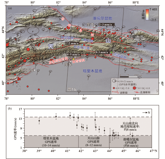
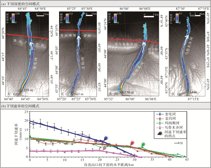
