Study progress of sandy coastal erosion
1
2009
... 我国海滩资源分布范围较广,沿海各省市均有分布,但分布极不均匀,有的沿海省市比较稀少,譬如江苏省、浙江省和上海市.随着全球海平面的上升以及人类活动的影响,原本脆弱不堪的海滩正在遭受缓慢持续的破坏,我国70%左右的海滩遭受侵蚀并出现不同程度的退化,这已成为海滩资源保护面临的一个普遍问题[1].为此,首先需要准确把握海滩系统的演变规律,而这依赖于可靠、连续和长期的测量数据. ...
砂质海岸侵蚀研究进展
1
2009
... 我国海滩资源分布范围较广,沿海各省市均有分布,但分布极不均匀,有的沿海省市比较稀少,譬如江苏省、浙江省和上海市.随着全球海平面的上升以及人类活动的影响,原本脆弱不堪的海滩正在遭受缓慢持续的破坏,我国70%左右的海滩遭受侵蚀并出现不同程度的退化,这已成为海滩资源保护面临的一个普遍问题[1].为此,首先需要准确把握海滩系统的演变规律,而这依赖于可靠、连续和长期的测量数据. ...
Nearshore real-time in situ video monitoring technique—The ARGUS system
2
2016
... 近20年来基于海岸线的近岸视频观测技术被成功引入到海岸带的野外监测研究领域.由于该技术具有实时、低成本、操作简单、适应性强、分辨率较高和可提供连续数据等优点,因此,近年来该技术发展迅速,研究应用领域逐渐扩大,全球海岸带监测体系也在不断构建完善,在海岸带的管理利用及保护、海岸工程实地研究和沿海防灾减灾等领域发挥着越来越重要的作用[2]. ...
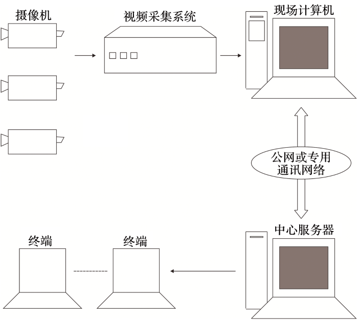
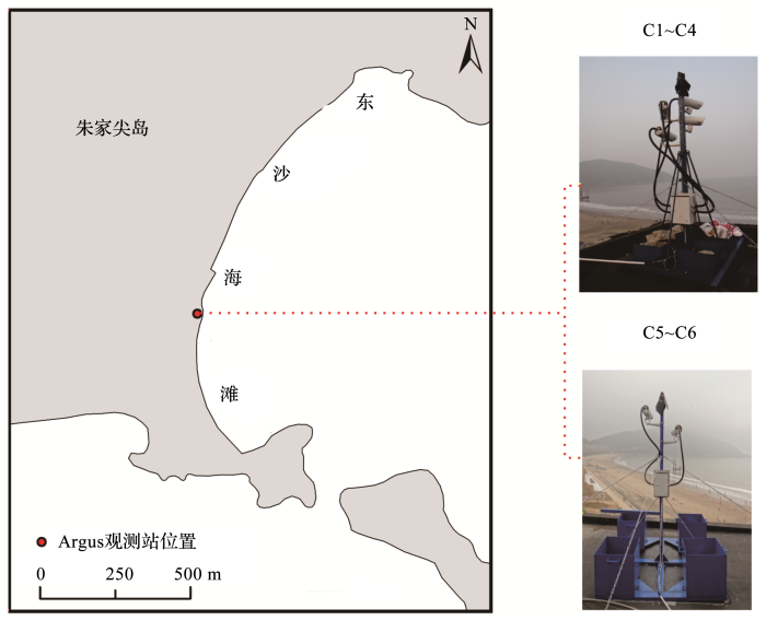
... Argus系统由硬件和后处理软件2个部分组成.其中硬件包括现场视频测站、专用通讯网络和中心服务器等(图1).现场视频测站的核心组件是摄像机,通常有4~6个,根据摄像机安置高度和相机镜头焦距,观测的空间范围可达3 km,能够实施从不到1秒到连续数年的自动化监测[2]. ...
海岸带实时实地视频观测ARGUS技术
2
2016
... 近20年来基于海岸线的近岸视频观测技术被成功引入到海岸带的野外监测研究领域.由于该技术具有实时、低成本、操作简单、适应性强、分辨率较高和可提供连续数据等优点,因此,近年来该技术发展迅速,研究应用领域逐渐扩大,全球海岸带监测体系也在不断构建完善,在海岸带的管理利用及保护、海岸工程实地研究和沿海防灾减灾等领域发挥着越来越重要的作用[2]. ...
... Argus系统由硬件和后处理软件2个部分组成.其中硬件包括现场视频测站、专用通讯网络和中心服务器等(图1).现场视频测站的核心组件是摄像机,通常有4~6个,根据摄像机安置高度和相机镜头焦距,观测的空间范围可达3 km,能够实施从不到1秒到连续数年的自动化监测[2]. ...
An introduction to nearshore video image observation
1
2006
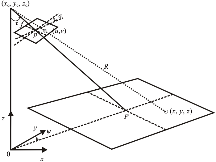
... Argus所采集的图像是二维的平面图像,而实际的海滩是三维的、立体的,为此需要建立起图像坐标(u,v)和真实坐标(x,y,z)之间位置的对应关系,即进行坐标转换[3](图2).这可以通过摄像机位置(xc,yc,zc)、有效焦距f和3个摄像机角度(倾角τ、方位角φ和滚动角σ)等参数来建立[4,5,6].角度τ,φ和σ分别是垂向上相对于z轴的旋转、水平方向上相对于xy平面的旋转以及焦平面相对于地平线的旋转.标准摄影测量方法可通过以下共线方程实现(x,y,z)到(u,v)的转换: ...
近海视频测量与应用
1
2006
... Argus所采集的图像是二维的平面图像,而实际的海滩是三维的、立体的,为此需要建立起图像坐标(u,v)和真实坐标(x,y,z)之间位置的对应关系,即进行坐标转换[3](图2).这可以通过摄像机位置(xc,yc,zc)、有效焦距f和3个摄像机角度(倾角τ、方位角φ和滚动角σ)等参数来建立[4,5,6].角度τ,φ和σ分别是垂向上相对于z轴的旋转、水平方向上相对于xy平面的旋转以及焦平面相对于地平线的旋转.标准摄影测量方法可通过以下共线方程实现(x,y,z)到(u,v)的转换: ...
Nearshore Bathymetry Derived from Video Imagery
4
2003
... Argus所采集的图像是二维的平面图像,而实际的海滩是三维的、立体的,为此需要建立起图像坐标(u,v)和真实坐标(x,y,z)之间位置的对应关系,即进行坐标转换[3](图2).这可以通过摄像机位置(xc,yc,zc)、有效焦距f和3个摄像机角度(倾角τ、方位角φ和滚动角σ)等参数来建立[4,5,6].角度τ,φ和σ分别是垂向上相对于z轴的旋转、水平方向上相对于xy平面的旋转以及焦平面相对于地平线的旋转.标准摄影测量方法可通过以下共线方程实现(x,y,z)到(u,v)的转换: ...
... [
4]
<strong>Schematic diagram of coordinate conversion principle</strong><sup>[<xref ref-type="bibr" rid="R4">4</xref>]</sup>Fig.2![]()
式中:系数L1~L11是7个未知量(τ, φ, σ),(xc, yc,zc)和f的线性函数.这7个未知量可以通过已知图像和现实世界坐标获取的一系列参考点[也称为地面控制点(Ground Control Points,GCP)]来确定.为此需要在硬件系统安装好后,测量海滩周边明显轮廓点以及滩面上一些点的地理坐标和高程.通过图像校正与坐标转换,将处理后所有摄像头的图像以一定的角度融合,就可以获得海滩的全景图与平面图. ...
... [
4]
Fig.2![]()
式中:系数L1~L11是7个未知量(τ, φ, σ),(xc, yc,zc)和f的线性函数.这7个未知量可以通过已知图像和现实世界坐标获取的一系列参考点[也称为地面控制点(Ground Control Points,GCP)]来确定.为此需要在硬件系统安装好后,测量海滩周边明显轮廓点以及滩面上一些点的地理坐标和高程.通过图像校正与坐标转换,将处理后所有摄像头的图像以一定的角度融合,就可以获得海滩的全景图与平面图. ...
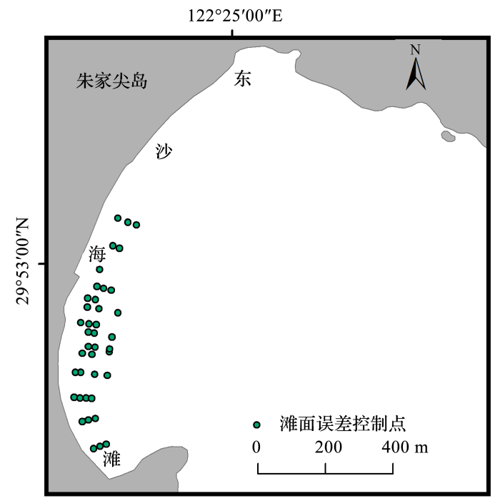
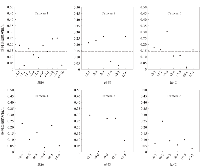
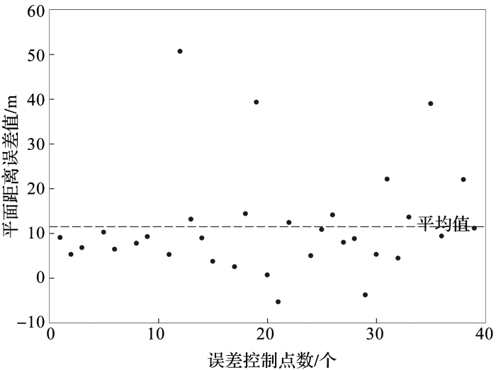
... 将RTK GPS滩面地形勘测点及Argus地形插值结果中对应点的高程进行比较,发现垂向平均相对误差为15%且误差全部分布在0.3 m以下(图9),6个摄像头(C1~C6)误差平均值为0.145 m,小于视频监测系统设计时的误差最大值0.25 m,这与很多已有研究的误差值相当[4,9,10,11,12,13].通过比较2个控制点之间的实测距离与Argus数据算得的2点距离可以测算平面距离误差(图10),得出平面距离误差平均值为11.73 m(剔除异常值),误差值主要集中在0~10 m,误差众数在允许范围(0.5~20 m)内[6].误差分布呈现出以下规律:离Argus观测站距离越近,垂向和平面误差越小;误差控制点之间的间距越大,平面距离误差越大. ...
Video estimation of foreshore topography using trinocular stereo
1
1997
... Argus所采集的图像是二维的平面图像,而实际的海滩是三维的、立体的,为此需要建立起图像坐标(u,v)和真实坐标(x,y,z)之间位置的对应关系,即进行坐标转换[3](图2).这可以通过摄像机位置(xc,yc,zc)、有效焦距f和3个摄像机角度(倾角τ、方位角φ和滚动角σ)等参数来建立[4,5,6].角度τ,φ和σ分别是垂向上相对于z轴的旋转、水平方向上相对于xy平面的旋转以及焦平面相对于地平线的旋转.标准摄影测量方法可通过以下共线方程实现(x,y,z)到(u,v)的转换: ...
Quantification of sand bar morphology: A video technique based on wave dissipation
8
1989
... Argus所采集的图像是二维的平面图像,而实际的海滩是三维的、立体的,为此需要建立起图像坐标(u,v)和真实坐标(x,y,z)之间位置的对应关系,即进行坐标转换[3](图2).这可以通过摄像机位置(xc,yc,zc)、有效焦距f和3个摄像机角度(倾角τ、方位角φ和滚动角σ)等参数来建立[4,5,6].角度τ,φ和σ分别是垂向上相对于z轴的旋转、水平方向上相对于xy平面的旋转以及焦平面相对于地平线的旋转.标准摄影测量方法可通过以下共线方程实现(x,y,z)到(u,v)的转换: ...
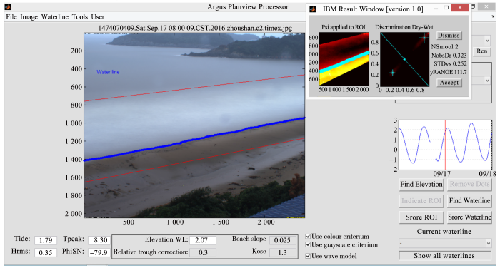
... IBM应用模块主要包含2个模型:水边线识别模型和水边线高程模型.前者的工作原理是根据图像颜色或亮度的独特强度值来区分干像素和湿像素的聚类.IBM将感兴趣区内的像素强度转换为处理颜色(色调和饱和度)和亮度信息的HSV(“Hue Saturation Value”)色彩空间(图4).其中色调范围介于0~1,从红色(色调= 0)经过橙色、黄色、绿色(色调= 0.5)、蓝色、紫色和再次回到红色(色调=1).对于黑色和白色,饱和度为0~1,对于主颜色(红、绿和蓝)和次颜色(青、品红和黄)采用值1.色彩值信息包含亮度级别,范围为0~1,0代表黑色,1代表白色.IBM水边线识别首先是在兴趣区(Region Of Interest, ROI)内进行像素强度值采样,然后在色相饱和空间中对这些强度进行分类,进而对原始像素强度进行滤波以去除异常值,并在0~1进行缩放以改善干燥和湿润像素群之间的对比度[6]. ...
... [
6]
<strong>HSV color space </strong><sup>[<xref ref-type="bibr" rid="R6">6</xref>]</sup>Fig.4![]()
由于Argus系统中的IBM模型旨在从时均图像中识别水边线的位置,因此IBM高程模型必须考虑在平均时间内影响水边线瞬时位置的所有物理过程,即潮位、风生或浪生增水、破波引起的波增水和漩涡振荡等.水边线高程Z0受参考水位Zref以上的潮汐变化ΔZtide、风暴潮引起增加的水位ΔZstorm以及局部风增水ΔZwind的共同影响,公式如下: ...
... [
6]
Fig.4![]()
由于Argus系统中的IBM模型旨在从时均图像中识别水边线的位置,因此IBM高程模型必须考虑在平均时间内影响水边线瞬时位置的所有物理过程,即潮位、风生或浪生增水、破波引起的波增水和漩涡振荡等.水边线高程Z0受参考水位Zref以上的潮汐变化ΔZtide、风暴潮引起增加的水位ΔZstorm以及局部风增水ΔZwind的共同影响,公式如下: ...
... 水边线的高程最好采用在野外测站或感兴趣区10 km内的测量水位数据,以估算ΔZtide和ΔZstorm的贡献量.如果没有本地测量的水位数据,ΔZtide和ΔZstorm也可以通过潮汐和风暴潮模型计算出来[6]. ...
... 将RTK GPS滩面地形勘测点及Argus地形插值结果中对应点的高程进行比较,发现垂向平均相对误差为15%且误差全部分布在0.3 m以下(图9),6个摄像头(C1~C6)误差平均值为0.145 m,小于视频监测系统设计时的误差最大值0.25 m,这与很多已有研究的误差值相当[4,9,10,11,12,13].通过比较2个控制点之间的实测距离与Argus数据算得的2点距离可以测算平面距离误差(图10),得出平面距离误差平均值为11.73 m(剔除异常值),误差值主要集中在0~10 m,误差众数在允许范围(0.5~20 m)内[6].误差分布呈现出以下规律:离Argus观测站距离越近,垂向和平面误差越小;误差控制点之间的间距越大,平面距离误差越大. ...
... Argus视频监测系统非常适合于海滩养护工程前后地形地貌变化的连续监测,以评估海滩养护后的演化效果[6,9,14,15,16],比如Ruessink等[16]在荷兰的Noordwijk海滩利用Argus获得长达16年的数据,研究了在不同年代进行的养护前后海滩近滨的演化过程. ...
... 对Argus图像进行分析可以得到近岸波浪信息,如波浪周期、波向、波速、波谱等,进而借助相关波浪理论就可以反演近岸水深地形[6,19,20,21,22].如Stockdon等[19]通过从图像中提取向岸传播的波浪速率与波数,利用线性波理论推算了近岸水深,结果显示与实测水深之间的均方根误差为34%;后来,Bergsma等[22]对存在的相机边界与大潮期间显著不精确问题进行改进后,均方根误差减少到了10%.虽然不像传统测量技术那样精确,但视频方法具有价格低廉、逻辑简单、不受恶劣天气影响的特性,并且可以长时间频繁地采样,而不需要额外的成本(除了自动分析之外). ...
Preliminary Application of Argus in the Topography Evolution of Dongsha Beach
1
2017
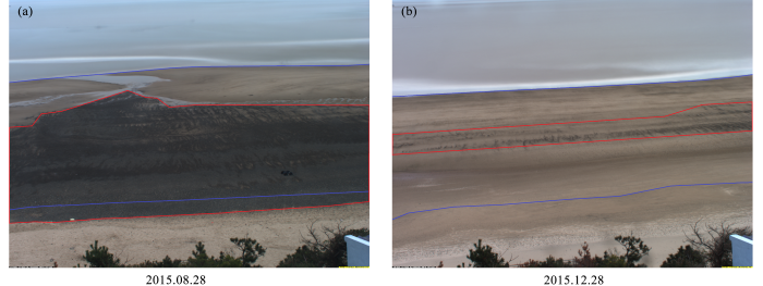
... 在东沙海滩的应用研究中,李源[7]利用2015年5月至2016年4月之间的Argus图像数据,对比分析了东沙海滩不同季节和台风“灿鸿”前后的地形地貌变化特征,重点指出了滩面上砾石带分布的变化情况(图6). ...
Argus在东沙海滩地形地貌演变中的初步应用
1
2017
... 在东沙海滩的应用研究中,李源[7]利用2015年5月至2016年4月之间的Argus图像数据,对比分析了东沙海滩不同季节和台风“灿鸿”前后的地形地貌变化特征,重点指出了滩面上砾石带分布的变化情况(图6). ...
Beach Response to Continuous Storms Using Argus Monitoring Data: A Case Study of Dongsha Beach in Zhoushan
1
2018
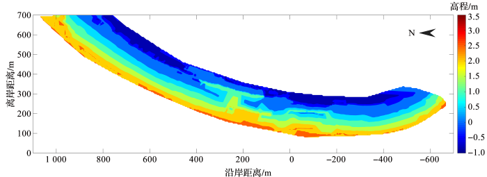
... 郭俊丽[8]以2016年的Argus视频图像数据为基础,结合东沙海滩近岸波浪、潮位、风等动力数据,借助Argus应用模块得到了东沙海滩滩面地形数据(图7).进而从海滩地貌、剖面、海滩滨线和海滩宽度等方面定量分析了海滩对连续风暴“马勒卡”和“暹芭”的响应特征,获得以下主要结论: ...
基于Argus监测数据的海滩对连续风暴的响应——以舟山东沙海滩为例
1
2018
... 郭俊丽[8]以2016年的Argus视频图像数据为基础,结合东沙海滩近岸波浪、潮位、风等动力数据,借助Argus应用模块得到了东沙海滩滩面地形数据(图7).进而从海滩地貌、剖面、海滩滨线和海滩宽度等方面定量分析了海滩对连续风暴“马勒卡”和“暹芭”的响应特征,获得以下主要结论: ...
Quantifying the rapid erosion of a nourishment project with video imagery
2
2005
... 将RTK GPS滩面地形勘测点及Argus地形插值结果中对应点的高程进行比较,发现垂向平均相对误差为15%且误差全部分布在0.3 m以下(图9),6个摄像头(C1~C6)误差平均值为0.145 m,小于视频监测系统设计时的误差最大值0.25 m,这与很多已有研究的误差值相当[4,9,10,11,12,13].通过比较2个控制点之间的实测距离与Argus数据算得的2点距离可以测算平面距离误差(图10),得出平面距离误差平均值为11.73 m(剔除异常值),误差值主要集中在0~10 m,误差众数在允许范围(0.5~20 m)内[6].误差分布呈现出以下规律:离Argus观测站距离越近,垂向和平面误差越小;误差控制点之间的间距越大,平面距离误差越大. ...
... Argus视频监测系统非常适合于海滩养护工程前后地形地貌变化的连续监测,以评估海滩养护后的演化效果[6,9,14,15,16],比如Ruessink等[16]在荷兰的Noordwijk海滩利用Argus获得长达16年的数据,研究了在不同年代进行的养护前后海滩近滨的演化过程. ...
Coupling video imaging and numerical modelling for the study of inlet morphodynamics
1
2007
... 将RTK GPS滩面地形勘测点及Argus地形插值结果中对应点的高程进行比较,发现垂向平均相对误差为15%且误差全部分布在0.3 m以下(图9),6个摄像头(C1~C6)误差平均值为0.145 m,小于视频监测系统设计时的误差最大值0.25 m,这与很多已有研究的误差值相当[4,9,10,11,12,13].通过比较2个控制点之间的实测距离与Argus数据算得的2点距离可以测算平面距离误差(图10),得出平面距离误差平均值为11.73 m(剔除异常值),误差值主要集中在0~10 m,误差众数在允许范围(0.5~20 m)内[6].误差分布呈现出以下规律:离Argus观测站距离越近,垂向和平面误差越小;误差控制点之间的间距越大,平面距离误差越大. ...
Improving accuracy and statistical reliability of shoreline position and change rate estimates
1
2009
... 将RTK GPS滩面地形勘测点及Argus地形插值结果中对应点的高程进行比较,发现垂向平均相对误差为15%且误差全部分布在0.3 m以下(图9),6个摄像头(C1~C6)误差平均值为0.145 m,小于视频监测系统设计时的误差最大值0.25 m,这与很多已有研究的误差值相当[4,9,10,11,12,13].通过比较2个控制点之间的实测距离与Argus数据算得的2点距离可以测算平面距离误差(图10),得出平面距离误差平均值为11.73 m(剔除异常值),误差值主要集中在0~10 m,误差众数在允许范围(0.5~20 m)内[6].误差分布呈现出以下规律:离Argus观测站距离越近,垂向和平面误差越小;误差控制点之间的间距越大,平面距离误差越大. ...
Storm response and beach rotation on a gravel beach, Slapton Sands, UK
1
2010
... 将RTK GPS滩面地形勘测点及Argus地形插值结果中对应点的高程进行比较,发现垂向平均相对误差为15%且误差全部分布在0.3 m以下(图9),6个摄像头(C1~C6)误差平均值为0.145 m,小于视频监测系统设计时的误差最大值0.25 m,这与很多已有研究的误差值相当[4,9,10,11,12,13].通过比较2个控制点之间的实测距离与Argus数据算得的2点距离可以测算平面距离误差(图10),得出平面距离误差平均值为11.73 m(剔除异常值),误差值主要集中在0~10 m,误差众数在允许范围(0.5~20 m)内[6].误差分布呈现出以下规律:离Argus观测站距离越近,垂向和平面误差越小;误差控制点之间的间距越大,平面距离误差越大. ...
Optimal index related to the shoreline dynamics during a storm: The case of Jesolo beach
1
2015
... 将RTK GPS滩面地形勘测点及Argus地形插值结果中对应点的高程进行比较,发现垂向平均相对误差为15%且误差全部分布在0.3 m以下(图9),6个摄像头(C1~C6)误差平均值为0.145 m,小于视频监测系统设计时的误差最大值0.25 m,这与很多已有研究的误差值相当[4,9,10,11,12,13].通过比较2个控制点之间的实测距离与Argus数据算得的2点距离可以测算平面距离误差(图10),得出平面距离误差平均值为11.73 m(剔除异常值),误差值主要集中在0~10 m,误差众数在允许范围(0.5~20 m)内[6].误差分布呈现出以下规律:离Argus观测站距离越近,垂向和平面误差越小;误差控制点之间的间距越大,平面距离误差越大. ...
Morphodynamic response of nearshore bars to a shoreface nourishment
1
2005
... Argus视频监测系统非常适合于海滩养护工程前后地形地貌变化的连续监测,以评估海滩养护后的演化效果[6,9,14,15,16],比如Ruessink等[16]在荷兰的Noordwijk海滩利用Argus获得长达16年的数据,研究了在不同年代进行的养护前后海滩近滨的演化过程. ...
Beach nourishments at Coolangatta Bay over the period 1987-2005: Impacts and lessons
1
2009
... Argus视频监测系统非常适合于海滩养护工程前后地形地貌变化的连续监测,以评估海滩养护后的演化效果[6,9,14,15,16],比如Ruessink等[16]在荷兰的Noordwijk海滩利用Argus获得长达16年的数据,研究了在不同年代进行的养护前后海滩近滨的演化过程. ...
Crossing Borders in Coastal Research, Jubilee Conference Proceedings, 20th NCK-days
2
2012
... Argus视频监测系统非常适合于海滩养护工程前后地形地貌变化的连续监测,以评估海滩养护后的演化效果[6,9,14,15,16],比如Ruessink等[16]在荷兰的Noordwijk海滩利用Argus获得长达16年的数据,研究了在不同年代进行的养护前后海滩近滨的演化过程. ...
... [16]在荷兰的Noordwijk海滩利用Argus获得长达16年的数据,研究了在不同年代进行的养护前后海滩近滨的演化过程. ...
Wave run-up observation and 2DV numerical investigation on beaches protected by structures
1
2012
... 基于Argus视频监测技术,通过定量波浪爬高与滩面沉积物的侵淤量,可以评价海岸工程建筑物对海滩地形的影响,例如:Archetti等[17]通过从Argus图像中提取波浪爬高数据,结合数值模拟,分析了近岸潜堤对海滩的影响;Sancho-García等[18]利用Argus视频图像数据,研究了西班牙巴塞罗那沿岸3个岬湾型海滩在防波堤建设后对风暴的响应特征. ...
Storm-induced readjustment of an embayed beach after modification by protection works
1
2013
... 基于Argus视频监测技术,通过定量波浪爬高与滩面沉积物的侵淤量,可以评价海岸工程建筑物对海滩地形的影响,例如:Archetti等[17]通过从Argus图像中提取波浪爬高数据,结合数值模拟,分析了近岸潜堤对海滩的影响;Sancho-García等[18]利用Argus视频图像数据,研究了西班牙巴塞罗那沿岸3个岬湾型海滩在防波堤建设后对风暴的响应特征. ...
Estimation of wave phase speed and nearshore bathymetry from video imagery
2
2000
... 对Argus图像进行分析可以得到近岸波浪信息,如波浪周期、波向、波速、波谱等,进而借助相关波浪理论就可以反演近岸水深地形[6,19,20,21,22].如Stockdon等[19]通过从图像中提取向岸传播的波浪速率与波数,利用线性波理论推算了近岸水深,结果显示与实测水深之间的均方根误差为34%;后来,Bergsma等[22]对存在的相机边界与大潮期间显著不精确问题进行改进后,均方根误差减少到了10%.虽然不像传统测量技术那样精确,但视频方法具有价格低廉、逻辑简单、不受恶劣天气影响的特性,并且可以长时间频繁地采样,而不需要额外的成本(除了自动分析之外). ...
... [19]通过从图像中提取向岸传播的波浪速率与波数,利用线性波理论推算了近岸水深,结果显示与实测水深之间的均方根误差为34%;后来,Bergsma等[22]对存在的相机边界与大潮期间显著不精确问题进行改进后,均方根误差减少到了10%.虽然不像传统测量技术那样精确,但视频方法具有价格低廉、逻辑简单、不受恶劣天气影响的特性,并且可以长时间频繁地采样,而不需要额外的成本(除了自动分析之外). ...
Remote Measurements of Waves and Currents Over Complex Bathymetry
1
2007
... 对Argus图像进行分析可以得到近岸波浪信息,如波浪周期、波向、波速、波谱等,进而借助相关波浪理论就可以反演近岸水深地形[6,19,20,21,22].如Stockdon等[19]通过从图像中提取向岸传播的波浪速率与波数,利用线性波理论推算了近岸水深,结果显示与实测水深之间的均方根误差为34%;后来,Bergsma等[22]对存在的相机边界与大潮期间显著不精确问题进行改进后,均方根误差减少到了10%.虽然不像传统测量技术那样精确,但视频方法具有价格低廉、逻辑简单、不受恶劣天气影响的特性,并且可以长时间频繁地采样,而不需要额外的成本(除了自动分析之外). ...
Response of high-energy, macrotidal beaches to seasonal changes in wave conditions: Examples from North Cornwall, UK
1
2009
... 对Argus图像进行分析可以得到近岸波浪信息,如波浪周期、波向、波速、波谱等,进而借助相关波浪理论就可以反演近岸水深地形[6,19,20,21,22].如Stockdon等[19]通过从图像中提取向岸传播的波浪速率与波数,利用线性波理论推算了近岸水深,结果显示与实测水深之间的均方根误差为34%;后来,Bergsma等[22]对存在的相机边界与大潮期间显著不精确问题进行改进后,均方根误差减少到了10%.虽然不像传统测量技术那样精确,但视频方法具有价格低廉、逻辑简单、不受恶劣天气影响的特性,并且可以长时间频繁地采样,而不需要额外的成本(除了自动分析之外). ...
Video-based nearshore bathymetry estimation in macro-tidal environments
2
2016
... 对Argus图像进行分析可以得到近岸波浪信息,如波浪周期、波向、波速、波谱等,进而借助相关波浪理论就可以反演近岸水深地形[6,19,20,21,22].如Stockdon等[19]通过从图像中提取向岸传播的波浪速率与波数,利用线性波理论推算了近岸水深,结果显示与实测水深之间的均方根误差为34%;后来,Bergsma等[22]对存在的相机边界与大潮期间显著不精确问题进行改进后,均方根误差减少到了10%.虽然不像传统测量技术那样精确,但视频方法具有价格低廉、逻辑简单、不受恶劣天气影响的特性,并且可以长时间频繁地采样,而不需要额外的成本(除了自动分析之外). ...
... [22]对存在的相机边界与大潮期间显著不精确问题进行改进后,均方根误差减少到了10%.虽然不像传统测量技术那样精确,但视频方法具有价格低廉、逻辑简单、不受恶劣天气影响的特性,并且可以长时间频繁地采样,而不需要额外的成本(除了自动分析之外). ...
Daily to Yearly Nearshore Bar Behaviour
2
2001
... 有了近岸地形数据,就可以开展近岸沙坝演变方面的研究[23,24,25],如:Van Enckevort[23]基于Argus图像数据,分析了荷兰Noordwijk近岸沙坝在从天到年不同时间尺度上的变化特征. ...
... [23]基于Argus图像数据,分析了荷兰Noordwijk近岸沙坝在从天到年不同时间尺度上的变化特征. ...
Dynamics of a nearshore bar system in the northern Adriatic: A video-based morphological classification
1
2011
... 有了近岸地形数据,就可以开展近岸沙坝演变方面的研究[23,24,25],如:Van Enckevort[23]基于Argus图像数据,分析了荷兰Noordwijk近岸沙坝在从天到年不同时间尺度上的变化特征. ...
Response of wave-dominated and mixed-energy barriers to storms
1
2014
... 有了近岸地形数据,就可以开展近岸沙坝演变方面的研究[23,24,25],如:Van Enckevort[23]基于Argus图像数据,分析了荷兰Noordwijk近岸沙坝在从天到年不同时间尺度上的变化特征. ...
Temporal observations of rip current circulation on a macro-tidal beach
1
2010
... Argus视频监测系统也可用于裂流监测.裂流是导致海滩溺水事故发生的主要原因,但对裂流的现场监测与识别一直以来都是一个比较棘手的难题.近年来,调查人员大多采用高浓度粉末状或液态染料制成的示踪剂或带有GPS定位的浮子来监测裂流,在监测过程中,Argus系统发挥了重要作用[26,27,28,29].其中,Prodger[27]利用2006—2012年的Argus数据集,研究了英国Perranporth海滩不同波浪和潮位条件下裂流的发生、发展和持续性. ...
Argus Observations of Rip Current Variability Along a Macro-tidal Beach
2
2012
... Argus视频监测系统也可用于裂流监测.裂流是导致海滩溺水事故发生的主要原因,但对裂流的现场监测与识别一直以来都是一个比较棘手的难题.近年来,调查人员大多采用高浓度粉末状或液态染料制成的示踪剂或带有GPS定位的浮子来监测裂流,在监测过程中,Argus系统发挥了重要作用[26,27,28,29].其中,Prodger[27]利用2006—2012年的Argus数据集,研究了英国Perranporth海滩不同波浪和潮位条件下裂流的发生、发展和持续性. ...
... [27]利用2006—2012年的Argus数据集,研究了英国Perranporth海滩不同波浪和潮位条件下裂流的发生、发展和持续性. ...
Controls on macrotidal rip current circulation and hazard
1
2014
... Argus视频监测系统也可用于裂流监测.裂流是导致海滩溺水事故发生的主要原因,但对裂流的现场监测与识别一直以来都是一个比较棘手的难题.近年来,调查人员大多采用高浓度粉末状或液态染料制成的示踪剂或带有GPS定位的浮子来监测裂流,在监测过程中,Argus系统发挥了重要作用[26,27,28,29].其中,Prodger[27]利用2006—2012年的Argus数据集,研究了英国Perranporth海滩不同波浪和潮位条件下裂流的发生、发展和持续性. ...
Dynamics of rip currents associated with groynes—Field measurements, modelling and implications for beach safety
1
2016
... Argus视频监测系统也可用于裂流监测.裂流是导致海滩溺水事故发生的主要原因,但对裂流的现场监测与识别一直以来都是一个比较棘手的难题.近年来,调查人员大多采用高浓度粉末状或液态染料制成的示踪剂或带有GPS定位的浮子来监测裂流,在监测过程中,Argus系统发挥了重要作用[26,27,28,29].其中,Prodger[27]利用2006—2012年的Argus数据集,研究了英国Perranporth海滩不同波浪和潮位条件下裂流的发生、发展和持续性. ...
Technical Development and Methodologies Based on Video Systems for the Management of the Coast
1
2005
... 随着Argus观测系统技术的不断提高和日益完善,国际上越来越多的研究人员将其用于海滩旅游管理方面,诸多研究结果也表明,基于Argus的视频监测方法是获得游客时空分布特征的一个有效手段,具有传统方法所没有的诸多明显优势[30,31,32,33].如Balouin等[33]基于Argus视频监测图像数据,提出了一种新的自动定量分析海滩用户数量和位置的方法,并将其用于法国Sète海滩Lido段2012年用户的时空分布模式分析中,进而探讨了分布模式与现场环境、气象、社会等参数的关系.可以预见,基于Argus视频图像的监测技术将成为海滩游客时空分布研究最重要的手段,也势必会得到越来越广泛的应用. ...
Beach recreation planning using video-derived coastal state indicators
1
2007
... 随着Argus观测系统技术的不断提高和日益完善,国际上越来越多的研究人员将其用于海滩旅游管理方面,诸多研究结果也表明,基于Argus的视频监测方法是获得游客时空分布特征的一个有效手段,具有传统方法所没有的诸多明显优势[30,31,32,33].如Balouin等[33]基于Argus视频监测图像数据,提出了一种新的自动定量分析海滩用户数量和位置的方法,并将其用于法国Sète海滩Lido段2012年用户的时空分布模式分析中,进而探讨了分布模式与现场环境、气象、社会等参数的关系.可以预见,基于Argus视频图像的监测技术将成为海滩游客时空分布研究最重要的手段,也势必会得到越来越广泛的应用. ...
Long-term quantification of beach users using video monitoring
1
2008
... 随着Argus观测系统技术的不断提高和日益完善,国际上越来越多的研究人员将其用于海滩旅游管理方面,诸多研究结果也表明,基于Argus的视频监测方法是获得游客时空分布特征的一个有效手段,具有传统方法所没有的诸多明显优势[30,31,32,33].如Balouin等[33]基于Argus视频监测图像数据,提出了一种新的自动定量分析海滩用户数量和位置的方法,并将其用于法国Sète海滩Lido段2012年用户的时空分布模式分析中,进而探讨了分布模式与现场环境、气象、社会等参数的关系.可以预见,基于Argus视频图像的监测技术将成为海滩游客时空分布研究最重要的手段,也势必会得到越来越广泛的应用. ...
Automatic assessment and analysis of beach attendance using video images at the lido of Sète Beach, France
2
2014
... 随着Argus观测系统技术的不断提高和日益完善,国际上越来越多的研究人员将其用于海滩旅游管理方面,诸多研究结果也表明,基于Argus的视频监测方法是获得游客时空分布特征的一个有效手段,具有传统方法所没有的诸多明显优势[30,31,32,33].如Balouin等[33]基于Argus视频监测图像数据,提出了一种新的自动定量分析海滩用户数量和位置的方法,并将其用于法国Sète海滩Lido段2012年用户的时空分布模式分析中,进而探讨了分布模式与现场环境、气象、社会等参数的关系.可以预见,基于Argus视频图像的监测技术将成为海滩游客时空分布研究最重要的手段,也势必会得到越来越广泛的应用. ...
... [33]基于Argus视频监测图像数据,提出了一种新的自动定量分析海滩用户数量和位置的方法,并将其用于法国Sète海滩Lido段2012年用户的时空分布模式分析中,进而探讨了分布模式与现场环境、气象、社会等参数的关系.可以预见,基于Argus视频图像的监测技术将成为海滩游客时空分布研究最重要的手段,也势必会得到越来越广泛的应用. ...
Coastline sand waves on a low-energy beach at “EI Puntal” spit, Spain
1
2008
... 河口沙嘴位于河海交汇地带,既受入海水沙的影响,又受近岸波流作用,冲淤变化比较频繁.特别是在遭受洪水或风暴潮的情况下,短时间内就会发生剧烈变化,而传统的测量方法很难捕捉到这种变化,Argus视频监测系统正好可以解决这一难题.比如,Medellín等[34]从2003年就开始用Argus对西班牙EI Puntal沙嘴的沙波进行监测与研究;Liu等[35]对日本天龙川入海河口处的沙洲进行视频观测,记录了2009年10月台风所造成的波浪越波现象和台风之后沙洲的自我恢复过程. ...
Long-term monitoring on the sand spit morphodynamics at the Tenryu River Mouth
1
2010
... 河口沙嘴位于河海交汇地带,既受入海水沙的影响,又受近岸波流作用,冲淤变化比较频繁.特别是在遭受洪水或风暴潮的情况下,短时间内就会发生剧烈变化,而传统的测量方法很难捕捉到这种变化,Argus视频监测系统正好可以解决这一难题.比如,Medellín等[34]从2003年就开始用Argus对西班牙EI Puntal沙嘴的沙波进行监测与研究;Liu等[35]对日本天龙川入海河口处的沙洲进行视频观测,记录了2009年10月台风所造成的波浪越波现象和台风之后沙洲的自我恢复过程. ...


