First author:Gu Jiawei(1981-),male,Zhengzhou City,He’nan Province,Associate professor. Research areas include Quaternary research in the Yangtze Delta.E-mail:15939018661@163.com
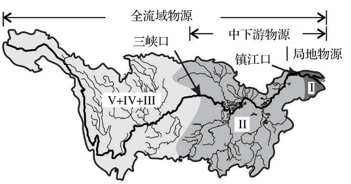
This study investigated sediment source to sink relating the channelization of the Yangtze River into the sea. A sediment borehole (PD) on the river coast, penetrating thick Quaternary sediments, to thin sediments of late Pliocene age until the bedrock recorded a change in sediment provenances through time. Geochemical elements and magneto-stratigraphy helped identify five zones. Zone I (the late Pliocene-the Early Pleistocene), characterized by Pb, Th, U, Ba, La, Ce, Nd, Hf, Y, Zr, Nb and Mn, indicated a local sediment provenance. This means that the study area was a localized sub-basin. Zone II (the Early Pleistocene-the mid-stage of Early Pleistocene), with remarkable high Fe, K, As and Rb implied a new sediment provenance joining to the sub-basin from the middle Yangtze reach after the opening of Zhenjiang Gorge. Zone III (the mid-stage of Early Pleistocene-the Middle Pleistocene), featured by Ti, V, Cr, Sr, Sc, Cu, Co, Ni, Mg, Ca, Na and P suggested a further extension of sediment provenance to the upper Yangtze reach, where a large block of the E’mei basalt occurs. This hinted the channelization of the Three Gorges valley linking the upper and middle Yangtze reaches. Zone IV~V (the Middle Pleistocene-the Holocene) showed their geochemical similarity to Zone III. Discrimination ratio f(Cr,Th), f(La) and f(K,La), a new approach developed for tracing sediment provenance, confirmed a basin-wide sediment source through Zone III-V. These together witness a progressive extension of the sediment provenance towards the upper Yangtze reach, corresponding to the long-term tilting effect of the Cenozoic Topographic Reversal of the eastern China continent. The timing of the Yangtze River channelizing into the continental shelf of East Asia appeared at ca. 1.0~1.2 Ma (bottom of Zone III).
Keywords:Elemental composition
;
River channelization
;
Plio-Quaternary sediments
;
The Yangtze River.
GuJiawei. Geochemical Finger Prints on China’s Yangtze River Channelization into the Sea and Its Provenance Implications[J]. Advances in Earth Science, 2018, 33(5): 506-516 https://doi.org/10.11867/j.issn.1001-8166.2018.05.0506
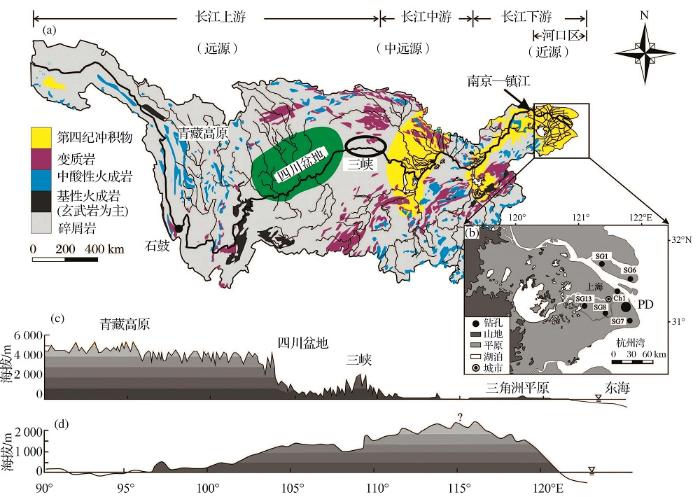
Fig.1 Geological and geomorphological details of the Yangtze drainage basin (a) Source rocks in the Yangtze Basin(modified after reference[3]); (b) The Yangtze Estuary and the sediment boreholes; (c) Cenozoic topographic reversal geomorphologic profile at present in the eastern China coast; (d) Cenozoic topographic reversal geomorphologic profile during the Early Tertiary(modified after reference[4])
Fig.3 Generalized Plio-Quaternary magneto-stratigraphy of the Yangtze Delta (modified after reference[49]) Gray bar marks lower magnetic susceptibility in the bottom of cores
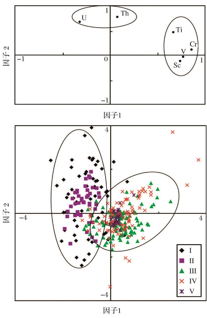
Fig.4 Q-type cluster plot of PD bore and its geochemical distribution (a) Consists of Ti, V, Cr and other elemental distribution; (b) Consists of Th, U and other elemental distribution, and three discrimination ratios; All elements are normalized by Al; The vertical dashed line denotes the mean values; Bold lines in discrimination ratios are ten points moving average; Five zones of I~V are established by cluster analysis of TILIA
Fig.5 Factor analysis for the diagnostic elements and the loading distribution of samples in the PD core (a) Factor analysis for the diagnostic elements of Ti,V,Cr,Sc, Th and U in PD core; (b) The loading of the diagnostic elements of PD core on F1 and F2
Diagnostic heavy minerals in Plio-Pleistocene sediments of the Yangtze Coast, China with special reference to the Yangtze River connection into the sea
This present study revealed five heavy mineral zones in the Yangtze coastal borehole sediments. Ilmenite, garnet and zircon suite of Zone I of the Pliocene characterizes the derivation of basaltic bedrock and local andesitic–granitic rocks. Indicative limonite in the Zone I sediments formed as alluvial fan facies shows strong chemical weathering. The assemblage of amphibole, straurolite, kyanite and idocrase of metamorphic derivation, together with a few zircon and tourmaline of andesitic–granitic origin in Zone II, represents the extension of sediment sources to the lower and middle Yangtze basin in Early Pleistocene as the study area subsided. Also, the braided to meandering riverine facies demonstrates a longer distance sediment transport. Few heavy minerals remained in Zone III of Mid-Pleistocene, when mottled thicker stiff mud occurred as the lacustrine facies, suggesting a quasi-coastal floodplain with lower capability of sediment transport. Heavy minerals appeared significant and continuous in Zone IV of Late Pleistocene, when changing to the shallow marine facies, inferring much extended sediment sources to the upper Yangtze. Hypersthene, identified primarily in Zone IV, was closely associated with the Er-Mei Mountain tholeiite basalt of the upper Yangtze. Heavy minerals of Zone V remained almost the same as IV during Holocene, when the modern delta evolved. The heavy minerals suggested the timing of the Yangtze connection to the sea at ca 0.1202Ma BP.
[2]
Clift PD, ShimizuN, Layne GD, et al.
Development of the Indus Fan and its significance for the erosional history of the Western Himalaya and Karakoram
[J]. Geological Society of America, 2001, 113(8): 1 039-1 051.
Correlation of new multichannel seismic profiles across the upper Indus Fan and Murray Ridge with a dated industrial well on the Pakistan shelf demonstrates that similar to 40% of the Indus Fan predates the middle Miocene, and similar to 35% predates uplift of the Murray Ridge (early Miocene, similar to 22 Ma). The Arabian Sea, in addition to the Makran accretionary complex, was therefore an important repository of sediment from the Indus River system during the Paleogene. Channel and levee complexes are most pronounced after the early Miocene, coincident with an increase in sedimentation rates. Middle Eocene sandstones from Deep Sea Drilling Project Site 224 an the Owen Ridge yield K-feldspars whose Pb isotopic composition, measured by in situ ion microprobe methods, indicates an origin in, or north of, the Indus suture zone. This observation requires that India-Asia collision had occurred by this time and that an Indus River system, feeding material from the suture zone into the basin, was active soon after collision. Pleistocene provenance was similar to that during the Eocene, albeit with greater contribution from the Karakoram. A mass balance of the erosional record on land with deposition in the fan and associated basins suggests that only similar to 40% of the Neogene sediment in the fan is derived from the Indian plate.
[3]
Changjiang River Water Resources Commission. Atlas of Changjiang River Basin[M]. Beijing:Sinomaps Press, 1999.
Neogene deposits are widely distributed in north and west China, whereas in southeast China they are confined to isolated basins. The Neogene in China is predominated by non-marine facies and marine deposits are limited to the Leizhou Peninsula, some islands and continental shelves, although Miocene brackish-water deposits were encountered in Xinjiang, northwest China, and a very brief marine transgression took place in north China near the end of the Pliocene. Non-marine Neogene deposits in China are largely fluvial and lacustrine in origin and composed of mudstones, sandstones and conglomerates with local occurrences of lignites and diatomites. The maximum thickness may exceed 2000 m (e.g. the Qaidam Basin). A rich fauna and flora have been found in many localities and the most famous are the Middle Miocene diatomites at Shanwang, Shandong Province, with unusually well preserved vertebrate and plant fossils. A total of 7 mammal stages have been distinguished in China (5 in the Miocene, 2 in the Pliocene) and tentatively correlated with the European stages. A major realignment of climatic zones occurred before the Paleogene/Neogene boundary, when the Paleogene climatic zones, with a NW-trending broad arid zone across the whole of China, was eliminated and the arid zone moved to northwest China, presumably indicating the onset of the monsoon circulation system. During the last few years, the marine Neogene has been intensively studied in the Leizhou Peninsula and the three major sedimentary basins off the south China coast: the Beibu Gulf (Gulf of Tonkin) Basin, the Zhujiangkou (Pearl River mouth) Basin and the Yinggehai Basin. This sequence is over 3000 m thick, ranges from the Oligocene to the Pleistocene and consists of grey mudstones, sandstones and conglomerates, interbedded with biogenic deposits such as reef limestones and sandy chalk. At least 6 foraminiferal assemblages can be recognized in the three basins: the Psudohastigerina micra assemblage from the Oligocene, the Globigerina ciperoensis-Cassigerinella chipolensis assemblage from the Lower Miocene, the Globoratalia siakensis-Orbulina suturalis assemblage from the Middle Miocene, the Globigerina nepenthes-Globorotalia acostaensis assemblage from the Upper Miocene and/or Lower Plicoene, the Globorotalia tosaensis- Globigerinoides extremus assemblage from the Upper Pliocene and the Globorotalia truncatulinoides assemblage from the Quaternary. The nannofossil succession and larger foraminiferal faunas confirm the ages. The tropical nature of the Neogene faunas is revealed by the occurrences of large foraminifers and warm-water species of other groups. The transgression cycles are controlled by tectonic processes during the Oligocene and Early Miocene, but later by eustatic movements.
[5]
LiSiguang.
Geology of the gorge district of the Yangtze (from Ichang to Tzekuei) with special reference to the development of the gorges
[J]. Bulletin of the Geological Society of China, 1924, 3(3/4): 351-391.
During uplift of the Tibetan plateau and surrounding ranges, tectonic processes have interacted with climatic change and with local random effects (such as landslides) to determine the development of the major river systems of Asia. Rivers draining southward have three distinctive patterns that are controlled by different tectonic and climatic regimes. In central and southern Afghanistan, the rivers have moderate gradients and fan out from northeastern sources to disappear into arid depressions. Anti-clockwise rotation of southern Afghanistan, caused by differential compression and right-lateral shear, cut the rivers on the north, while increasingly arid conditions developed on the south as arc accretion in the Makran separated sources from the coastal rains. In Tibet and southeast Asia, the rivers are widely separated and have low gradients on the Tibetan plateau, higher gradients as they turn southwards into close and parallel gorges, before they fan out southeast to enter different seas. Differential shear and clockwise rotation between the compressing Tibetan plateau and Southeast Asia determined the great sigmoidal bends of this river system which was accompanied by increasing aridity, with truncation of river systems in the north and river capture in the south. In the Himalaya and southern Tibet, the main rivers have steep gradients where they cut across the Himalayan range and occasionally truncate former rivers with low gradients on the Tibetan plateau to the north. Southward thrusting and massive frontal erosion of the Himalaya caused progressive truncation of longitudinal rivers on the plateau, accompanied by river capture, and glacial and landslide diversions on the south. The drainage history of southern Asia can be reconstructed by restoring the gross movements of the plates and the tectonic displacement, uplift, and erosion of individual tectonic units. Most important changes in drainage took place in Pliocene to Quaternary times.
[12]
Clark MK, Schoenbohm LM, Royden LH, ,et al. Surface uplift. Surface uplift, tectonics,erosion of eastern Tibet from large-scale drainage patterns[J]. Tectonics, 2004,
The Three Gorges of the Yangtze link its upper rocky valley to downstream alluvial sections. A series of stepped landforms exist in the Three Gorges area, the Sichuan Basin upstream and the Jianghan Basin downstream. These landforms are characterized by two planation surfaces, one erosional surface, and up to seven terraces. The higher planation surface (named the Exi Surface, ~1800–2000 m a.s.l.) and the lower planation surface (1200–1500 m) were probably formed in the Tertiary (prior to 3.4–3.6 Ma B.P.). No correlation seems to exist between the drainage networks of earlier period with the present Yangtze system. It is suggested that the erosional surface found in the study area at 800–1200 m in elevation above sea level was formed in Late Pliocene of Early Pleistocene. During this period following the last planation event, the ancestral Yangtze might have begun to adjust its drainage network. The seven terraces, well developed along the eastern Sichuan Basin and the Three Gorges, date from Early to Late Pleistocene (1.16–0.01 Ma B.P). The chronostratigraphic evidence and diagnostic sediments are generally comparable in time and space from the Sichuan Basin, through the Three Gorges, to the Jianghan Basin. Therefore, the present study proposes that the Three Gorges were cut not later than the initiation of the earliest terrace. The fluvial landforms in the Yangtze Gorges are characterized also by valley-in-valley cross-sections, i.e. an older U-shaped valley cut by a younger V-shaped valley. A tectonic rise accompanied by a rapid downcutting of the river channels predominated in the region.
[21]
FanDaidu, LiCongxian, YokoyamaKetal, et al.
Monazite age spectra in the Late Cenozoic strata of the Changjiang delta and its implication on the Changjiang run-through time
[J]. Science in China (Series D), 2005,48(10): 1 718-1 727.
Elemental compositions and monazite age patterns of core sediments in the Changjiang Delta: Implications for sediment provenance and development history of the Changjiang River
[J]. Earth and Planetary Science Letters, 2006, 245: 762-776.
Core from a continuous borehole in the Changjiang Delta to a depth of 318.702m dated back to the Pliocene (>3.5802Ma) and was selected for geochemical measurements and determinations of Th–U–Pb ages of monazite, in order to investigate the changing sediment provenance and development history of the Changjiang River. Geochemical proxies including fractionation parameters of rare earth elements (cerium and europium anomalies) and elemental ratios Cr/Th, Nb/Co and Th/Co suggest that the Pliocene and Quaternary sediments have remarkably different provenances. Six peak ages of monazite grains dated at <25, 50–200, 200–400, 400–550, 800–1000, and 1800–200002Ma are consistent with the main tectonic and magmatic events in the Yangtze Craton. The data imply that the Pliocene sediments were mostly derived from proximal and more silicic sources whereas the Quaternary sediments were sourced from distal and more basic provenances, including the Emeishan basalt province in the upper Changjiang valley. We propose that during the Pliocene the “paleo-Changjiang” or its eastern equivalent was a locally small river draining today's lower Changjiang valley, whereas during the early Pleistocene not later than 1.1802Ma it changed its drainage pattern and developed into a large river that originated from the eastern Tibetan Plateau. This time matches well with many previous studies based upon geomorphologic, geographic and tectonic observations in the Jinshajiang valley and the Three Gorges.
[24]
XiangFang, ZhuLidong, WangChengshan, et al.
Character of basaltic gravels in Quaternary sediments in Yichang area and its relationship with formation of Yangtze Three Gorges
[J]. Journal of Earth Sciences and Environment, 2006, 28(2): 4-10.
Sediment data from the Yichang area in the Jianghan Basin of Hubei Province in China suggest deposition in a lacustrine environment prior to 0.7502Ma, B.P., followed by incision of the Yangtze River. The earliest Quaternary Yunchi Formation accumulated in an alluvial fan to fan-delta environment. The subsequent Shanxiyao Formation was deposited in an environment that changed from fan-delta to lacustrine. The distribution of sedimentary facies suggests the presence of a lake in the Yichang area prior to 0.7502Ma, B.P. The lack of sediments contemporaneous with the Yunchi and Shanxiyao Formations in other areas of the Jianghan Basin, suggests that this ancient lake was limited to the Yichang area. This lake predates the present Yangtze River in the Yichang area and the Jianghan basin. Provenance studies of gravels in the Yunchi and Shanxiyao Formations, as well as gravels in terraces and the channel of the Yangtze River indicate a variety of sediment sources, but suggest that no material from the area west of the Three Gorges had been carried into the Yichang area prior to 0.7502Ma, B.P. The Yangtze River cut through Three Gorges area only after 0.7502Ma, B.P.
[27]
MaYongfa, LiChang’an, WangQiuliang, et al.
Statistics of gravels from a Bore in Zhoulao Town, Jianghan Plain and Its Relationship with cut-through of the Yangtze Three Gorges, China
[J]. Geological Science and Technology Information, 2007, 26(2): 40-44.
[1] Rivers in east Asia have been recognized as having unusual geometries, suggestive of drainage reorganization linked to Tibetan Plateau surface uplift. In this study we applied a series of major and trace element proxies, together with bulk Nd and single K-feldspar grain Pb isotope ion probe isotope analyses, to understand the sediment budget of the modern Red River. We also investigate how this may have evolved during the Cenozoic. We show that while most of the modern sediment is generated by physical erosion in the upper reaches in Yunnan there is significant additional flux from the Song Lo, draining Cathaysia and the SW Yangtze Block. Nd isotope data suggest that 40% of the modern delta sediment comes from the Song Lo. Carbonates in the Song Lo basin make this a major control on the Red River Sr budget. Erosion is not a simple function of monsoon precipitation. Active rock uplift is also required to drive strong erosion. Single grain Pb data show a connection in the Eocene between the middle Yangtze and the Red River, and probably with rivers draining the Songpan Garze terrane. However, the isotope data do not support a former connection with the upper Yangtze, Mekong, or Salween rivers. Drainage capture appears to have occurred throughout the Cenozoic, consistent with surface uplift propagating gradually to the southeast. The middle Yangtze was lost from the Red River prior to 24 Ma, while the connection to the Songpan Garze was cut prior to 12 Ma. The Song Lo joined the Red River after 9 Ma. Bulk sample Pb analyses have limited provenance use compared to single grain data, and detailed provenance is only possible with a matrix of different proxies.
[29]
ShuQiang, ZhangMaoheng, ZhaoZhijun, et al.
Sedimentary record from the XH-1 core in north Jiangsu Basin and its implication on the Yangtze River run-through time
[J]. Journal of Stratigraphy, 2008, 32(3): 308-314.
Hundred-meter-thick lacustrine sediments are widespread along the Middle Yangtze River. The distribution of these sediments suggests that an event blocked the river, forming a lake stretching 16002km from east to west and 11002km north to south, with a depth of ≥ 50002m. Using the cosmogenic nuclides 10Be and 26Al we have dated the time of burial of the lacustrine sediments and fluvial gravels beneath the sediments. Our results indicate a deposition age for these sediments between 1.34 and 1.5802Ma. Studies of zircon U–Pb age distributions within lacustrine sediments and fluvial sands related to the paleo-lake formation show diverse provenances from the upper Yangtze River and Yalong River, a major tributary of the Yangtze River. These deposits contain geologic fingerprints that allow identification of the source region of the lacustrine deposits and fluvial sands. Our results support the reversal of the Middle Yangtze River before the paleo-lake formation. We hypothesize that the geologic event that dammed the originally southward flow was the lateral movement of Chenghai fault in the Dali fault system initiated in early Quaternary. Water eventually cut through the spillway and flowed to the east.
[33]
HuangXiangtong, ZhengHongbo, YangShouye.
Investigation of sedimentary geochemistry of core DY03 in the Yangtze Delta: Implication to tracing provenance
宜昌砾石层上覆中更新世网纹红土,下伏白垩纪红层,共有22个岩性层组成,总厚超过100 m.通过对宜昌地区剖面出露砾石层的沉积相分析表明,善溪窑和云池剖面由下至上出现冲积扇扇中一扇根亚相:李家院剖面与上述两剖面间有沉积间断,由下至上 出现冲积扇扇端一扇中亚相.粒度分析也证明了该砾石层中的砂体属冲积扇中的辫状水道沉积,与沉积相分析所得结论一致.研究认为,宜昌砾石层具有典型的冲积 扇沉积环境特征,主要为冲积扇扇顶部分.该冲积扇在宜昌东南地区如此大规模的发育,显示其形成时具有强大的水动力条件,通过对其形成的地貌环境意义进行探 讨,初步认为,该冲积扇为长江三峡贯通的产物.据前人研究推断,宜昌砾石层的形成时代应该在1.08~0.73 Ma B.P.,三峡贯通应在1.0 Ma B.P.之前.
[36]
JiaJuntao, ZhengHongbo, HuangXiangtong.
Detrital zircon U-Pb ages of late Cenozoic sediments from the Yangtze delta: Implication for the evolution of the Yangtze River
[J]. Chinese Science Bulletin, 2010, 55(4/5): 350-358.
Like the other large river systems that drain the area of the India-Asia collision, the Yangtze River was assembled through a series of Cenozoic capture events. These events are important for orogenic erosion and sediment delivery, but their timing remains largely unknown. Here we identify enhanced cooling in the Three Gorges region in central China, a key capture site during basin development, beginning at 40鈥45 Ma. This event is not visible in regional thermochronological data, but is near-contemporaneous with the onset of widespread denudation in the Sichuan Basin, just upstream of the Three Gorges. While we cannot rule out alternative explanations, the simplest mechanism that links these events is progressive capture of the middle Yangtze River by the lower Yangtze and the onset of incision in the Three Gorges. This model agrees with independent mid-Cenozoic estimates for the timing of middle Yangtze River diversion and capture, and provides a plausible outlet for large volumes of erosional detritus from the Sichuan Basin.
Large river systems are an integral and essential component of Earth dynamics. he development of large river systems in Asia is closely linked to the evolving topography driven by both near-ield and far-ield efects of the interplay among Indian, Eurasian and Paciic plates. Plate tectonics together with climatic changes during the Cenozoic is therefore believed to have determined the evolution of Asian large rivers,yet the age of the Yangtze, the largest in Asia, has been strongly debated over a century, with estimates ranging from 40鈥45 Ma to a more recent initiation postdating 750 ka. In this paper, I atempt to review the competing views about the age of the Yangtze, and evaluate the estimated pre-Miocene birth of the river based on the provenance of the luvial sediments from the lower reaches. I further present new geological evidence from the upper stream in southeastern Tibetan Plateau to show the existence of a possible southward paleo-Jinshajiang during the Paleogene, and exploit when and how it might deviated eastward to give birth to the modern Yangtze River. I propose that the present Yangtze River system formed in response to the continental-scale gradient driven by upliting Tibetan Plateau and regional extension throughout eastern China, synchronous with surface uplit in southeastern Tibet and strengthening of Asian summer monsoon.
[40]
YueWei, Liu JamesT, ZhangDan, et al.
Magnetite with anomalously high Cr2O3 as a fingerprint to trace upper Yangtze sediments to the sea
This paper examines geochemical properties of detrital magnetite, in order to link sediments in a Plio-Quaternary core taken in the delta area to their sources in the Yangtze River basin. A total of 40 sediment samples were collected from both the main river channel/tributaries and a sediment core from the Yangtze delta. The geochemical compositions of detrital magnetite in these sediments were analyzed by electron microprobe, including FeO, TiO 2 , CoO, MgO, Cr 2 O 3 , MnO, ZnO, Al 2 O 3 and V 2 O 3 . The results revealed that the detrital magnetite grains with anomalously high Cr 2 O 3 occurred exclusively in the upper reaches of the Yangtze (upstream of the Three Gorges Dam), where the E'mei Basalt block is located. This type of magnetite could therefore be considered a unique sediment proxy of the upper river basin to help identify sediment source in the delta area. Our analysis found such magnetite grains with high Cr 2 O 3 occurring throughout the core depth above 186.502m, in contrast to the extremely low Cr 2 O 3 below this depth. The boundary between high and low Cr 2 O 3 in magnetite grains of the core sediments was dated by paleomagnetism at ca. ~021.2–1.002Ma, signifying that the linkage between the Yangtze River course and the sea was before ~021.2–1.002Ma. This demonstrates that the sediment provenance of the Yangtze delta has experienced a change from local to distal Yangtze River, which took place with the uplift of the Tibetan plateau and coastal subsidence during the Plio-Quaternary.
[41]
China GeologicalSurvey (CGS). Geological Map of China (1∶ 2 500 000)[M]. Beijing: China Geological Map Press, 2004.
Attempt has been made to discuss the coupling relation of neotectonism and paleoclimate that have played a critical role in controlling the Quaternary sediment distribu-tion and sedimentary facies evolution on the Yangtze coast. On the basis of petrological analysis, up to six sedimentary cyclicities have been identified in the Quaternary sediment boreholes on the time scale of 0.4鈥0.5 Ma. The lower sedi-mentary cyclicities (Pliocene to Early Pleistocene) are char-acterized largely by thicker gravelly coarse sands, topped by thinner fine silt and silty clay. Gravels are very angular and clayey gravels prevail. Sediments are usually of poor sorting, rich in log fragments and have no microfossils. Bedload as denoted by C-M plot occurs throughout the section. This evidence represents the alluvial fan sedimentation which took place as the basin began to subside. The middle sedimentary cyclicities (often including Early to Middle Pleistocene) con-sist of basal gravelly sands and clayey silt at the middle and upper sediment sections. Sorting becomes relatively better, and foraminifer appears sporadically. C-M plot reveals the mixture of sediment transport media via bedload, saltation and suspension, representing sedimentation of braided river system at the early stage and subsequently, the sedimentation of meandering river pattern. The upper sedimentary cyclic-ities (including Late Pleistocene to Holocene) comprise basal gravelly sands (exclusive of the Holocene sediment) and thick fine sand and silty clay on the upper section. Sorting becomes fine and foraminifer appears throughout the sediment sec-tion. C-M plot shows that saltation and suspension serve as the main sediment transport media in the sediment section and bedload transport weakens. These evidence the sedi-mentation of meandering river pattern near coast during Late Pleistocene and Holocene time, when marine transgres-sion invaded into the paleoriver valleys, which often forms drowned-valley facies and shallow marine facies. Of note is the Recent delta facies developed on the top of the cyclicities, and characterized by a large proportion of fine sand and siltyclay, and various sedimentary beddings. These phenomena have proved enhanced climate function on sedimentary fa-cies evolution on the basis of previous alluvial fan system, largely affected by tectonic subsidence setting.
[51]
ZhangHucai.Supergene Geochemistry and Its Theoretical Basis[M]. Lanzhou: Lanzhou University Press, 1997.
Diagnostic heavy minerals in Plio-Pleistocene sediments of the Yangtze Coast, China with special reference to the Yangtze River connection into the sea
Elemental compositions and monazite age patterns of core sediments in the Changjiang Delta: Implications for sediment provenance and development history of the Changjiang River


