
令锋 , 张廷军
, 张廷军
Ling Feng, Zhang Tingjun
中图分类号: P91
文献标识码: A
文章编号: 1001-8166(2018)02-0115-16
收稿日期: 2017-08-18
修回日期: 2018-01-8
网络出版日期: 2018-02-20
版权声明: 2018 地球科学进展 编辑部
基金资助:
作者简介:
First author:Ling Feng(1963- ),male, Qishan County, Shaanxi Province, Professor. Research areas include scientific computation with application in the land-atmosphere interaction in cold regions.E-mail:lingf@zqu.edu.cn
作者简介:令锋(1963-),男,陕西岐山人,教授,主要从事科学计算及其在寒区地气相互作用问题中的应用研究.E-mail:lingf@zqu.edu.cn
展开
摘要
热喀斯特湖是其周边多年冻土重要的热源,也是排向大气的温室气体的重要源泉,对湖下及周边多年冻土中发生的物理、化学、生物、地貌和水文过程能产生重要的作用,严重影响冻土区环境和建筑物的稳定性。数值模拟为量化分析热喀斯特湖及其演化对周边多年冻土热状况长期影响的效果提供了有效的方法,极大地深化了人们对热喀斯特湖作用的认识,总结热喀斯特湖对多年冻土热状况数值模拟研究的进展对运用和改进现有数学模型以及开发更加有效的模型具有重要的指导作用。综述了最近10多年开发的描述热喀斯特湖对多年冻土热状况影响的相变热传导模型、热融滑塌模型、湖塘—冻土耦合模型、组合热量传递与质量传输过程的湖扩张模型、温度场与水分场耦合运移模型,以及基于移动网格方法的热喀斯特湖动态演化模型等主要数学模型的构成、功能、优点和不足,提出了未来数值模拟研究中值得重视的问题,包括建立更有效的模型,确定更符合实际的初始条件,深入研究土壤的热和物理参数,充分考虑湖水补给的作用,进一步研究热喀斯特湖周边冻土层上水的热效果,建立耦合相变热传导与对流传热过程的控制方程,在模型中嵌入气候变暖的效应,研究热喀斯特湖干涸对多年冻土区环境变化的长期影响,量化分析多个热喀斯特湖对冻土共同作用的效果,模拟热喀斯特湖邻近湖岸浅水区下面融区发展的过程与特点,并继续做好系统全面的现场观测等。
关键词:
Abstract
Thermokarst lakes are a major heat source for the adjacent permafrost and a significant source of atmospheric methane. These lakes have important impacts on the physical, chemical, biological, geomorphological and hydrological processes occurring in the ground under and around thermokarst lakes, and seriously affect the local environment and the stability of the structures constructed in permafrost regions. Numerical simulation methods provide an effective method for quantitative analysis of the long-term impact of thermokarst lakes and their evolution on permafrost surrounding the lakes, and have deepened our knowledge about the impact of thermokarst lakes immensely. Summarizing the research progresses in numerical simulation of long-term impact of thermokarst lakes on thermal regime of surrounding permafrost has an important guiding function to improve mathematical models and develop more effective models. In this study, the components, functions, advantages and defects of several typical mathematical models having developed over the past ten years or so were reviewed, such as the heat conduction model with phase change, thaw slumping model, the coupled lake-permafrost model, thaw lake expansion model combining thermal processes with mass wasting and thaw-driven subsidence, the coupled heat conduction and moisture migration model, and the moving mesh method based thermokarst lake dynamic evolution model. Several issues deserving to be paid further attention in the future researches were proposed, including creating more effective models, determining the more realistic initial condition, lucubrating thermal and physical parameters of the typical soils, consider the impact of lake water replenishment, quantitative analysis of the thermal effect of supra-permafrost water flow around the thermokarst lakes, creating the coupled governing equation of heat conduction with phase change and convective heat transfer, embed ding the effect of climate warming in the model, numerical investigation of the long-term influence of thermokarst lake drainage on the environment change in permafrost regions, analyzing the long-term joint impact of multiple lakes on adjacent permafrost, simulating the near-shore talik development process and feature beneath shallow water in expanding thermokarst lakes, and continuing to do the systemic and comprehensive field measurements.
Keywords:
热喀斯特湖又被称为热融湖[1],指自然或人为因素影响下,多年冻土活动层深度增大,引起地下冰层或高含冰量冻土局部融化,地表土层随之热融沉陷,融水渗浸或汇聚于低地形成的湖塘[2]。热喀斯特湖是高纬度与高海拔地区普遍存在的自然景观:在阿拉斯加北极海滨平原,热喀斯特湖在某些区域占地表的面积高达40%[3~6];在加拿大北冰洋西部海岸,包括图克托亚图克半岛和理查兹岛,热喀斯特湖占地表面积的20%~40%[7~9];在总面积为260 km2的俄罗斯西伯利亚平原,热融湖塘所占地表面积达100 km2 [10],在亚库特中部,多达40%的陆地面积受热喀斯特湖的影响[11];在我国青藏高原,面积大于1.0 km2的湖泊共计1 091个,主要分布在海拔4 000 ~5 000 m的宽谷和盆地中[12~14]。热喀斯特湖为周边多年冻土提供了热源,对湖岸具有强烈的热力侵蚀作用,导致湖底及湖岸下高含冰量冻土逐步融化[13,15,16],湖岸坍塌后退,湖面面积不断扩大[17,18],强烈地影响所在区域的冻土热状况、地貌形态、水文过程、生态环境、建筑物稳定性以及人类各种工程活动[19,20],是环境变化敏感的指示器[21,22]。
热喀斯特湖也是排向大气的温室气体的重要源泉,湖下形成的融区为封存于多年冻土中的有机物的分解提供了环境,导致大量的甲烷等温室气体由融土向大气释放[10,23~26],对气候变化具有正反馈作用[27~30];热喀斯特湖收缩及疏干后,暴露于大气的湖底将逐步回冻[7,9,31],引起多年冻土年龄、厚度、分布等发生变化[6,32],严重影响区域的环境、地貌、水文和建筑物的稳定性[33,34]。因此,热卡斯特湖对多年冻土热状况长期作用的研究是寒区环境与气候变化研究的重要课题。
直接观测无疑是获得可靠的第一手资料的手段,因而观测研究是认识热卡斯特湖对多年冻土热状况长期作用的重要方法。然而,热喀斯特湖广泛分布于高纬度与高海拔富冰多年冻土低洼地区,观测研究存在许多困难和缺点[35]:①由于自然条件恶劣和观测手段的局限,观测很难持久开展,有些条件下甚至无法进行,因而,长期的观测资料很难获取;②热喀斯特湖对周边多年冻土热状况的作用是一个长期的过程,仅通过短期的观测资料无法对热喀斯特湖长期作用的效果做出正确判断;③仅从单个钻孔获得的数据代表性有限,不能全面而准确地反映区域土壤温度的空间分布状态;④观测研究一般周期较长,且钻孔布设及维护耗资巨大;⑤在热卡斯特湖周边布设钻孔不仅困难,而且对土壤热状况有很大的扰动,导致获得的观测资料与真实状况间存在一定误差;⑥观测资料反映的只能是过去和当前的状况,无法直接反映未来的状态。数值模拟作为对科学问题进行定量分析的研究方法,为研究热喀斯特湖的存在及其演化对周边多年冻土的长期作用提供了重要且有效的工具。在建立的数学模型合理且采用的求解方法有效的前提下,数值模拟方法具有其他方法无可比拟的优势[36,37]:①可以模拟真实条件甚至理想条件下的状态,获得其他研究方法无法获得的更深刻的结果;②研究成本低;③获得结果快;④获得的资料完整;⑤可为确定钻孔位置和优化布设钻孔数目等观测研究的实施提供指导。大气物理学、流体力学、冻土学、传热学、应用数学与计算数学理论为大气—热喀斯特湖—融土—冻土系统模型的建立提供了理论框架,使得地气相互作用过程可用数学物理方程描述[38~40],而通过观测获得的气象记录、地温钻孔资料、卫星遥感数据等可为模型的驱动提供基础输入数据,因而,开展数值模拟研究完全可行。人类不仅需要了解热喀斯特湖及多年冻土过去与现在的状况,更需要对其未来的状况做出科学的预报,因而,应用数值模拟方法研究热喀斯特湖对多年冻土热状况长期作用的效果十分必要。
作者于2003年开发了柱坐标系下伴有相变的热传导模型,用此模型模拟了阿拉斯加北极沿岸海滨平原大量存在的浅热喀斯特湖对周边多年冻土长期作用的效果[5]。这是率先开展的利用数值模拟方法研究热喀斯特湖对周边多年冻土热状况和融区发展过程长期作用的研究工作,为认识热喀斯特湖的热源特性提供了丰富的知识和深入研究的基础。在此后的10多年间,各国学者陆续提出了许多新的模型,获得了丰硕的研究成果。本文总结目前已开发的描述热喀斯特湖对多年冻土热状况作用的几个典型数学模型的构成和功能,简要讨论各个模型的优点与不足,并阐述未来深化热喀斯特湖对周边多年冻土热状况作用数值模拟研究中值得重视的几个问题。
自然界的热喀斯特湖大多数呈椭圆形[3,4],因而描述热喀斯特湖及其周边土壤热状况的数学模型宜在柱坐标系下建立。假设柱坐标轴心无内热流流出,忽略对流作用与质量迁移的影响[41],则热喀斯特湖对周边土壤热状况的作用可用如下伴有相变的热传导方程描述[5]:
在冻结区:
在未冻区:
在移动界面上,方程(1)与(2)满足如下的温度连续条件和能量守恒条件:
Tu(S(t),t)=Tf(S(t),t))=Te,(0<t<P); (3)
kf
式中: f和u分别表示冻结和融化状态;C,k,T和Te分别表示土壤的容积热容量、导热系数、温度和土壤冻结或融化温度;t,r和x分别表示时间、计算区域半径和深度坐标;P和Ω分别表示模拟的总时间和计算区域;L为土壤的相变潜热;S(t)为相变界面的位置;m为相变界面的法线方向。
根据显热容法[37,42],控制方程(1)~(4)可以表示为如下形式:
其中土壤的容积热容量和导热系数可以表示为:
C=
k=
式中:X和R分别为计算区域深度和半径,温度区间[Te-ΔT,Te]为发生相变的温度区间,ΔT是发生相变的温度区间的宽度,Lw为水结晶或冰融化的潜热,ρb为土壤的干容重,W为土壤重量含水量,Wu为土壤在温度区间[Te-ΔT,Te]的重量未冻水含量。
计算区域上边界由湖底及天然地表组成。上边界条件为第一类边界条件,即温度边界条件为:
考虑到计算区域关于热喀斯特湖中心线对称,计算区域左边界为湖中心线,右边界为湖半径所在的位置。左右边界条件均为第二类边界条件,取为零热流边界条件:
下边界为多年冻土下限以下一定深度处。下边界条件为第二类边界条件,即热流边界条件。
-k0
上面各公式中f(t)与g(t)为根据观测资料获得的湖底及湖岸天然地表温度变化函数,k0为下边界X处土壤的导热系数,q0为下边界处的热流常数,一般由观测获得。通常取计算区域右边界R为距离湖岸水平距离足够远的位置,取计算区域下边界的深度X为多年冻土下限以下足够处,以减少数值计算过程中边界条件对模拟结果的影响。
Ling等[5]采用Galerkin有限元法和Crank-Nicolson差分法混合解法[43]求解公式(5)~(7)以及边界条件(8)~(10)构成的模型,根据湖底长期的年平均温度和湖水深度的不同组合对阿拉斯加北极沿岸海滨平原上热喀斯特湖对周边多年冻土温度场及融区发展过程的长期作用进行了多情形模拟与分析(表1);以阿拉斯加北极沿岸海滨平原上热喀斯特湖存在3 000年条件下模拟的湖下土壤温度场为初始条件,模拟了湖干涸后湖下融区的回冻过程(图1),分析了融化夹层回冻过程的动态特征[9];以青藏高原北麓河盆地的气象资料、热喀斯特湖信息和冻土监测数据为基础,模拟了热喀斯特湖下贯通融区的形成与发展过程,以及贯通融区形成后多年冻土的侧向融化过程[35]。
表1 数值模拟研究中实施的模拟情形[
Table 1 Simulation cases carried out in the study[
| 湖水深度 /m | 湖底年平均温度/℃ | |||||
|---|---|---|---|---|---|---|
| -2.0 | -1.0 | 0.0 | 1.0 | 2.0 | 3.0 | |
| 1.3 | C1 | C2 | C3 | |||
| 1.5 | C4 | |||||
| 2.0 | C5 | C6 | C7 | C8 | ||
| 2.5 | C9 | C10 | C11 | |||
上述模型考虑了自然界的热喀斯特湖大多数呈椭圆形的特性以及冻土中水的相变发生在一个区间而不是一个特定温度值这一特点,包含了未冻水对土壤冻融过程的影响[44]。考虑到湖底沉积和寒区天然地表土壤的温度状况受气温、辐射、降水、降雪和植被等多种要素的影响,观测的温度值通常误差较大,且湖底沉积和天然地表土壤组成复杂,热参数与物理参数较难确定,模型中取湖底沉积以下及天然地表以下0.5 m深度处作为计算区域的上边界,以提高计算稳定性和模拟精度。此模型较好地描述了实际物理过程,深化了人们对阿拉斯加北极海滨平原大量存在的热喀斯特湖对多年冻土作用的认识。然而,此模型也存在明显的缺点:模型中将热喀斯特湖半径取为定值,即假设湖半径在千年时间内不变,忽略了热喀斯特湖持续的扩展过程,这种简化对数值模拟结果有一定影响[45~47]。此外,模型中未包含湖周边土壤中发生的水分迁移的作用,也没有考虑气候变暖的效应。
图1 阿拉斯加北极海滨平原上形成3 000年的热喀斯特湖干涸200年,400年,600年和1 000年时原湖下土壤的热状况[
Fig.1 Ground thermal regimes beneath the original thermokarst lake at years 200, 400, 600 and 1 000 after drainage of the lake with an age of 3 000 years on the Alaskan Arctic Coastal Plain[
热喀斯特湖对湖岸的热力侵蚀作用主要表现为热融滑塌和波浪侵蚀2种形式,导致湖岸坍塌后退,地表逐步转变为湖底。许多学者[4,48]研究认为,定向湖的走向受地势、海拔梯度、土壤含冰量、土壤性质与历史等诸多因素影响,但主要决定于风向。Pelletier[49]则认为,在大时间尺度下热融滑塌是热喀斯特湖湖岸后退的主导过程。这是因为:①早在20世纪40年代后期,研究人员已经注意到,从小热喀斯特湖周边区域到几十米外的湖底分布着连续的植被垫,表明小湖塘中不存在波浪侵蚀;②在阿拉斯加北极海滨平原典型的热喀斯特湖观测研究点,可以观察到小尺度的尖角海岸线和湖岸后退速率高度变化2种现象,说明湖岸坍塌后退主要由下沉引起。Pelletier[49]据此认为,湖岸热融滑塌形成了湖底沉积,湖底沉积在波浪侵蚀作用下扩散和下沉,并据此提出了包含热融滑塌、湖底沉积扩散以及融化引起的湖底沉陷诸过程的二维平流—扩散数值模型。
湖岸热融滑塌后退可视为一个像波浪一样移动的平流过程,湖岸后退速度与湖岸高度、活动层深度以及坍塌临界角等有关:
式中:v为湖岸后退速度,hb为湖岸高度,a为活动层深度,φc为坍塌临界角。
假设最初在一个斜坡面上形成了一个圆形湖,下坡末端湖岸低,上坡顶端湖岸高。为了确保形成定向湖,必须满足:
式中:Rds,Rus和Rcs分别为湖岸下坡、上坡和横坡的后退速率。
Pelletier[49]分析认为,湖岸高度差驱动湖的伸长,而高度差决定于坡度与湖的大小。因而,位于陡度较大的坡面上的湖或面积较大的湖更容易伸长。设湖岸以速度v后退,则湖底沉积的传输过程可用描述海底沉积传输的扩散方程描述,即可建立如下的湖岸热融坍塌的二维平流扩散模型:
平流方程为:
扩散方程为:
式中:速度v由公式(11)给出;h为湖岸高度,每个时段湖岸的高度值通过对湖岸斜率由湖岸底部到湖岸顶部积分求得;D为湖底沉积的扩散系数。
模型中假设湖底的沉降速率与所在区域水深成比例,以规定的最大水深常数dw为基础,借助于湖的航摄像片,区域水深通过以下3个步骤计算:①确定湖最低点的位置;②将规定的最大水深dw与湖最低点的高程相加,求得湖的水面高程hw;③在湖的航摄像片中查明湖最低点周边的面积,从而确定所有被淹没的像素点,计算水面高程与当地地形高程之差,即得区域水深。
淹没的像素点的沉降速率与所在区域水深有关:
式中:τ为热喀斯特湖沉降的特征时段,可根据热量向湖下土壤传递的速率估计;hw为根据最大水深dw所求得的水面高程。
Pelletier[49]运用提出的二维平流—扩散数值模型模拟了阿拉斯加北部定向湖的形成与演化过程,发现高湖岸夏季的融化深度不足1 m,但低湖岸的融化深度却可达几十米,湖岸高度决定了热喀斯特湖湖岸滑塌后退的速率,导致了定向湖的形成与发展。在湖岸热状况确定条件下,湖岸热融滑塌的速率取决于构成湖岸的材质,细颗粒材料比粗颗粒材料的含水量及孔隙压更高,在临界角较小的情形下即可发生滑塌。Pelletier的数值预报结果还表明,热喀斯特湖的方向与纵横比受控于地势与坡度,而不是风向与风力。热喀斯特湖的面积与湖岸高度以及湖岸材质的粒径呈反比关系。通过对阿拉斯加北部定向热喀斯特湖观测结果的分析表明,湖岸材料颗粒粒径大,则形成的热喀斯特湖就小且较深。
Pelletier[49]基于热融滑塌是热喀斯特湖湖岸后退的主导过程这一认识,提出了有别于已经形成50余年的定向湖风驱动形成理论的热融滑塌模型,为研究热喀斯特湖的扩展机理提供了新的方法,可用于描述定向湖的动态演化过程及热喀斯特湖周边土壤的热状况,阐述热喀斯特湖的面积与湖岸材质以及湖岸高度间的关系,属于创新性工作。Pelletier[49]声称,自己模型的预报结果与在阿拉斯加北部现场的观测结果吻合,而定向湖的风驱动形成理论认为,细颗粒材料对侵蚀具有较强的黏性阻力,若湖岸为细颗粒材料,则形成的热喀斯特湖较小,而阿拉斯加北部的现场观测结果则正相反。但Pelletier的观点与结论受到了Hinkel的质疑。Hinkel[50]认为,定向湖演化的基本机理目前仍然未被清楚地认识,Pelletier模型的数值模拟结果对于地势较高的海滨平原腹地的热喀斯特湖可能适用,但对于阿拉斯加北部的热喀斯特湖,分析结果与现场观测结果并不一致。Pelletier[51]在答复Hinkel的质疑时承认,自己模型的正确性仍然需要进一步验证,模型的效果不应该被夸大;在阿拉斯加北极海滨平原,从内陆到海边,越靠近海滨,形成的热喀斯特湖就越大且越长,这一现象目前尚未得到合理解释。此外,Pelletier模型的模拟结果也未进行关于气候变化的敏感性分析[52]。
阿拉斯加北极海滨平原存在大量热喀斯特湖,这些湖深度大多数不足2.0 m[3,4]。Matell等[53]通过对现场观测资料的分析认为,热喀斯特湖若要引起湖下多年冻土产生热融沉陷,其深度必须超过一个临界值。即,若湖深小于临界深度,则只能使多年冻土活动层厚度增加;而当湖深超过临界深度时,将对湖下浅层土壤的热状况产生强烈的影响,导致湖下形成融区,湖下多年冻土发生融化沉陷。为定量分析不同深度的热喀斯特湖对地表浅层土壤热状况以及多年冻土热融沉陷过程的影响程度,并预测气候持续变暖条件下这种影响的变化趋势,Matell等[53]基于观测资料,开发了由多年冻土热状况、湖—冰、融化沉陷3个子模型组成的湖塘—多年冻土一维耦合模型。
2.3.1 多年冻土热状况子模型
多年冻土温度场为时间与空间的函数,可用热传导方程的离散形式表示:
C(Tn-Tn-1)ΔZ=
式中:kcvb为控制容积边界上的热传导系数,dz与Δz为相邻2个界面及2个节点的距离,Δt为时间步长,上标n与下标i分别代表时间步数与空间网格数。每个控制容积的导热系数与容积热容量随温度变化,通过公式(6)与公式(7)决定。冻土与融土的导热系数与比热容分别按照下式计算[40]:
式中:下标i,w和s分别表示冰、水和土颗粒骨架;k为导热系数;θ为体积含量;c为比热容。
2.3.2 融化沉陷子模型
融化沉陷子模型与多年冻土热状况子模型耦合,用于描述热喀斯特湖深度随时间增加的过程。在子模型中,每个单元都有一个“单元类型”标识,用于标明此单元属于仅含有空隙冰的单元、含有过量冰单元(达30%)、还是由于湖下冻土的热融沉陷已变为湖水部分的单元。发生融化沉陷时,在土壤冻融交界面以下的单元,由其“单元类型”表明此单元的水、冰和土的含量,这些值用于计算单元土的密度,容积热容量和导热系数。而由于融化沉陷已经成为湖水部分的单元,在模型中被视为一个附加边界层,其在每个时间步长中的温度被赋值为湖水温度。
在融化沉陷子模型中,当含有过量冰的单元温度高于土的冻结温度Te时,融化沉降算法默认所有过量冰全部融化,与从上到下最后一个湖水单元相邻的表面边界将下沉,下沉量由过量冰的百分含量乘以单元厚度,再乘以受影响的单元总数求得。尽管在过量冰已融化的所有单元中,土的孔隙水随后可能冻结或融化,但融化沉陷子模型中假设单元的厚度不变。融化沉陷子模型中不考虑由于冰与水的密度差异引起的体积变化,因为相对于单元在融化下沉前后冰的体积含量达30%的差异,这一体积变化差异完全可以忽略。
2.3.3 湖—冰子模型
湖—冰子模型基于Liston等[54]建立的湖—冰—雪模型开发。在未冻结情形下,湖水温度主要由发生于湖水中的热传导以及太阳辐射2个过程决定:
式中:qz为到达湖水深度z处的太阳辐射量,Q为到达地表的入射辐射总量,α为表面反射率,η为消光系数。
在无冰存在情形下,每天平均的入射辐射量可根据当地的纬度与倾角计算:
Qraw=So
式中:So为太阳常数,ε为地轴的倾斜角,δ为研究地点的余维度,Pyear和Pdaily分别为每年和每天的自转周期。
ρiL=(Te-Tsurface)
式中:ρi为冰的密度;Tsurface为表面温度;yi为冰厚度;ki为冰的导热系数;A为水与冰的对流热传输系数;Tw为冰面以下30 cm处的水温,如果冰面以下水深不足30 cm,则取水深最大处的水温。如果湖水完全冻结,则湖中的热量传输只有传导一种形式。
Matell等[53]利用全隐式有限差分法及Matlab软件迭代求解提出的耦合模型。湖塘模型的表面温度为根据气温观测值拟合的正弦函数变化,最底层湖水单元的温度为其下多年冻土热状况子模型的上边界条件。在求解模型的每个时间步,从上向下循环,逐个检查每个单元的温度与单元类型,如果单元的温度高于土的冻结温度Te,则此单元属于融化单元;若该单元中还含有过量冰,则发生融化沉陷。一旦遇到某个单元温度小于或等于土的冻结温度Te,则循环终止。Matell等[53]利用地温观测数据及湖冰观测数据验证了模型的有效性,运用开发的模型研究了在热喀斯特湖下形成融区对湖深及区域年平均气温的要求。数值模拟研究表明,在气候变暖条件下,每年冬季湖底底部不完全冻结的热喀斯特湖数目将增加,一旦在湖下形成融区,不仅会引起融化下沉,而且会引起地下水系统发生变化,导致阿拉斯加北极海滨平原的水文和生态环境发生根本性变化。
Matell等[53]提出的模型可用于分析气候变暖对诸如阿拉斯加海滨平原这样存在大量热喀斯特湖的区域的地貌产生的潜在影响。但此模型存在以下不足:仅为一维模型,无法考虑热喀斯特湖的侧向扩张及其对融区发展的影响;积雪在严寒季节具有重要的隔热作用,模型中却忽略了积雪的影响;模型中忽略了冰表面泥浆的回冻过程,致使模型的计算结果存在一定的误差。
West等[45]为分析北极区热喀斯特湖的动态演化过程,开发了直角坐标系下伴有相变的热传导方程与融化沉陷过程耦合的数值模型,分析了热喀斯特湖的深度以及湖下融区的形态对时间、地下冰厚度、热喀斯特湖扩张的敏感性,获得了与观测结果一致的结果。但模型中没有将湖岸后退过程作为动态变量,而是作为外在条件强加于模型;没有包括热融滑塌和湖沉积重新分布等地貌过程;也没有考虑湖塘形态变化与热量传递的耦合过程[52]。在West等研究工作的基础上,Plug等[52]提出,充分考虑热喀斯特湖的演化过程及其作用的数值模型应该将伴有相变的热传导模型和描述山地斜坡扩散过程的质量迁移模型组合。他们据此开发了组合热量传递与质量传输过程的热喀斯特湖扩张二维模型,包括热量传递、融化沉陷、沉积输运以及湖冰生长等子模型。
2.4.1 热量传递子模型
West等[45]假设所研究的热喀斯特湖为关于湖中心线对称的圆形湖,采用如下直角坐标系下的相变热传导方程作为描述大气—积雪—湖冰—湖水—土壤系统热量传递过程的控制方程:
式中:Dkc=k/C为热扩散系数。
考虑到热喀斯特湖关于湖中心线的对称性,取定已形成的湖的中心线为对称轴的二维区域的1/2为计算区域,上边界为地表、积雪表面、湖冰表面或湖面,上边界条件为观测的随时间变化的气温日平均值;右边界为湖中心线,左边界为湖岸上到湖边的水平距离足够远处,左右垂向边界的边界条件均为热流为零的绝热边界,由公式(9)给出;下边界位于地中某一确定深度,下边界条件为地中热流值,由公式(10)给出。由于建立模型的主要目的是模拟热喀斯特湖的扩展过程而不是热喀斯特湖的形成过程,初始时刻假设已经存在一个小湖塘。模型中采用四边形单元离散计算区域,每个单元中的介质可以是空气、积雪、湖冰、湖水、融土或冻土,土壤发生相变的温度范围为-1~0 ℃[45],而土壤热参数随土壤温度变化,由公式(6)和公式(7)确定。
2.4.2 融化沉陷子模型
在多年冻土的融化过程中,由于相变以及土体中过量水的排出,体积含冰量大于未冻结条件下孔隙率的正融多年冻土将部分或完全下沉,其孔隙率将恢复为天然孔隙率。Plug等[52]开发融化沉陷模型时规定,如果一个单元的温度超出发生相变的温度区间[-1,0],则此单元被移除,单元被移除的概率决定于多年冻土单元中过量冰的含量,例如,含有20%过量冰的多年冻土单元,由于冰转化为水时的体积减小量为0.09,在模拟计算中此单元被移除的概率为21.8%。如果正融土单元上部还有土体,则由于融化下沉的压密作用,上部土体将下移。模型中融化沉陷发生于融区与多年冻土交界面及湖边,且融化后即刻发生沉陷。对于已形成超过100年的热喀斯特湖,融区前缘向下扩张的速率可以取为1~2 cm/a[5,52]。地貌发展依次经过融化沉陷、边坡破坏和湖底沉积物发生再沉积作用等过程。
2.4.3 沉积输运子模型
为刻画湖底沉积在平流和扩散过程中的输运,Plug等[52]开发了可以描述如下3个过程的模型:①展示当斜坡坡度接近坡度临界值时的加速侵蚀过程。②被侵蚀的材料每年输运的范围,此范围从几厘米(蠕变),到几米(泥石流和泥流),再到数百米(浊流和漂流)。前者所占权重较大,但从更高更陡的湖岸边远程传输的概率更大。③沉积物主要分布在最接近侵蚀地点的地形低点,但由于漂流和流动带有很大的动力,在较远的洼地偶尔也会出现。
斜坡的扩散输运和平流移动过程的平均聚集效果由非线性沉积输运方程描述[50]:
式中:为泥沙流通量,z为海拔高度,Sc为湖底材料的临界坡度角(内摩擦角),Vc为速率常数。当|Ñz|≪Sc时,=VcÑz,属纯粹的蠕变行为,即线性扩散;伴随|Ñz|的增大,泥沙流通量快速增大。当|Ñz|=Sc时,无限大,可以有效地描述斜坡崩塌现象。倾倒、翻滚以及漂流等平流运动过程虽然可以将材料传输到地形低点,但模型中未包含此类运移。
在模型的离散形式中,来自地表位置i处的泥沙流通量对当地的坡度具有非线性依赖性,用斜坡毁坏的概率PE,i表示:
式中:CE为决定土质抗剪强度的速率常数,Si为地表位置i处的坡度。冻结及融化情形下湖底材料的临界坡度角Sc分别取为90 ℃和45 ℃。
斜坡一旦损坏,土质将由位置i向坡下流动,堆积到位置j,其发生的概率为:
式中:Δxi,j和Δyi,j分别为从位置i到位置j的水平距离和垂向距离;指数l代表流动能耗散的速率,是传输距离的函数,控制沉积输运的尺度。
2.4.4 湖冰生长子模型
对于北极浅热喀斯特湖,进入冬季初期,湖冰厚度增加很快,随后在整个冬季近似线性地单调增加,到冬季末期达到最大厚度,随后快速融化。Duguay等[57]2003年建立了描述湖冰生长过程的热力学模型。West等[45]开发湖冰生长模型时规定,当日平均温度低于-1 ℃时湖冰开始形成,随后湖冰厚度随时间线性增长,到冬季末期达到最大湖冰厚度;随后湖冰随温度的升高开始融化,当表面日平均温度高于0 ℃时,湖冰全部消融。天然的热喀斯特湖湖中心的湖冰厚度最大,融化季节湖中心的湖冰仍然可以残存达60天。与Duguay等的模型相比,Plug等[52]提出的湖冰模拟算法会低估湖中心冰盖的存在时间,但这一模型主要研究热喀斯特湖的演化过程,关心的重点在湖边。由于靠近湖边区域的湖冰较薄,融化季节这里的湖冰最先完全消融,运用这一算法是合理的。
设初始时刻已经形成了一个热喀斯特湖,其底部较平坦,大小及深度由研究区域的自然条件决定。土壤的初始含冰量在多年冻土上限处最大,随深度减少。设位置i处的深度为di,则此处的厚层地下冰含量Ii为[52]:
Ii=
式中:u为未冻土的孔隙度,uE为厚层地下冰体积含量的最大值,dE为厚层地下冰层的厚度,dp为多年冻土上限以上形成的冰的厚度,ε为代表厚层地下冰分布不均匀的随机扰动量。
Plug等[52]分别以富冰冻土层较厚的阿拉斯加北部西沃德(Seward)半岛和富冰冻土层较薄的加拿大西北部育空(Yukon)滨海平原每日的气温与多年冻土条件为输入条件,利用Dufort-Frankel有限差分格式对模型求解,模拟了两地500年内热喀斯特湖的演化过程,验证了模型的正确性与有效性,获得了湖的深度、湖半径和湖下融区厚度随时间变化的过程曲线,并对热喀斯特湖的扩张对区域的年平均气温和土壤热与物理参数的敏感性做了分析。
Plug等[52]建立的热喀斯特湖扩张模型是组合地貌过程与热量传递过程建立的包含湖形成、湖底坡移、融化沉陷、横向扩张各个过程的首次尝试,这一模型可以模拟热喀斯特湖横向和纵向的扩张过程及湖下融区的发展,且模拟结果与观测结果吻合较好,为准确地描述热喀斯特湖的动态演化过程及其对湖周边土壤热状况的影响提供了新的方法。然而,此模型结构相对复杂,不易掌握,运用此模型难度较大;模型中未考虑未冻水迁移的作用;模型中没有考虑土壤的抗剪强度随时间的变化。此外,正如模型开发者所指出的,运用此模型需要大量的长期观测资料,包括湖的形态、区域年平均气温、多年冻土状况、区域地质资料、土壤热与物理参数以及热喀斯特湖扩张过程记录等,而这些资料较难获得。
在土壤的冻融变化过程中,水分由高温区向低温区迁移,并在冻结锋面形成冰透镜,对多年冻土热状况产生重要影响[58]。由于湖充足的水分补给作用,水分迁移对热喀斯特湖周边多年冻土热状况的影响尤为明显。热喀斯特湖作为热源,不仅引起多年冻土退化,也导致周边多年冻土水分场发生变化。Li等[59]认为,精确描述热喀斯特湖周边多年冻土热状况的模型必须考虑水分迁移的作用,并开发了温度场与水分场的耦合运移模型。
考虑水分迁移与冰水相变的热量传递方程为:
在未冻结区域,公式(29)的最后一项为0,即:
非饱和正冻土的水分运移方程为:
式中:
热量传递方程(29)和水分运移方程(31)通过以下方程联系:
式中:a1和b1为实验常数,T0为参考温度,θw为未冻土的体积含水量。
在土壤冻结条件下,由于冰的存在,土壤的容积热容量C*和导热系数k*不仅与温度有关,也与未冻水的体积含量有关:
而冻结条件下土壤的水分扩散系数
式中:a2,b2,a3和b3均为常数。
Li等[59]运用Galerkin有限元方法求解了模型(29)~(36),模拟了青藏高原一个热喀斯特湖周边多年冻土温度场和水分场随时间的演化过程,数值模拟的土壤温度结果与观测值吻合很好。Li等[59]据此分析了全球变暖的幅度对青藏高原热喀斯特湖周边多年冻土温度场与水分场的影响,获得了气温升高速率与热喀斯特湖下贯通融区形成年份的对应关系(表2)。伴随多年冻土的持续退化,融化土壤的含水量将增大且趋于均匀分布,由此导致青藏高原地下水环境发生彻底的改变。Li等[59]开发的温度场与水分场耦合运移模型为研究热喀斯特湖周边多年冻土的温度场与水分场提供了理论基础与参考。然而,模型中忽略了热喀斯特湖的扩张过程,假设湖半径在200余年的时间尺度内不变,这种简化对数值模拟的结果必将产生一定的影响[29,46,60]。此外,由于缺乏观测资料,模拟的土壤水分场结果并未经过验证。
表2 气温升高速率与热喀斯特湖下贯通融区形成年份的关系[
Table 2 The relationship between the rate of air temperature rise and the penetrative year of thermokarst lake[
| 气温升高速率/(℃/a) | 0.0 | 0.01 | 0.02 | 0.03 | 0.04 | 0.044 | 0.052 | 0.06 | 0.07 |
|---|---|---|---|---|---|---|---|---|---|
| 贯通融区形成年份/a | 2 542 | 2 437 | 2 366 | 2 321 | 2 295 | 2 288 | 2 277 | 2 266 | 2 248 |
热喀斯特湖对湖岸强烈的热力侵蚀作用引起湖岸下高含冰量冻土逐步融化,导致湖岸坍塌后退,精确模拟热喀斯特湖对周边土壤热状况长期作用的模型必须考虑湖岸热融滑塌引起的热喀斯特湖持续扩张过程[29,35,60]。杨振等[47]和Wen等[61] 为了量化分析热喀斯特湖的扩张过程对周边多年冻土的热源效应,基于边界弹簧法[62]这一移动网格方法和圆柱坐标系下伴有相变的热传导方程(5)~(7),开发了描述热喀斯特湖生长过程的动态演化模型。
基于移动网格方法的热喀斯特湖动态演化模型将整个计算区域的网格视为一个弹性系统,当动边界网格点移动时,整个内部网格点将按照各个节点的运动速度重新布设,使网格重回平衡状态,弹簧的平衡长度等于初始时刻弹簧自身的长度。由于移动后的网格仍然保持原始网格的拓扑结构,计算区域的单元数与节点数均不发生变化。当弹簧两端节点发生相对运动时,弹簧发生拉伸或压缩。一个节点受到相邻节点的作用力为[47]:
式中:为节点i受到相邻节点j的外力,aij为节点i与j之间的弹簧刚度,为节点i的位移,ni为节点i的相邻节点的个数,
热喀斯特湖演化过程中湖水深度及湖半径都随时间逐步增加,是典型的移动边界问题,且伴随湖岸附近高含冰量冻土层的融沉和湖岸坍塌,湖岸附近的地表边界将不断转化为湖底边界。Wen等[61]以热喀斯特湖湖底及湖岸地表为计算区域的上边界,定义湖底边界为移动边界,当湖底变形后,根据新的湖底边界大小对计算区域网格重新修改。
Wen等[61]假设热喀斯特湖湖底网格节点的移动速度由湖底高含冰量冻土层融沉速度决定,湖底的沉降速率等于高含冰量冻土层的融沉速率,且沉降引起的位移在富冰冻土层所在的深度内均匀分布,而少冰冻土的融化不引起沉降。他们根据青藏高原北麓河盆地热喀斯特湖的观测资料,采用有限元分析软件Comsol Multiphysics求解基于移动网格方法的热喀斯特湖动态演化模型,应用moving mesh模块处理湖底边界问题,分析了热喀斯特湖半径、深度的变化过程获得了一系列结果:青藏高原热喀斯特湖半径随时间线性增加(图2);湖底年平均温度越高,湖半径线性增加速率越高;热喀斯特湖周边多年冻土年平均温度越高,湖半径线性增加速率越高;当富冰冻土层完全融化后,热喀斯特湖达到最大融化深度,此后仅发生侧向扩展;热喀斯特湖的扩展主要发生在每年5月底至次年1月底,在每年2月初至5月则基本保持稳定;模型中如果不考虑热喀斯特湖的扩张过程,则模拟结果会高估热喀斯特湖对湖底多年冻土热状况的作用,而低估其对湖侧面多年冻土的影响;热喀斯特湖对气候变暖的响应具有滞后性,在热喀斯特湖形成的最初50年,湖扩张对气候变暖的响应并不敏感[47,61]。
图2 模拟的热喀斯特湖半径随时间的变化[
Fig.2 Changes in radius of the simulated thermokarst lake with time[
与固定边界热喀斯特湖模型相比,基于移动网格方法的热喀斯特湖动态演化模型可以更真实地反映热喀斯特湖湖底及周边土壤热状况的动态演化过程,分析热喀斯特湖演化过程中湖半径和湖深度的时空变化。然而,此模型中忽略了发生于热喀斯特湖周边多年冻土中的水分迁移作用,这种简化对数值模拟的结果将会产生一定的影响[58,59]。
回顾热喀斯特湖对多年冻土热状况长期作用的数值模拟研究进展可以看到,数值模拟为定量分析热喀斯特湖对周边多年冻土热状况的长期作用提供了有效、甚至是唯一的方法,取得了丰硕的成果,极大地深化了人们对热喀斯特湖作用的认识。然而,热喀斯特湖的形成与演化是受多种因素作用的复杂过程,湖水与湖岸以及湖底土体间的水、热、力多场耦合过程的机理仍然需要深入探索,热喀斯特湖周边土体热状况数值模拟结果的准确性也需要进一步研究[34,63]。作者认为,以下几点是未来深入研究热喀斯特湖长期作用的数值模拟研究中值得重视的问题:
(1) 建立更有效的模型。为了更真实地描述热喀斯特湖演化过程中发生的热量传递、水分迁移、湖岸坍塌扩张等过程,需要建立水—热—力三场耦合模型,不仅要采用柱坐标系,而且要考虑湖底形态(深水区、浅水区)及其演化的作用。鉴于离散元方法在处理坍塌过程问题时较有限元方法更为有效,应尝试应用离散元方法求解三场耦合问题[59,64]。同时,要正确处理建立复杂模型与模型简化的矛盾。虽然研究者建立模型时为了能够反映真实物理过程,通常希望考虑各种主要因素的综合模型,包含大气、积雪、湖冰、湖水、泥炭层、融土层、冻土层、冻土下限以下土层等材料[65,66],并考虑太阳辐射及湖水中对流作用的影响,甚至考虑季节性积雪中形成风板层和深霜层[67]的效应。但为了求解模型,又需要做必要的简化,忽略其中一些次要因素。事实上,模型并非越复杂越好,在确定了研究目标的前提下简化是必要的。建立的数学模型中考虑的因素(变量)如果较少,则更容易清晰地分析各种结果的原因及与各种结果的关联,也更难去拼凑满足观测结果的数据[68]。因此,在数值模拟研究中应该根据所研究问题的属性与特点建立和改进模型,使之更加有效,并对关键因素进行敏感性分析。
(2) 确定更符合实际的初始条件。选取正确的初始条件是正确预报多年冻土温度场与水分场的基础,也是准确预报热喀斯特湖周边的土壤热状况、湖下融区发展过程以及贯通融区的形成时间的前提条件。由于缺乏资料,多数学者通常根据计算区域有限的观测值经过内插获得初始条件,这样获得的初始条件与选取的热与物理参数未必相容,对数值模拟结果必然产生影响,因而,探索确定更符合实际的初始条件、讨论问题的解对初始条件的依赖性与敏感性非常重要。Li等[59]提出了一种确定初始条件的方法,即通过多次试算,校准热和物理参数,使特定日期的计算结果与观测结果符合达到温度平衡态的判据要求,再以此日的温度场为初始条件进行计算,为选取更合理的初始条件提供了一种有效方法。
(3) 深化土壤热和物理参数的研究。模型中热和物理参数的正确性直接影响数值模拟结果的正确性和精确性,但国内外对热喀斯特湖周边土壤热与物理参数的研究还不够全面和输入,尤其是多年冻土下限附近的参数。徐学祖等[69,70]对青藏高原各类典型土体在冻融条件下的热参数已经进行了大量的研究,为数值模拟研究提供了丰富的基础资料。但对于高含水量土体冻融条件下的热和物理参数,以及青藏高原地表下15~100 m深层冻土热和物理参数的实验研究则鲜见报导,而这些参数对于模拟热喀斯特湖的演化及其对周边多年冻土热状况长期作用的大空间区域问题非常重要,在今后的研究中亟待加强。此外,土壤的热和物理参数随温度及含水量的变化而变化,在长时间尺度的数值模拟研究中,选取符合物理过程特征的热参数非常重要,模型中需要考虑土壤热和物理参数随温度及含水量发生的变化。
(4) 充分考虑湖水补给的作用。一般情况下,在冻土热状况数值模拟研究中,忽略水分迁移的作用不会对冻土温度场的模拟结果产生大的影响[71],但对于热喀斯特湖周边冻土,由于湖水的补给作用明显,导致冻土及融土的物理和力学性质均发生明显的、甚至剧烈的变化,在时间尺度较大的模拟预报中,热喀斯特湖演化过程中湖水对土壤水分的补给作用不能忽略。计算实践与敏感性分析表明,热喀斯特湖下的土壤温度、融区厚度、贯通融区形成时间以及贯通融区形成后冻土的侧向融化过程等对土壤的热参数以及渗透系数、含水量及冻土未冻水含量等物理参数都较敏感[29,45,46,60]。
(5) 进一步研究热喀斯特湖周边冻土层上水的热效果。热喀斯特湖与毗连的坡地间存在侧向流动的冻土层上水[72,73]。You等[74]最近的研究表明,青藏高原楚玛尔河高原地区一个热喀斯特湖周边未冻结的冻土层上水流每年持续存在约5个月,在此期间温度相对较低的冻土层上水从地势较高一侧湖岸对湖水产生补给,湖水水位较高时将从地势较低一侧湖岸边以冻土层上水形式排出。此过程伴随的湖水与土壤的热交换将导致热喀斯特湖周边不同区域多年冻土温度场产生显著的差异。温度相对较高的湖水的侧向流动是热喀斯特湖快速扩张的主要驱动力,湖底的形态、湖岸土壤类型以及湖岸的植被分布等对湖水与多年冻土层上水间的热交换过程均有较大影响。未来的数值模拟研究中需要进一步研究热喀斯特湖周边冻土层上水侧向流动的热效果。
(6) 建立耦合相变热传导与对流传热过程的控制方程。在连续多年冻土区,由于湖底与地下水隔离,建立数值模型时可以忽略地下水的对流热传输作用。但对于不连续多年冻土,由于冻土温度通常在-2 ℃以上,冻土厚度通常为20~60 m,当地的年平均气温一般不低于-2 ℃,地下水流对冻土的热状况有较大影响,对流热传热的作用必须考虑[7,9,75]。此外,在地下水丰富的连续多年冻土地区,当热喀斯特湖下多年冻土融化形成贯通融区后,来自地下水的对流传热作用将对湖下多年冻土的持续融化过程以及热喀斯特湖干涸后融区的回冻过程产生严重影响。分析表明,忽略对流传热作用,仅用传统的相变热传导模型描述湖下土壤热状况,模拟结果与实验观测结果间误差较大[7,75,76]。因此,在热喀斯特湖对多年冻土热状况的数值模拟研究中,要建立耦合相变热传导与对流传热过程的控制方程。
(7) 在模型中嵌入气候变暖的效应。现有研究表明,全球气候变暖对多年冻土区热喀斯特湖的演化及湖下融区发展的影响具有一定的滞后性[47,61]。目前大多数数值模型中忽略了气候变暖的效应[5,45,51~53,61],但在青藏高原多年冻土区,多年冻土对全球气候的持续变暖极为敏感[15,39,77,78],在年平均气温增高的前提下,地表温度及热喀斯特湖湖底温度分别以怎样的幅度升高值得认真研究。在预报青藏高原热喀斯特湖对周边多年冻土热状况长期作用的数值模型中,必须考虑潜在的气候变暖效应,才能建立更精确模拟热喀斯特湖作用的模型,为保护青藏高原冻土区工程建筑物的稳定性和区域的生态环境提供依据。
(8) 研究热喀斯特湖干涸对多年冻土区环境的影响。当热喀斯特湖由于各种原因干涸后,湖底暴露于大气中,已形成的融区将从湖底向下冻结,并从多年冻土下限处向上缓慢冻结,重新形成多年冻土,对区域的环境、地貌、水文、生态以及建筑物的稳定性等产生严重影响[10,27,33,79],但量化分析热喀斯特湖干涸后融区回冻过程的研究却鲜见报道,这一问题的困难在于建立模型时,需要对回冻过程中发生于土壤中的传热传质过程复杂的机理有正确的认识,求解模型时,要合理确定初始和边界条件。目前仅有一篇文献报道了阿拉斯加北极海滨平原热喀斯特湖干涸后已形成的融区回冻过程的数值模拟研究工作[9],加强这方面的研究对进一步认识寒区环境变化和工程建筑物的热稳定性非常必要。
(9) 量化分析多个热喀斯特湖对周边冻土共同作用的效果。热喀斯特湖是高纬度高海拔多年冻土区常见的自然景观,在许多区域占地表面积的比例都较大[9,35],位于某些区域的多年冻土可能会受到周边多个热喀斯特湖的共同作用。因此,研究年龄、深度、面积不同的热喀斯特湖对周边多年冻土影响的范围,以及多个热喀斯特对周边某一区域的冻土热状况共同作用的效果,对于深化人们对热喀斯特湖广泛存在的高纬度和高海拔多年冻土区环境变化的认识具有重要作用。
(10) 模拟热喀斯特湖邻近湖岸浅水区下面融区发展的过程与特点。在表面温度为正但接近0 ℃的多年冻土区,多年冻土持续存在的时间取决于温度位移,即土壤表面年平均温度与多年冻土表面年平均温度之差[80]。Roy-Leveillee等[26]最近对加拿大育空(Yukon)地区一个热喀斯特湖的现场观察及数值模拟研究表明,受夏季较高的气温和冬季湖冰面上较厚的积雪2个因素的影响,初冬季节热喀斯特湖邻近湖岸浅水区湖底年平均温度在0 ℃以上,从而在湖水深度不足冬季最大湖冰厚度2/3的浅水区下面形成融区;当湖底沉积开始冻结时,湖下融区的发展速率主要取决于湖底冻结指数与融化指数的比率以及温度位移。冬季冰面上积雪厚度的变化虽然对湖底的年平均温度影响不大,但却会引起湖底冻结指数与融化指数的比率产生较大变化,从而导致靠近湖边浅水区湖底下形成形状不规则的融区。未来的研究中需要借助数值模拟方法深入分析不断扩张的热喀斯特湖邻近湖岸浅水区下面融区发展的过程与特点。
(11) 做好长期的系统性现场观测。现场观测资料是模型建立、模型输入、参数校核、模拟结果验证以及对模拟结果给出令人信服的理论解释的基础。为了确保建立的模型具有正确性与实用性,模型的求解结果必须通过与实际观测结果的比较得到确认。遥感资料可以在较大的空间范围内反映热喀斯特湖的数量、面积、分布和形态特征;现场监测数据可以准确地反映热喀斯特湖动态演化过程的机理、湖水水温变化以及湖周边土体的温度状况。以遥感资料和现场监测数据为基础开展数值模拟研究,才能正确预测热喀斯特湖及其周边土体的温度变化。为了建立正确的模型,为模型的输入和模拟结果的验证提供正确的资料,需要大量的现场观测资料。因而,需要做好长期系统性的现场观测,包括热喀斯特湖的形态、扩张机理、湖底温度、湖水深度、气温、地表温度、湖周边土壤温度等。
模型是人们通过对各种自然过程的抽象所形成的分析和认识问题的工具,在模型已建立的条件下,给出相应的求解区域、初始条件和边界条件,就可以求得模型的解。然而,模型的输出结果与实际存在不可避免的误差。这是因为:①人们根据对所研究问题机理的认识建立和简化模型的过程中已经损失了部分信息,产生了模型误差。②天然条件下不同区域地形、地面条件、地层岩性、土壤含水量以及地中热流等都存在很大差异,导致不同区域多年冻土的热状况存在差异[31]。由于缺乏长期的观测资料,人们通常通过对特定地点若干年的温度观测结果经过统计分析,用于代表求解区域整体的温度分布,将短期的监测数据通过统计分析获得的地表温度变化函数和地中深层的温度梯度常数作为求解过程中的第一类和第二类边界条件,求解模型的初始条件与边界条件等输入都与实际存在偏差。③ 模型中土壤的热和物理参数通常由特定地点的钻孔采样通过实验测得,这些参数与实际存在一定偏差。此外,求解模型时通常将土壤按质在平面上划分为不同的区域,在深度上划分为不同的土层,假设同一质地的土壤在平面及深度上均质,忽略了土壤特性在空间分布上的变异性[81],这种假设与实际的误差可能很大,严重影响数值模拟的精度。④在用数值方法求解模型过程中,整个求解区域网格的分布特性、求解模型的数值方法以及求解过程中产生的舍入误差与截断误差等,也会引起求解结果产生误差[81~83]。尽管误差不可避免,但数值模拟作为与实验研究和理论分析同等重要的第三种科学研究方法[36,83],为定量分析热喀斯特湖对周边多年冻土的长期作用提供了重要且有效的工具,正确的数值模拟结果能够揭示热喀斯特湖对多年冻土热状况作用的规律,反映自然现象变化过程的本质,帮助我们认识热喀斯特湖作用下多年冻土温度场和水分场的动态特征。
在对气候变化敏感的高纬度和高海拔地区,由于自然条件和观测手段的限制,有关热融湖的观测一般很难持久开展,观测数据相对匮乏。在今后相当长的时期内,以气象资料、卫星遥感数据和有限的地温钻孔资料为基础,以数值模拟和理论分析为主要手段进行评价、预测工作,将是国内外开展极地地区和青藏高原热融湖对冻土作用研究的发展趋势。通过不断引入新理论、新思想和新方法,就能开发更加有效的数值模型,不断深化对热喀斯特湖作用的规律与本质的认识。
青藏高原热喀斯特湖下融区的发展与北极的情形有明显区别。北极区冻土厚度大,活动层深度小,多年冻土年平均温度低,热喀斯特湖下一般无贯通融区[9,32,84]。青藏高原多年冻土厚度小,活动层深度大,多年冻土的年平均温度高,目前的钻探资料表明,北麓河盆地一些热融湖下已经形成了贯通融区[15,20,35,85]。利用现有观测资料和成熟的数值模型分析青藏高原热融湖对冻土环境的影响,可望获取区域环境和气候变化的宝贵信息,对进一步研究青藏高原工程建筑物的热稳定性及生态环境的变化具有重要作用。
The authors have declared that no competing interests exist.
| [1] |
|
| [2] |
|
| [3] |
Oriented lakes of northern Alaska [J].
The oriented lakes of northern Alaska occur in an area of more than 25,000 square miles in the Arctic Coastal Plain Province. The topography, drainage, vegetation, climate, geology, and permafrost of the area are briefly described. The average range of orientation of the lakes is 1200°-from N. 900° W. to N. 2100° W. In any locality the deviation from the average is commonly less than 300° and rarely over 500°. The lakes range in size from small ponds, a few tens of feet in length, to large lakes more than 9 miles long and 3 miles wide. The shapes may be described as elliptical, cigar-shaped, rectangular, ovoid, triangular, irregular, or compound. One group of lakes has a shallow shelf or underwater bench surrounding a deeper central portion. The rest are shallow throughout, and the underwater profile is commonly concave. The major outline of the lakes is smoothly curved, but in detail it is cuspate or jagged. No lacustrine beach ridges were recognized. Former lake basins, now drained, and extensions of the present lakes are evidenced by shore features, lacustrine deposits, the character of polygonal ground, and vegetation. The effect of wind, vegetation, and permafrost are briefly described. The lakes are compared with the Carolina Bays and with rectangular lakes in eastern U.S.S.R. Many of the lakes are believed to be the result of thawing of permafrost; others may be produced by the segmentation of uplifted lagoons. The origin of some is not known.
|
| [4] |
The Classification and Geomorphic Implications of Thaw Lakes on the Arctic Coastal Plain, Alaska[R]. |
| [5] |
Numerical simulation of permafrost thermal regime and talik development under shallow thermokarst lakes on the Alaskan Arctic Coastal Plain [J]. |
| [6] |
Morphometric and spatial analysis of thaw lakes and drained thaw lake basins in the western Arctic coastal plain, Alaska [J].
Abstract Landsat-7 ETM65+ scenes were acquired for the western Arctic Coastal Plain of Alaska extending from 152° to 162° W longitude. A segmentation algorithm was used to classify lakes and drained thaw lake basins (DTLBs) exceeding 165ha in size. A total of 13,214 lakes and 6539 DTLBs were identified. Several indices were obtained from the image processing software and used for a comparative analysis of lakes and basins including object size, goodness of elliptic fit, shape complexity, shape asymmetry, and orientation of the major axis. Nonparametric statistical analyses indicate that lakes and basins share similar orientation only. Three subregions of the western Arctic Coastal Plain were identified based on landscape age, as demarcated by ancient shorelines. The surfaces become progressively older inland and include the Younger Outer Coastal Plain, the Outer Coastal Plain, and the oldest Inner Coastal Plain. Lakes and basins in all subregions have statistically similar orientation, indicating that summer wind direction has not changed appreciably over the past several thousand years. Basin orientation is less clustered than lake orientation. Lakes are highly elliptical, while basins have more complex shapes. Lake coverage (%) is fairly constant across the three subregions, while DTLB coverage decreases on older surfaces. Lake and basin size decreases on progressively older surfaces, but the number of features per unit area increases. It is uncertain if surface age is responsible for differences in regional metrics as an analysis of the Inner Coastal Plain demonstrates significant internal variation. Distance from the coast, ground ice content, surficial sediments, and local relief may also influence lake morphometry. Copyright 08 2005 John Wiley & Sons, Ltd.
|
| [7] |
A full-scale field experiment (1978-1995) on the growth of permafrost by means of lake drainage, Western Arctic Coast: A discussion of the method and some results [J].
ABSTRACT On 13 August 1978, a lake on the western Arctic coast was artificially drained, in a multidisciplinary experiment on the growth of permafrost on the unfrozen bottom of the drained lake. A bowl-shaped talik (unfrozen basin) with a maximum depth of about 32 m underlay the lake bottom prior to drainage. In the first winter after drainage, downward freezing started on the exposed lake bottom and upward freezing from permafrost beneath the talik. After drainage, the soft lake-bottom sediments hardened from water loss and freeze鈥搕haw consolidation. Gradual thinning of the active layer at many sites was accompanied by ground uplift and the growth of aggradational ice. Downward and upward freezing has resulted in solute rejection, freezing-point depressions, pore-water expulsion from the freezing of the saturated lake-bottom sands, and convective heat transfer from groundwater flow in an open hydrologie system. The increasingly saline intrapermafrost groundwater, flowing at an increasingly negative temperature because of a freezing-point depression, has accelerated the rate of permafrost growth in the interpermafrost zone in the direction of flow. The experiment has demonstrated that the growth of permafrost at the drained lake site, and at other sites with groundwater flow, requires a three-dimensional conductive鈥揷onvective heat transfer approach.
|
| [8] |
Tundra lakes and permafrost, Richards Island, western Arctic coast, Canada [J].
Lakes, of average size 33 ha, occupy a quarter of the surface area of Richards Island, Northwest Territories. Most of the lakes have a central pool deeper than the thickness of winter ice, and many have prominent, shallow, littoral terraces. The relatively warm lake bottoms cause considerable disturbance to the surrounding continuous permafrost. Water and lake-bottom temperatures, the configuration of permafrost, and active-layer thickness were measured at a tundra lake between 1992 and 1997. The lake is oval, 1.6 km long, 800 m wide, and as deep as 13 m. Sandy terraces, covered by less than 1 m of water, extend over 100 m from the shore. The terraces are underlain by permafrost, which terminates almost vertically at their edge. The annual mean temperature measured at lake bottom in the central pool ranged between 1.5°C and 4.8°C, depending on depth, and between –0.2°C and –5°C on the terraces, due to differences in snow cover and proximity to the central pool. In consequence, the temperature of permafrost at 7 m depth in the terraces also varied, from –2°C near shore to –5°C in mid-terrace. The active layer in the terraces was uniformly 1.4 m deep. Geothermal modelling of talik configuration indicates that there is no permafrost beneath the central pool of the lake. The modelling indicates that, under equilibrium conditions, about one quarter of the lakes on Richards Island have taliks that penetrate permafrost, and at least 10–15% of the island is underlain by talik. Short-term climatic changes predicted for the region imply a small increase in summer lake-water temperature and an extension of the open-water season, accompanied by thicker snow cover in winter. Following such changes, with longer freeze-up and warmer terrace temperatures in winter, permafrost may not be sustainable in the lake terraces.Le quart de la superficie de l'06le Richards, dans les Territoires du Nord-Ouest, est occupé par des lacs, dont la superficie moyenne est de 33 ha. La plupart des lacs ont un bassin central plus profond que l'épaisseur de la glace en hiver et plusieurs ont des terrasses littorales, proéminentes et peu profondes. Le fond relativement chaud des lacs perturbe considérablement le pergélisol avoisinant. Les températures de l'eau et du fond du lac, la configuration du pergélisol et l'épaisseur de la couche active ont été mesurées dans un lac de toundra entre 1992 et 1997. Le lac est de forme ovale, il a une longueur de 1,6 km, une largeur de 800 m et sa profondeur atteint 13 m. Des terrasses de sable, recouvertes de moins d'un mètre d'eau s'étendent à plus de 100 m de la berge. Le pergélisol se retrouve sous les terrasses et il se termine presque verticalement au bord de ces terrasses. La température moyenne annuelle mesurée au fond du lac dans le bassin central varie entre 1,5 et 4,80202C et elle varie entre –0,2 et –5,00202C sur les terrasses; ces différences sont fonction du couvert de neige et de la proximité au bassin central. En conséquence, la température du pergélisol, à une profondeur de 7 m, varie également, de –2 près de la berge à–50202C au milieu de la terrasse. La couche active des terrasses a une profondeur uniforme de 1,4 m. Une modélisation géothermique de la configuration du talik indique qu'il n'y a pas de pergélisol sous le bassin central du lac. La modélisation indique aussi que, sous des conditions d'équilibre, environ le quart des lacs sur l'06le Richards ont des taliks qui pénètrent le pergélisol et qu'il y a des taliks sous environ 10 à 1502% de l'06le. Les changements climatiques à court terme prévus pour la région impliquent une faible augmentation de la température des eaux des lacs en été et une extension de la saison des eaux libres, accompagné d'un couvert de neige plus épais en hiver. Après de tels changements, accompagnés, en hiver, de périodes de gel plus longues et de températures plus chaudes pour les terrasses, il se pourrait que le pergélisol ne subsiste pas dans les terrasses des lacs.[Traduit par la Rédaction]
|
| [9] |
Modeling study of talik freeze-up and permafrost response under drained thaw lakes on the Alaskan Arctic Coastal Plain [J].
[1] Numerical simulations were conducted to investigate the long-term impact of thaw lake drainage on the thermal regime of ground under and around drained thaw lakes on the Alaskan Arctic Coastal Plain. The numerical model used in this study is a two-dimensional unsteady finite element model for heat transfer with phase change under a cylindrical coordinate system. The initial conditions are the simulated ground thermal regime and talik thickness data at year 3000 under a thaw lake with long-term mean lake bottom temperatures of 1.0, 2.0, and 3.0脗掳C near Barrow, Alaska. The simulated results indicate that lake drainage leads to a rapid freeze-up of talik and a substantial decrease in permafrost temperatures under the former lake bottom. The initial ground temperature conditions have significant influence not only on the talik freeze-up time, but also on the permafrost temperature decrease processes. After thaw lake drainage, taliks with thicknesses of 28, 43, and 53 m under the lake will freeze-up completely by 40, 106, and 157 years, and the corresponding ratios of upward and downward freeze-up depths for the three simulation cases are 1: 8.0, 1: 7.6, and 1: 6.1, respectively. After completion of talik freeze-up, permafrost temperatures still decreased with time and gradually reached a relatively stable value, depending on the initial ground temperature and the distance to the former lake bottom.
|
| [10] |
North Siberian lake: A methane source fueled by Pleistocene carbon [J].
The sizes of major sources and sinks of atmospheric methane (CH$_4$), an important greenhouse gas, are poorly known. CH$_4$ from north Siberian lakes contributes 651.5 teragrams CH$_4$ year$^{-1}$ to observed winter increases in atmospheric CH$_4$ concentration at high northern latitudes. CH$_4$ emitted from these lakes in winter had a radiocarbon age of 27,200 years and was derived largely from Pleistocene-aged carbon.
|
| [11] |
Thermokarst as a short-term permafrost disturbance, Central Yakutia [J].
Abstract The widespread occurrence of alas depressions in Central Yakutia is not necessarily evidence of modern thermokarst activity. Typically, a near-surface ‘shielding layer’, formed as the result of deep thaw in exceptionally warm years, protects underlying icy sediment from thaw. In spite of current climatic warming, there is no noticeable increase in regional thermokarst in Central Yakutia. Periodic forest fires significantly increase soil thermal conductivity and progressive soil salinization is occurring; however, these are insufficient to cause thaw of the underlying icy sediments. Instead, active thermokarst should be regarded as a short-term catastrophic process. Use of the Kudryavtsev algorithm indicates that the depth of thaw beneath a water body in Central Yakutia can reach 8–1065m within 50 years, and 20+65m within 300 years. Field observations show that current thermokarst has a tendency for fast (5–10+ cm/year) subsidence. Copyright 08 2004 John Wiley & Sons, Ltd.
|
| [12] |
|
| [13] |
The response of lake area change to climate variations in North Tibetan Plateau during last 30 years [J]. |
| [14] |
Climate warming and growth of high-elevation inland lakes on the Tibetan Plateau [J].
The growth of two high-elevation inland lakes (at 4600m) was analyzed using satellite imagery (2000–2005) and data were collected over the last decade (1997–2006) at a plateau meteorological station (at 4820m) and stream gauging data from a station (at 4250m) in central Tibet. We examined the lake water balance responses to meteorological and hydrological variables. The results show that the lake areas greatly expanded by a maximum of 27.1% (or 43.7km 2 ) between 1998 and 2005. This expansion appears to be associated with an increase in annual precipitation of 51.0mm (12.6%), mean annual and winter mean temperature increases of 0.41°C and 0.71°C, and an annual runoff increase of 20% during the last decade. The changes point to an abrupt increase in the annual precipitation, mean temperature and runoff occurring in 1996, 1998 and 1997, respectively, and a decrease in the annual pan evaporation that happened in 1996. The timing of lake growth corresponds closely with abrupt increases in the annual precipitation and runoff and with the decrease in the annual evaporation since the mid-1990s. This study indicates a strong positive water balance in these permafrost highland lakes, and provides further evidence of lake growth as a proxy indicator of climate variability and change.
|
| [15] |
Responses of permafrost to climate change and their environmental significant, Qinghai-Tibet Plateau [J].
[1] In this paper we summarize recent research in geocryological studies carried out on the Qinghai-Tibet Plateau that show responses of permafrost to climate change and their environmental implications. Long-term temperature measurements indicate that the lower altitudinal limit of permafrost has moved up by 25 m in the north during the last 30 years and between 50 and 80 m in the south over the last 20 years. Furthermore, the thickness of the active layer has increased by 0.15 to 0.50 m and ground temperature at a depth of 6 m has risen by about 0.1脗掳 to 0.3脗掳C between 1996 and 2001. Recent studies show that freeze-thaw cycles in the ground intensify the heat exchange between the atmosphere and the ground surface. The greater the moisture content in the soil, the greater is the influence of freeze-thaw cycling on heat exchange. The water and heat exchange between the atmosphere and the ground surface due to soil freezing and thawing has a significant influence on the climate in eastern Asia. A negative correlation exists between soil moisture and heat balance on the plateau and the amount of summer precipitation in most regions of China. A simple frozen soil parameterization scheme was developed to simulate the interaction between permafrost and climate change. This model, combined with the NCAR Community Climate Model 3.6, is suitable for the simulation of permafrost changes on the plateau. In addition, permafrost degradation is one of the main causes responsible for a dropping groundwater table at the source areas of the Yangtze River and Yellow River, which in turn results in lowering lake water levels, drying swamps and shrinking grasslands.
|
| [16] |
Thermal regime of a thermokarst lake and its influence on permafrost, Beiluhe Basin, Qinghai-Tibet Plateau [J].
A typical 2-m deep thermokarst lake was studied in the Beiluhe Basin on the Qinghai-Tibet Plateau. Lakeshore retrogression, water temperatures, and ground temperatures beneath and around the lake were monitored. About 80 per cent of the lakeshore edge collapsed each year with a maximum rate of about 1.865m from August 2007 to October 2008. The warm season was the main period of shoreline collapse, especially from August to October. Ice forms in the lake towards the end of October and reaches its maximum thickness of about 0.765m by the end of the cold season. The thaw depth at the lakeshore edge is about 0.765m greater than in the adjacent terrain, while any pre-existing permafrost below its centre has thawed entirely. Overall, the high degree of disturbance associated with the thermokarst lake is shown by mean annual ground temperatures beneath it that are more than 5°C higher than in the surrounding terrain at the same depth. Copyright 08 2010 John Wiley & Sons, Ltd.
|
| [17] |
Hydrothermal processes of Alpine Tundra Lakes, Beiluhe Basin, Qinghai-Tibet Plateau [J].
Most of the alpine tundra lakes, of average size 8,500 m 2, are widely spread in the Beiluhe Basin on the Qing-Tibet Plateau, where ice-rich permafrost exists. Approximately 70% of the lakes are elliptical in shape and 15% are elongated. About 80% of the lakes are unfrozen to the bottom throughout the year while a larger portion of it, about 60%, may be underlain by taliks that penetrate permafrost. The BLH-A Lake, a representative lake with 2-m deep water in the region, has been observed for about four years (from 2006 to 2009). Ice starts to cover on the lake-surface after mid-October, and its thickness increases to 60 to 70 cm by the end of cold season. The ice cover then starts to melt in later April and melts completely around mid-May. The lake-surface temperatures change sinusoidally with the air temperatures, but lagging about half a month. The water warms with the increase of the water depth, and the maximum annual temperature appears at depth of 1.5 m with a value of 14.3 掳C on July 30, 2007. The lake-bottom temperatures are not isothermal at different depths for most time of a year. It may be related to the variable climate, little snow, and intensive solar radiation. The mean annual lake-bottom temperatures are about 5.5 掳C in the deep pool with 2 m deep water and 4.3 掳C in the shallow nearshore zone with 1 m deep water. The warm lake-bottom causes considerable disturbance to the permafrost. Surveyed data show that there is no permafrost under the lake when the mean annual lake-bottom temperature is over 5 掳C.
|
| [18] |
Characteristics of thermokarst lakes and their influence on permafrost in Qinghai-Tibet Plateau [J].
78 The characteristics of the thermokarst lakes along the Qinghai-Tibet Engineering Corridor have been researched. 78 The existence of the lakes is closely related to the permafrost ice-content and temperature. 78 The enlargement of size, the age, the mean annual temperatures at the lake surface and lake bottom, and the process of the ice freezing and melting of a lake in Beiluhe basin have also measured. 78 The thermokarst lake would bring great impact on the permafrost configuration beneath and around it.
|
| [19] |
Subsidence risk from thawing permafrost [J].
Offers a geographic overview of the hazard potential associated with thawing permafrost in the Northern Hemisphere which indicates that vulnerability to subsidence is widespread. Impact on engineered structures of thawing permafrost layers near the surface; Response of cold permafrost and relatively warm permafrost to climatic warming; How areas at risk can be partitioned.
|
| [20] |
Distribution of thermokarst lakes and its thermal influence on permafrost along Qinghai-Tibet Highway [J].青藏公路沿线热喀斯特湖分布特征及其热效应研究 [J]. |
| [21] |
Evolution of lakes and basins in northern Alaska and discussion of the thaw lake cycle [J].
[1] We evaluated the development of lake basins on the central coastal plain of northern Alaska on the basis of topographic profiles, soil and ground ice surveys, radiocarbon dating, photogrammetric analysis, and regional comparisons. Our analysis reveals that lake evolution is much more complex and less cyclic than theorized by previous investigations. In the area we studied, there was insufficient ground ice in the oldest terrain to form thaw lakes, the aggradation of ice in the margins of drained lake basins was insufficient to heave the surface up to near original topographic conditions, and the process occurs at too slow a rate for a 090008thaw lake cycle090009 to develop within the Holocene. Accordingly, we revised the conceptual model of lake and basin development to be consistent with the patterns and process we observed on the extensive sand sheets underlying most of the coastal plain. Developmental stages include (1) initial flooding of depressions to form primary lakes, (2) lateral erosion, with sorting and redistribution of sediments, (3) lake drainage as the stream network expands, (4) differential ice aggradation in silty centers and sandy margins, (5) formation of secondary thaw lakes in the heaved centers of ice-rich basins and infilling of ponds along the low margins, and (6) basin stabilization.
|
| [22] |
Origin and polycyclic behavior of Tundra Thaw Slumps, Mackenzie Delta Region, Northwest Territories, Canada [J].
In tundra uplands east of the Mackenzie Delta, retrogressive thaw slumps up to several hectares in area typically develop around lakes. Ground temperatures increase in terrain affected by slumping due to the high thermal conductivity of exposed mineral soils and deep snow accumulation in winter. Mean annual temperatures at the top of permafrost were several degrees warmer in thaw slumps (-0.1°C to -2.2°C) than beneath adjacent undisturbed tundra (-6.1°C to -6.7°C). Simulations using a two-dimensional thermal model showed that the thermal disturbance caused by thaw slumping adjacent to tundra lakes can lead to rapid near-surface lateral talik expansion. Talik growth into ice-rich materials is likely to cause lake-bottom subsidence and rejuvenation of shoreline slumping. The observed association of thaw slumps with tundra lakes, the absence of active slumps on the shores of drained lakes where permafrost is aggradational and depressions in the lake bottom adjacent to thaw slumps provide empirical evidence that thermal disturbance, talik enlargement and thawing of subadjacent ice-rich permafrost can drive the polycyclic behaviour (initiation and growth of slump within an area previously affected by slumping) of lakeside thaw slumps. Copyright 08 2009 John Wiley & Sons, Ltd. and Her Majesty the Queen in right of Canada.
|
| [23] |
Methane efflux from high-latitude lakes during spring ice melt [J].
Ice cores removed from shallow ice-covered tundra lakes near Barrow, Alaska, and taiga lakes near Anchorage, Alaska, exhibit increasing concentrations of methane with depth. Methane concentrations in the ice cores increased from 0 0204M in the top 15 cm sections to a maximum of 23 0204M in the lowest 15 cm sections of tundra lake ice and to a maximum of 147 0204M in taiga lake ice. Methane concentrations in the water beneath the ice reflect a similar pattern, with values near 5 0204M early in the ice-covered season, increasing up to 42 0204M in the tundra lakes, and up to 730 0204M in the taiga lakes. Methane levels increase in the water beneath the ice during the course of the winter due to decreasing water volume, exclusion from growing ice, and continued methane production in thawed sediments. Since the ice layer prohibits gas exchange with the atmosphere, the methane is not oxidized, as it would be during the summer months, allowing the winter accumulation and storage of methane in the ice and lake waters. Efflux measurements, taken with floating chambers on the taiga lakes, indicated a large pulse of methane released during the period of ice melt and spring turnover. The efflux from one lake ranged from 2.07 g CH4 m0908082 in 1995 to 1.49 g CH4 m0908082 in 1996 for the 10 day period immediately after ice melt. Estimation of methane efflux using a boundary layer diffusion model and surface water concentrations during the entire ice-free period in 1996 predicted an efflux of 1.79 g CH4 m0908082 during the same 10 day period, compared with 2.28 g CH4 m0908082 for the remainder of the summer season. This observation suggests that almost as much methane efflux can occur during a brief period immediately after ice melt as occurs during the remainder of the ice-free season. Since measurements of methane efflux from high-latitude-lakes are generally made after this breakup period, the overall contribution to atmospheric methane from high-latitude lakes may be twice that of current estimates.
|
| [24] |
Estimating late-winter heat flow to the atmosphere from the lake-dominated Alaskan North Slope [J].
The conductive heat flux through the snow cover (Fa ) is used as a proxy to examine the hypothesis that there is a significant heat flow from the Alaskan North Slope to the atmosphere because of the large number of lakes in the region. F a is estimated from measurements of snow depth, temperature and density on tundra, grounded ice and floating ice in mid-April 1997 at six lakes near Barrow, northwestern Alaska. The mean F a values from tundra, grounded ice and floating ice are 1.5, 5.4 and 18.6 W m2, respectively. A numerical model of the coupled snow/ice/water/soil system is used to simulate F a and there is good agreement between the simulated and measured fluxes. The flux from the tundra is low because the soils have a relatively low thermal conductivity and the active layer cools significantly after freezing completely the previous autumn. The flux from the floating ice is high because the ice has a relatively high thermal conductivity, and a body of relatively warm water remains below the growing ice at the end of winter. The flux from the grounded ice is intermediate between that from the tundra and that from the floating ice, and depends on the timing of the contact between the growing ice and the lake sediments, and whether or not those sediments freeze completely. Using the estimated F a values combined with the areal fractions of tundra, grounded ice and floating ice derived from synthetic aperture radar images, area-weighted F a values are calculated for six areas. F a values for the ice vary between 9.8 and 13.8 W m芒聢聮2, and those from the ice plus tundra vary between 3.9 and 5.3 W m芒聢聮2. The F a values are similar to those observed in the sea-ice-covered regions of the south and north polar oceans in winter. The North Slope of Alaska may thus make a significant contribution to the regional energy budget in winter.
|
| [25] |
Preliminary measurements on methane content in permafrost, Central Yakutia, and some experimental Data [J].
Abstract The concentration of methane in air bubbles within permafrost was sampled from both alluvial deposits and ice wedges in Eastern Siberia. The values of methane concentration were as high as 6000 ppmv in both frozen soil and ice wedges. The anti-proportional relationship between methane and carbon dioxide concentration values in permafrost was examined. Values of methane concentration in ice wedges are smaller than those in frozen soils. Values of total volumetric air content, water content and density were obtained by on-the-spot investigation. Increases of methane and carbon dioxide concentrations were detected in accordance with increases of water content of frozen soil. Geologically older permafrost contained higher values of methane concentration than younger permafrost. Samples of frozen soils were incubated at temperature 鈭5掳C in order to study possible methane production. A slow production in different soils was observed, although the experiments took a long time before measurable changes of methane content could be found. The rate of methane production decreases in time; therefore, long-term forecasts of methane content in frozen soils are still problematical. Copyright 漏 2002 John Wiley & Sons, Ltd.
|
| [26] |
Near-shore talik development beneath shallow water in expanding thermokarst lakes, Old Crow Flats, Yukon [J].
Abstract It is generally assumed that permafrost is preserved beneath shallow lakes and ponds in the Western North American Arctic where water depth is less than about 2/3 of the late-winter lake-ice thickness. Here, we present field observations of talik development beneath water as shallow as 0.2 m despite a lake-ice thickness of 1.5 m, in Old Crow Flats (OCF), YT. Conditions leading to the initiation and development of taliks beneath shallow water were investigated with field measurements of shore erosion rates, bathymetry, ice thickness, snow accumulation, and lake-bottom temperature near the shores of two expanding lakes in OCF. The sensitivity of talik development to variations in lake-bottom thermal regime was then investigated numerically. Where ice reached the lake bottom, talik development was controlled by the ratio of freezing degree-days to thawing degree-days at the lake bottom (FDDlb/TDDlb). In some cases, spatial variations in on-ice snow depth had a minimal effect on annual mean lake-bottom temperature (Tlb) but caused sufficient variations in FDDlb/TDDlb to influence talik development. Where Tlb was close to but greater than 0鈭楥 simulations indicated that the thermal offs et allowed permafrost aggradation to occur under certain conditions, resulting in irregular near-shore talik geometries. The results highlight the sensitivity of permafrost to small changes in lake-bottom thermal conditions where the water column freezes through in early winter and indicate the occurrence of permafrost degradation beneath very shallow water in the near-shore zone of Arctic ponds and lakes.
|
| [27] |
Methane bubbling from Siberian thaw lakes as positive feedback to climate warming [J].
Large uncertainties in the budget of atmospheric methane, an important greenhouse gas, limit the accuracy of climate change projections. Thaw lakes in North Siberia are known to emit methane, but the magnitude of these emissions remains uncertain because most methane is released through ebullition (bubbling), which is spatially and temporally variable. Here we report a new method of measuring ebullition and use it to quantify methane emissions from two thaw lakes in North Siberia. We show that ebullition accounts for 95 per cent of methane emissions from these lakes, and that methane flux from thaw lakes in our study region may be five times higher than previously estimated. Extrapolation of these fluxes indicates that thaw lakes in North Siberia emit 3.8 teragrams of methane per year, which increases present estimates of methane emissions from northern wetlands (< 6-40 teragrams per year; refs 1, 2, 4-6) by between 10 and 63 per cent. We find that thawing permafrost along lake margins accounts for most of the methane released from the lakes, and estimate that an expansion of thaw lakes between 1974 and 2000, which was concurrent with regional warming, increased methane emissions in our study region by 58 per cent. Furthermore, the Pleistocene age (35,260-42,900 years) of methane emitted from hotspots along thawing lake margins indicates that this positive feedback to climate warming has led to the release of old carbon stocks previously stored in permafrost.
|
| [28] |
Thermokarst lakes as a source of atmospheric CH4 during the Last deglaciation [J].
Polar ice-core records suggest that an arctic or boreal source was responsible for more than 30% of the large increase in global atmospheric methane (CH4) concentration during deglacial climate warming; however, specific sources of that CH4 are still debated. Here we present an estimate of past CH4 flux during deglaciation from bubbling from thermokarst (thaw) lakes. Based on high rates of CH4 bubbling from contemporary arctic thermokarst lakes, high CH4 production potentials of organic matter from Pleistocene-aged frozen sediments, and estimates of the changing extent of these deposits as thermokarst lakes developed during deglaciation, we find that CH4 bubbling from newly forming thermokarst lakes comprised 33 to 87% of the high-latitude increase in atmospheric methane concentration and, in turn, contributed to the climate warming at the Pleistocene-Holocene transition.
|
| [29] |
Methane emissions from permafrost thaw lakes limited by lake drainage [J].
Thaw lakes in permafrost areas are sources of the strong greenhouse gas methane(1-5). They develop mostly in sedimentary lowlands with permafrost and a high excess ground ice volume, resulting in large areas covered with lakes and drained thaw-lake basins (DTLBs; refs 6,7). Their expansion is enhanced by climate warming, which boosts methane emission and contributes a positive feedback to future climate change(3,4,8). Modelling of thaw-lake growth is necessary to quantify this feedback. Here, we present a two-dimensional landscape-scale model that includes the entire life cycle of thaw lakes; initiation, expansion, drainage and eventual re-initiation. Application of our model to past and future lake expansion in northern Siberia shows that lake drainage strongly limits lake expansion, even under conditions of continuous permafrost. Our results suggest that methane emissions from thaw lakes in Siberia are an order of magnitude less alarming than previously suggested, although predicted lake expansion will still profoundly affect permafrost ecosystems and infrastructure.
|
| [30] |
Progress in the simulation of the impacts of sources and sinks on the tempo-spatial variations of the atmospheric [J].大气甲烷浓度变化的源汇因素模拟研究进展 [J].
从甲烷大气化学过程、传输模式和反向模拟机理等方面综述了大气甲烷浓度变化及其源汇研究的主要进展及存在的问题。基于数据同化算法的反向模拟能有效降低全球及国家尺度甲烷排放估计的不确定性。但在具体的算法实施中,先验的甲烷排放估计和地面站大气甲烷浓度测定的不确定性量化仍然主要是经验性的,缺乏严格和系统性的量化算法。相对于有限的地面站测定,基于卫星平台的大气甲烷浓度变化监测数据极大地提高了数据的空间覆盖度,进一步促进了反向模拟的应用。当前的反向模拟研究在全球尺度上确认了自然湿地甲烷排放对大气甲烷浓度年际波动的决定性作用;在国家尺度上,反向模拟在国家温室气体清单的"可核查"方面也有广泛的应用前景。
|
| [31] |
Processes controlling the rapid drainage of two ice-rich permafrost-dammed lakes in NW Canada [J].
Abstract This paper considers the processes controlling the rapid drainage of ice-rich permafrost-dammed lakes. It is postulated that the primary process controlling lake drainage is the melting of ice-rich permafrost, in a manner similar to that controlling the drainage of glacier-dammed lakes. Two lakes are considered in the analysis: one that drained naturally over a period of less than 16 h, and Lake Illisarvik, which was experimentally drained in 1978. Preliminary analysis showed that the energy contained in the lake water was sufficient for melting the ice content of the resulting drainage channel for both study lakes. Discharge estimated using a glacier-dammed lake model developed by Clarke ( Journal of Glaciology 1982; 28 : 3) compared reasonably well with measured discharge during the period of rapid channel enlargement at Illisarvik, and resulted in the draining of Trail Valley Creek lake within the brief period indicated by a gauging station. These results suggest that melting of the ice-rich permafrost during drainage dominates at least the early stages of drainage. However, further work is required to consider the processes of mechanical erosion, which in some cases may dominate the later stages of drainage, and to consider the appropriateness of certain assumptions in the lake drainage model. Copyright 漏 Environment Canada 2001 Reproduced with Permission of Environment Canada.
|
| [32] |
Spatial extent, age, and carbon stocks in drained thaw lake basins on the Barrow Peninsula, Alaska [J].
Thaw lakes and drained thaw lake basins are ubiquitous on the Arctic Coastal Plain of Alaska. Basins are wet depositional environments, ideally suited for the accumulation and preservation of organic material. Much of this soil organic carbon (SOC) is currently sequestered in the near-surface permafrost but, under a warming scenario, could become mobilized. The relative age of 77 basins on the Barrow Peninsula was estimated using the degree of plant community succession and verified by radiocarbon-dating material collected from the base of the organic layer in 21 basins. Using Landsat-7+ imagery of the region, a neural network classifying algorithm was developed from basin age-dependent spectra and texture. About 22% of the region is covered by 592 lakes (>1 ha), and at least 50% of the land surface is covered by 558 drained lake basins. Analysis of cores collected from basins indicates that (1) organic layer thickness and the degree of organic matter decomposition generally increases with basin age, and (2) SOC in the surface organic layer tends to increase with basin age, but the relation for the upper 100 cm of soil becomes obscured due to cryoturbation, organic matter decomposition, and processes leading to ice enrichment in the upper permafrost.
|
| [33] |
Disappearing Arctic lakes [J]. |
| [34] |
Advances in thermokarst research [J]. |
| [35] |
Modeling talik development and permafrost lateral thaw under a thermokarst lake, Beiluhe Basin, Qinghai-Tibet Plateau [J].
Thermokarst lakes on the Qinghai-Tibet Plateau cause considerable thermal disturbance to the surrounding permafrost, giving rise to anomalous ground-temperature conditions and open-talik formation below some lakes. Using in situ data and information from monitoring of a representative thermokarst lake in the Beiluhe Basin, this study simulates the rate of talik development beneath the lake, the time taken for an open talik to form, and the rate of permafrost lateral thaw after open-talik formation. The simulation uses a simplified two-dimensional unsteady finite-element model for heat transfer with phase change under a cylindrical coordinate system. The results indicate that a bowl-shaped talik forms under the lake and that the talik thickness increases substantially over time. An open talik forms below the lake 733 years after the lake formed. The average maximum thaw rates at the top and bottom of permafrost beneath the lake before the open talik forms are 5.8 cm year-1 and 0.7 cm year-1, respectively. By 1100 years after lake formation, permafrost beneath the central deep pool and shallow nearshore zone of the lake thaws completely and the heat-source effect caused by the lake becomes very limited. The volume of the open talik beneath the lake still increases gradually with time 1500 years after lake formation, but the increase is very limited. Copyright 漏 2012 John Wiley & Sons, Ltd.
|
| [36] |
|
| [37] |
Heat Transfer in Cold Climates [M]. |
| [38] |
Changing climate: Geothermal evidence from permafrost in the Alaskan Arctic [J].
Temperature profiles measured in permafrost in northernmost Alaska usually have anomalous curvature in the upper 100 meters or so. When analyzed by heat-conduction theory, the profiles indicate a variable but widespread secular warming of the permafrost surface, generally in the range of 2 to 4 Celsius degrees during the last few decades to a century. Although details of the climatic change cannot be resolved with existing data, there is little doubt of its general magnitude and timing; alternative explanations are limited by the fact that heat transfer in cold permafrost is exclusively by conduction. Since models of greenhouse warming predict climatic change will be greatest in the Arctic and might already be in progress, it is prudent to attempt to understand the rapidly changing thermal regime in this region.
|
| [39] |
The future thermal regime of numerical simulating permafrost on Qinghai-Xizang (Tibet) Plateau, China, under climate warming [J]. |
| [40] |
A numerical model for surface energy balance and thermal regime of the active layer and permafrost containing unfrozen water [J].
This paper describes a surface energy balance approach-based one-dimensional heat transfer model for estimating surface energy balance components and the thermal regime of soil. The surface energy balance equation was used to estimate the upper boundary temperature conditions for thermal conduction calculations and to calculate surface heat fluxes. The influence of unfrozen water on the thermal properties of soils was accounted for in the heat transfer model. The effect of snow was included in the model by extending the heat conduction solution into the snow layer and computing the surface heat balance components and the snow surface temperature. The model was driven by meteorological data collected at Barrow, AK, and was validated against the observed ground temperatures at Barrow. The results show good agreement between the simulated and the measured soil temperatures at depths of 0.01, 0.29, 0.50, and 1.0 m. When snow cover was present, snow surface temperatures were colder than ground surface temperatures and air temperatures, with mean temperature differences of 鈭5.36 and 鈭1.55 掳C, respectively. We conclude that the model presented in this study can be used to calculate the surface energy balance components, simulate the ground temperatures, and investigate the impact of seasonal snow cover on the thermal regime of the active layer and permafrost containing unfrozen water with a quite reasonable accuracy. Snow density, which determines the snow thermal conductivity, volumetric heat capacity, and albedo in this model, can strongly affect the performance of this model.
|
| [41] |
A model for coupled heat and moisture transfer during soil freezing [J].
Abstract The objective of this report is to present simulation analyses of heat and water flow during soil freezing. The analyses utilize a modified form of a model presented by Harlan. The model is tested by using experimental data reported by Dirksen and Miller and Jame and Norum. The basic elements of the model are the heat and water flow equations. An implicit finite-difference scheme is used to solve these two equations for the boundary conditions used in the experiments. The agreement between simulated and experimental results is illustrated for temperature, water, and ice contents.
|
| [42] |
Finite element solution of non-linear heat conduction problem with special reference to phase change [J].
Abstract The paper presents a generally applicable approach to transient heat conduction problems with non-linear physical properties and boundary conditions. An unconditionally stable central algorithm is used which does not require iteration. Several examples involving phase change (where latent heat effects are incorporated as heat capacity variations) and non-linear radiation boundary conditions are given which show very good accuracy. Simple triangular elements are used throughout but the formulation is generally valid and not restricted to any single type of element.
|
| [43] |
|
| [44] |
Effects of unfrozen water on heat and mass transport processes in the active layer and permafrost [J]. |
| [45] |
Time-dependent morphology of thaw lakes and taliks in deep and shallow ground ice [J].
[1] The shape and depth of thaw lake basins depends on lake age, on whether the talik (thaw bulb) is at steady state, and on the distribution of ice in the ground. To investigate implications of this broad hypothesis, we use a numerical model of conductive heat transfer, phase change, and thaw subsidence of ice-rich sediment beneath a lake in cross section. For ground thermal properties with lake temperatures and dimensions consistent with measurements, modeled talik depth approximately increases with except in lakes in deep ground ice which deepen more rapidly because of consolidation on thawing. In deep ground ice environments, basins achieve depths of 09090820 m in 0909085 ka. Expanding lakes with disequilibrium taliks have deep basins with broad, 100+ m wide, inclined margins. In shallow ground ice settings (either original epigenetic ice or in permafrost that has reformed in drained basins), lakes are <3 m deep and flat bottomed. Unaffected by preexisting topography and ground ice variations, first-generation lakes in deep ground ice are rounder and grow larger in area than later-generation lakes. These predictions are consistent with GPS, sonar, and remote sensing measurements of bathymetry and plan view shape of first- and later-generation lakes in substrates with deep syngenetic ground ice (Pleistocene loess, northern Seward Peninsula, Alaska) and shallow epigenetic ice (Yukon Arctic coastal plain).
|
| [46] |
Nonlinear analysis of talik development differences under thaw lakes with different radiuses on the Qinghai-Tibet Plateau [J].青藏高原不同半径热融湖下融区发展差异的非线性分析 [J].
以青藏高原北麓河地区的气象资料、热融湖信息和冻土监测数据为基础,以柱坐标系下伴有相变的热传导方程为模型,在假设不同半径热融湖湖底温度和湖水深度相同条件下,模拟了不同半径热融湖对湖下多年冻土热状况和融区发展长期影响的差异.计算结果表明,不同半径热融湖湖下土壤热状况和融区发展都有较大差异,精确模拟热融湖下土壤热状况和融区发展的数学模型必须考虑热融滑塌引起的热融湖横向扩展作用.
|
| [47] |
Numerical simulation on the dynamic evolution process of thermokarst lake based on the moving mesh technology [J].基于移动网格技术的热融湖动态演化过程数值模拟 [J].
基于移动网格技术建立了热融湖动态演化有限元数值模型, 研究了青藏高原多年冻土区典型热融湖动态演化过程, 分析了热融湖半径、深度的变化过程及其对湖底及周围多年冻土温度状况的影响. 结果表明:在移动边界热融湖模型中, 热融湖半径以0.7 m·a-1的速度近线性地增大; 随着下伏高含冰量冻土的融化, 热融湖深度增加先慢后快, 最后逐渐减小趋于稳定. 热融湖深度和半径从5月末至翌年1月末增加显著, 在2-5月间基本保持稳定. 伴随着热融湖的扩展, 地表边界逐渐演变为湖底边界, 热融湖的热影响范围逐渐增大. 在固定边界热融湖模型中, 其热影响会逐渐趋于稳定, 由于初始尺寸大, 其湖底多年冻土退化速率大于移动边界模型, 而远离湖边的多年冻土退化速率要小于移动边界模型. 如果不考虑热融湖边界随时间的变化, 可能会高估热融湖对湖底多年冻土的热影响, 而低估其对附近多年冻土的热影响.
|
| [48] |
The oriented lakes of Arctic Alaska [J].
Elongate thaw-lake basins forming in the frozen ground of the Alaskan Arctic Coastal Plain are aligned 10掳-15掳 west of true north. Several previous workers have maintained that prevailing winds elongated these basins by generating currents or wave attack in the north and south ends. To test this hypothesis, detailed maps and velocity determinations of wind-controlled current systems were made with sodium fluorescein dye and aluminum floats. In addition, the effect of wave action was studied in basins of all sizes; morphology and sediment distribution were mapped in both drained and water-filled basins; and water temperatures were recorded with thermographs. Supporting investigations were made of moisture content and fluctuation of the active layer in the frozen ground. It was discovered that a combination of processes tends to produce a uniformly oriented basin morphology consisting of sublittoral shelves on the east and west sides of the lakes and a deeper central basin that extends to the north and south ends. This morphology persists throughout all phases of basin development. Easterly and westerly winds prevailing nearly normal to the axis of orientation drive wave action which forms sublittoral shelves and bars that eventually come to protect the east and west sides from thaw and erosion. This comes about through insulation of the permafrost and damping of incoming waves. Development of the sublittoral profiles soon comes to equilibrium for a given basin depth since depth, in shallow water, closely controls wave velocity. At equilibrium, or maximum development of sublittoral shelves, east-west expansion is minimal, but north-south expansion is uninhibited by the presence of shelves and bars. It is, rather, increased by wind-driven currents, wave attack, and warmer water temperatures in the ends. Acceleration of these latter processes with increasing size causes orientation to become more pronounced in larger basins.
|
| [49] |
Formation of oriented thaw lakes by thaw slumping [J].
[1] In the classic model for oriented thaw lakes, sublittoral shelves form by wind-driven circulation near shorelines oriented perpendicular to the wind, protecting the adjacent banks from thaw and wave cut erosion. Here I propose an alternative model based on thaw slumping and test the model predictions against observations in northern Alaska. Thermal modeling illustrates that bank height controls the rate of thaw slumping because summertime thaw penetrates only decimeters into a tall bank but as much as tens of meters into a short bank. This effect also leads to oriented lakes because of a nonlinear relationship between bank height and bank retreat rate. Bank material texture also controls the rate of thaw slumping because fine-grained sediments drain slowly and maintain higher pore pressures than coarse-grained sediments, resulting in lower critical angles for slumping. To test the thaw slumping model quantitatively, I constructed a process-based numerical model that includes thaw slumping, lacustrine sediment dispersal, and thaw-driven lake floor subsidence. The model predicts that lake orientations and aspect ratios are controlled by topographic aspect and slope, not by wind direction and intensity. The thaw slumping model further predicts inverse correlations between lake area and bank height and between lake area and bank material texture. An analysis of oriented thaw lakes in northern Alaska shows that systematically smaller, deeper lakes form in coarse-grained eolian sediments compared with those formed in fine-grained fluvial marine sediments. This pattern strongly supports the thaw slumping model.
|
| [50] |
Comment on “Formation of oriented thaw lakes by thaw slumping” by Jon D. Pelletier [J].
Not Available
|
| [51] |
Reply to comment by Kenneth Hinkel on “Formation of oriented thaw lakes by thaw slumping” [J].
Validation experiments were performed to demonstrate specificity, linearity, accuracy (i.e., average recovery from the formulation), precision (i.e., repeatability), limit of quantitation (LOQ), and robustness (i.e., sample solution stability and buffer pH effects on specificity). The assay was shown to be specific for clindamycin, several impurities, and triethyl citrate, a retained excipient that was present in the dosage form. The assay was proved linear (concentration versus peak area) for clindamycin and several select impurities over the ranges of 70–130% and 0.1–5%, respectively. UV relative response factors were determined for the impurities from the linearity data. The accuracy of clindamycin at the targeted assay concentration was 99.2% ( n 02=023; precision02=020.12%, R.S.D.); accuracy for lincomycin, a structurally related impurity, was 97.4% ( n 02=023; precision02=023.5%, R.S.D.) at 0.1% of the targeted assay concentration. By demonstrating an acceptable degree of precision for lincomycin at this level, the LOQ was shown to be no higher than 0.1%. The chromatography was virtually unaffected over a mobile phase buffer pH range spanning 0.4 pH units. Sample solutions were stable for 7202h under ambient conditions.
|
| [52] |
Thaw lake expansion in a two-dimensional coupled model of heat transfer, thaw subsidence, and mass movement [J].DOI URL [本文引用: 10] 摘要
[1] Thaw lakes, widespread in permafrost lowlands, expand their basins by conduction of heat from warm lake water into adjacent permafrost, subsidence of icy permafrost on thawing, and movement of thawed sediment from lake margins into basins by diffusive and advective mass wasting. We describe a cross-sectional numerical model with thermal processes and mass wasting. To test the model and provide an initial investigation of its utility, the model is driven using historical daily temperatures and permafrost conditions for the northern Seward Peninsula, Alaska (NSP; thick syngenetic ice, mean annual air temperature (MAAT) 090808600°C) and Yukon coastal plain (YCP; thin epigenetic ice, MAAT 0908081000°C). In the model, lakes develop dynamic equilibrium profiles that are independent of initial morphology. These profiles migrate outward episodically and match the morphology of profiles from lakes that were measured at each site. Modeled NSP lakes expand more rapidly than YCP lakes (0.26 versus 0.10 m a0908081) under respective modern climates. When identical climates are imposed, NSP lakes still grow more rapidly because their deeper basins and steeper bathymetric slopes move thawed insulating sediment away from the lake margin. In sensitivity tests, an increase of 300°C in MAAT causes 2.50103 (NSP) and 1.60103 (YCP) faster expansion of lakes. An 800°C decrease essentially halts expansion for both sites, consistent with paleostudies which attribute basins to postglacial warming. In the model, basins expand monotonically but lakes do not. The 10303 interannual variability of lake expansion is 0.51 (NSP) and 0.44 m a0908081 (YCP), with single year rates of up to 00±8 m occurring because of instabilities from thermal/mass movement coupling even under a stationary climate. This variability is likely a minimum estimate, compared to natural variability, and suggests that long measurement time series, of basins not lake surfaces, would best detect thermokarst acceleration resulting from a climate change.
|
| [53] |
Modeling the subsurface thermal impact of Arctic thaw lakes in a warming climate [J].
Warming air temperatures in the Arctic are modifying the rates of thermokarst processes along Alaska's Arctic Coastal Plain. The Arctic Coastal Plain is dominated by thaw lakes. These kilometer-scale lakes are the most visible surface features in the region, and they provide important habitats for migratory birds. The lakes are formed by thermokarst processes, and are therefore susceptible to change as warming continues. We present a 1D numerical model of permafrost and subsidence processes in order to investigate the subsurface thermal impact of thaw lakes of various depths, and to evaluate how this impact might change in a warming climate. Currently, most thaw lakes in the region are shallow (<鈭2聽m deep), freeze to their base each winter, and are not underlain by permanently unfrozen ground (taliks). Field observations indicate that these shallow lakes have not greatly altered the thermal structure of the subsurface. Our model suggests that under a warming scenario, the number of lakes that do not freeze to their base during the winter, and are therefore underlain by taliks, will increase. Such changes could substantially alter the hydrology of the Arctic Coastal Plain.
|
| [54] |
An energy-balance model of lake-ice evolution [J].
A physically based mathematical model of the coupled lake, lake ice, snow and atmosphere system is developed for studying terrestrial-atmospheric interactions in high-elevation and high-latitude regions. The ability to model lake-ice freeze-up, break-up, total ice thickness and ice type offers the potential to describe the effects of climate change in these regions. Model output is validated against lake-ice observations made during the winter of 1992芒聙聯93 in Glacier National Park, Montana. U.S.A. The model is driven with observed daily atmospheric forcing of precipitation, wind speed and air temperature. In addition to simulating complete energy-balance components over the annual cycle, model output includes ice freeze-up and break-up dates, and the end-of-season clear ice, snow-ice and total ice depths for two nearby lakes in Glacier National Park, each in a different topographic setting. Modeled ice features are found to agree closely with the lake-ice observations. Model simulations illustrate the key role that the wind component of the local climatic regime plays on the growth and decay of lake ice. The wind speed affects both the surface temperature and the accumulation of snow on the lake-ice surface. Higher snow accumulations on the lake ice depress the ice surface below the water line, causing the snow to become saturated and leading to the formation of snow-ice deposits. In regions having higher wind speeds, significantly less snow accumulates on the lake-ice surface, thus limiting snow-ice formation. The ice produced by these two different mechanisms has distinctly different optical and radiative properties, and affects the monitoring of frozen lakes using remote-sensing techniques.
|
| [55] |
Sensitivity of lake freeze-up and break-up to climate change: A physically based modeling study [J].
To assess the response of lake Freeze-up and break-up dates to changes in atmospheric forcing, a physically based computational model of the coupled lake, lake-ice, snow and atmosphere system has been developed. Model performance is validated using meteorological and lake-ice observations from Great Slave Lake in northern Canada (1991/92) and St Mary Lake in Glacier National Park, Montana, (1992/93). Model integrations with modified atmospheric forcing indicate that air-temperature changes of 00±400°C can delay or speed up the freeze-up and break-up dates by as much as 4 weeks for St Mary Lake, and 2 weeks for Great Slave Lake. For both lakes, break-up date is more sensitive to air-temperature changes than is freeze-up. Changes of 00±3/10 cloud-cover fraction produce a shifting of break-tip dates by 1 week. Changes in wind speeds of 00± 3 m s0908081 modify the maximum ice depth of the lakes by 509000910 cm. For Great Slave Lake, lower wind speeds produced a surface temperature low enough to delay the onset of break-up by 2 weeks.
|
| [56] |
Hillslope evolution by nonlinear, slope-dependent transport: Steady state morphology and equilibrium adjustment timescales [J].
Soil-mantled hillslopes are typically convex near the crest and become increasingly planar downslope, consistent with nonlinear, slope-dependent sediment transport models. In contrast to the widely used linear transport model (in which sediment flux is proportional to slope angle), nonlinear models imply that sediment flux should increase rapidly as hillslope gradient approaches a critical value. Here we explore how nonlinear transport influences hillslope evolution and introduce a dimensionless parameter 02¨L to express the relative importance of nonlinear transport. For steady state hillslopes, with increasing 02¨L (i.e., as slope angles approach the threshold angle and the relative magnitude of nonlinear transport increases), the zone of hillslope convexity becomes focused at the hilltop and side slopes become increasingly planar. On steep slopes, rapid increases in sediment flux near the critical gradient limit further steepening, such that hillslope relief and slope angle are not sensitive indicators of erosion rate. Using a one-dimensional finite difference model, we quantify hillslope response to changes in baselevel lowering and/or climate-related transport efficiency and use an exponential decay function to describe how rapidly sediment flux and erosion rate approach equilibrium. The exponential timescale for hillslope adjustment decreases rapidly with increasing 02¨L. Our results demonstrate that the adjustment timescale for hillslopes characteristic of the Oregon Coast Range and similar steep, soil-mantled landscapes is relatively rapid (0909¤50 kyr), less than one quarter of the timescale predicted by the linear transport model.
|
| [57] |
Ice-cover variability on shallow lakes at high latitudes: Model simulations and observations [J].
Abstract A one-dimensional thermodynamic model for simulating lake-ice phenology is presented and evaluated. The model can be driven with observed daily or hourly atmospheric forcing of air temperature, relative humidity, wind speed, cloud amount and snowfall. In addition to computing the energy balance components, key model output includes the temperature profile at an arbitrary number of levels within the ice/snow (or the water temperature if there is no ice) and ice thickness (clear ice and snow-ice) on a daily basis, as well as freeze-up and break-up dates. The lake-ice model is used to simulate ice-growth processes on shallow lakes in arctic, sub-arctic, and high-boreal forest environments. Model output is compared with field and remote sensing observations gathered over several ice seasons. Simulated ice thickness, including snow-ice formation, compares favourably with field measurements. Ice-on and ice-off dates are also well simulated when compared with field and satellite observations, with a mean absolute difference of 2 days. Model simulations and observations illustrate the key role that snow cover plays on the seasonal evolution of ice thickness and the timing of spring break-up. It is also shown that lake morphometry, depth in particular, is a determinant of ice-off dates for shallow lakes at high latitudes. Copyright 漏 2003 John Wiley & Sons, Ltd.
|
| [58] |
Modeling challenges for predicting hydrologic response to degrading permafrost [J].
The fate of the approximately 1,700 billion metric tons of carbon (Tarnocai et al. 2009 ) currently frozen in permafrost affected regions of the Arctic and subarctic is highly uncertain ( IPCC 2007 ), primarily because of the potential for topographic evolution and resulting drainage network reorganization as permafrost degrades and massive ground ice contained in ice-rich permafrost soils melts. Computer modeling is a key tool in untangling these complex feedbacks to understand the evolution of the Arctic and subarctic landscapes and the potential feedbacks with the global climate system. Some of the challenges associated with modeling the hydrologic system in and around degrading permafrost are discussed in this essay. Modeling requirements depend very strongly on the spatial resolution of the model. Two different classes can be identified, depending on whether microtopography is explicitly resolved or incorporated into the model through a subgrid parameterization. The focus here is on t ...
|
| [59] |
The coupled moisture-heat process of permafrost around a thermokarst pond in Qinghai-Tibet Plateau under global warming [J].
Due to environmental disturbances such as local human activity and global warming, melting of massive ground ice has resulted in thermokarst ponds, which are extensively distributed in the Qinghai-Tibet Plateau (QTP). Besides the global warming, the thermokarst pond, as a major heat source, speeds up the moisture change and degradation of its surrounding permafrost. To analyze the long-term coupled moisture-heat process near a representative nonpenetrative thermokarst pond in a permafrost region, abundant temperature data over multiple years at different depths and horizontal distances from the center of the thermokarst pond have been collected at a field experimental station in QTP. A numerical model is built to analyze this thermokarst pond. The temperature and moisture processes of surrounding permafrost are simulated by this model and compared with measured temperature data. Our results show that if the rate of air temperature rise is 0.04800°C/yr, which refers to a 2.400°C temperature rise over 50090009years, the thawing fronts underneath the thermokarst pond move downward at a linear rate of 0.18090009m/yr and the permafrost beneath the pond center would disappear after the year of 2281. Beyond that time, the impact range of the pond on the natural ground increases to about 50090009m in horizontal direction. So a dish-shape thawing zone occurs around the thermokarst pond. Simultaneously, the moisture state is greatly changed in 2281 and becomes completely different from that in 2013. All of these would inevitably deteriorate the ecological and environmental system in QTP.
|
| [60] |
Numerical simulation of influence of thermokarst lake horizontal expansion rate on talik development beneath thermokarst lakes on Qinghai-Tibet Plateau [J].青藏高原热融湖横向扩张速率对湖下融区发展影响的数值模拟 [J]. |
| [61] |
Modeling thermokarst lake expansion on the Qinghai-Tibetan Plateau and its thermal effects by the moving mesh method [J].
The increasing number of engineering activities on the Qinghai-Tibetan Plateau, along with a warming climate, tend to induce significant thermokarst processes. However, thermokarst lake development on the plateau and the long-term influence of thermokarst dynamics on the surrounding permafrost have not been fully understood. Based on the moving mesh method, we developed a dynamic model of lake growth with phase change to investigate the morphologic processes of a thermokarst lake and its long-term influence on the local permafrost thermal regime. Our numerical results indicated that lake expansion due to thermokarst development was fairly rapid, and it depended on many factors including lake-bottom temperature and permafrost temperature. The depth and radius of the simulated lake increased gradually from the end of May to the end of the following January, and remained stable from February to May due to the lower lake-bottom temperature. Our results also showed that lake expansion was not very sensitive to climate warming in the first 50聽years after the formation of a thermokarst lake, but the lake expansion was clearly affected by a warming climate in the long run (200聽years). The development of a thermokarst lake is shown to significantly enhance the thermal effects on the surrounding permafrost. Compared with a fixed-boundary thermokarst lake, an active (moving-boundary) thermokarst lake caused greater thermal disturbance to the permafrost around and beneath it.
|
| [62] |
Unsteady Euler airfoil solutions using unstructured dynamic meshes [J].
Abstract Two algorithms for the solution of the time-dependent Euler equations are presented for unsteady aerodynamic analysis of oscillating airfoils. Both algorithms were developed for use on an unstructured grid made up of triangles. The first flow solver involves a Runge-Kutta time-stepping scheme with a finite-volume spatial discretization that reduces to central differencing on a rectangular mesh. The second flow solver involves a modified Euler time-integration scheme with an upwind-biased spatial discretization based on the flux-vector splitting of Van Leer. A significant aspect of the research is the implementation of a dynamic mesh algorithm that is employed for problems where the airfoil moves. Steady and unsteady results are presented for the NACA 0012 airfoil to demonstrate application of the Euler solvers and dynamic mesh algorithm. The unsteady flow results were obtained for the airfoil pitching harmonically about the quarter chord. The two sets of calculated instantaneous pressure distributions and lift and moment coefficients during a cycle of motion compare well with each other and with the experimental data. The paper presents descriptions of the Euler solvers and dynamic mesh algorithm along with results which assess the capability.
|
| [63] |
Research on thermokarst lakes in permafrost regions: Present state and prospect [J].多年冻土区热融湖研究现状与展望 [J]. |
| [64] |
Modeling the evolution of natural cliffs subject to weathering: 2. Discrete element approach [J].
[1] The evolution of slopes subjected to weathering has been modeled by assuming Mohr-Coulomb behavior and by using a numerical approach based on the discrete element method (DEM). According to this method, soil and/or rock are represented by an assembly of bonded particles. Particle bonds are subject to progressive weakening, and so the material weathering and removal processes are modeled. Slope instability and material movement follow the decrease of material strength in space and time with the only assumption concerning the weathering distribution within the slope. First, the case of cliffs subject to strong erosion (weathering-limited conditions) and uniform weathering was studied to compare the results of the DEM approach with the limit analysis approach. Second, transport-limited slopes subject to nonuniform slope weathering were studied. Results have been compared with experimental data and other geomorphologic models from the literature (Fisher-Lehmann and Bakker芒聙聯Le Heux). The flux of material from the slope is modeled assuming degradation both in space and time.
|
| [65] |
Modeling impacts of thaw lakes to ground thermal regime in northern Alaska [J].
In northern Alaska, the ground is largely underlain by permafrost. Many engineering problems in this region can be attributed to the variations of ground thermal regime. Engineering projects such as construction of gas pipelines must be based on a good understanding of ground thermal regime and its interaction with seasonal climate changes. Numerical modeling is used to simulate a multimedia system with transient heat transfer in this research. The system includes a snow cover on the top, a shallow lake in the middle, and soils beneath the lake. The finite-element method is used for the spatial domain solution, and the finite-difference method is used for the temporal domain solution. The model is applied to three sites in northern Alaska for a nine-month period during the winter of 19951996. The result reveals the impacts of thaw lake on the ground thermal regime, the formation of the talik, as well as the formation of ice in the lake. The model is verified against field observations. The difference between the simulated and observed ice thickness is less than 3%.
|
| [66] |
Modeling inter-decadal variations of lake-ice thickness and sensitivity to climatic change in northernmost Alaska [J].
A physically based finite-element heat-transfer model with phase change is used to simulate ice growth and thickness variability on shallow, thaw lakes on the North Slope of Alaska during the period 1947鈥97. The basic inputs to the model are air temperature and snow depth as recorded at the U.S. National Weather Service station, Barrow, Alaska. The simulated long-term mean maximum ice thickness was 1.91 卤0.21m with a range from 1.33 m (1962) to 2.47 m (1976). Variations in the seasonal snow cover played a much greater role than air temperatures in controlling ice-thickness variability during the 50 year simulation period. The sensitivity of lake-ice growth to extremes of snow depth, air temperature and snow bulk thermal conductivity is investigated. This study shows that lake-ice thickness has varied significantly from year to year in northern Alaska. Continued variability combined with potential climate change could affect the area of ice that freezes completely to the bottom of lakes each winter, resulting in changes in water storage and availability, permafrost thermal regime and talik dynamics beneath lakes, and methane efflux and energy fluxes to the atmosphere. It is concluded that quantification and a full understanding of these potential effects will require systematic and continuous field measurements that will provide better forcing and validation fields for improved models.
|
| [67] |
Influence of depth hoar layer and of the seasonal snow cover on the ground thermal regime [J].
Snow cover is a good insulator since it has low thermal conductivity. The structure of the seasonal snow cover usually consists of higher-density layers at the top with coarse, lower-density depth hoar layers at the base. Because of its much smaller thermal conductivity, changes in depth hoar fraction can have a significant impact on the insulating effect of the seasonal snow cover. A one-dimensional finite difference conductive heat transfer model with phase change was applied to investigate the effect of variations in the depth hoar fraction of the seasonal snow cover on the ground thermal regime. The snow cover was treated as a single layer with the effective thermal properties determined with considerations of the effect of the wind slab and depth hoar layer. The model was applied to investigate the thermal regime of the active layer and permafrost from October 5, 1986, through July 13, 1991, at West Dock near Prudhoe Bay, Alaska. Results indicate that the calculated temperatures on the ground surface, in the active layer, and in deep permafrost are in excellent agreement with the measured temperatures. A sensitivity study shows that in permafrost regions, variations in the depth hoar fraction from 0.0 to 0.6 can increase the daily ground surface temperature 12.8掳C and the mean annual ground surface temperature by 5.5掳C and delay the active layer freeze-up by several months. In nonpermafrost regions an increase in the depth hoar fraction from 0.0 to 0.6 can increase the daily ground surface temperature by 8.4掳C and the mean annual ground surface temperature by up to 2.4掳C and reduce the seasonal freezing depth by up to 80%.
|
| [68] |
In modelling, simplicity isn’t simple [J].
Environmental dynamics: Simplicity versus complexity Nature 469, 7328 (2011). doi:10.1038/469038a Authors: Chris Paola & Mike Leeder Many s ...
|
| [69] |
|
| [70] |
|
| [71] |
Permafrost temperature regime: Study method and applied analysis [J].冻土温度状况研究方法和应用分析 [J].
分析讨论了冻土温度状况研究中相关问题,包括构成多年冻土层的岩性、含水量、结构和构造,决定多年冻土温度状况动态变化的地面温度与气温间的关系,地中热流,研究区域的确定以及取决于地层的岩性、含水量、结构和构造、容重的热量在地层内传播过程的热物理参数.在分析物理学、地学和气候学等学科研究结果的基础上,笔者认为:1)在研究冻土温度状况问题中,研究区域应根据所研究问题的时间尺度确定,由于多年冻土层内不同深度上的温度和热流(或温度梯度)随时间的不同影响深度也不同,研究数十年时间尺度的多年冻土温度状况问题,一般应取多年冻土下限处的地中热流(或温度梯度)作为问题的下边界条件;2)以气温积温(或气温)与地面温度积温(或地面温度)比值所定义的N系数不仅存在年变化、季节变化和日变化,并在求解时必须已知地面冻结(或融化)的持续时间,而在目前对于不同地面条件缺乏定量描述气温与地面温度间关系的实验基础.因此,在缺乏比较严格的地面条件定量描述的情况下,应用气温与地面温度之差描述二者间的关系可能更为简单;3)在青藏高原地区,由于不同区域地形、地面条件、地层岩性以及地中热流等存在着很大差异,因而,不同区域多年冻土的热状况也不同.所以,不能简单地以气温等值线进行多年冻土制图,更不能以此年冻土变化预报的基础.
|
| [72] |
Hydrological connectivity and seasonal storage change of tundra ponds in a polar oasis environment, Canadian high Arctic [J].
Abstract Tundra ponds are a common type of wetland in the High Arctic. Their preservation is predicated upon ample water supply and storage to overcome evaporation losses. Two years of hydrological study of a cluster of ponds in a polar oasis of the Canadian Arctic showed the dominance of overland flow in the spring as an agent that recharged the pond storage. The freshet produced by snowmelt gave rise to extensive surface flow connections between the ponds and with their surrounding areas, but such flow connectivity lasted only about 2 weeks. After that, the ponds appeared to be separated from lateral drainage. Detailed mapping of the water and frost table positions together with water balance investigation, however, indicated the presence of subsurface flows between some ponds and with their adjacent slope. The flow magnitude was small relative to the vertical processes of evaporation and rainfall. Evaporation loss was mainly responsible for storage depletion, leading to a decline in pond level and shrinkage of open water area, unless major rain events restored the storage (as in 2006). It is postulated that climate warming could increase evaporation and active layer thickness to promote greater loss in surface water storage, or geomorphic processes could breach the pond rims, leading to the demise of ponds. Copyright 漏 2006 John Wiley & Sons, Ltd.
|
| [73] |
Mapping permafrost features that influence the hydrological processes of a thermokarst lake on the Qinghai-Tibet Plateau, China [J].
ABSTRACTClimate warming has been observed for some time in the permafrost regions on the Qinghai-Tibet Plateau (QTP), China, resulting in active layer thickening, shrinkage or expansion of thermokarst lakes, and reduced permafrost extent. Little is known, however, about the hydrological processes near thermokarst lakes and their influences on lake development. We employed ground-penetrating radar (GPR) profiling, topographic mapping and drilling to explore the interaction between hydrological processes and thermokarst lake development at a site on the QTP. The GPR data and borehole water-level measurements revealed spatio-temporal variation of the frost table and soil water storage, and indicated the main direction of subsurface flow through soil on hillslopes near the lake. The measurements hinted at the self-organised formation of lateral flow channels at the thawing frost table near the lake. The ensuing recharge of the lake is balanced by drainage from the deepest end of the lake, down the topographic gradient, as ascertained by coring and lake bed mapping. Such a process-based qualitative understanding is crucial for assessing the impact of climate change, in conjunction with the local topography and hydrogeology, on the evolution of thermokarst lakes on the QTP. Copyright 漏 2014 John Wiley & Sons, Ltd.
|
| [74] |
Thermal effects of lateral supra-permafrost water flow around a thermokarst lake on the Qinghai-Tibet Plateau [J]. |
| [75] |
Shrinking thermokarst ponds and groundwater dynamics in discontinuous permafrost near Council, Alaska [J].
Abstract The purpose of this study was to characterize the geomorphological processes controlling the dynamics of ponds and to identify and characterize groundwater infiltration and surface water dynamics for a tundra terrain located in discontinuous permafrost near Council, Alaska. Thermokarst processes and permafrost degradation were studied, focusing upon the interaction between surface and groundwater systems via an open talik. Synthetic aperture radar (SAR) data were used for classification of terrain units and surface water properties, while historical aerial photographs and satellite images (IKONOS) were used for assessment of pond shrinking and recent thermokarst progression. Geophysical surveys (ground penetrating radar and DC resistivity) were conducted to detect permafrost thickness and talik formations. Temperature boreholes and hydrological observation wells were monitored throughout the year and provided ground truth for validation of remotely-sensed data and geophysical surveys. Field and laboratory analyses enabled quantitative determination of subsurface hydrologic and thermal properties. We found many areas where alluvium deposits and ice-wedge polygonal terrain had developed thermokarst features within the last 20 years. Thermokarst ponds located over ice-wedge terrain have decreased in surface area since at least the early 20th Century. Small thermokarst features initially developed into tundra ponds perched over permafrost in response to some local disturbance to the surface. These thermokarst ponds grew larger and initiated large taliks that completely penetrated the permafrost. These taliks allowed internal drainage throughout the year causing the ponds to shrink under recent climatic conditions. Shrinking pond surface areas may become a common feature in the discontinuous permafrost regions as a consequence of warming climate and thawing permafrost. Copyright 漏 2003 John Wiley & Sons, Ltd.
|
| [76] |
The role of advective heat transport in talik development beneath lakes and ponds in discontinuous permafrost [J].
Regions of warm, thin, discontinuous permafrost have been observed to be experiencing rapid changes in lake and pond dynamics in recent decades. Even though surface water and groundwater interactions are thought to play a significant role in heat transport in these regions, the effect of these interactions on permafrost remains largely unquantified. In order to examine the influence of groundwater flow on permafrost dynamics, we modeled the development of a sub-lake talik under permafrost conditions similar to those observed in the southern-central Seward Peninsula region of Alaska using a numerical solution that couples heat transport and groundwater flow, including the effect of water phase changes on soil permeability and latent heat content. A comparison of model simulations, with and without near surface subpermafrost groundwater flow, indicates that stable permafrost thicknesses are 2 to 5 times greater in the absence of groundwater flow. Simulations examining the thermal influence of lakes on underlying permafrost suggest that a through-going talik can develop in a matter of decades and that the incorporation of advective heat transport reduces the time to complete loss of ice beneath the lake by half, relative to heat transport by conduction alone. This work presents the first quantitative assessment of the rates of sub-lake permafrost response to thermal disturbances, such as talik development, in systems with near-surface groundwater flow. The results highlight the importance of coupled thermal and hydrologic processes on discontinuous permafrost dynamics.
|
| [77] |
Climate change science and sustainable development [J].气候变化科学与人类可持续发展 [J].
政府间气候变化专门委员会(IPCC)自2007 年发布第四次评估报告(AR4)以来,新的观测证据进一步证明,全球气候系统变暖是毋庸置疑的事实。2012 年之前的3 个连续10 年的全球地表平均气温,都比1850 年以来任何一个10 年更高,且可能是过去1400 年来最热的30 年。虽然1998-2012 年全球地表增温速率趋缓,但还不能反映出气候变化的长期趋势。1970 年以来海洋在变暖,海洋上层75 m以上的海水温度每10 年升温幅度超过0.11℃;1971-2010 年地球气候系统增加的净能量中,93%被海洋吸收。全球平均海平面上升速率加快,1993-2010 年间高达3.2 mm/年。全球海洋的人为碳库很可能已增加,导致海洋表层水酸化。1971 年以来,全球几乎所有冰川、格陵兰冰盖和南极冰盖的冰量都在损失。其中1979 年以来北极海冰范围以每10 年3.5%~4.1%的速率缩小,同期南极海冰范围以每10 年1.2%~1.8%的速率增大。北半球积雪范围在缩小。20 世纪80 年代初以来,大多数地区的多年冻土温度升高。已在大气和海洋变暖、水循环变化、冰冻圈退缩、海平面上升和极端气候事件的变化中检测到人类活动影响的信号。1750 年以来大气CO2浓度的增加是人为辐射强迫增加的主因,导致20 世纪50 年代以来50%以上的全球气候变暖,其信度超过95%。采用CMIP5 模式和典型浓度路径(RCPs),预估本世纪末全球地表平均气温将继续升高,热浪、强降水等极端事件的发生频率将增加,降水将呈现“干者愈干、湿者愈湿”趋势。海洋上层的温度比1986-2005 年间升高0.6~2.0℃,热量将从海表传向深海,并影响大洋环流,2100 年海平面将上升0.26~0.82m。冰冻圈将继续变暖。为控制气候变暖,人类需要减少温室气体排放。如果较工业化之前的温升达到2℃,全球年均经济损失将达到收入的0.2%~2.0%,并造成大范围不可逆的影响,导致死亡、疾病、食品安全、内陆洪涝、农村饮水和灌溉困难等问题,影响人类安全。但如果采取积极行动,2℃的温升目标仍可望达到。为遏制逐渐失控的全球变暖,需全球共同努力减排,以实现人类可持续发展的理想。
|
| [78] |
|
| [79] |
The first 20 years (1978-1979 to 1998-1999) of active-layer development, Illisarvik experimental drained lake site, western Arctic coast, Canada [J]. |
| [80] |
Smith C A S. Observation of “thermal offset” in near-surface mean annual ground temperatures at several sites near Mayo, Yukon Territory, Canada [J].
Temperature profiles in the surface layers of the ground were measured frequently over a 12-month period beginning in May 1984 at seven sites near Mayo, Yukon Territory. Permafrost is present at six of the sites. The mean annual ground temperature profile at each site displays a thermal offset, with measured mean annual temperatures in the active layer up to 1.7°C higher than in permafrost. Similar mean annual soil temperature profiles are presented from other stations in northern Canada and the U.S.S.R. Such near-surface inflections are not included in conventional models of the thermal regime of permafrost. The data indicate that equilibrium or aggrading permafrost may be present at sites where the mean annual ground surface temperature is above 0°C. /// On a mesuré fréquemment les profils de température dans les couches de surface du sol, sur une période de 12 mois commen04ant en mai 1984, à sept sites près de Mayo dans le Yukon. Le pergélisol est présent à six de ces emplacements. Sur tous, les profils des moyennes annuelles de température du sol montrent un décalage thermique: les moyennes annuelles de température mesurée dans la couche active sont de jusqu'à 1,7°C supérieures à celles du pergélisol. On décrit aussi des profils semblables de moyennes annuelles de température du sol, provenant d'autres stations situées dans le Grand Nord canadien et soviétique. Les modèles conventionnels du régime thermique du pergélisol ne tiennent pas compte de telles inflexions proches de la surface. Les données indiquent que le pergélisol stable ou alluvionnant peut être présent aux emplacements où la moyenne annuelle de la température de la surface du sol est supérieure à 0°C.
|
| [81] |
|
| [82] |
|
| [83] |
Groundwater Modeling by the Finite Element Method [M]. |
| [84] |
Thermokarst lakes on the Arctic Coastal Plain of Alaska: Spatial and temporal variability in summer water temperature [J].
<P>In summer 2010, water temperature profile measurements were made in 12 thermokarst lakes along a 150-km long north–south transect across the Arctic Coastal Plain of northern Alaska. In shallow lakes, gradual warming of the water column to 1–4°C begins at the lake bed during decay of the ice cover in spring. Rapid warming follows ice-off, with water temperature responding synchronously to synoptic weather variations across the area. Regionally, ice-off occurs 2–4 weeks later on lakes near the coast. Inland lakes are warmer (13°C) in mid-summer than those near the coast (7°C), reflecting the regional climate gradient and the maritime effect. All lakes are well mixed and largely isothermal, with some thermal stratification (< 2°C) occurring during calm, sunny periods in deeper lakes. In deep (6–9 m) lake-bed depressions that are likely ice-wedge troughs, water cools by conduction to the colder sediments below, while concurrent warming occurs in the upper water column. A spatially dense sample of near-surface temperature measurements was collected from one lake over a short period and shows warmer (2–3°C) temperatures on the upwind, sheltered end of the lake. This study demonstrates that climatic gradients, meteorological conditions and basin characteristics impact lake temperature dynamics. Copyright 08 2012 John Wiley & Sons, Ltd.</P>
|
| [85] |
Numerical simulation of permafrost degradation under the influence of thaw lakes on the Qinghai-Tibet Plateau [J].热融湖影响下多年冻土退化的数值模拟 [J].
热融湖是多年冻土区普遍存在的一种热融现象,热融湖作为热源向湖底及湖岸传递热量,导致多年冻土温度升高,在湖底形成融化夹层,甚至贯穿性融化夹层;在湖岸造成上限下降、下限抬深,加速了湖底、湖岸多年冻土的退化速度。在柱坐标下,运用带相变的数值热传导模型,预测了热融湖影响下湖底、湖岸多年冻土的地温场发展趋势和多年冻土的退化状况。模拟的结果表明,湖底年平均温度越高,对湖底和湖岸多年冻土的热扰动越明显。当湖底年平均温度为4℃、水深2.0m时,在经历1000a后,湖心下部地温增幅为4.7~3.2℃、湖边下部地温增幅为2.2~1.1℃、湖岸下部地温增幅为0.3~0.1℃;当湖底年平均温度等于0℃时,湖心下部一般不会形成融化层;当湖底年平均温度等于1℃时,在500a时湖心下部融化层厚度达到25m,在900a时,多年冻土被融穿。随着湖底年平均温度升高,融穿多年冻土的时间缩短。
|

/
| 〈 |
|
〉 |

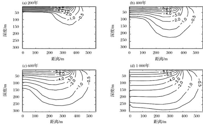
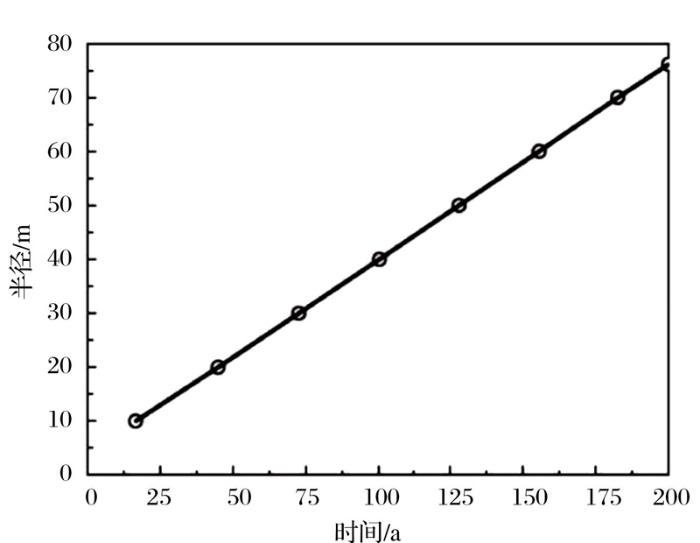