
由德方 , 王汝建, 肖文申
同济大学海洋地质国家重点实验室, 上海 200092
You Defang, Wang Rujian, Xiao Wenshen
中图分类号: P736.2
通讯作者:
收稿日期: 2018-09-7
修回日期: 2018-10-15
网络出版日期: 2018-11-20
版权声明: 2018 地球科学进展 编辑部
基金资助:
作者简介:
First author: You Defang(1992-), male, Qingdao City, Shandong Province, Master student. Research areas include polar paleoceanography and micropaleontology. E-mail: dfyou@tongji.edu.cn
作者简介:由德方(1992-),男,山东青岛人,硕士研究生,主要从事极地古海洋与微体古生物学研究.E-mail:dfyou@tongji.edu.cn
展开
摘要
对海洋生产力的研究有助于理解大洋碳库的变化,粉尘输入则是影响海洋生产力的重要因子。对德国SO202-INOPEX航次在北太平洋中部赫斯海隆(Hess Rise)钻取的SO202-37-2孔0~251 cm沉积物样品进行了XRF元素扫描,碳酸钙、生物硅、有机碳、浮游有孔虫Globigerina bulloides和Globorotalia inflata氧碳同位素的综合分析,以期探讨该区域的生源组分特征及粉尘输入的变化历史。该孔的地层年代框架基于其浮游有孔虫G. inflata-δ18O、G. bulloides-δ18O与H3571孔G. inflata-δ18O和深海氧同位素曲线LR04-δ18O的对比。结果显示,该孔XRF-Ti/Ca值所代表的陆源粉尘输入强度变化与生物硅含量显著相关,指示粉尘输入刺激了海洋生产力的提高,并呈现出间冰期增强、冰期减弱的特点。究其原因,可能是由于冰期时西风带南移远离物源区,导致粉尘输出减少,西风急流的经向移动控制了该区域海洋生产力的变化。尽管冰期时全球粉尘输出是增多的,但是西风急流的位置变化使得该区域的粉尘沉积记录与其他地区不完全相同。
关键词:
Abstract
The study of marine export production is helpful to trace the changes of oceanic and global carbon reservoirs. Dust input is an important factor inspiring marine export production. Measurements of carbonate, Opal, TOC and Corg/N were performed on Core SO202-37-2, which was retrieved from Hess Rise, central North Pacific during the German SO202-INOPEX Expedition, for reconstructing variations of the local export production and dust input. The core age model is constructed via morphologically correlating its foraminifer oxygen isotope record with those of Core H3571 and the LR04 stack. XRF-Ti/Ca can be used as a proxy for dust input and its distribution pattern is consistent with that of Opal content, possibly indicating that dust input may have affected the local export production, i.e. the local export production increased (decreased) with enhancing (declining) dust input during interglacial (glacial) periods. Fluctuations in dust input might be due to southward/northward migration of the Westerly Jet over the dust source regions during interglacial and glacial periods. Although global dust output increased during glacial periods, meridional migration of the Westerly Jet in this area made the distribution pattern of the dust deposition in the study area different from that of other areas.
Keywords:
粉尘是深海沉积物的主要成分之一,主要由风力搬运[1]。赫斯海隆(Hess Rise)位于北太平洋中部,其陆源沉积主要为东亚粉尘沉积[2,3]。实验证实粉尘可以提高海洋生产力的水平[4],进而降低海水中二氧化碳浓度,改变海水碱度及水体环境[5],研究生物泵的变化规律有助于研究大洋及全球碳库变化。粉尘通量与风力大小、距离物源区的远近密切相关,更主要的是与源区的气候条件相关[6],因此通过对海洋沉积记录中粉尘的研究可以追踪陆地物源区环境与气候变化。
虽然对北太平洋地区已经开展了很多古海洋及古气候的研究工作,但对于赫斯海隆所在的中部区域研究较少,前人主要针对海台形成与演化[7] 及一些地球物理参数进行研究[8],有待深入开展赫斯海隆晚第四纪以来的古海洋和古气候研究。对赫斯海隆南部的H3571站位(图1)[5,9~14]200 ka以来有机碳、生物硅等生源组分沉积通量与元素Al的沉积通量进行对比,研究人员认为粉尘的输入可以提高海洋生产力,且最大值出现在深海氧同位素(Marine Isotope Stages, MIS) 5期晚期至MIS 4期之间,MIS 2期相对较高,但是粉尘输入低于MIS 4期,而文献中没有给出合理解释[5]。
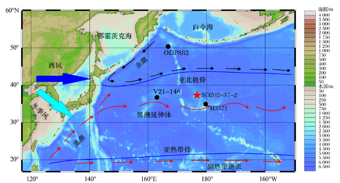
图1 北太平洋中部赫斯海隆SO202-37[
深蓝色实线表示极锋,红色带箭头虚线代表暖流,黑色带箭头虚线代表寒流;深蓝色箭头为西风环流方向,浅蓝色箭头为东亚冬季风风向
Fig.1 Map of climatic and oceanographic settings in the North Pacific showing locations of sites SO202-37[
Dark blue lines show respectively subarctic and subtropical fronts, red dashed lines with arrows show warm surface currents, black dashed lines with arrows show cold surface currents, dark blue arrow shows westerly wind and light blue arrow shows East Asian winter monsoon
北太平洋西部的V21-126站位记录了529 ka以来的粉尘变化,冰期时粉尘输入增多,认为这是东亚干旱程度增加的结果,粉尘整体呈增多的趋势[11]。对位于亚北极太平洋的ODP882站位170 ka以来的研究发现,MIS 6期、5d期、4期和2期粉尘通量较高[15],但是Serno对MIS 4期以及MIS 5e-5a期的年龄不是依据深海氧同位素曲线LR04-δ18O确定的期次界线进行划分的。本文将利用SO202-37-2孔的研究结果着重探讨晚第四纪以来赫斯海隆北部粉尘输入与生源组分之间的关系及其可能的影响机制。
赫斯海隆是北太平洋中部最突出的洋内海台之一,其碳酸盐补偿深度(Carbonate Compensation Depth, CCD)约4 500 m[7],深于太平洋平均3 500 m的CCD面。赫斯海隆距西侧的沙茨基海隆(Shatsky Rise)约1 500 km[5],整体呈西北向倾斜的倒T字型,其南面是门多西诺破裂带(Mendocino Rupture Zone),西面是皇帝海山链(Emperor Seamounts Chain),东北面以皇帝海槽(Emperor Trough)为界,分布范围为33°~42°N,173°E~173°W[8]。
黑潮是北赤道暖流的分支,具有高盐度、高流量、高温度的特点[16]。在日本列岛东南部海域,黑潮的一分支继续向北流动与亲潮交汇,形成亚北极锋,纬度在42°N左右[17],另一分支在西风带的影响下继续向东流,称为黑潮延伸体[12]。黑潮延伸体是影响研究区域的唯一洋流,呈大振幅弯曲流动,北侧与亚北极锋分区明显,分界区冬季海表温度梯度可达3 ℃/100 km[16]。黑潮延伸体会随着亚北极锋呈现季节性波动,在冬季可能会向南移动2°左右[7]。
SO202-37-2孔沉积物样品由德国R/V Sonne号科学考察船于2009年SO202-INOPEX航次采集,岩芯长24.35 m,本文仅研究该岩芯0~251 cm深度的样品,以3 cm为间隔取样,共取得84个样品。该段岩芯沉积物以褐色、黄色粉砂质黏土以及灰白色、浅灰色粉砂质黏土为主要特征,其中0~19 cm为黄色,19~60 cm为褐色,60~180 cm 为浅灰色—灰白色旋回,180~251 cm呈黄褐色[9]。该站位与西北太平洋对比站位信息见表1[5,9,11,15]。
表1 北太平洋中西部站位信息
Table 1 Information for the sites in central and western North Pacific
| 站位 | 纬度/N | 经度/E | 水深/m | 参考文献 |
|---|---|---|---|---|
| SO202-37 | 37°46.07' | 176°16.13' | 3 658 | [9](本文) |
| H3571 | 34°54.25' | 179°42.18' | 3 571 | [5] |
| V21-126 | 37°41' | 163°02' | 3 968 | [11] |
| ODP882 | 50°21' | 167°35' | 3 244 | [15] |
本文对SO202-37-2孔岩芯沉积物所做的分析包括:XRF元素含量扫描,浮游有孔虫Globigerina bulloides和Globorotalia inflata稳定氧碳同位素测试,生物硅含量、碳酸钙(CaCO3)含量和有机碳含量分析。其中XRF岩芯扫描是在德国阿尔弗雷德魏格纳研究所(Alfred Wegener Institute,AWI)完成,其他实验分析工作均在同济大学海洋地质国家重点实验室完成。
XRF元素含量扫描:使用Avaatech XRF岩芯扫描仪在1 cm分辨率下进行元素含量无损扫描,分别在15,30和50 kV电压下扫描3次,得到多种元素(Al-Ba)的相对含量,数据单位分别是counts/10 s,counts/15 s和counts/30 s[18]。
浮游有孔虫G. inflata和G. bulloides氧碳同位素分析:从大于250 μm的样品中挑出大小基本一致的G. inflata 壳体20枚左右;从154~250 μm的样品中挑出G. bulloides 壳体20枚左右。将处理好的有孔虫壳体用Finnigan MAT252型稳定同位素质谱仪测定氧碳同位素的比值,与国际Pee Dee Belemnite(PDB)尺度的衔接是通过国际标样NBS19进行的,δ18O和δ13C的测试误差分别是±0.07‰和±0.04‰[19]。
生物硅测试:取0.15 g干样依次加入过氧化氢和稀盐酸去除有机质和CaCO3;加入二次去离子水进行离心,滤出上层清液,温度50 ℃将样品烘干;利用碳酸钠溶液提取生物硅,与钼酸铵溶液反应生成硅钼黄,静置后加入抗坏血酸生成硅钼蓝,用分光光度计测得样品的吸光度,通过标准工作曲线计算得到样品中生物硅的含量[20],最终测量误差小于3%[21]。
CaCO3测试:取小于0.1 g的CaCO3标样置于二氧化碳真空气压泵中,使其与体积比为1∶ 3的稀盐酸反应,记录产生的气压值,测试标样至少3组,可得标准工作曲线。取0.1 g左右研磨好的干样放于容器中进行测量,通过产生的二氧化碳体积,经过计算得到样品中碳酸盐的百分含量[22]。
有机碳测试:取研磨后的样品0.1 g,加入1 mol/L的稀盐酸20 mL,超声震荡1 h,除去CaCO3,离心至pH=7,离心完成后将样品烘干,并再次研磨。称取约10 mg样品,在Thermo Quest Italia.S.P.A.有机元素分析仪(EA1110型)上进行测试,分析误差小于0.3%[23]。结合CaCO3质量和含量等数据计算出全样中总有机碳(Total Organic Carbon,TOC)的含量和Corg/N值。
浮游有孔虫G. inflata和G. bulloides主要分布在中纬度海区,分别为次表层种和表层种,是所研究样品中的优势种,且连续性较好[12],其氧同位素曲线如图2所示。G. bulloides-δ18O 的变化范围为0.73‰~2.41‰,平均值为2.06‰,最大值出现在深度235 cm处,最小值出现在187 cm深度,251~180 cm氧同位素逐渐变轻,180~115 cm变重,115~95 cm小幅偏轻,95~30 cm呈变重趋势,在30 cm处变重明显。G. inflata-δ18O的变化范围为0.95‰~2.60‰,平均值为1.72‰,最大值为2.60‰,出现在28 cm深度,最小值为0.96‰,出现在223 cm深度,251~223 cm氧同位素值变轻,223~28 cm呈变重趋势,28 cm深度达到最大值。
图2 北太平洋中部赫斯海隆SO202-37-2孔G. bulloides-δ18O、G. inflata-δ18O和H3571孔G. inflata-δ18O[
Fig.2 Chronostratigraphic framework of Core SO202-37-2 from the Hess Rise, central North Pacific, assigned with marine isotope stages (MIS), stratigraphic correlations between LR04 stack[
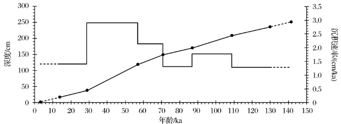
通过G. inflata-δ18O,G. bulloides-δ18O和H3571孔的G. inflata-δ18O与标准深海氧同位素曲线LR04-δ18O对比,确定其年龄控制点(图2) [5,24],左侧坐标轴表示SO202-37-2孔及H3571孔岩芯长度,右侧坐标轴为LR04-δ18O确定的标准年龄,H3571孔G. inflata-δ18O的数据取至深度251 cm。SO202-37-2孔和H3571孔MIS 2期氧同位素均出现明显的重值,MIS 3期波动幅度不大,MIS 4期出现小幅的变重,其中H3571孔氧同位素值变重更为明显,MIS 5期中3个峰值明显,依次确定了MIS 4/5a、5b(谷底)、5d(谷底)、5e/6期的界线。确定的7个年龄控制点如表2所示,通过内插法将SO202-37-2孔深度转化成年龄,得到该岩芯底部年龄达141.7 ka,为MIS 6期晚期。年龄模式和沉积速率图如图3所示,MIS 3期沉积速率最高,为2.9 cm/ka,平均沉积速率为1.8 cm/ka。
表2 北太平洋中部赫斯海隆SO202-37-2钻孔年龄控制点
Table 2 Age control points of Core SO202-37-2 from the Hess Rise, central North Pacific
| 深度 /cm | 期次 界线 | 年龄 /ka | 深度 /cm | 期次 界线 | 年龄 /ka |
|---|---|---|---|---|---|
| 16.5 | 1/2 | 14 | 169.5 | 5b(谷底) | 87 |
| 37.5 | 2/3 | 29 | 208.5 | 5d(谷底) | 109 |
| 118.5 | 3/4 | 57 | 235.5 | 5/6 | 130 |
| 148.5 | 4/5 | 71 |
图3 北太平洋中部赫斯海隆SO202-37-2孔年龄模式及沉积速率
黑色点为深度—年龄控制点,虚线为外推趋势线
Fig.3 Age model and sedimentation rate of Core SO202-37-2 from the Hess Rise, central North Pacific
Black dots are depth-age control points, and dashed lines are extrapolated trendlines
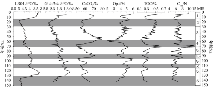
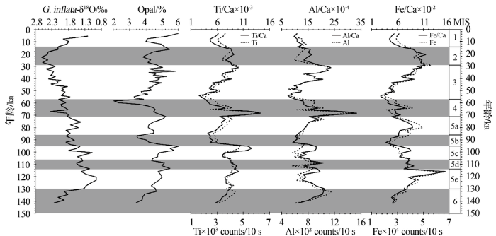
CaCO3含量变化范围为50%~79%,平均值为62.2%(图4)。MIS 6~5c期CaCO3含量呈下降趋势,其中MIS 5c和5e期内分别出现2个高值;MIS 5c晚期至MIS 5a晚期CaCO3含量先快速上升后逐渐下降,高值71.89%出现在5b期内;MIS 5a晚期至MIS 2晚期CaCO3含量同样先上升后下降,MIS 3早期(约55 ka) 达最高值79%;MIS 2晚期之后快速上升。CaCO3含量整体呈现出间冰期减小,冰期增大的特点,要注意的是,这里所说的减小不是低值的意思,而是一种变化趋势,因为CaCO3含量极大值都出现在冰期/间冰期界线附近。
图4 北太平洋中部赫斯海隆SO202-37-2孔生源组分含量变化图
Fig.4 Variation in percentage of biogenic components of Core SO202-37-2 from the Hess Rise, central North Pacific
生物硅(Opal)含量变化范围为2%~6%,平均值为4.7%(图4)。MIS 6期至MIS 5c晚期Opal含量呈上升趋势,高值出现在MIS 5c/MIS 5b界线,Opal含量达6%;MIS 5b~5a期Opal含量快速下降并逐渐上升,低值出现在5b晚期;MIS 4~3期Opal含量同样快速下降并逐渐上升,MIS 4晚期(约58.4 ka)达到最小值2%;MIS 2期先下降后上升,在22.5 ka时达到低值。CaCO3和Opal含量变化为明显反相关关系。
TOC含量整体较低,变化范围为0.17%~0.64%,平均值仅为0.34%。MIS 6期至MIS 5a早期,TOC含量在0.3%上下波动;MIS 5a期明显上升,MIS 5a晚期(68~70 ka)达最大值0.64%,且高于表层TOC含量;进入MIS 4期,TOC含量快速下降;MIS 3期至MIS 2晚期,TOC含量缓慢上升,MIS 2晚期快速下降。TOC含量的变化趋势与Opal含量变化一致,呈现出间冰期增大,冰期减小的特点。Corg/N的平均值为6.7,峰值几乎与TOC含量峰值一致,MIS 5a晚期至MIS 4早期Corg/N值较高,其他时期基本在平均值上下波动。
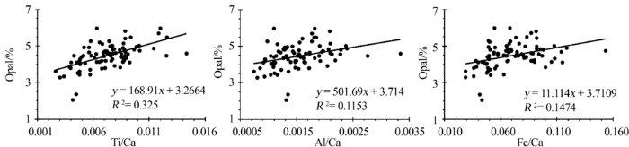
对Ti,Al和Fe含量分别与Ca含量相除,以两元素比值作为陆源粉尘输入强度的指标,比值越大,说明粉尘输入越多。Ti/Ca,Al/Ca和Fe/Ca值基本呈现出间冰期增加,冰期减小的特点(图5)。虚线分别为元素Ti,Al和Fe含量变化,与Ti/Ca,Al/Ca和Fe/Ca值变化基本一致,其中Ti/Ca值与Ti含量相关性最高。对3个比值与Opal含量做相关性分析,结果如图6所示。Ti/Ca值与Opal含量相关性最高,相关系数为0.33;Fe/Ca值与Opal含量的相关系数为0.15;Al/Ca值与Opal含量相关性最低,相关系数为0.12。
图5 北太平洋中部赫斯海隆SO202-37-2孔Ti/Ca, Al/Ca, Fe/Ca值及Ti, Al, Fe含量与Opal含量对比
Fig.5 Variations in Ti/Ca, Al/Ca, Fe/Ca ratios and Ti, Al, Fe content in comparison with percentage of Opal in Core SO202-37-2 from Hess Rise, central North Pacific
图6 北太平洋中部赫斯海隆SO202-37-2孔Ti/Ca, Al/Ca和Fe/Ca值与Opal含量相关性
Fig.6 Linear relationship of Ti/Ca, Al/Ca, Fe/Ca ratios with percentage of Opal in Core SO202-37-2 from Hess Rise, central North Pacific
研究站位距陆地较远,河流搬运不是主要的搬运介质[25],粉尘是研究区域主要的陆源物质组成[5,26]。元素Ti和Al主要来自于陆源硅酸盐矿物,元素Fe则有粉尘和热液2种来源[27],赫斯海隆的沉积物为钙质软泥,Ca来源于钙质生物壳体[12]。使用元素比值可以减少生源对陆源元素含量的影响,同时体现出陆源组分与生源碳酸盐相对含量的变化。通过Ti/Ca、Al/Ca值与Opal含量的相关性分析(图6),Ti/Ca值与Opal含量所代表的硅质生产力显著相关(R2<0.09, 微弱相关; 0.09~0.25, 低度相关; 0.25~0.64, 显著相关; 0.64~1, 高度相关 [28])。
另外,在赤道太平洋地区的研究发现,元素Al含量可能与生源有关,所以Ti作为陆源指标更加准确[29,30]。有的学者通过ICP光谱仪测量等得到元素Ti的含量,作为陆源输入指标[31,32],而XRF-Ti/Ca值作为粉尘指标同样被广泛应用[33,34]。本文使用XRF-Ti/Ca值代表粉尘输入强度的变化。
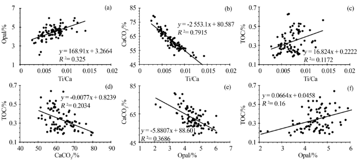
深海沉积物中的Opal是指由硅藻、放射虫、海绵骨针等硅质生物骨骼组成的无定型二氧化硅,其含量可以反映海洋硅质生物初级生产力的水平[35];深海沉积物中的TOC含量指示从海表输出,并沉积到海底的总有机碳丰度,是反映表层生产力变化的最直接指标[36]。结合图4和图5可以看出,Ti/Ca值与Opal以及TOC含量近似呈正相关关系,冰期减小,而间冰期增大;TOC含量与Opal含量变化基本一致,说明TOC可能主要是由硅藻产生并沉积的。通过相关性分析(图7)发现,Ti/Ca值与Opal含量为显著相关,Ti/Ca 值与TOC含量为低度相关(图7a,c),因此,可以认为以Ti/Ca 值代表的陆源粉尘输入增加,促进了Opal含量增加。TOC与粉尘输入的相关系数并不高,可能是与其他陆源有机质的输入或者TOC的降解有关。而Opal含量增加代表表层硅藻等硅质生物的繁盛,即初级生产力的提高,可能是由于粉尘中含有Fe这一刺激因子,在营养物质充足的条件下,促进了浮游植物的繁盛[37]。
图7 北太平洋中部赫斯海隆SO202-37-2孔Ti/Ca值、Opal、CaCO3、TOC含量之间相关性
Fig.7 Linear relationship of Ti/Ca ratio, percentages of Opal, CaCO3 and TOC in Core SO202-37-2 from Hess Rise, central North Pacific
深海沉积物中的CaCO3包含有孔虫和颗石藻等钙质生物骨骼2个部分。颗石藻等钙质生物会与硅藻竞争磷酸盐和硝酸盐等营养盐,同时也受铁和硅供应的影响[38,39],如果CaCO3以颗石藻等为主,则会与Opal含量呈反相关关系,如果CaCO3以有孔虫为主,则会与Opal含量呈正相关关系[40],因为粉尘的输入会促进硅质生物繁盛及有机质的增加,进一步促进有孔虫的繁盛。因CaCO3与Opal含量为显著负相关(图7e),说明颗石藻等为CaCO3的主要组成。CaCO3含量与Ti/Ca值高度负相关(图7b),说明粉尘的输入使硅藻数量上升,颗石藻的生存受到抑制,且CaCO3对粉尘输入的响应更加敏感,因此TOC含量与CaCO3含量的相关性也要高于TOC含量与Opal含量的相关性。
Corg/N值可以作为判断海洋沉积物来源的有效指标,海源有机质中浮游植物的Corg/N值为6~7[41,42],沉积物中海源有机质的Corg/N值为8~9[43],而陆源有机质的Corg/N值为20~200[44]。由Corg/N值可以看出(图4),除MIS 5a/MIS 4期界线,Corg/N值达12,可能反映有机质是混合来源之外,其他时期Corg/N值在6~8变化,说明海源沉积是有机质的主要来源;而MIS 5a/MIS 4期界线出现较高的Corg/N值,可能与粉尘带入较多的陆源有机质有关。
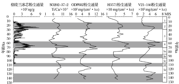
北太平洋作为主要的粉尘沉积区,不同位置粉尘沉积之间存在差异。SO202-37-2孔与3个对比站位钻孔位置如图1[5,9~14]所示,具体站位信息见表1[5,9,11,15]。MIS 6期以来的4个站位粉尘输入变化及格陵兰冰芯粉尘通量如图8[5,11,15,45]所示。格陵兰冰芯以不可溶解组分浓度作为粉尘浓度[45],SO202-37-2孔以XRF-Ti/Ca值表示粉尘输入,ODP882孔以230Th标准化的4He通量代表粉尘通量[15],H3571孔以化学提取元素Al的含量代表粉尘沉积通量[5],V21-146孔的粉尘通量为原样除去CaCO3、生物硅以及人为估计的涂片中火山灰含量后计算所得[11],而且该站位处于东亚东季风的路径上,会沉积相对更粗的颗粒。
图8 格陵兰冰芯粉尘通量[
Fig.8 Comparison of dust input in Greenland ice core[
格陵兰冰芯记录了MIS 5d期以来的粉尘通量变化,该通量反映的是东亚沙漠的粉尘输出变化,东亚季风以及西风急流是主要传输动力。MIS 4早期粉尘通量明显增加,MIS 4中晚期粉尘通量明显减少,变化趋势与SO202-37-2孔Ti/Ca值变化一致,MIS 3期冰芯中粉尘通量依然较高,在MIS 2早期(约24~26 ka)粉尘通量出现高值,其后粉尘通量呈减小趋势,MIS 4至MIS 2期粉尘通量的增加可能与东亚风暴的增多和东亚冬季风系统的增强有关[46]。
在北太平洋中西部4个站位中,除V21-146孔外,其他3个站位钻孔的粉尘通量基本呈现出间冰期增多,冰期减少的趋势,三者间的峰值不能完全对应,可能是由于建立的年龄模式差异导致[15]。要强调的是,减小不等于出现低值,前者强调的是一段时间内的变化趋势,粉尘沉积的峰值出现在间冰期晚期或冰期早期,所以冰期粉尘输入整体上是减少的变化过程,但并不等同于间冰期粉尘沉积多于冰期。另外,位于北太平洋中部的SO202-37和H3571站位的粉尘传输机制也不同于ODP882和V21-146站位,ODP882和V21-146站位可能会受东亚冬季风的影响。冰期或者冰段时由于气候干旱,传输动力增强,通常认为粉尘沉积应是增多的,但是这不能解释北太平洋中部地区冰期时粉尘减少,高值出现在间冰期或冰进期的现象,因此对于该区域除物源区的气候变化外,西风急流可能是粉尘输入变化主要的控制因素。另外,MIS 2期时冰芯中的粉尘通量高值高于MIS 4期,而在北太平洋站位MIS 4期时的粉尘输入明显高于MIS 2期,可能与MIS 2期时西风急流较MIS 4期更加南移,更加远离物源区有关。
另外,ODP882孔的粉尘通量远高于H3571孔,不能排除不同计算方法之间结果的差异,根据最新的研究结果,赫斯海隆所在的北太平洋中部区域粉尘通量高于亚北极太平洋[47],所以H3571孔的粉尘通量大小存在疑问,有待进一步核查。
西风环流是粉尘搬运的主要传输动力[5],在其作用下,粉尘可以在高空进行几千公里的搬运[48],粗颗粒的成分则主要受季风环流的控制[49]。东亚亚热带西风急流(East Asian Subtropical Westerly Jet, EASWJ)是指西风带中风速最强的区域,长距离粉尘搬运主要受急流区的控制[50]。据现代观测显示,西风带会发生季节性的迁移,盛夏时急流区位于38°~40°N,隆冬时则南移至30°~32°N[50]。有研究表明,东亚冬季风搬运的主要物源区为蒙古戈壁和黄土高原,而西风环流运输的粉尘来自于塔里木盆地和黄土高原[3,51],我国黄土高原大致分布在32°~41°N,塔里木盆地约在37°~42°N。因此,盛夏时西风急流会对粉尘输出产生极大影响。
西风带的南移会使得急流区逐渐远离物源区,导致粉尘输出逐渐减少,降低陆源Fe的输入,从而降低海洋生产力。如果把冰期时的平均情况与冬季类比,间冰期的平均情况与夏季类比(图9)[14,46]。
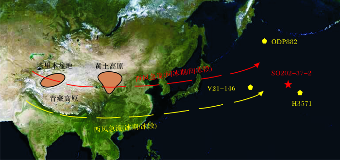
图9 东亚及北太平洋冬夏两季西风急流示意图[
遥感图像来源于http:∥search-image.tianditu.com
Fig.9 The location of Westerly Jet in East Asian and the North Pacific during winter and summer[
Remote sensing image comes from http:∥search-image.tianditu.com
冰期时,北半球高纬冰盖的形成和扩张会导致西比利亚高压的增强,导致西风急流南移[52,53],甚至可移至青藏高原南侧[14],远离黄土沉积区,导致粉尘输出的减少,若冰期更强,则急流可能愈加偏离物源区,因此,在末次盛冰期,粉尘输入甚至低于MIS 4早期及MIS 5c晚期(图5)。但值得注意的是,在MIS 2晚期,粉尘沉积增多可能与华南地区粉尘输出增加有关。
通过北太平洋中部赫斯海隆SO202-37-2孔0~251 cm深度浮游有孔虫G. inflata和G. bulloides氧碳同位素、CaCO3、Opal、TOC、XRF岩芯扫描等分析,研究了MIS 6期以来SO202-37-2孔生源组分与粉尘输入的变化特征,并与西北太平洋其他站位及格陵兰冰芯的粉尘通量进行对比,得出了以下结论:
(1) 通过该孔浮游有孔虫G. inflata,G. bulloides-δ18O与H3571孔G. inflata-δ18O和深海氧同位素曲线LR04-δ18O进行对比,建立了该站位的年代地层框架,底部年龄141.7 ka,为MIS 6期以来的沉积记录,平均沉积速率为1.8 cm/ka。
(2) XRF-Ti/Ca值可以作为粉尘输入强度的替代性指标,MIS 5e晚期、MIS 5c晚期、MIS 4早期以及MIS 3晚期Ti/Ca值出现高值,说明粉尘输入的明显增多。粉尘输入整体呈现出冰期减小,间冰期增大的特点。
(3) 生物硅含量与Ti/Ca值显著相关,在MIS 5e/5d期界线、MIS 5c/5b期界线、MIS 5a/4期界线以及MIS 3晚期生物硅含量出现高值,整体呈现冰期减小,间冰期增大的特点。陆源粉尘输入量增加,促进了表层硅藻等硅质生物的繁盛,即初级生产力的提高,可能是由于粉尘中含有Fe这一刺激因子,在营养物质充足的条件下,促进了浮游植物的繁盛。
(4) 西风环流是粉尘传输的主要机制,北太平洋中部地区明显受西风急流的控制。冰期时西风急流较间冰期整体偏南,远离黄土高原、塔里木盆地等物源区,使得粉尘输出减少,而间冰期西风急流经过物源区,使得该区粉尘输出增多,从而导致海洋生产力提高。尽管冰期时全球粉尘输出是增多的,但是在北太平洋中部地区由于西风急流位置的变化,使得粉尘沉积记录与其他地区不完全相同。
致 谢:德国SO202-INOPEX航次全体科考人员,特别是地质组成员对沉积物采集付出努力,德国AWI研究所提供了研究所用样品及XRF元素扫描数据。在此对他们表示真诚的感谢!
The authors have declared that no competing interests exist.
| [1] |
Eolian contributions to marine sediments [J]. |
| [2] |
Provenance of dust in the Pacific Ocean [J].
Eolian dust preserved in deep-sea sediment cores provides a valuable indicator of past atmospheric circulation and continental paleoclimate. In order to identify the provenance of eolian dust, Nd and Sr isotopic compositions and Rb, Sr and rare earth element (REE) concentrations have been determined for the silicate fractions of deep-sea sediments from the north and central Pacific Ocean. Different regions of the Pacific Ocean are characterized by distinct air-borne inputs, producing a large range in [epsilon]Nd (-10 to +1), 87Sr/86Sr (0.705-0.721), La/Yb (5-15), EuN/EuN* (0.6-1.0) and Sr/Nd (4-33). The average Nd isotopic composition of Pacific deep-sea sediments ([epsilon]Nd = -6), is more radiogenic than the average from the Atlantic ([epsilon]Nd = -8). In contrast, the average 147Sm/144Nd ratio for Pacific sediments (0.114) is identical to that of Atlantic sediments and to that of global average riverine suspended material. The values of [epsilon]Nd and 147Sm/144Nd are positively correlated for the Pacific samples but negatively correlated for Atlantic samples, reflecting a fundamental difference between the dominant components in the end members with radiogenic Nd (island-arc components in the Pacific and LREE-enriched intraplate ocean island components in the Atlantic). Samples from the north central Pacific have distinctive unradiogenic [epsilon]Nd values of -10, 87Sr/86Sr > 0.715, high La/Yb (> 12), and low EuN/EuN* (0.6) and Sr/Nd (3-6). These data are virtually identical to the values for loess from Asia and endorse the use of these sediments as indicators of Asian paleoclimate and paleowind directions. Island-arc contributions appear to dominate in the northwest Pacific, resulting in higher [epsilon]Nd (-1 to +1) and lower 87Sr/86Sr ([approximate] 0.705) and La/Yb ([approximate] 5). Sediments from the eastern Pacific tend to have intermediate Sr and Nd isotopic compositions but regionally variable Sr/Nd and REE patterns; they appear to be derived from the west margin of the North and South American continents, rather than from Asia. Our results confirm that dust provenance can be constrained by isotopic and geochemical analyses, which will facilitate reconstructions of past atmospheric circulation and continental paleoclimate.
|
| [3] |
Research progress of dust emission in Asia [J].亚洲粉尘释放的研究进展 [J].
我国北方沙漠、黄土高原、青藏 高原是亚州粉尘释放的关键区域。进一步的元素示踪研究表明,我国西部和北部沙漠是亚洲粉尘和黄土高原黄土的主要源区;太平洋地区和格陵兰地区粉尘的源区为 东亚地区。近地面风和高空西风带是亚洲粉尘传输的主要途径。北太平洋粉尘沉积和格陵兰冰芯粉尘记录对比表明,亚洲粉尘的产生、搬运和沉积在这些记录中既表 现出一致性,也存在某些差异,显示了搬运过程、沉积过程以及区域性因素对粉尘记录的影响。
|
| [4] |
Seasonal patterns of vertical particle flux in equatorial and coastal upwelling areas of the eastern Atlantic [J].
Eight time-series sediment traps were deployed on moored arrays off Mauritania (Cap Blanc), in the northern and southern Guinea Basin, and off Namibia (Walvis Ridge). The highest total fluxes (66.8 and 59.1 g my), as well as carbonate (28.7 and 32.9 g my) and biogenic opal fluxes (5.4 and 8.2 g my) were recorded at the two coastal sites, off Mauritania and off Namibia, respectively. Intermediate rates were recorded north and low rates south of the equator. Surprisingly, carbonate-producing organisms dominated total fluxes at all sites, whereas biogenic opal was only a minor contributor. The most distinct flux maxima were in July-August both at the Cap Blanc and the northern Guinea Basin site (2N). Carbonate fluxes also peaked during that period. In contrast, highest opal fluxes were measured there in late winter/early spring. At the Cap Blanc site, high lithogenic fluxes correlate well with fluxes of biogenic components. At both equatorial sites, prominent flux maxima were observed in boreal spring, attributed to the southermost penetration of the ITCZ. These fluxes were characterized by a relatively high lithogenic contribution. South of the equator (2S), sedimentation decreased rapidly to almost zero after May when the ITCZ started to migrate northwards. Seasonality was most expressed at the Walvis Ridge site, where a distinct bi-modal flux pattern occurred (June-July and October-November). In austral spring, elevated fluxes were determined for a relatively long period when wind-driven upwelling is strongest and the Namibia upwelling cell shows the greatest extension to the west approaching the trap position. Contribution of lithogenic material to total fluxes was very low at this site.
|
| [5] |
Fluctuations of eolian flux and ocean productivity in the mid-latitude north Pacific during the last 200 kyr [J].DOI URL [本文引用: 18] 摘要
In order to understand fluctuations in terrestrial and marine environments, a sedimentary core H3571 was investigated from the Hess Rise located in the mid-latitude North Pacific under the north westerly wind system. The δ 18 O, grain size and grain shape of type 1 quartz suggest that this quartz is of aerosol origin. Good correlation between Al and aerosol quartz in content and mass accumulation rate (MAR) indicates that the alumino silicate minerals in the sediments are mainly transported by wind. MAR of mineral aerosol (MAR Aerosol) varies from 156 to 732 mg cm 612 kyr 611 during the last 200 kyr. The MAR Aerosol maxima occur in oxygen isotope stage (OIS) 4 to latest OIS 5, middle OIS 6, moderate maxima occur in early OIS 1–2, late OIS 3 and middle OIS 3. These maxima are ascribed to reduced precipitation during the summer monsoon and to strengthened wind speed during the winter monsoon. The mean organic carbon/total nitrogen atomic ratio is 7.2, suggesting that the organic matter in the core H3571 is also mainly of marine origin. The MAR of organic carbon (MAR Organic) exhibits two prominent maxima in OIS 2 and 4 and relatively high values in middle and late OIS 6. Enhanced primary productivity is most likely to be responsible for the high burial rate of organic carbon in the sediments. Carbonate and phosphorus inputs with aerosol into sea surface have played a minor role through dissolution in diminishing PCO 2 in surface water during glacial times. On the other hand, the aerosol silica supply to the ocean may have some potential to affect the burial of biogenic silica into sediments. The effect of mineral aerosol on the ocean carbon cycle would be greater in the coastal and hemipelagic regions of the Western Pacific and Equatorial Atlantic, as compared with that in the Hess Rise regime.
|
| [6] |
Geologic approach to the long-term history of atmospheric circulation [J].
Eolian dust preserved in deep-sea pelagic sediments can be used as a proxy indicator of paleoclimate. Analyses of the particle size, composition, and mass accumulation rate of dust grains provide independent evidence of the intensity of atmospheric circulation and the availability of material in the eolian source region. These data provide information on atmospheric circulation and on the climate of the source area at time scales ranging from 10$^{3}$ to 10$^{8}$ years and have the potential to test computer-generated global circulation models.
|
| [7] |
Marine geology of the Hess Rise: 1. Bathymetry, surface sediment distribution, and environment of deposition [J].
New charts of bathymetry, acoustic character, and sediment distribution describe the Hess Rise, a large oceanic plateau in the central north Pacific. Discrete physiographic provinces on the Hess Rise are the High Plateau, shallower than 3900 m, trending N30 W; the Northeastern Flank, a smooth, gentle slope gradually increasing in depth to the northeast; the Woollard Abyssal Plain, extending farther to the northeast; the Volcanic Province with its high peaks and ridges along the southern margin of the Hess Rise; the Mendocino Fracture Zone to the south, expressed by broad, planar seafloor regions bordered by ridges and scarps; the Western Steps, formed by structural benches on the western side of the Rise; and the Emperor Deep, between the rise and the Emperor Seamounts. Five types of acoustic units have been mapped and interpreted: a transparent layer, predominantly of biosiliceous pelagic clay; a stratified layer, predominantly of nannofossil ooze; a diffuse layer of debris flows that seem to have originated mostly in the Volcanic Province; an opaque horizon commonly formed of volcaniclastic sediments that are usually found on the seafloor of the Mendocino Fracture Zone; and a hyperbolic horizon, indicating outcrops of igneous rock. The pronounced effect of bottom currents on the present-day environment of deposition in the Hess Rise is evidenced by the presence of the opaque horizon, which is interpreted as an erosion surface, and by current moating, abrupt thinning of surface layers and truncation of subbottom reflectors. The widespread erosion on the seafloor of the Mendocino Fracture Zone is attributed to the flow of Antarctic bottom water.
|
| [8] |
Geologic evolution of Hess Rise, central North Pacific Ocean [J].
Abstract Cores from DSDP sites 310, 464, 465, and 466 and seismic-reflection profiles provide data that are used to interpret the geological evolution and paleoenvironments of Hess Rise, a prominent oceanic plateau in the central North Pacific Ocean. Hess Rise apparently formed in the S Hemisphere along the W flank of the Pacific-Farallon Ridge 110-100Ma B.P. Core stratigraphies and lithologies show the response of sedimentation to subsidence and N movement of Hess Rise on the Pacific plate. Oceanic islands, which crowned Hess Rise during its early evolution, were eroded and subsequently subsided below sea level. Major structural trends are identified. Many faults were active during sedimentation. -from Authors
|
| [9] |
The expedition of the research vessel "Sonne" to the subpolar North Pacific and the Bering Sea in 2009 (SO202-INOPEX) [J]. |
| [10] |
Glacial/interglacial changes in subarctic North Pacific stratification [J].
Since the first evidence of low algal productivity during ice ages in the Antarctic Zone of the Southern Ocean was discovered, there has been debate as to whether it was associated with increased polar ocean stratification or with sea-ice cover, shortening the productive season. The sediment concentration of biogenic barium at Ocean Drilling Program site 882 indicates low algal productivity during ice ages in the Subarctic North Pacific as well. Site 882 is located southeast of the summer sea-ice extent even during glacial maxima, ruling out sea-ice-driven light limitation and supporting stratification as the explanation, with implications for the glacial cycles of atmospheric carbon dioxide concentration.
|
| [11] |
Late Pleistocene continental climate and oceanic variability recorded in Northwest Pacific sediments [J].
Core V21-146 provides a continuous record of northwest Pacific pelagic sedimentation spanning the past 530,000 years. Downcore variations of 020718O from benthic foraminiferal calcite were correlated to the SPECMAP record to provide an age model for late Pleistocene paleoclimatic and paleoceanographic variation. Fluxes of CaCO3 and eolian material have been determined by combining information about linear sedimentation rates, bulk densities and component percentages. The mass accumulation rate (MAR) of CaCO3 varies from 58 to 1435 mg(cm0005 kyr)0908081 and exhibits the Pacific Ocean pattern of higher accumulation associated with glacial periods for the younger portion of the record. However, the pattern of CaCO3 accumulation appears to shift during the mid-Brunhes so that prior to 350,000 years ago it exhibits an opposite pattern of greater accumulation during interglacial periods. The flux of eolian dust is a proxy measure of the source area aridity and correlates well to the loess-soil stratigraphy in China. Dust fluxes range from 43 to 718 mg(cm0005 kyr)0908081 and are greater by a factor of about 4 during glacial times. Cross-spectral analysis of the eolian flux and oxygen isotope records shows an inphase and coherent relationship at each of the major orbital periodicities of 100, 41, and 19 kyr. Eolian grain sizes, generally used as a proxy record of wind intensity, range from 8.40504 (2.9 0008m) to 6.20504 (13.6 0008m). A change in grain size variability occurs near about 300 ka such that the older portion is characterized by lower-frequency and higher-amplitude fluctuations than the younger portion. Power spectra for the eolian grain size record show dominant peaks at 100 and 50 kyr and a broad 2509000935 kyr peak but coherency to the oxygen isotope curve at only the 100 and 33 kyr periodicities. The phase relationship for eccentricity between the eolian grain size and 020718O records suggests that at the 100 kyr frequency the smallest grain sizes are associated with glacial conditions.
|
| [12] |
A 370-ka paleoceanographic record from the Hess Rise, central North Pacific Ocean, and an indistinct 'Kuroshio Extension' [J].
A 5 m long core (NP36) collected from the Hess Rise in the central North Pacific Ocean (34°11.7′N, 179°15.4′E, water depth 2664 m) was analyzed for benthic and planktonic foraminifera. This core yields a continuous record for the last ca. 37064000 years according to the oxygen isotope stratigraphy. Cross-spectral analysis of down-core variations in planktonic δ18O values correlates well with the SPECMAP reference scale allowing recognition of marine isotope stages (MIS) down to MIS 10 and the δ18O variations coincide well with the changes in sea surface temperature derived using the modern analogue technique. Time-series analyses of mass accumulation rates (MAR) of planktonic and benthic foraminifera were also performed along with analysis of variations in faunal composition. MAR of planktonic foraminifera display maxima during glacial periods which, together with coincident changes in lightness (L*) of sediment measured with the spectrophotometer, strongly suggests increasing flux of eolian dust to the Hess Rise due to strengthened westerly winds. However, MAR of benthic foraminifera including Epistominella exigua, a common typical phytodetritus feeder, also display highest increases during some interglacial periods (i.e. MIS 5 and 7). The benthic MAR maxima are thought to reflect variations in consumption patterns between benthic and planktonic species. A proposed hypothesis that vigorous grazing of phytoplanktons occurred during glacial periods reducing the flux of phytodetritus to the sea floor in turn impacting and limiting production of benthic foraminifera with the opposite effect prevailing during interglacial periods. Down-core variations in right-coiling Neogloboquadrina pachyderma abundance and the composition of planktonic foraminiferal faunas indicate the Subarctic Front did not shift southward over the study site during the past 37064000 years. Alternatively, variations in faunal composition indicate that Subtropical Water prevailed in the study area throughout this period. No clear faunal evidence of the presence of the ‘Kuroshio Extension’ was found in core NP36 reflecting the loss of heat and tropical faunal elements from this water mass as it flowed eastward during late Quaternary climatic maxima and minima.
|
| [13] |
A comparison of characteristics between the subtropical countercurrent, the north equatorial current and the north equatorial countercurrent in the Northwestern Pacific Ocean [J].西北太平洋副热带逆流、北赤道流、北赤道逆流几个特征的比较 [J].
根据 1 37°E断面 1 967~ 1 995年冬、夏季的温、盐资料 ,计算和分析该断面的地转流 ;分析 1 44°E断面上投放卫星跟踪漂流浮标的漂移轨迹 ;结合 CSK图集中的海面重力势分布 ,对副热带逆流、北赤道流和北赤道逆流几个特征的相同点和不同点进行比较 ,得出若干有益的结论 :( 1 )副热带逆流、北赤道流、北赤道逆流 ,并不是单纯的单支海流 ,而是存在着两支或多支现象 ;( 2 )流速结构的带状分布 ,东、西向流相互交错间隔出现 ,流层较浅 ,均为表层流或近表层流 ;( 3)多年平均而言 ,3支海流的流速以北赤道逆流最强 ,北赤道流次之 ,副热带逆流最弱 ;流量则不同 ,北赤道流
|
| [14] |
Orbital- and millenial-scale variations in Asian dust transport path to the Japan Sea [J].
Orbital- and millennial-scale variations in the Asian monsoon and its probable association with the Dansgaard–Oeschger (D–O) Cycles have been demonstrated by previous studies. However, the origin and nature of such variations are poorly understood. The Japan Sea is located down wind of the arid areas of the Eurasian continent, and thus receives significant amounts of aeolian dust. Consequently, the hemipelagic sediments of the Japan Sea are expected to record a continuous aeolian dust accumulation, which may provide information about the past variations in Asian monsoon. Grain size, flux, and provenance of aeolian dust in the sediments were examined using two sediment cores obtained from the northern and southern parts of the Japan Sea in order to understand the spatial variability of Asian monsoon. Since the silt fraction of the detrital materials in hemipelagic sediments of the Japan Sea is composed predominantly of aeolian dust, the grain size, flux, and provenance of the silt fraction were examined. The Taklimakan Desert–Loess Plateau and Siberia–Northeast China areas were identified as possible source areas of aeolian dust in the sediments of the Japan Sea based on the Electron Spin Resonance (ESR) signal intensity and crystallinity of quartz. Moreover, the relative contribution of aeolian dust from each source area was estimated based on the ESR signal intensity and crystallinity of quartz. Aeolian dust fluxes from the two source areas at the southern site were then estimated. Grain size and flux of eolian dust at the northern site, and fluxes of aeolian dust from two source areas at the southern site show orbital-scale variations in harmony with the insolation change at 30° N in June. These results indicate orbital-scale changes in the extent of the arid area and/or frequency of dust storms in the Taklimakan Desert–Loess Plateau and Siberia–Northeast China areas, and suggest that southward (northward) shifts of the westerly jet axis occurred together with either intensified (weakened) winter monsoon, decreased (increased) winter precipitation in the Siberia–Northeast China area, or southeastward (northwestward) shifts of summer monsoon limit during periods of smaller (larger) insolation at 30° N in June. In addition to these orbital-scale variations, millennial-scale variations possibly associated with the D–O Cycles are observed in the grain size record of aeolian dust at the two sites. Based on analogy with orbital-scale variations, these millennial-scale variations are considered to reflect millennial-scale changes in the position of the westerly jet axis together with the changes either in winter monsoon intensity, winter precipitation, or position of summer monsoon limit. Our results suggest N–S oscillations in the westerly jet and summer monsoon limit, and changes in the intensity of the winter monsoon on orbital and millennial timescales.
|
| [15] |
Change in dust seasonality as the primary driver for orbital-scale dust storm variability in East Asia [J].
Glacial periods are recognized to be dustier than interglacials, but the conditions leading to greater dust mobilization are poorly defined. Here we present a new high-resolution dust record based on 230Th-normalized 4He flux from Ocean Drilling Program site 882 in the Subarctic North Pacific covering the last 170,000 years. By analogy with modern relationships, we infer the mechanisms controlling orbital-scale dust storm variability in East Asia. We propose that orbital-scale dust flux variability is the result of an expansion of the dust season into summer, in addition to more intense dust storms during spring and fall. The primary drivers influencing dust flux include summer insolation at subarctic latitudes and variable Siberian alpine glaciation, which together control the cold air reservoir in Siberia. Changes in the extent of the Northern Hemisphere ice sheets may be a secondary control.
|
| [16] |
The relationship between meridional displacement of the oceanic front in Kuroshio extension during spring and atmospheric circulation in East Asia [J].春季黑潮延伸体海洋锋区经向位移与东亚大气环流的关系 [J].
Index of the meridional displacement of the oceanic front in Kuroshio extension region during spring is defined based on high-resolution sea surface temperature dataset. We investigate its relations with the jet stream, storm track and later stage of rainfall in East Asia.Our analysis shows that there exist significantly interannual and interdecadal changes in north-south position of the oceanic front in Kuroshio extension during spring.A close relationship is found between north-south position of the oceanic front and the storm track in Pacific region, jet stream in East Asia. As the oceanic front is inclinable to the north in spring, storm track and jet stream shift northward in June accordingly, and vice versa. Further research also reveals that atmospheric circulation in East Asia can be influenced by the displacement of oceanic front,resulting in precipitation anomaly in June. In correspondence with the northerly (southerly) position of oceanic front, rain band migrates northward (southward) perceptibly.
|
| [17] |
Kuroshio current-Ⅲ kuroshio current plankton and others [J].黑潮流系-Ⅲ黑潮流系的浮游生物及其他 [J].
正 一、黑潮流系中的浮游生物 1.黑潮流系中的浮游植物 黑潮中的浮游植物的群集状况,具有因地而异,垂直分布不均的特点。从黑潮流系南部的菲律宾东面水域直到台湾东面附近,蓝藻中的束毛藻属数量较大,但在日本本州南面水域,蓝藻的数量就相对于叶绿素的数量而变动。
|
| [18] |
Laminated sediments in the Bering Sea reveal atmospheric teleconnections to Greenland climate on millennial to decadal timescales during the last deglaciation [J].
During the last glacial termination, the upper North Pacific Ocean underwent dramatic and rapid changes in oxygenation that lead to the transient intensification of oxygen minimum zones (OMZs), recorded by the widespread occurrence of laminated sediments on circum-Pacific continental margins. We present a new laminated sediment record from the mid-depth (1100 m) northern Bering Sea margin that provides insight into these deglacial OMZ maxima with exceptional, decadal-scale detail. Combined ultrahigh-resolution micro-X-ray-fluorescence (micro-XRF) data and sediment facies analysis of laminae reveal an alternation between predominantly terrigenous and diatom-dominated opal sedimentation. The diatomaceous laminae are interpreted to represent spring/summer productivity events related to the retreating sea ice margin. We identified five laminated sections in the deglacial part of our site. Lamina counts were carried out on these sections and correlated with the B??lling???Aller??d and Preboreal phases in the North Greenland Ice Core (NGRIP) oxygen isotope record, indicating an annual deposition of individual lamina couplets (varves). The observed rapid decadal intensifications of anoxia, in particular within the B??lling???Aller??d, are tightly coupled to short-term warm events through increases in regional export production. This dependence of laminae formation on warmer temperatures is underlined by a correlation with published Bering Sea sea surface temperature records and ??18O data of planktic foraminifera from the Gulf of Alaska. The rapidity of the observed changes strongly implies a close atmospheric teleconnection between North Pacific and North Atlantic regions. We suggest that concomitant increases in export production and subsequent remineralization of organic matter in the Bering Sea, in combination with oxygen-poor waters entering the Being Sea, drove down oxygen concentrations to values below 0.1 mL L???1 and caused laminae preservation. Calculated benthic???planktic ventilation ages show no significant variations throughout the last deglaciation, indicating that changes in formation rates or differing sources of North Pacific mid-depth waters are not prime candidates for strengthening the OMZ at our site. The age models established by our correlation procedure allow for the determination of calendar age control points for the B??lling???Aller??d and the Preboreal that are independent of the initial radiocarbon-based chronology. Resulting surface reservoir ages range within 730???990 yr during the B??lling???Aller??d, 800???1100 yr in the Younger Dryas, and 765???775 yr for the Preboreal.
|
| [19] |
Stable isotope equilibrium test between benthic foraminifer Cibicidoides and Uvigerina at ODP Site 1143, Southern South China Sea [J].南海ODP1143站底栖有孔虫Cibicidoides与Uvigerina稳定氧碳同位素值的均衡实验 [J]. |
| [20] |
A simple method for the rapid determination of biogenic opal in pelagic marine sediments [J].
Biogenic opal in marine sediments is determined with a single extraction of silica into 2 M Na 2CO 3 solution at 85°C for 5 h. The method has been applied to sediments of varied opal contents (3–100% opal) and age (Recent to Pliocene). It is sufficiently simple, precise and rapid to be used routinely for high resolution spatial and temporal mapping of the biosiliceous component in deep-sea sediments. Evidence from timed dissolution experiments, germanium/silicon ratios, and comparisons with other methodologies demonstrates that systematic errors produced by leaching of silica from aluminosilicates or by incomplete dissolution of siliceous microfossils are small compared to the range of opal contents in biogenic sediments. When estimating mass accumulation rates, we report sedimentary biogenic opal both as %Si OPAL (silicon content) and as %OPAL (2.4 × %Si OPAL). This conversion accounts for the average water content of diatomaceous silica (about 10% water = SiO 2 · 0.4 H 2O).
|
| [21] |
Biogenic and terrigenous coarse fractions in surface sediments of the western Arctic Ocean and their sedimentary environments [J].西北冰洋表层沉积物中生源和陆源粗组分及其沉积环境 [J].
通过中国第1至第3次北极科学考察在北冰洋西部所采集的99个表层沉积物中生源与陆源粗组分的分析,研究了该海域表层生产力的变化,有机质来源以及陆源粗颗粒物质的输入方式和影响因素。研究区域生源组分所反映的表层生产力变化与通过白令海峡进入楚科奇海的3股太平洋洋流密切相关。楚科奇海西侧高盐高营养盐的阿纳德尔流流经区域,表层生产力普遍较高;东侧低盐低营养盐阿拉斯加沿岸流流经区域,浮游硅质生物生产力低,并且受陆源有机质输入影响显著。阿尔法脊和楚科奇海台较高的浮游钙质生物生产力与北大西洋水的注入密切相关。楚科奇海陆架区低的浮游钙质生物生产力与陆源物质的稀释作用和浮游钙质生物生活水深有关;加拿大海盆区低的浮游钙质生物生产力主要受到碳酸钙溶解作用的影响。研究区域表层沉积物中的陆源粗组分-冰筏碎屑(ice-rafted detritus,IRD)的分布主要受海冰和冰山的搬运,陆缘冰输入,河流输入以及太平洋入流水的影响。白令海峡入口处的陆源粗颗粒沉积主要受太平洋入流水影响;阿拉斯加近岸海域的陆源粗颗粒沉积来自于陆缘冰以及河流的输入;而北风脊高的IRD含量主要是由海冰和冰山所携带,被波弗特环流搬运至此,伴随着海冰和冰山的融化并卸载进入沉积物中。
|
| [22] |
Distribution pattern of biogenic components in surface sediments of the northern Bering Sea and their paleoceanographic implications [J].白令海北部表层沉积物中的生源组分分布特征及其古海洋学意义 [J].
对中国首次和第3次北极科学考察在白令海北部所采取的29个表层沉积物中的TOC、生源Opal和Ca-CO3含量等进行了研究,结果发现,TOC的高值出现在外陆架至中陆架区,其次为海盆区,白令海峡至内陆架最低;Opal的高值出现在海盆至陆坡边缘区,其次为外陆架至中陆架,白令海峡至内陆架最低;CaCO3的高值出现在内陆架至中陆架区,外陆架至海盆最低。外陆架至中陆架区高的TOC和Opal与该区现代上层水体中较高的叶绿素浓度和营养盐含量有关,反映了上层水体季节性的浮游植物勃发和高的初级生产力。内陆架至中陆架区域相对高的CaCO3可能与浮游植物颗石藻Emiliania huxleyi长期持续的勃发有关,而外陆架至海盆低的CaCO3可能与CaCO3溶解作用相关。外陆架和中陆架高的TOC和Opal可能来源于浮游生物的勃发和有机碳的输入。它们的Corg/N值介于6~9之间,说明其有机质主要来源于海洋自生的沉积,有机碳的输入可能受生物泵的控制。TOC和Opal的相关性分析显示了较高的相关系数(0.71),反映有机碳与硅藻关系密切,硅藻等浮游植物的初级生产力可能控制着生物泵对碳的吸收和释放。
|
| [23] |
Compositions of organic elements and carbonate in the late Cenozoic sediments of the Changjiang Delta: Implication for paleoenvironmental changes [J].长江三角洲晚新生代沉积物有机碳、总氮和碳酸盐组成及古环境意义 [J]. |
| [24] |
A Pliocene-Pleistocene stack of 57 globally distributed benthic δ18O records [J]. |
| [25] |
Evidence for orbital forcing of dust accumulation during the early Paleogene greenhouse [J].
The accumulation of wind blown (eolian) dust in deep-sea sediments reflects the aridity/humidity conditions of the continental region supplying the dust, as well as the 090008gustiness090009 of the climate system. Detailed studies of Pleistocene glacial-interglacial dust fluxes suggest changes in accumulation rates corresponding to orbital variations in solar insolation (Milankovitch cycles). While the orbital cycles found in sedimentary archives of the Pleistocene are intricately related to glacial growth and decay, similar global orbital signals recognized in deep-sea sediments of early Paleogene age, the last major greenhouse interval 0908046509000945 million years ago, could not have been linked to the waxing and waning of large ice sheets. Thus orbital signals recorded in early Paleogene sediments must reflect some other climate response to changes in solar insolation. To explore the potential connection between orbital forcing and the climate processes that control dust accumulation, we generated a high-resolution dust record for 09080458 Myr old sediments from Shatsky Rise (ODP Site 1209, paleolatitude 0908041500°N0900092000°N). The dust accumulation data provide the first evidence of a correlation between dust flux to the deep sea and orbital cyclicity during the early Paleogene, indicating dust supply responded to insolation forcing during the last major interval of greenhouse climate. Furthermore, the relative amplitude of the dust flux response during the early Paleogene greenhouse was comparable to that during icehouse climates. Thus, subtle variations in solar insolation driven by changes in Earth's orbit about the Sun may have had a similar impact on climate during intervals of overall warmth as they did during glacial-interglacial states.
|
| [26] |
Grain size distribution and depositional processes of the mineral component of abyssal sediments: Lessons from the North Pacific [J].
Grain size analyses of the mineral component of abyssal Pacific surface sediments show two distinctly different size distributions that can be associated with sediments that are dominantly eolian and dominantly hemipelagic, respectively. In the range of 1 to 30 0008m, eolian grains show a distinct size mode at about 2 0008m (90207) and little material coarser than about 16 0008m (60207). Hemipelagic grains are characterized by a much flatter size distribution that has a broad size mode near 2 0008m (90207) and important amounts of material coarser than 16 0008m (60207). This ability to distinguish between hemipelagic and eolian grains will obviate some long-standing concerns in the interpretation of deep-sea sediments. Examples of the utility of this technique are given for the North Pacific and South Atlantic.
|
| [27] |
Towards a global highly reactive iron cycle [J].
The global fluxes of iron oxy(hydr)oxides into the oceans from rivers, glaciers, atmospheric dust, hydrothermal activity, coastal erosion and diagenetic recycling have been quantified. The main sources to the shelf are from rivers, atmospheric dust and diagenetic recycling, and the main sources to the deep sea originate from glaciers or are exported from the shelf.
|
| [28] |
|
| [29] |
Paleoproductivity at the Antarctic continental margin: Opal and barium records of the last 400 kyr [J]. |
| [30] |
Biogenic flux of Al to sediment in the central eqatorial Pacific Ocean: Evidence for increased productivity during glacial periods [J].
We examined the flux of Al to sediment accumulating beneath the zone of elevated productivity in the central equatorial Pacific Ocean, along a surface sediment transect at 13500°W as well as downcore for a 650 kyr record at 1.300°N, 133.600°W. Across the surface transect, a pronounced, broadly equatorially symmetric increase in Al accumulation is observed, relative to Ti, with Al/Ti ratios reaching values 30900094 times that of potential detrital sources. The profile parallels biogenic accumulation and the modeled flux of particulate 234Th, suggesting rapid and preferential adsorptive removal of Al from seawater by settling biogenic particles. Normative calculations confirm that most Al is unsupported by the terrigenous fraction. The observed distributions are consistent with previous observations of the relative and absolute behavior of Al and Ti in seawater, and we can construct a reasonable mass balance between the amount of seawater-sourced Al retained in the sediment and the amount of seawater Al available in the overlying column. The close tie between Al/Ti and biogenic accumulation (as opposed to concentration) emphasizes that biogenic sedimentary Al/Ti responds to removal-transport phenomena and not bulk sediment composition. Thus, in these sediments dominated by the biogenic component, the bulk Al/Ti ratio reflects biogenic particle flux, and by extension, productivity of the overlying seawater. The downcore profile of Al/Ti at 1.300°N displays marked increases during glacial episodes, similar to that observed across the surface transect, from a background value near Al/Ti of average upper crust. The excursions in Al/Ti are stratigraphically coincident with maxima in both bulk and CaCO3 accumulation and the excess Al appears to not be preferentially affiliated with opaline or organic phases. Consistent with the similar behavioral removal of Al and 234Th, the latter of which responds to the total particle flux, the Al flux reflects carbonate accumulation only because carbonate comprises the dominant flux in these particular deposits. These results collectively indicate that (1) Al in biogenic sediment and settling biogenic particles is strongly affected by a component adsorbed from seawater. Therefore, the common tenet that Al is dominantly associated with terrestrial particulate matter, and the subsequent use of Al distributions to calculate the abundance and flux of terrestrial material in settling particles and sediment, needs to be reevaluated. (2) The Al/Ti ratio in biogenic sediment can be used to trace the productivity of the overlying water, providing a powerful new paleochemical tool to investigate oceanic response to climatic variation. (3) The close correlation between the Al/Ti productivity signal and carbonate maxima downcore at 1.300°N suggests that the sedimentary carbonate maxima in the central equatorial Pacific Ocean record increased productivity during glacial episodes.
|
| [31] |
Export production and carbonate dissolution in the central equatorial Pacific Ocean over the past 1 Myr [J].
In order to quantify changes in export production and carbonate dissolution over the past 1 Myr in the central equatorial Pacific Ocean we analyzed Ba, P, Al Ti, and Ca in 1106 samples from five piston cores gathered from 500°S to 400°N at 14000°W. We focused on Ba/Ti, Al/Ti, and P/Ti ratios as export proxies and employed areally integrated time slice as well as time series strategies. Carbonate maxima from 0090009560 kyr are characterized by 1509000930% greater export than carbonate minima. The increases in export fall on glacial 020718O transitions rather than glacial maxima. From 560090009800 kyr, overlapping with the mid-Pleistocene transition, there is a very large increase in total export yet no glacial-interglacial variability. The highest latitudes (500°S and 400°N) record minimal absolute export change from glacials to interglacials and yet record the most extreme minima in percent CaCO3, indicating that carbonate records there are dominated by dissolution, whereas near the equator they are more influenced by changes in export.
|
| [32] |
Equatorial Pacific productivity and dust flux during the mid-Pleistocene climate transition [J].
[1] We present a helium isotope record for core TT013-114PC from the central equatorial Pacific (14000°W, 400°N, 4432 m water depth) spanning a period of 1 million years. We focus on the time interval from 560 to 800 kyr, largely coinciding with the mid-Pleistocene climate transition (MPT) when the dominant period of the Earth's climate variability shifted from 41 kyr to 100 kyr. The terrigenous 4He concentrations from our study correlate very well with published titanium concentrations in this core strongly supporting the use of terrigenous 4He as a monitor of continental dust. Normalizing titanium and terrigenous 4He concentrations to 3He suggests that the dust supply during the MPT was approximately 30% lower compared to the subsequent period (560090009100 kyr). The 3He-normalized barium, aluminum and phosphorus concentrations, trace elements with a predominantly biogenic source in these sediments, are relatively constant. This is in contrast to previous studies that reported an apparent rise of titanium-normalized productivity proxies. Rather than a significant increase in productivity during the MPT, we conclude that the dust flux to the central equatorial Pacific was reduced and that the export productivity was approximately constant during this period of climate reorganization.
|
| [33] |
Relative timing of precipitation and ocean circulation changes in the western equatorial Atlantic over the last 45 ky [J]. |
| [34] |
Orbital-driven environmental changes recorded at ODP Site 959 (eastern equatorial Atlantic) from the Late Miocene to the Early Pleistocene [J].
Palaeorecords from tropical environments are important to explore the linkages between precipitation, atmospheric circulation and orbital forcing. In this study, new high-resolution XRF data from ODP Site 959 (337'N, 244'W) have been used to investigate the relationship between palaeoenvironmental changes in West Africa and sedimentation in the tropical East Atlantic Ocean. Iron intensity data have been used to build a 91-m composite depth record that has been astronomically tuned allowing the development of a detailed age model from 6.2 to 1.8 Ma. Based on this new stratigraphy, we studied the variations of Ti/Al, Ti/Ca and Al/Si ratios, proxies for aeolian versus fluvial supply, as dust indicator and fine versus coarse grain size, respectively. We discuss sedimentation patterns at ODP Site 959 associated with the environmental changes from the late Miocene until the early Pleistocene. During the interval corresponding to the earlier stages of the Messinian Salinity Crisis, our proxy records indicate enhanced run-off from the West African continent and major supply of fine material at ODP Site 959, suggesting a stronger monsoon and increased precipitation during eccentricity minima. A long-term decrease of river supply is documented after 5.4 Ma until the end of the Pliocene. From the increased values and variability of Ti/Al and Ti/Ca ratios, we suggest that after 3.5 Ma dust started to reach the study site probably as a result of the southward shift of the Intertropical Convergence Zone during winter. Between 3.2 and 2.9 Ma, ODP Site 959 Ti/Ca ratios exhibit three maxima corresponding to eccentricity maxima similarly to other dust records of northern Africa. This suggests continent-wide aridity or larger climate variability during that interval. Eccentricity forcing (405 and 100 kyr) and precession frequencies are found in the entire studied interval. The variations of Ti/Al ratio suggest stronger seasonality between 5.8 and 5.5 Ma and after 3.2 Ma.
|
| [35] |
The correlations between the east Asian monsoon, the world Ice volume, orbital drive and Opal record in the South China Sea during Quaternary [J].南海第四纪的生源蛋白石记录: 与东亚季风、全球冰量和轨道驱动的联系 [J].
据南海中部1993~1996年颗粒通量的研究表明,蛋白石通量可以用来指示初级生产力的变化,这一结果为追溯南海第四纪冰期旋回中表层生产力的变化与东亚季风的演化关系提供了依据.通过南海ODP184航次等6个站位生源蛋白石含量及其堆积速率的研究发现,北部站位蛋白石含量及其堆积速率自470~900ka以来明显增加,并且冰期升高,间冰期降低;而南部站位自420~450ka以来明显增加,并且间冰期升高,冰期降低.这种晚第四纪冰期旋回中蛋白石含量及其堆积速率的变化反映了南、北部表层生产力呈现“跷跷板”式的变化,即冰期冬季风加强,北部表层生产力增加,南部表层生产力降低;间冰期夏季风加强,南部表层生产力增加,北部表层生产力:降低.北部ODP1144站和南部ODP1143站第四纪以来蛋白石含量与全球冰量(δ^18O)和轨道参数(ETP)的时间序列交叉频谱分析和以前的研究结果显示,东亚冬季风和夏季风的变化可能有不同的驱动机制.在轨道时间尺度上,全球冰量的变化可能是东亚冬季风强度和时间变化的主要控制因素,而岁差和斜率相关的北半球夏季太阳辐射量的变化可能是东亚夏季风强度和时间变北的主要控制因素.
|
| [36] |
Distribution pattern of biogenic components in surface sediments of the weatern Arctic Ocean and their palaeoceanographic implications [J].北冰洋西部表层沉积物中生源组分及其古海洋学意义 [J].
通过对中国首次和第二次北极科学考察在北冰洋西部所采取的66个表层沉积物中生源组分的分析,探讨了该海区表层生产力变化与水团的相互关系。楚科奇海西南部呈现出高的有机碳和生源蛋白石含量,而中部和东部哈罗德浅滩至阿拉斯加沿岸,以及楚科奇海台、北风脊和加拿大海盆表现出低的有机碳和生源蛋白石含量。楚科奇海陆架区表层沉积物以底栖有孔虫为主,丰度低;而楚科奇海台、北风脊和加拿大海盆则以浮游有孔虫占绝对优势,丰度较高。生源组分的分布特征显然与通过白令海峡进入楚科奇海的三股太平洋水和大西洋次表层水相关。楚科奇海西侧沿富营养的阿纳德尔流方向的区域呈现出高的表层生产力。而东侧受寡营养的阿拉斯加沿岸流及阿拉斯加西北沿岸陆源物质输入的影响,呈现出低的表层生产力。北纬75°以北及加拿大海盆受海冰覆盖影响,也表现出最低的表层生产力。而受北大西洋次表层水的影响,楚科奇海陆架外侧高纬海域表现出较高的钙质生物生产力。表层沉积物中Corg/N比值及其分布反映楚科奇海表层沉积物中的有机碳以海洋自身来源为主,且主要受生物泵过程控制。有机碳和生源蛋白石含量呈现高的正相关关系,说明硅藻等浮游植物的初级生产力可能控制着生物泵对碳的吸收和释放。
|
| [37] |
Bishop J K B. The continental margin is a key source of iron to the HNLC North Pacific Ocean [J].
The Continental Margin is a Key Source of Iron to the HNLC North Pacific Ocean Phoebe J. Lam 1,2 and James K.B. Bishop 2,3 Dept. of Marine Chemistry and Geochemistry, Woods Hole Oceanographic Institution, Woods Hole, MA 02540 Earth Sciences Division, Lawrence Berkeley National Laboratory, Berkeley, CA 94720 Dept. of Earth and Planetary Science, University of California, Berkeley, Berkeley, CA 94720 Abstract Here we show that labile particulate iron and manganese concentrations in the upper 500m of the Western Subarctic Pacific, an iron-limited High Nutrient Low Chlorophyll (HNLC) region, have prominent subsurface maxima between 100-200 m, reaching 3 nM and 600 pM, respectively. The subsurface concentration maxima in particulate Fe are characterized by a more reduced oxidation state, suggesting a source from primary volcagenic minerals such as from the Kuril/Kamchatka margin. The systematics of these profiles suggest a consistently strong lateral advection of labile Mn and Fe from redox-mobilized labile sources at the continental shelf supplemented by a more variable source of Fe from the upper continental slope. This subsurface supply of iron from the continental margin is shallow enough to be accessible to the surface through winter upwelling and vertical mixing, and is likely a key source of bioavailable Fe to the HNLC North Pacific. Keywords: iron, continental margin, HNLC
|
| [38] |
Coccolithophore carbonate during the last 450 ka in the NW Pacific Ocean (ODP site 1209B, Shatsky Rise) [J].
This study focuses on Pleistocene–Holocene sediments from the Shatsky Rise (Ocean Drilling Program Site 1209B, NW Pacific Ocean). We quantify the contribution of calcite made by coccoliths in oceanic sediments, investigating the role of calcareous nannoplankton during the last 450 ka. Coccolith carbonate constitutes 60–90% of bulk carbonate. Coccolith carbonate accumulation rates (CARs) and CaCO3 fine fraction confirm that coccolithophores are major contributors to the carbonate export and accumulation. Primary productivity shows highest values from marine isotope stage (MIS) 12 to 8. Thereafter, although coccolith calcite content remains high, other sediment components, such as as foraminifera and biogenic opal, seem to be favored, perhaps related to an increase in fertilization by eolian dust. Our results demonstrate the important role of coccolithophore production and sedimentation on the regulation of ocean carbonate chemistry on time scales >1000–100 000 years. On glacial–interglacial scales, coccolithophore productivity could have affected deep-water saturation by buffering deep-sea CO2 through increased carbonate dissolution episodes. Spectral and wavelet analyses are consistent with CARs primarily driven by glacial–interglacial variability and obliquity-controlled changes. Coccolith-based paleoceanographic reconstructions allow us to establish that during the last 450 ka the mid-latitudes of the NW Pacific are controlled by the dynamics of the El Ni09o Southern Oscillation perturbations and Boreal Monsoon system.
|
| [39] |
Testing the iron hypothesis in ecosystems of the equatorial Pacific Ocean [J].
The idea that iron might limit phytoplankton growth in large regions of the ocean has been tested by enriching an area of 64 km 2 in the open equatorial Pacific Ocean with iron. This resulted in a doubling of plant biomass, a threefold increase in chlorophyll and a fourfold increase in plant production. Similar increases were found in a chlorophyll-rich plume down-stream of the Galapagos Islands, which was naturally enriched in iron. These findings indicate that iron limitation can control rates of phytoplankton productivity and biomass in the ocean.
|
| [40] |
Western equatorial Pacific productivity and carbonate dissolution over the last 550 kyr: Foraminiferal and nannofossil evidence from ODP Hole 807A [J].
We analyzed foraminiferal and nannofossil assemblages and stable isotopes in samples from ODP Hole 807A on the Ontong Java Plateau in order to evaluate productivity and carbonate dissolution cycles over the last 550 kyr (kilo year) in the western equatorial Pacific. Our results indicate that productivity was generally higher in glacials than during interglacials, and gradually increased since MIS 13. Carbonate dissolution was weak in deglacial intervals, but often reached a maximum during interglacial to glacial transitions. Carbonate cycles in the western equatorial Pacific were mainly influenced by changes of deep-water properties rather than by local primary productivity. Fluctuations of the estimated thermocline depth were not related to glacial to interglacial alternations, but changed distinctly at 280 kyr. Before that time the thermocline was relatively shallow and its depth fluctuated at a comparatively high amplitude and low frequency. After 280 kyr, the thermocline was deeper, and its fluctuations were at lower amplitude and higher frequency. These different patterns in productivity and thermocline variability suggest that thermocline dynamics probably were not a controlling factor of biological productivity in the western equatorial Pacific Ocean. In this region, upwelling, the influx of cool, nutrient-rich waters from the eastern equatorial Pacific or of fresh waters from rivers have probably never been important, and their influence on productivity has been negligible over the studied period. Variations in the inferred productivity in general are well correlated with fluctuations in the eolian flux as recorded in the northwestern Pacific, a proxy for the late Quaternary history of the central East Asian dust flux into the Pacific. Therefore, we suggest that the dust flux from the central East Asian continent may have been an important driver of productivity in the western Pacific.
|
| [41] |
The effect of acidification on the determination of organic carbon, total nitrogen and their stable isotopic composition in algae and marine sediment [J].
Abstract We investigated the effects of sample acidification on the stable carbon and nitrogen isotopic composition (delta13C and delta15N), as well as the organic carbon (OC) and total nitrogen (TN) composition, of an algal culture and a marine sediment. Replicate measurements of untreated and acid-treated samples were made using 1 M, 2 M and 6 M HCl, 6% H2SO3 and 1 M H3PO4. For all treatments the precision of the analysis for the acid-treated sample was equal to or less than that in the non-acidified sample. For the algae, analysis of variance (ANOVA) indicated no significant differences in the mean OC and TN concentration, or delta13C and delta15N composition, between any acid treatment and non-acidified samples. For the sediment sample a comparison could only be made between the different acid treatments because the untreated contained significant amounts ( approximately 30%) of carbonate carbon. ANOVA indicated that the mean OC determined in sediment samples after the 1 M HCl treatment and the mean delta13C values after the 6% H2SO3 and 1 M H3PO4 treatments were significantly different (p < 0.013 and < .05, respectively) from all other treatments. Mass balance calculations indicate that in some instances delta13C values were biased due to a contribution from unreacted carbonate carbon. There were no significant differences in the mean TN between any acid-treated and non-acidified samples. The mean delta15N values after 6 M HCl, 6% H2SO3 and 1 M H3PO4 treatments were significantly different from the untreated sediment sample (p < 0.044). Based on the significant bias observed for the delta15N and delta13C values, a weak (1-2 M) HCl solution is confirmed as the most appropriate acid for the removal of inorganic carbon from natural materials requiring elemental and isotopic analysis. Copyright 2005 John Wiley & Sons, Ltd.
|
| [42] |
Distribution pattern of biogenic components in surface sediments of northern Bering Sea and their palaeoceanographic implications [J].白令海北部表层沉积物中的生源组分分布特征及其古海洋学意义 [J].
对中国首次和第3次北极科学考察在白令海北部所采取的29个表层沉积物中的TOC、生源Opal和Ca-CO3含量等进行了研究,结果发现,TOC的高值出现在外陆架至中陆架区,其次为海盆区,白令海峡至内陆架最低;Opal的高值出现在海盆至陆坡边缘区,其次为外陆架至中陆架,白令海峡至内陆架最低;CaCO3的高值出现在内陆架至中陆架区,外陆架至海盆最低。外陆架至中陆架区高的TOC和Opal与该区现代上层水体中较高的叶绿素浓度和营养盐含量有关,反映了上层水体季节性的浮游植物勃发和高的初级生产力。内陆架至中陆架区域相对高的CaCO3可能与浮游植物颗石藻Emiliania huxleyi长期持续的勃发有关,而外陆架至海盆低的CaCO3可能与CaCO3溶解作用相关。外陆架和中陆架高的TOC和Opal可能来源于浮游生物的勃发和有机碳的输入。它们的Corg/N值介于6~9之间,说明其有机质主要来源于海洋自生的沉积,有机碳的输入可能受生物泵的控制。TOC和Opal的相关性分析显示了较高的相关系数(0.71),反映有机碳与硅藻关系密切,硅藻等浮游植物的初级生产力可能控制着生物泵对碳的吸收和释放。
|
| [43] |
Glacial-holocene biogenic sedimentation patterns in the South China Sea: Productivity variations and surface water pCO2 [J].
A bathymetric transect of cores in the South China Sea extending from 4200-m to less than 1000-m water depth has been examined for glacial-interglacial changes in carbonate and organic carbon sedimentation. Typical 090008Pacific carbonate cycles090009 (high carbonate content during glacials and low carbonate content during interglacials) characterize cores from water depths deeper than 3500 m. In contrast, 090008Atlantic carbonate cycles090009 (low carbonate during glacials and high carbonate during interglacials) are observed in cores from depths shallower than 3000 m as a result of increased dilution of carbonate by terrigenous material during glacial low stands of sea level. Glacial-interglacial changes in the carbonate chemistry of South China Sea intermediate and deep waters resulted in significant changes in the positions of the carbonate compensation depth (CCD) and the aragonite compensation depth (ACD). During the last glacial the CCD and ACD were at least 400 and 1200 m deeper, respectively, than at present. Organic carbon accumulation rates in the South China Sea were approximately 2 times higher during the last glacial than the Holocene. Carbon isotopic analyses and C/N ratios of the organic matter indicate that only a small fraction of the increase in glacial organic carbon accumulation can be attributed to input of terrestrial carbon. On the basis of this we conclude that surface water productivity in the South China Sea was approximately 2 times higher during the last glacial maximum. This is consistent with previous studies which have demonstrated that glacial productivity was higher in low- to mid-latitude regions of the Atlantic and eastern Pacific. The deglacial decrease in organic carbon accumulation is accompanied by a decrease in 020713Corg. Using the relationship between 020713Corg and [CO2](aq) developed by Popp et al. [1989], we estimate that surface water pCO2 values in the South China Sea during the last 25,000 years were very similar to atmospheric CO2 concentrations.
|
| [44] |
Compositions and fluxes of particulate organic material in the Amazon River [J].
Lignin, elemental, and stable carbon isotope compositions are reported for local plants and for coarse $(> 63 \mu m)$ and fine $(< 63 \mu m)$ suspended particulate materials collected along a 1,950-km reach of the lower Amazon River during four contrasting stages of the 1982-1983 hydrograph. Fluxes of chemically recognizable lignin in the two size classes generally parallel each other along the mainstem with the fine fraction usually predominating. Particulate organic matter transported in the coarse size fraction of the mainstem and its major tributaries is composed of recently formed and well preserved tree leaf debris along with some wood. Organic matter in the fine size fraction is comparatively old, degraded, and rich in immobilized nitrogen and derives primarily from soils. C-4 grasses, which are abundant in the mainstem floodplain (varzea), are not major components of either the coarse or fine particulate material in the river. Particulate organic matter in both size fractions is introduced largely from upstream sources within the Rio Solimoes and Rio Madeira drainage basins. Most of this organic matter is unreactive and is transported conservatively with mineral particles along the Amazon mainstem. However, some downstream compositional trends are seen in both size fractions which reflect the addition or exchange of highly degraded, 13C-depleted, and lignin-poor organic materials from lower basin sources.
|
| [45] |
Ice core evidence for a very tight link between North Atlantic and east Asian glacial climate [J].
Corresponding millennial-scale climate changes have been reported from the North Atlantic region and from East Asia for the last glacial period on independent timescales only. To assess their degree of synchrony we suggest to interpret Greenland ice core dust parameters as proxies for the East Asian monsoon systems. This allows comparing North Atlantic and East Asian climate on the same timescale in high resolution ice core data without relative dating uncertainties. We find that during Dansgaard-Oeschger events North Atlantic region temperature and East Asian storminess were tightly coupled and changed synchronously within 5-10 years with no systematic lead or lag, thus providing instantaneous climatic feedback. The tight link between North-Atlantic and East Asian glacial climate could have amplified changes in the northern polar cell to larger scales. We further find evidence for an early onset of a Younger Dryas-like event in continental Asia, which gives evidence for heterogeneous climate change within East Asia during the last deglaciation.
|
| [46] |
Grain size of quartz as an indicator of winter monsoon strength on the Loess Plateau of Central China during the last 130,000 yr [J].
The Chinese loess-paleosol sequence constitutes an important record of variations in Asian monsoon climate over the past 2.4 myr. Magnetic susceptibility of loess and paleosols has been used as a proxy for summer monsoon intensity, while median grain size has been regarded as a measure of the strength of winter monsoon winds that were responsible for most of the dust transport. However, median grain size is only an approximate index of winter monsoon strength because both paleosols and loess have been modified, to various degrees, by weathering processes that have produced pedogenic clay. The quartz component of loess and paleosols is largely unaffected by weathering processes and therefore constitutes a more reliable proxy index of monsoon wind strength. Median grain size (Qmd) and maximum grain size (Qmax) values of monomineralic quartz isolated from the loess-paleosol section at Luochuan in the central Loess Plateau are characterized by two main intervals during the last ca. 130,000 yr when these parameters were significantly greater than 9 and 85 m, respectively, and three main intervals when they were lower. The data imply that the winter monsoon weakened during the intervals with low Qmd and Qmax values, which coincide with marine oxygen isotope stages 5, 3, and 1, and was strongest ca. 67,000 and 20,000 yr ago during isotope stages 4 and 2. However, both quartz grainsize records display second-order high-frequency, high-amplitude variations, which are lacking in the magnetic susceptibility record, that imply rapid and significant changes in atmospheric conditions that affect dust transport and deposition.
|
| [47] |
Eolian dust input to the Subarctic North Pacific [J].
61Spatial survey of dust tracers 4Heterr, 232Th and REE in the Subarctic North Pacific.61Sedimentary lithogenic components are deconvolved with dust and volcanic endmembers.61High dust fluxes in the southwest SNP and constant lower fluxes elsewhere are found.61Sedimentary and dissolved Th-based dust fluxes from seawater show good consistency.61A constant eolian dust grain size mode at 4 μm over the entire SNP is observed.
|
| [48] |
Grain-size and accumulation rate records from Late Cenozoic aeolian sequences in northern China: Implications for variations in the East Asian winter monsoon and westerly atmospheric circulation [J].
We attempt to reconstruct the history of westerly and monsoonal circulations in northern China using variations in sediment grain-size and accumulation rate at four loess sections in the central Chinese Loess Plateau. The initiation of aeolian accumulation at about 7.602Ma in the main part of the Chinese Loess Plateau probably marked the onset of the monsoonal circulation. Both the monsoonal and westerly circulations weakened from 7.6 to 5.202Ma. Subsequently, the monsoonal circulation strengthened progressively from 5.202Ma to the present; in addition the westerly circulation strengthened from 5.2 to 0.602Ma, but then weakened thereafter and especially during the last 0.602Ma. Comparison of our aeolian records and the deep sea sediment record suggests that the strengthening trends of the monsoonal and westerly circulations were associated with the progressive development of global ice sheets during the Late Cenozoic. Abrupt changes of both the monsoon and westerly circulations occurred at 7.6, 3.4 and 1.2–0.902Ma, together with a weakening trend of the westerly circulation in the last 0.602Ma, and are interpreted as the consequence of the episodic uplift of the Tibetan Plateau. Spatial differences in the grain-size characteristics amongst the four sections suggest that the circulation intensity and variability decreased from west to east across the Loess Plateau due to the topographic effect of the Tibetan Plateau. In addition, some spatial differences may have been the result of local topographic effects.
|
| [49] |
Dust deposition records of the recent 2.6 Ma monsoon circulation and westerly circulation in northern China [J].最近2.6 Ma中国北方季风环流与西风环流演变的风尘沉积记录 [J]. |
| [50] |
Seasonal evolution of the upper-tropospheric westerly jet core over East Asia [J].
The location change of the westerly jet core at upper troposphere in June and July is investigated by using the NCEP/NCAR reanalysis data. The results show that the location of the westerly jet core changes rapidly from 140E to 90E during 35th 39th pentads, which corresponds to the plum rain period over East Asia. The location change of the jet core is actually the relative intensity change of the different westerly jet centers. The meridional temperature contrast in the troposphere is associated with the rapid location change of the jet core. The diabatic heating changes are the primary factor determining the seasonal evolution of the westerly jet core over East Asia.
|
| [51] |
Provenance of loess material and formation of loess deposits on the Chinese Loess Plateau [J].
Results of a multiple, isotopic, chemical and mineralogical analysis of loess from the three northwestern inland basins (the Junggar Basin, the Tarim Basin and the Qaidam Basin) and the Loess Plateau region of China are summarized. They suggest a qualification of the conventional views that the three northwestern basins were the important source areas of the Loess Plateau and that the sand deserts were the primary single source of the Chinese loess. It is argued that the gobi (stony desert) in southern Mongolia and the adjoining gobi and sand deserts (the Badain Jaran Desert, Tengger Desert, Ulan Buh Desert, Hobq Desert and Mu Us Desert) in China, rather than the three inland basins, are the dominant source areas of the Loess Plateau. However, although these gobi and sand deserts are regarded as the main source regions, they serve as dust and silt holding areas rather than dominant producers. The mountain processes (including glacial grinding, frost weathering, salt weathering, tectonic processes, and some fluvial comminution) in the Gobi Altay Mts., Hangayn Mts. and the Qilian Mts. have played an important role in producing the vast amounts of loess-sized material for forming the Loess Plateau.
|
| [52] |
The Huguang Maar Lake—A high-resolution record of palaeoenvironmental and palaeoclimatic changes over the last 78,000 years from South China [J].
A series of seven piston cores from the Huguang maar lake situated near the South China Sea coastline provides insight into regional palaeoenvironmental and palaeoclimatic changes in southern China over the last 78,000 years. The data set comprises a high-resolution record of magnetic susceptibility, dry density and water content, total organic carbon and inorganic carbon, total nitrogen, biogenic silica (BSiO 2), and palynological results. The time scale was developed by AMS 14C dating of 17 terrestrial plant macro-fossils. During the Last Glacial the Huguang record is characterised by an alternation of more temperate and humid periods (from 78 to 58 and 48 to 40.5 ka BP) and periods with predominance of grassland vegetation and possibly lowered lake level (from 58 to 48 and ca 40.5 to 15 ka BP). The Huguang data have been compared to regional marine and terrestrial records in order to discuss variability of the South-East Asian monsoon system. For most of the Last Glacial period the Huguang proxies do not exhibit marked millennial-scale variability as known from some long SE Asian and many North Atlantic records. This picture changes at about 15 cal ka BP when the Huguang and Greenland records appear to correlate well. A short climatic reversal which is assumed to reflect a Younger Dryas-type event is well recorded in the Huguang record. During the Holocene the Huguang multi-proxy data show a much higher variability than during the Last Glacial stage probably reflecting, at least for the early mid-Holocene, fluctuations in monsoon activity. However, the last 4000 years of the sediment record are clearly influenced by enhanced human activity and thus difficult to interpret in terms of palaeoclimate change.
|
| [53] |
The important significance of westerly wind study [J].西风带研究的重要意义 [J].
西风带作为北大西洋气候区和东亚季风气候区之间的联系纽带,对东亚季风气候和西风带气候具有重要影响,西风带在一定意义上控制着东亚季风的北界。西风环流与青藏高原相互作用,对亚洲季风区气候乃至全球气候都有极其深刻的影响。西风环流在冰期-间冰期旋回中的位置、强度的剧烈变化对东亚季风气候和全球气候影响显著,对季风降水、西风带降水时空分布及亚洲粉尘活动和黄土形成、堆积等都有非常重要的意义。
|

/
| 〈 |
|
〉 |
