
宋世雄 , 刘志锋, 何春阳, 赵瑞, 任强
1.北京师范大学地表过程与资源生态国家重点实验室人与环境可持续研究中心,北京 100875
Song Shixiong, Liu Zhifeng, He Chunyang, Zhao Rui, Ren Qiang
中图分类号: P963
文献标识码: A
文章编号: 1001-8166(2018)10-1094-11
通讯作者:
收稿日期: 2018-06-4
修回日期: 2018-08-12
网络出版日期: 2018-10-10
版权声明: 2018 地球科学进展 编辑部
基金资助:
作者简介:
First author:Song Shixiong(1990-), male, Qian County, Shaanxi Province, Ph.D student. Research areas include urbanization and landscape sustainability science. E-mail: ssx1990@126.com
作者简介:宋世雄(1990-),男,陕西乾县人,博士研究生,主要从事城市化与景观可持续科学研究.E-mail:ssx1990@126.com
展开
摘要
城市扩展过程已经成为影响自然生境的关键因素。了解城市扩展过程对自然生境影响评价的研究现状,对于协调城市扩展过程与自然生境保护之间的矛盾、提高城市可持续性具有重要意义。为此,系统综述了城市扩展过程对自然生境影响评价的国内外研究进展,发现城市扩展过程对自然生境影响评价研究的中英文论文数量和被引频次均呈上升趋势。相关研究主要评价了城市扩展过程对广义自然生境的影响,在内容上侧重于评价城市扩展过程对自然生境面积和空间格局的影响,在尺度上偏重于局地尺度,在研究方法上倾向于采用空间统计法。这些研究为深入理解城市扩展过程对自然生境的影响奠定了良好的基础,但在评价对象、研究尺度和分析方法等方面仍存在不足。针对已有研究中存在的不足,提出了一套基于“多视角、多尺度和多方法”的城市扩展过程对自然生境影响的综合评价框架,以期为更加有效地评价城市扩展过程对自然生境的影响提供帮助。
关键词:
Abstract
Urban expansion has become one of the main factors influencing natural habitats. Understanding the advances on the assessments of the impacts of urban expansion on natural habitats is of great significance to balance the contradiction between urban expansion and natural habitats protection and to improve urban sustainability. Therefore, this paper reviewed the assessments of the impacts of urban expansion on natural habitats. The results showed that the number of papers and the frequency of citations continuously increased. Previous studies mainly evaluated the impacts of urban expansion on natural habitats in broad sense, and emphasized the impacts on the area and spatial patterns of natural habitats. The scale of previous studies concentrated on the local scale, and the spatial statistics were used as the most popular assessment method. Previous studies have laid a good foundation for understanding the impacts of urban expansion on natural habitats, but there are shortcomings in several aspects of contents, scales and methods. To solve those shortcomings, we propose a framework for assessing the impacts of urban expansion on natural habitats based on the principle of "multiple perspectives, multiple scales, and multiple methods". This framework will be helpful to assess the impacts of urbanization on natural habitats in a more effective way.
Keywords:
城市扩展过程是指非城市用地转化为城市用地的过程,是城市化进程的重要组成部分[1,2]。自然生境是指生物个体、种群或群落能在其中完成生命过程的空间[3],是维持生物多样性和实现区域可持续发展的重要基础[4]。随着全球快速的城市化进程,城市扩展过程已成为影响自然生境的主要因素之一[5,6]。从1995年“国际地圈与生物圈计划”和“全球变化人为因素计划”共同制定的“土地利用/覆盖变化科学研究计划”到2005年发布的“全球土地计划”和2006年发布的“城市化与全球环境变化计划”,再到2012年国际科学理事会和国际社会科学理事会共同发起的“未来地球”计划,评价城市扩展过程对自然生境的影响一直是地理学、生态学和可持续科学研究的重要内容,受到国内外科研人员的广泛关注[7,8,9,10,11,12]。综述城市扩展过程对自然生境影响评价的研究进展,是认识和理解城市扩展过程对自然生境影响的重要途径,对于改善城市可持续性、保护自然生境和生物多样性具有重要意义[13,14,15,16]。
目前,已有学者综述了城市扩展过程对自然生境影响评价的相关研究进展。例如,Mcdonald等[9]综述了全球城市化热点地区城市扩展过程对自然保护区中生境影响评价的研究。张琴等[17]综述了城市扩展过程对鸟类生境影响评价的研究。已有综述为深入理解城市扩展过程对自然生境的影响奠定了良好的基础。但是,已有研究以主观评述为主,缺乏客观分析。而且,现有综述主要归纳了城市扩展过程对某一类自然生境影响的评价。因此,目前仍缺乏城市扩展过程对不同类型自然生境影响评价研究的综述。
系统综述方法是一种旨在客观、全面和综合归纳某一领域相关研究进展的综述方法[18,19]。该方法的基本思路是首先基于明确的科学问题,运用具体的检索词查找和筛选相关文献,然后利用计量分析方法统计文献特征,进而归纳出相关研究进展[18,20]。系统综述方法因具有简单易行、客观和可重复等特点,已被应用于地理学、生态学和可持续科学等领域的综述中[21,22,23]。比如,Chapman等[21]利用系统综述方法分析了城市化和气候变化对城市温度影响的研究进展。Cohen[22]利用系统综述方法分析了城市可持续性评价的研究进展。Luederitz等[23]利用系统综述方法分析了城市生态系统服务的研究进展。因此,系统综述方法为综述城市扩展过程对自然生境影响评价的研究提供了有效的途径,但目前还缺乏针对城市扩展过程对自然生境影响评价的系统综述。
本研究的目的是综述城市扩展过程对自然生境影响评价的研究进展。首先,利用系统综述方法检索和筛选相关文献。然后,从研究内容、尺度、分析方法和评价结果等方面分析城市扩展过程对自然生境影响评价的研究进展。最后,基于已有研究的不足,提出城市扩展过程对自然生境影响评价的综合框架。
参照系统综述和荟萃分析的优先报告条目对相关文献进行检索和筛选[20,24]。首先,在Web of Science 的SCI(Science Citation Index)和SSCI(Social Science Citation Index)数据库中,以包含题目、关键词和摘要的主题检索方式,基于检索式“TS=("urban expansion" or "urban sprawl" or "urban growth" or ("urban land" and "change") or ("built-up area" and "change") or ("impervious surface" and "change")) AND TS=("habitat") AND TS=("impact or influence or effect")”,搜索2017年之前,城市扩展过程对自然生境影响评价的相关英文论文,共计332篇(检索时间:2018年3月10日)。其次,在中国知网的中文核心期刊论文数据库中,以主题检索方式,基于检索式“SU=‘城市’+‘建成区’+‘建设用地’+‘不透水层’ and SU=‘栖息地’+‘生境’ and SU=‘影响’”,搜索2017年之前相关的中文论文,共计54篇(检索时间:2018年3月10日)。再次,通过阅读相关文献的全文,按照以下2个条件进一步筛选目标文献:第一,评价了城市土地利用变化对自然生境面积、空间格局或质量的影响;第二,非综述文献。最终,筛选出英文文献83篇,中文文献23篇,共计106篇。
文献分析主要包括文献基本特征分析和研究进展分析2个步骤。其中,文献基本特征分析主要是参考王雪梅等[25]的研究,利用统计方法分析相关研究的论文数量、被引频次和主要期刊等基本特征。研究进展分析主要是参考陈利顶等[26]、彭建等[27]和Ma等[28]的研究,根据相关概念、基本原理和方法等对目标文献进行归纳整理,并以此分析相关研究的进展。研究进展分析主要从研究对象、内容、尺度、方法和结论5个方面进行展开。在研究对象方面,根据自然生境的定义将相关文献中的研究对象划分为狭义生境和广义生境2类,然后统计分析不同研究对象的论文数量和研究重点。在研究内容方面,根据城市扩展过程对自然生境影响原理将相关文献划分为城市扩展过程对自然生境面积、空间格局和质量影响3类,然后统计分析不同研究内容的论文数量和特点。在研究尺度方面,根据相关文献中研究案例的城市数量将研究尺度划分为局地、区域和全球3类,然后统计不同研究尺度的论文数量。在研究方法方面,对相关研究中城市扩展过程对自然生境影响评价方法进行归纳分类,然后统计分析不同研究方法的论文数量、方法原理及其优缺点。在研究结论方面,根据相关研究的空间尺度,从全球、区域和局地3个尺度总结现有研究的主要结论及其特征。
城市扩展过程对自然生境影响的相关概念主要包括城市土地、城市扩展过程和自然生境。其中,城市土地主要是指人口密度明显高于周边地区,经济活动以第二和第三产业为主,土地利用/覆盖类型以人造地表和建筑物为主的地区[29]。在城市扩展过程对自然生境影响评价的相关研究中,一般以人造地物占区域总面积比例大于50%的城市建成区来定义城市土地[29,30]。城市扩展过程即景观城市化,是指由于土地利用方式的改变,导致空间上城市规模的扩大,使得非城市土地转化为城市土地的过程[2]。自然生境的概念涉及广义和狭义2个层次。狭义自然生境指为一定区域内某一特定物种或种群提供生存空间的自然资源和环境[3,31]。广义自然生境指“原生植被”或者“自然/半自然植被”覆盖的区域,如森林、草地和湿地等[32,33]。
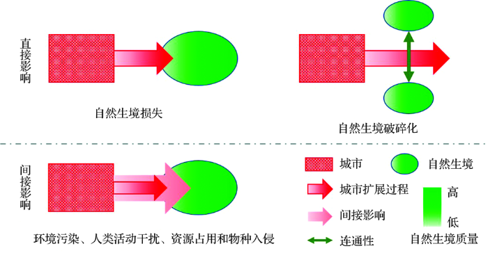
已有研究表明,城市扩展过程会通过直接或间接的方式影响自然生境的面积、空间格局和质量(图1)。首先,城市扩展过程会通过改变区域土地利用/覆盖状况,直接造成自然生境面积的减少[6,12]。其次,城市扩展过程会影响自然生境间的连通性,直接导致自然生境破碎化[5,34,35]。而且,城市扩展过程会加剧环境污染和人类活动干扰,造成自然生境质量下降[36,37,38,39]。城市扩展过程会导致对自然资源占用量增加,进而遏制自然生态系统的正常过程与功能,减少野生动物的食物来源,从而增加种间和种内竞争[40]。另外,城市扩展过程也会增加外来物种入侵的几率,从而威胁本地动植物的生存与繁衍以及自然生态系统的正常演替[40](表1)。
图1 城市扩展过程对自然生境影响的基本原理
Fig.1 The basic mechanisms of the impacts of urban expansion on natural habitats
表1 城市扩展过程对自然生境的影响
Table 1 The impacts of urban expansion on natural habitats
| 类别 | 影响 | 具体表现 | 参考文献 |
|---|---|---|---|
| 直接影响 | 自然生境损失 | 自然生境面积和核心斑块面积减少 | [6,12] |
| 自然生境破碎化 | 自然生境之间连通性降低、隔离度增加和形状不规则等 | [5,34,35] | |
| 间接影响 | 环境污染 | 包括大气污染、水污染、光污染和噪音污染等 | [37,38] |
| 人类活动干扰 | 包括生活垃圾和休憩等 | [36,39] | |
| 资源占用 | 城市居民采伐树木、野生花卉和草药等 | [40] | |
| 物种入侵 | 外来物种入侵和定居等 | [40] |
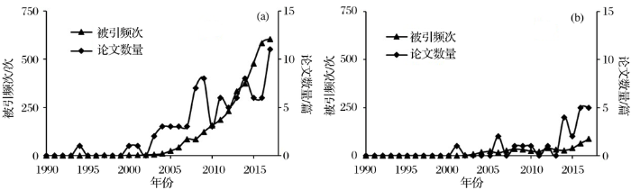
城市扩展过程对自然生境影响评价研究的中英文论文数量和被引频次均呈上升趋势(图2)。中文文献从2001年的1篇上升到2017年的5篇;被引频次从2002年的2次增加到2017年的87次,年均增长5.31次。英文文献从1994年的1篇上升到2017年11篇;被引频次从1995年的1次增加到2017年的605次,年均增长26.30次。相关中文论文主要发表在《生态学报》和《生物多样性》,英文论文主要发表在Landscape and Urban Planning,PLoS ONE,Journal of Environmental Management,Environmental Monitoring and Assessment和Sustainability。
图2 论文数量和被引频次
(a)英文论文;(b)中文论文
Fig.2 Numbers of published papers
(a) English papers; (b) Chinese papers
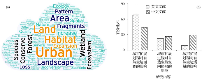
相关研究主要评价了城市扩展过程对森林和湿地等自然生境面积和空间格局的影响(图3)。基于中英文文献的题目、摘要和关键词构建的单词云显示,词频排列前10位的分别是Urban,Land,Habitat,Area,Landscape,Wetland,Conserve,Forest,Ecosystem和Fragments(图3a)。这表明当前城市扩展过程对自然生境影响评价的主要研究对象是森林和湿地,主要研究内容为面积损失和格局破碎化。通过文献统计发现,研究内容主要集中在城市扩展过程对自然生境面积的影响(图3b)。相关文献中研究城市扩展过程对自然生境面积影响的论文共计91篇,占论文总数的88.35%。其中,英文文献76篇,占英文论文数量的91.57%。中文文献15篇,占中文论文数量的65.23%。而且,城市扩展过程对自然生境影响评价的研究还侧重于单一内容的研究,多内容的综合研究相对较少。单一内容的研究论文74篇,占总论文数量的69.81%。
图3 主要研究内容
(a)单词云;(b)相关文献的研究内容
Fig.3 The main research contents
(a)Word cloud; (b) The research content of published papers
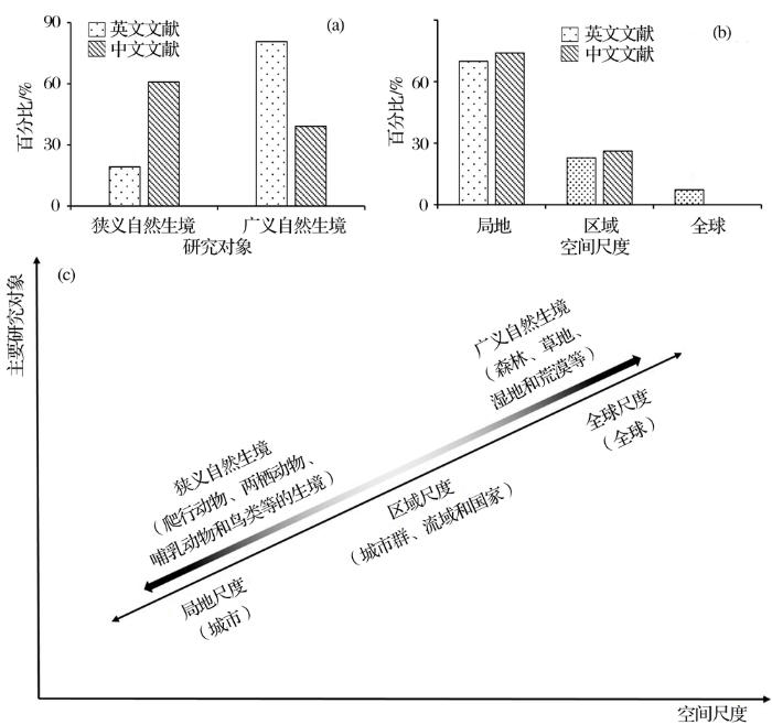
相关文献的研究对象主要为广义自然生境(图4a)。其中,评价城市扩展过程对广义自然生境影响的论文共计76篇,占总论文数量的71.70%。英文文献67篇,占英文论文的80.72%。中文文献9篇,占中文论文的39.13%。进一步统计发现,对森林和湿地等广义自然生境的研究相对较多,分别占广义自然生境研究的37.17%和38.05%。而对狭义自然生境影响的研究中,以鸟类生境为主,占狭义自然生境研究的51.73%。
图4 主要研究尺度和研究对象
(a)已有研究的空间尺度和研究对象;(b)相关文献的研究对象;(c)相关文献的空间尺度
Fig.4 The main spatial scales and organization levels
(a)The main spatial scales and organization levels of existing studies; (b) The organization levels of published papers;(c) The spatial scales of published papers
相关文献的研究尺度主要集中在局地尺度(图4b)。其中,在局地尺度上评价城市扩展过程对自然生境影响的论文共75篇,占总论文数量的70.75%。其中,英文文献58篇,占英文论文数量的69.88%。中文文献17篇,占中文论文数量的73.91%。
不同空间尺度上,研究对象存在差异(图4c)。城市扩展过程对狭义自然生境影响的研究主要在局地尺度上开展,相关论文共22篇,占狭义自然生境研究的73.33%。在区域和全球尺度上,以评价城市扩展过程对广义自然生境的影响为主,相关论文共23篇,占区域和全球尺度研究的74.19%。
当前,城市扩展过程对自然生境影响的研究已初步形成了一套评价流程(图5)。该流程由识别自然生境、理解城市扩展过程和评价城市扩展过程对自然生境影响3个主要部分组成。其中,城市扩展过程对自然生境影响的评价方法可归纳为实地调查法、空间统计法和模型模拟法3类。
图5 城市扩展过程对自然生境影响的评价流程
Fig.5 General procedures for assessing the impacts of urban expansion on natural habitats
实地调查法主要是通过设置调查样区,利用观察、记录和实验等方法获取物种类型、数量、土地利用特征以及水或土壤样品属性等数据,然后结合统计方法评价城市扩展过程对自然生境的影响[41]。例如,Antos等[36]通过实地调查记录鸟类数量,获取城市扩展过程对鸟类生境的影响范围,评价了澳大利亚墨尔本大都市区2004—2005年城市扩展过程对鸟类生境的影响。朱彦等[37]通过实地调查获取了昆明市主城区内多疣狭口蛙的生境数据,结合统计分析方法,评价了城市扩展过程对多疣狭口蛙生境的影响。Croft-White等[38]通过实地调查获取水体样本,结合实验检测手段,评价了城市扩展过程对湿地生境质量的影响。实地调查法的优势主要是能够提供准确的物种数据和生境质量数据,评价结果准确可靠。但是,实地调查法在应用的过程中也表现出一定的局限性。首先,在时间尺度上,实地调查法主要应用于时间较短的研究,长时间的样本观测研究相对较难。其次,在空间尺度上,实地调查法主要应用于空间范围较小的研究区,多以公园、湿地或城市局部为主,在大范围的研究区中调查样本数据相对较难(表2)。
表2 城市扩展过程对自然生境影响的主要评价方法
Table 2 The major methods for assessing the impacts of urban expansion on natural habitats
| 评价方法 | 基本原理 | 优点 | 缺点 | 参考文献 |
|---|---|---|---|---|
| 实地调查法 | 利用观察或采样等方法获取物种数据或样品,结合统计方法或实验检测,评价城市扩展过程对自然生境的影响 | 准确地评价城市扩展过程对自然生境面积和质量的影响 | 难以评价城市扩展过程对自然生境空间格局的影响;空间可视化能力差;研究的空间范围较小 | [36,38,42] |
| 空间统计法 | 利用遥感和地理信息系统技术获取土地利用/覆盖数据,结合空间统计和景观指数等方法,评价城市扩展过程对自然生境的影响 | 快速地评价长时间和大范围的城市扩展过程对自然生境面积和空间格局的影响 | 难以评价城市扩展过程对自然生境质量的影响 | [12,35,43,44] |
| 模型模拟法 | 基于生物多样性评估模型、生态系统过程模拟模型或生态系统服务模型,评价城市扩展过程对自然生境的影响 | 可以评价城市扩展过程对自然生境质量的影响 | 模拟结果难以验证;模型参数获取较难;难以评价城市扩展过程对自然生境面积和空间格局的影响 | [45~47] |
空间统计法主要是通过利用遥感和地理信息系统技术先获取研究区土地利用/覆盖数据,然后结合空间统计和景观指数等方法评价城市扩展过程对自然生境面积和空间格局的影响[48,49]。随着遥感和地理信息系统技术的快速发展,空间统计法已被广泛应用于评价城市扩展过程对自然生境影响[50,51]。例如,He等[12]利用空间统计法评价了中国1992—2012年城市扩展过程对自然生境面积的影响。Yeh等[43]利用空间统计法评价了中国台北1971—2005年城市扩展过程对自然生境面积和空间格局的影响。陈妍等[52]利用空间统计法分析了北京市1990—2010年城市扩展过程对自然生境面积的影响。因为利用遥感和地理信息系统技术能快速地获取大范围和长时间序列的土地利用/覆盖数据,空间统计法可以快速地评价长时间尺度和大范围的城市扩展过程对自然生境的影响。但是,利用空间统计法难以评价城市扩展过程对自然生境质量的影响(表2)。
模型模拟法主要是基于生物多样性评估模型、生态系统过程模拟模型或生态系统服务模型,评价城市扩展过程对自然生境的影响[53]。目前,相关研究以利用InVEST(Integrated Valuation of Ecosystem Services and Tradeoffs)模型评价城市扩展过程对自然生境的影响为主[54]。例如,Wu等[45] 利用InVEST模型评估了中国台湾地区埔里镇城市扩展过程中高速公路建设对自然生境质量的影响。Cao等[46]利用InVEST模型评估了舟山市1995—2011年城市扩展过程对自然生境质量的影响。包玉斌等[55]利用InVEST模型评估了陕西省黄河湿地自然保护区周边2000—2010年城市扩展过程对湿地生境质量的影响。相关研究表明,InVEST模型所需的数据容易获取,能够反映不同生境对威胁源的响应程度以及不同威胁源之间的相互影响,因此能够有效地评估城市扩展过程对自然生境质量的影响[56]。但是,模型模拟法也存在着模拟结果难以验证,模型参数设置没有统一标准以及难以评价城市扩展过程对自然生境面积和空间格局影响等问题(表2)。
在全球尺度上,城市扩展过程对自然生境的影响程度呈增长趋势,这一趋势在非洲和亚洲更为明显。Mcdonald等[5]通过分析1995—2030年全球城市与保护地之间最近距离的变化发现,全球范围内城市与保护地之间的平均最近距离呈下降趋势,其中非洲和亚洲城市与保护地之间的距离下降最快,分别减少33.33%和23.40%。Veach等[57]分析了2000—2040年全球城市扩展过程对生物多样性热点地区、保护地和关键生物多样性地区的影响,结果表明受城市扩展过程影响的生物多样性热点地区、保护地和关键生物多样性地区主要分布在东南亚和非洲的东南部地区。
在区域尺度上,城市扩展过程对自然生境的影响存在明显空间异质性,城市扩展过程对森林和湿地的影响最为明显。Hasse等[58]通过分析1986—1995年美国新泽西州城市扩展过程对自然生境的影响发现,影响的热点地区位于新泽西州的东北、中部和西南以及大西洋沿海平原地区,这些地区的土地利用/覆盖类型以森林和湿地为主。Izquierdo等[59]分析了阿根廷米西奥内斯省2006—2030年不同城市扩展情景对自然生境的影响,结果表明所有情景下影响的热点地区位于北方的6个市,这些地区80%的土地利用/覆盖类型是森林。Ng等[34]分析了中国深圳河流域1988—2008年城市扩展过程对自然生境的影响,结果表明城市隔离指数增长最多的是以森林为主的北部地区,自然生境隔离指数增长最多的是以湿地为主的西部和中部地区。
在局地尺度上,城市扩展过程导致湿地和森林等自然生境面积减少、空间格局破碎化和质量下降。Li等[60]分析了中国武汉市1987—1999年城市扩展过程对自然生境的影响,结果表明湿地和森林面积持续减少,且湿地的斑块数量变化最为强烈,平均斑块面积大幅下降,其次是森林。Dupras等[35]分析了加拿大蒙特利尔大都市区1966—2010年城市蔓延对自然生境连通性的影响,结果表明城市蔓延导致森林的生态连通性持续下降。Antos等[36]分析了澳大利亚墨尔本市城市扩展过程对自然生境的影响,结果表明随着居民区的建设,将有近60%的湿地会受到干扰。包玉斌等[55]分析了中国陕西省黄河自然保护区城市扩展过程对自然生境的影响,结果表明在2000—2005年湿地生境质量退化最为严重。
当前,相关研究在研究内容、分析尺度和评价方法上仍存在一些不足。首先,已有研究多集中于评价城市扩展过程对自然生境面积、空间格局或质量的影响,缺乏综合评价。其次,已有研究多局限于局地尺度,在全球和区域尺度上开展的城市扩展过程对自然生境影响研究仍较少。再次,已有研究主要采用的实地调查法、空间统计法和模型模拟法均存在不足,单独利用某一类方法均难以有效评价城市扩展过程对自然生境的影响。
随着中国新型城镇化与生态文明建设的开展,城市扩展过程对自然生境的影响将成为科学界、政府和公共关注的热点问题。如何有效地评价城市扩展过程对自然生境影响的问题迫在眉睫。通过上述分析可以发现,城市扩展过程对自然生境影响评价存在着尺度效应,即在不同空间尺度上评价方法和研究结果存在差异。因此,为了更加综合全面地理解城市扩展过程对自然生境的影响,我们认为未来应基于“多视角、多尺度和多方法”的综合评价框架开展相关研究(图6)。首先,需要从自然生境面积、空间格局和质量3个方面综合评价城市扩展过程对自然生境的影响。其次,应从多个时间和空间尺度上评价城市扩展过程对自然生境的影响。在时间上,应从影响机理、历史影响和影响趋势等方面认识城市扩展过程对自然生境的影响。在空间上,应从“局地—区域—全球”等多个尺度认识城市扩展过程对自然生境的影响。最后,应结合实地调查法、空间统计法和模型模拟法。利用实地调查法获取精确的模型校正和验证数据,利用空间统计法量化自然生境面积和空间格局变化,利用模型模拟法评价自然生境质量,以此综合评价城市扩展过程对自然生境的影响。
图6 城市扩展过程对自然生境影响的综合评价框架
Fig.6 The comprehensive framework for assessing the impacts of urban expansion on natural habitats
近年来,城市扩展过程对自然生境的影响已受到国内外研究人员的广泛关注,相关研究论文数量和被引频次均呈持续增长趋势。我们发现,已有研究主要采用空间统计法在局地尺度上评价了城市扩展过程对广义自然生境面积与空间格局的影响。这些研究表明,城市扩展过程对森林和湿地的影响较大,而且这一影响在亚洲和非洲呈明显加剧的趋势。相关研究为深入理解城市扩展过程对自然生境的影响奠定了良好的基础,但在评价对象、研究尺度和分析方法等方面仍存在不足。因此,未来需基于“多视角、多尺度和多方法”的思路,开展城市扩展过程对自然生境影响的综合评价研究,以期为改善城市可持续性和保护生物多样性提供帮助。
The authors have declared that no competing interests exist.
| [1] |
Comprehensive evaluation and driving factors of China's urbanization [J].中国城市化水平的综合测度及其动力因子分析 [J].
从城市化内涵的人口、经济、社会、土地四个方面,构建中国城市化水平的综合评价指标体系。基于熵值法,对1981—2006年的中国城市化进行综合测度,结果表明中国城市化综合水平持续提高,以经济增长和地域景观的快速演进为主要特征,其次是人口城市化,最后是社会城市化中的医疗水平,其中各子系统有不同的演变特点。多元回归模型分析表明,城市化动力因子呈现多元化特征,市场力是最主要的驱动力,后面依次是内源力、行政力和外向力。从城市化发展阶段上看,市场力、外向力和行政力对城市化综合水平的影响呈上升趋势,而内源力呈明显下降趋势。本文认为,中国城市化主要是内生过程,应强化市场经济体制改革,统筹城乡发展。
|
| [2] |
|
| [3] |
The niche-relationships of the California Thrasher [J].
'1917 J Grinnell, The California Thrasher. 427 into the body of the partly eaten bantam and replaced it in the same spot where he found it. Next morning the seemingly im- possible was made a practical certainty, for he found the body of a screech owl with the claws of one foot firmly imbedded in the body of the bantam. He very kindly presented me with the owl which, upon dissection, proved to be a female, its stomach containing a very considerable amount of bantam flesh and feathers, together with a great deal of wheat. (It seems probable that the wheat was accidentally swallowed with the crop of the bantam during the feast, but there was so much that it seems strange the owl did not discard it while eating). How a bird only 9.12 inches in length could have dealt out such havoc in so short a time is almost in- credible, but, although purely circumstantial, the evidence against the owl appeared altogether too strong for even a reasonable doubt. The doctor and I wished to make as certain as possible, however, so the poisoned bantam was replaced and left for several days, but without any further results. For the above mentioned reasons I am rather doubtful as to the net value of this owl from an economic standpoint, although birds in a wild state would not give them such opportunities for such wanton killing as birds enclosed in pens. THE NICHE-RELATIONSHIPS OF THE CALIFORNIA THRASHER. 1 BY JOSEPH GRINTSTELL. The California Thrasher (Toxostoma rcdivivum) is one of the several distinct bird types which characterize the so-called "Cali- fornian Fauna." Its range is notably restricted, even more so than that of the Wren-Tit. Only at the south does the California Thrasher occur beyond the limits of the state of California, and in that direction only as far as the San Pedro Martir Mountains and 1 Contribution from the Museum of Vertebrate Zoology of the University of California.
|
| [4] |
|
| [5] |
The implications of current and future urbanization for global protected areas and biodiversity conservation [J]. |
| [6] |
Global forecasts of urban expansion to 2030 and direct impacts on biodiversity and carbon pools [J]. |
| [7] |
Land Cover Change Science/Research Plan, IGBP Report No.35, IHDP Report7[R]. IGBP of the ICSU and IHDP of the ISSC . |
| [8] |
Science Plan and Implementation Strategy [R]. |
| [9] |
Urban effects, distance, and protected areas in an urbanizing world [J].
With rapid global urban growth, the proximity between urban and protected areas will increase. We identify four categories of nations, based on the proportion of people in urban areas, the amount of protected area, and the 1995 and estimated 2030 distance between cities and protected areas: urbanized nations (>60% urban) with a high population density (>40 people/km 2) and close proximity between urban and protected areas (e.g., Europe); urbanized nations with a relatively low population density and moderate proximity between urban and protected areas (e.g., United States); rural nations with a lots of parks (>5% of land area), where proximity will dramatically increase (e.g., China); and rural nations with limited protected area systems (e.g., West Africa). A literature review of 163 studies identified 22 important urban effects on protected areas. Effects range from global to local, with two-thirds of the effects essentially limited to within 50 km of an urban area. We also examined conservation projects of The Nature Conservancy to determine if threats reported by conservation practitioners varied with proximity to urban area. Although many types of threats occurred at all proximities, threat types overall correlated significantly with proximity to an urban area, including more frequent problems with habitat loss due to residential development and wastewater/sewage. Thus, with the median distance from a park to an urban area already less than 50 km in many regions, we conclude that thousands of protected areas are already impacted by urban areas and many more will be impacted in the future.
|
| [10] |
A meta-analysis of global urban land expansion [J].
The conversion of Earth's land surface to urban uses is one of the most irreversible human impacts on the global biosphere. It drives the loss of farmland, affects local climate, fragments habitats, and threatens biodiversity. Here we present a meta-analysis of 326 studies that have used remotely sensed images to map urban land conversion. We report a worldwide observed increase in urban land area of 58,000 km2from 1970 to 2000. India, China, and Africa have experienced the highest rates of urban land expansion, and the largest change in total urban extent has occurred in North America. Across all regions and for all three decades, urban land expansion rates are higher than or equal to urban population growth rates, suggesting that urban growth is becoming more expansive than compact. Annual growth in GDP per capita drives approximately half of the observed urban land expansion in China but only moderately affects urban expansion in India and Africa, where urban land expansion is driven more by urban population growth. In high income countries, rates of urban land expansion are slower and increasingly related to GDP growth. However, in North America, population growth contributes more to urban expansion than it does in Europe. Much of the observed variation in urban expansion was not captured by either population, GDP, or other variables in the model. This suggests that contemporary urban expansion is related to a variety of factors difficult to observe comprehensively at the global level, including international capital flows, the informal economy, land use policy, and generalized transport costs. Using the results from the global model, we develop forecasts for new urban land cover using SRES Scenarios. Our results show that by 2030, global urban land cover will increase between 430,000 km2and 12,568,000 km2, with an estimate of 1,527,000 km2more likely.
|
| [11] |
Future Earth Initial Design: Report of the Transition Team [R]. |
| [12] |
Urban expansion dynamics and natural habitat loss in China:A multiscale landscape perspective [J].
AbstractChina's extensive urbanization has resulted in a massive loss of natural habitat, which is threatening the nation's biodiversity and socioeconomic sustainability. A timely and accurate understanding of natural habitat loss caused by urban expansion will allow more informed and effective measures to be taken for the conservation of biodiversity. However, the impact of urban expansion on natural habitats is not well-understood, primarily due to the lack of accurate spatial information regarding urban expansion across China. In this study, we proposed an approach that can be used to accurately summarize the dynamics of urban expansion in China over two recent decades (1992–2012), by integrating data on nighttime light levels, a vegetation index, and land surface temperature. The natural habitat loss during the time period was evaluated at the national, ecoregional, and local scales. The results revealed that China had experienced extremely rapid urban growth from 1992 to 2012 with an average annual growth rate of 8.74%, in contrast with the global average of 3.20%. The massive urban expansion has resulted in significant natural habitat loss in some areas in China. Special attention needs to be paid to the Pearl River Delta, where 25.79% or 151802km2 of the natural habitat and 41.99% or 76002km2 of the local wetlands were lost during 1992–2012. This raises serious concerns about species viability and biodiversity. Effective policies and regulations must be implemented and enforced to sustain regional and national development in the context of rapid urbanization.
|
| [13] |
Development history and future research priorities of landscape ecology in China [J].中国景观生态学发展历程与未来研究重点 [J].
景观生态学从其诞生到现在,已经历了70余年。中国景观生态学的发展从其引入,到发展、壮大、逐渐成熟,也经历了30余年。在这个发展过程中,中国景观生态学在跟踪国际前沿研究基础上,结合中国实际情况开展了大量研究,在许多研究领域取得了重要进展。简述了国际景观生态学会成立与发展过程,通过系统综述中国景观生态学文献,重点分析了中国景观生态学的发展历程;根据中国景观生态学研究特点,将中国景观生态学发展划分为五个阶段:摸索与酝酿阶段(20世纪80年代以前)、吸收与消化阶段(1980—1988年)、实践与迅速发展阶段(1989—2000)、发展与思索阶段(2001—2010)、思考与创新阶段(2011—?)。在...
|
| [14] |
The framework document of "Future Earth" and the development of Chinese geographical science: The foresight of academician HUANG Bingwei's statement [J].“未来地球”框架文件与中国地理科学的发展——从“未来地球”框架文件看黄秉维先生论断的前瞻性 [J]. |
| [15] |
What is sustainability science [J].什么是可持续性科学 [J].
<p>可持续发展是我们时代的主题,也是人类面临的最大挑战.自20世纪70年代,尤其是近20年来,可持续发展的概念日益频繁地出现在学术文章、政府文件以及公益宣传和商业广告之中.然而,为可持续发展提供理论基础和实践指导的科学——可持续性科学——是在21世纪初才开始形成的.该科学在短短的十几年中迅速开拓、不断发展,正在形成其科学概念框架和研究体系.中国是世界大国,是可持续性科学的哲学思想——“天人合一”——的故乡,有必要承担起时代之重任,在追求“中国梦”的同时促进全球可持续发展,并积极参与进而引领可持续性科学的研究和实践.为了帮助实现这一宏伟而远大目标,本文拟对可持续性科学的基本概念、研究论题和发展前景作一概述.可持续性科学是研究人与环境之间动态关系——特别是耦合系统的脆弱性、抗扰性、弹性和稳定性——的整合型科学.它穿越自然科学和人文与社会科学,以环境、经济和社会的相互关系为核心,将基础性研究和应用研究融为一体.可持续发展的核心内容往往因时、因地、 因人而异.因此,可持续性科学必须注重多尺度研究,同时应特别关注 50到100年的时间尺度和景观以及区域的空间尺度. 景观和区域不但是最可操作的空间尺度,同时也是上通全球、下达局地的枢纽尺度.可持续性科学需要聚焦于生态系统服务和人类福祉的相互关系,进而探讨生物多样性和生态系统过程,以及气候变化、土地利用变化和其他社会经济驱动过程对这一关系的影响.我们认为,景观和可持续性是可持续性科学的核心研究内容,也将是可持续性科学在以后几十年的研究热点.</p>
|
| [16] |
Thoughts on the recent development of physical geography [J].新时代自然地理学发展的思考 [J].
自然地理学是地理学的基础学科,也是地理学综合研究的基石。本文在梳理自然地理学主要研究进展的基础上,思考了新时代自然地理学的发展方向。在全球环境变化驱动下,自然地理学及其分支学科在传承中得到新的发展。自然地理学近年来的研究进展主要表现为自然地理过程综合与深化、陆地表层系统集成、陆海相互作用和区域生态环境管理应用等方面。自然地理学及其分支学科的发展需要面向全球环境变化和人类需求,探索应用新技术新方法,开展多要素多过程集成研究,发展并完善地理模型,模拟和预测环境变化与可持续发展,服务于国家重大需求和政府决策。在发展过程中,亟待关注以下前沿领域与方向:(1)地貌学需要重点加强地貌学与全球环境变化及人类活动关系研究;(2)生物地理学有待深化属性地理学、全球变化生物地理学等前沿领域的探索,连接变化背景下的生物地理空间分布与人类需求;(3)水文学需要开展多要素、多过程、多尺度的综合集成研究,发展生态水文学、社会水文学、水文形态学等新兴学科领域;(4)自然地理学有待全方位介入气候变化研究,在气候变化国际重大研究计划、气候变化框架公约等方面发挥更加积极的支撑功能;(5)综合自然地理需要面向国家重大需求,聚焦人地系统耦合研究,在资源环境承载力评估、生态安全格局与生态文明建设等领域作出积极贡献;(6)自然地理学需深化耦合自然与人文要素及过程研究,建立发展复杂系统模拟模型,分析和模拟变化环境下的自然、人文要素耦合机制和陆地表层系统动态变化规律。
|
| [17] |
Urbanization effects on birds: From community to individual [J].城市化对鸟类的影响:从群落到个体 [J].
Increasing urbanization worldwide resulted in increased human impacts on ecosystems. Urbanization effects on birds have drawn much attention from community to individual. At community level, urbanization impacts on assemblage, species richness, abundance, biomass, biodiversity, etc. were documented; Species level studies indicated the causes underlying bird community patterns in urbanization environment: different species have various responses to urbanization; Recent studies went further to detect urbanization pressures on birds by comparing individuals in behaviors and life history traits between urban environments and native habitats. Many evidences showed that a variety of factors induced with urbanization, including land use change, human disturbance, heat island effect, food change, nest predation, artificial light, etc. contributed more or less to the urbanization effects on birds.
|
| [18] |
Five steps to conducting a systematic review [J].
J R Soc Med. 2003 Mar;96(3):118-21.
|
| [19] |
Formalized synthesis opportunities for ecology: Systematic reviews and meta-analyses [J].
Abstract Top of page Abstract References Narrative reviews are dead. Long live systematic reviews (and meta-analyses). Synthesis in many forms is now a driving force in ecology. Advances in open data for ecology and new tools provide vastly improved capacity for novel, emergent knowledge synthesis in our discipline. Systematic reviews and meta-analyses are two formal synthesis opportunities for ecologists that are now accepted as traditional publications, but the scope of validated syntheses will continue to expand. To date, systematic reviews are rarely used whilst the rate of meta-analyses published in ecological journals is increasing exponentially. Systematic reviews provide an overview of the literature landscape for a topic, and meta-analyses examine the strength of evidence integrated across different studies. Effective synthesis benefits from both approaches, but better data reporting and additional advances in the culture of sharing data, code, analytics, workflows, methods and also ideas will further energize these efforts. At this junction, synthetic efforts that include systematic reviews and meta-analyses should continue as stand-alone publications. This is a necessary step in the evolution of synthesis in our discipline. Nonetheless, they are still evolving tools, and meta-analyses in particular are simply an extended set of statistical tests. Admittedly, understanding the statistics and assumptions influence how we conduct synthesis much as statistical choices often shape experimental design, i.e. ANOVA versus regression-based experiments, but statistics do not make the paper. Current steps primary research articles need to more effectively report evidence, sharing scientific products should expand, systematic reviews should be used to identify research gaps/delineate literature landscapes, and meta-analyses should be used to examine evidence patterns to further predictive ecology.
|
| [20] |
Reprint-preferred reporting items for systematic reviews and meta-analyses: The PRISMA statement [J]. |
| [21] |
The impact of urbanization and climate change on urban temperatures a systematic review [J].
ContextCities have elevated temperatures compared to rural areas, a phenomenon known as the rban heat island . Higher temperatures increase the risk of heat-related mortality, which will be exacerbated by climate change.ObjectivesTo examine the impact of climate change and urban growth on future urban temperatures and the potential for increased heat stress on urban residents.MethodsWe conducted a systematic review of scientific articles from Jan 2000 to May 2016.ResultsThe majority (n = 49, = 86%) of studies examined climate change and the urban heat island in isolation, with few (8) considering their combined effect. Urban growth was found to have a large impact on local temperatures, in some cases by up to 5 C in North-east USA. In some locations climate change increased the heat island, such as Chicago and Beijing, and in others decreased it, such as Paris and Brussels. When the relative impact of both factors was considered, the temperature increase associated with the urban heat island was always higher. Few studies (9) considered heat stress and its consequences for urban populations. Important contributors to urban temperatures, such as variation in urban density and anthropogenic heat release, were often excluded from studies.ConclusionsWe identify a need for an increased research focus on (1) urban growth impact on the urban heat island in climate change studies; (2) heat stress; and, (3) variation in urban density and its impacts on anthropogenic heat. Focussing on only one factor, climate change or urban growth, risks underestimating future urban temperatures and hampering adaptation.
|
| [22] |
A systematic review of urban sustainability assessment literature [J]. |
| [23] |
A review of urban ecosystem services six key challenges for future research [J].
61Quantitative review of peer-reviewed literature on urban ecosystem services.61Research demands clear definitions and recognition of limited transferability.61Stakeholder integration and integrated research approaches are rare to date.61Ecosystem service research should feed findings back into planning and management.
|
| [24] |
Guidelines for systematic review in conservation and environmental management [J]. |
| [25] |
Tendency analysis of socio-hydrology research based on biblimetrics [J].基于文献计量的社会水文学发展态势分析 [J].
社会水文学是一门研究人水耦合系统动态变化规律、服务水资源管理的交叉学科,通过对Web of Science数据库检索到的论文进行文献计量分析,系统综述社会水文学的国际研究发展态势和趋势。分析结果显示,广义的社会水文学研究涉及水资源、环境科学、土木工程、地球科学、环境工程、农学、环境研究、生态学、气象与大气科学、地理学等。国际上长期关注水资源管理、水质、农业灌溉和水政策等问题,不同时期研究的问题热点根据时代发展的水资源管理需求有所变化,不同国家根据国内水资源情势,其关注点也有所不同。狭义的社会水文学研究主要涉及城市化和农村发展的水需求和水安全等问题,强调通过有效的水文模型预测来支持科学管理决策。该学科的发展将会促进人类对水资源的可持续管理和利用,更好地解决人类社会面临的水问题。
|
| [26] |
Eco-environmental effects od urban landscape pattern changes: Progresses, problems, and perspectives [J].城市景观格局演变的生态环境效应研究进展 [J]. |
| [27] |
Research progress and prospect on measuring urban ecological land demand [J].城市生态用地需求测算研究进展与展望 [J].
作为城市地域自然生态系统服务供给的基本载体,生态用地基于土地利用/土地覆被的内在关联将人类社会发展与自然生态演替耦合关联在一起,已成为统筹解决城市建设扩展与自然生态保护矛盾的重要综合途径;城市生态用地的需求测算直接决定供需均衡分析结果,是城乡统筹生态用地规划与管理的关键环节。本文在系统梳理生态用地概念内涵的基础上,对比分析了生态需求与生态用地需求的概念异同;提出基于空间与功能的城市生态用地需求测算概念框架,并据此将已有测算方法归并为经验判定法、生态系统服务法、空间格局法3大类,从综合性、代表性、阈值与规模、位置等方面对比分析了法定定额法、历史趋势预判法、生态足迹法、碳氧平衡法、生态安全格局法等具体方法的基本特征及其优缺点;最后将下一步研究的重点趋向概括为基于土地生态功能的城市生态用地分类、基于土地生态格局的城市生态用地效益综合测算、基于多目标情景的城市生态用地功能综合权衡、基于生态用地供需平衡分析的城市生态腹地识别4个方面。
|
| [28] |
Hydropedology: Interactions between pedologic and hydrologic processes across spatiotemporal scales [J].
Hydropedology is an emerging intertwined branch of soil science and hydrology that studies interactive pedologic and hydrologic processes and properties in the Earth's Critical Zone. It aims to bridge disciplines, scales, and data, connect soils with the landscape, link fast and slow processes, and integrate mapping with monitoring and modeling to provide a holistic understanding of the interactions between the pedosphere and the hydrosphere. This paper reviews major research findings in this field achieved in the past decade (mostly since 2012). A three-dimensional framework (spatial, temporal, and methodological) is used to synthesize recent hydropedological investigations over a broad range of spatiotemporal scales. In spatial dimension, soil architecture, ranging from the microscopic to the megascopic levels, exerts an important control on hydrologic processes and biogeochemical dynamics. In temporal dimension, both short-term soil functioning processes and long-term soil pedogenic processes are impacted by hydrologic processes, and vice versa. In methodological dimension, linking mapping with monitoring, modeling, and managing can accelerate integrated and sustainable use of soil and water resources. Three major challenges are identified for advancing the frontiers of hydropedology, including 1) hierarchical framework for 3-D spatial scale bridging, 2) quantitive linkage for multiple temporal scales, and 3) comprehensive integration for methodological breakthrough. It is hoped that this review can stimulate continuous efforts in advancing hydropedology and integrated soil and water sciences.
|
| [29] |
How much of the world's land has been urbanized, really? A hierarchical framework for avoiding confusion [J].
Urbanization has transformed the world’s landscapes, resulting in a series of ecological and environmental problems. To assess urbanization impacts and improve sustainability, one of the first questions that we must address is: how much of the world’s land has been urbanized? Unfortunately, the estimates of the global urban land reported in the literature vary widely from less than 1–302% primarily because different definitions of urban land were used. To evade confusion, here we propose a hierarchical framework for representing and communicating the spatial extent of the world’s urbanized land at the global, regional, and more local levels. The hierarchical framework consists of three spatially nested definitions: “urban area” that is delineated by administrative boundaries, “built-up area” that is dominated by artificial surfaces, and “impervious surface area” that is devoid of life. These are really three different measures of urbanization. In 2010, the global urban land was close to 302%, the global built-up area was about 0.6502%, and the global impervious surface area was merely 0.4502%, of the word’s total land area (excluding Antarctica and Greenland). We argue that this hierarchy of urban land measures, in particular the ratios between them, can also facilitate better understanding the biophysical and socioeconomic processes and impacts of urbanization.
|
| [30] |
A critical look at representations of urban areas in global maps [J].
According to the UN, the number of urban dwellers is expected to increase from roughly 3.2 billion today to more than 4.9 billion by 2030. An accurate and regularly updated estimate of the extent and spatial distribution of urban land is an important first step in our search for realistic responses to the ecological and social consequences of what promises to be the most rapid urbanization in world history. By employing circa-2000 satellite remote sensing imagery, geographic information systems, and census data, six groups from government and academia in both the EU and the US have created global maps that can be used to describe urban land. We compare these maps from global to sub-national scales, for the first time applying Discrete Global Grids to the problem of global-scale map comparison. Although most of these maps share common data inputs, they differ by as much as an order of magnitude in their estimates of the total areal extent of the Earth's urban land (from 0.27 to 3.52 million km05). A sub-national analysis of the spatial distribution of urban land reveals that inter-map correlations are highest in North America (0202r00= 0.90), intermediate in Europe, South and Central America, and Sub-Saharan Africa (r00 = 0.78), and lowest in Asia (r00 = 0.63). Across most regions, our analysis uncovers a degree of variance that is high enough to call into question the consistency of each group's approach to urban land, pointing to the need for both a common urban taxonomy and a global urban assessment effort.
|
| [31] |
The habitat concept and a plea for standard terminology [J]. |
| [32] |
A multi-scale qualitative approach to assess the impact of urbanization on natural habitats and their connectivity [J].
78 Many environmental assessments inadequately consider habitat loss and fragmentation. 78 Species-perspective for defining habitat quality and connectivity is claimed. 78 Species-based tools are difficult to be applied with limited availability of data. 78 We propose a species-oriented and multiple scale-based qualitative approach. 78 Advantages include being species-oriented and providing value-based information.
|
| [33] |
Habitats Classification Scheme (Version 3.1)[R/OL] . |
| [34] |
Measuring the spatio-temporal variation of habitat isolation due to rapid urbanization: A case study of the Shenzhen River cross-boundary catchment, China [J].
With the expansion of human activities, human-dominated land cover conversion has become the most prominent cause of habitat fragmentation. Urbanization is currently one of the most significant factors driving land conversion and causing habitat fragmentation. Habitat isolation, as one major component of habitat fragmentation, is a dynamic process and complicated to evaluate and quantify. This paper intends to investigate habitat isolation due to rapid urbanization. Two new metrics, Urbanization Isolation Effect ( UIE) and Habitat Isolation Degree ( HID), are proposed to incorporate urban sprawl and population increase into the quantification of habitat isolation, and demonstrate its spatio-temporal variation. The Shenzhen River catchment, a cross-boundary region shared by Hong Kong and Shenzhen SEZ in China, has been used as a case study to demonstrate the effectiveness of these proposed metrics. The results show that (1) extensive land conversion to urban utility has occurred since 1988, especially on the Shenzhen side of the catchment; (2) the metrics of UIE and HID exhibited remarkable spatial and temporal variations in the whole catchment and also displayed a significant discrepancy between Hong Kong and Shenzhen; and (3) urban sprawl on the Shenzhen side exerted trans-boundary influences on habitats of the Hong Kong side. In summary, the two proposed metrics are proved to be effective in demonstrating the spatio-temporal variation of habitat isolation and its causes, as well as identifying the extent and intensity of the urbanization isolation effect. These metrics may be useful for regional planning and natural landscape conservation.
|
| [35] |
The impacts of urban sprawl on ecological connectivity in the Montreal Metropolitan region [J].
Urban sprawl is a widely recognized phenomenon in many major cities worldwide and is a significant land use planning and management issue. This process has many impacts on the ecological function and structure of the landscape. In this article, we analyze the effects of urban sprawl on the ecological patterns and processes in the Montreal Metropolitan Region (MMR) between 1966 and 2010. The dispersed sprawl of low-density urban areas within the territory during this period sharply increased the fragmentation of the territory, isolating the few remaining natural spaces and decreasing their ecological connectivity and, ultimately, biodiversity. The results obtained clearly show that land-use changes that occurred in the MMR have caused profound changes in landscape properties, both structurally and functionally, and especially from 1981 to 2010. In 1966, around 45% of the land had a high or very high level of connectivity, and almost 38% in 1981. By 2010 only 6.5% of the landscape was connected and 73% of the territory possessed no or low connectivity.
|
| [36] |
Unauthorised human use of an urban coastal wetland sanctuary Current and future patterns [J].
Urban expansion brings profound impacts and challenges to many ecosystems, including wetlands. Unauthorised public access to wetland sanctuaries can lead to a number of management problems, such as increasing disturbance to migratory shorebirds. We investigate unauthorised human use of a coastal urban wetland located in Melbourne, Australia, and use current results to predict future patterns of visitation under different management and urban development scenarios. Despite being officially closed to the public, 20.8% of the 574 ha wetland experienced human intrusions during the sampling period. These were most frequent in the section which directly abuts residential development where over 50% of the wetland experienced intrusions. The most frequently observed activities were walking (4.8 4.9 intrusions per observation day), dog walking (8.5 4.5), cycling (3.0 1.8) and motorised trail bike riding (2.5 1.0). There were significant negative relationships between the occurrence of intrusions and distance from the wetland boundary and access points. Walkers and dog walkers were likely to intrude more deeply into the wetlands than other users. We predict that once residential development is completed around the entire perimeter of the wetland that 48% of the total area will be subject to intrusions. This will increase to 58.8% if internal management tracks are opened for public use. We recommend that the current access policy is maintained, and compliance is enhanced through education and additional physical barriers.
|
| [37] |
The effect of urbanization on the habitat of Kaloula verrucosa [J].城市化对多疣狭口蛙生境影响 [J].
城市的扩张是全球发展的一个大趋势,而这一趋势带来的生态影响已成为生态研究的热点。为了探究昆明城市发展对当地多疣狭口蛙(Kaloula verrucosa)生境的影响,于2008年7月与2009年7月使用样方法对昆明市4个主城区内多疣狭口蛙的生境进行了调查,收集生境中的因子数据,将生境分类后对因子数据进行显著性分析比较,结果显示,不同类型生境间除了水体底质、周边地面高度差、人为活动频率以及水泥覆盖度4项因子差异不显著外,其他因子有显著或极显著差异。根据数据分析结果和实地调查分析的结论显示,昆明的城市化发展会对多疣狭口蛙生境产生不利和有利的影响,不利影响包括导致多疣狭口蛙生境丧失、生境恶化和人为影响加剧,而有利影响包括创造新生境、水面覆盖度增加和水体易于迁出。
|
| [38] |
A shoreline divided: Twelve-year water quality and land cover trends in Lake Ontario coastal wetlands [J].
Water quality in Great Lakes coastal wetlands has been studied for decades, but few studies look at water quality changes in multiple sites over many years and relate that to land cover. In this study, water quality at 22 sites in two regions along the north shore of Lake Ontario (Bay of Quinte in the east and Durham Region in the west) was compared over a period of 1202years (2003–2014) and related to land cover data from two time periods (1999–2002 and 2009–2011) at four spatial scales; 50002m, 100002m, 200002m wetland buffers, and the quaternary watershed. Water Quality Index (WQI) scores significantly increased over time in both regions, and turbidity and pH both significantly decreased over time in both regions. Land cover data showed regional differences between east and west, with the western sites having higher percentage of urban land at all scales. There were significant relationships between land cover (% Natural and % Urban) and WQI score at several scales, but the relationships were strongest at the watershed scale. We found that sites in the western region showed a greater amount of change in land cover between the two time periods, compared to the eastern sites. The results of this study provide some key insights on the impact of urbanization on Great Lakes coastal wetlands, and on how they can be managed in the future.
|
| [39] |
Interference intensity of human activities on wintering habitats of black-necked crane in NapahaiWetlands and their patterns [J].人类活动对纳帕海湿地黑颈鹤越冬生境的干扰强度与格局 [J].
快速的城市化进程对城市湿地造成空前的压力,在短期内以人类活动干扰为主要特征;强度各异、来源多样的干扰对以城市湿地为载体的候鸟生境产生的负面影响,影响着候鸟的越冬生境质量,进而影响了候鸟的种群变化。其中,量化人类活动干扰的强度与其对候鸟生境格局的影响是生物保护工作的重要内容之一。纳帕海湿地(Ramsar湿地)是黑颈鹤(Grus nigricollis)中部种群的主要越冬地,然而日趋严重的人类活动干扰已经影响了黑颈鹤种群的越冬生境质量,因而开展这方面的工作是十分必要的。在研究区内,根据黑颈鹤的可利用景观,识别黑颈鹤的潜在生境,结合2010~2015年期间对人类活动干扰源的多次实地调查资料,将影响黑颈鹤生境的主要干扰源进行分类,确定其强度和干扰范围,从而确定2010~2015年期间黑颈鹤实际生境格局及复合干扰位置、强度和范围。研究结果表明,黑颈鹤越冬种群稳定期和迁离期实际生境分别仅占两时期潜在生境的48.9%和38.3%,人类活动干扰是造成黑颈鹤实际生境和潜在生境差异的主要原因;其中,低复合强度干扰的影响面积在稳定期和迁离期都接近总干扰面积的90%,所以,低复合强度干扰是黑颈鹤生境的主要影响因素。因此,控制低复合强度干扰,可以快速、有效地起到保护和恢复黑颈鹤生境的目的。
|
| [40] |
The effects of urban patterns on ecosystem function [J]. |
| [41] |
Habitat use of urban tree sparrows in the process of urbanization: Beijing as a case study [J].城市化对城市麻雀栖息地利用的影响:以北京市为例 [J].
本文以北京市为例研究了城市化水平不同的8个区域中麻雀(<i>Passer montanus</i>的数量分布现状以及影响麻雀分布的栖息地因子。结果表明, 越冬期和繁殖期的麻雀数量均与城市化程度呈显著的负相关关系; 城市化程度高的城市中心商业区、高层居民区和城市主干道中的麻雀数量均很少; 城市化程度较低的城乡结合区、公园、城市的平房区及古建筑区域中麻雀数量均较多; 高校校园和低层楼房居民区, 虽然城市化程度相对较高, 但由于植被较丰富, 麻雀数量也较多。平房面积、针叶树数量、阔叶树数量、空调数量、高层楼房的面积、硬化地面的面积、人流量及车流量是影响麻雀栖息地利用的重要因素。其中平房面积、针叶树、阔叶树、空调的数量增加, 可为麻雀提供栖息条件而有利于麻雀的利用; 硬化地面的面积、高层楼房的面积、人流量及车流量的增加, 由于减少了杂草等麻雀的食物来源并增加了干扰, 不利于麻雀的利用。结果表明, 虽然麻雀是一个适应人类生活环境的物种, 但在快速的城市化变迁中,它已表现出对高度城市化环境的不适应。在城市的规划与建设中, 应考虑到为以麻雀为代表的城市鸟类提供生存必要的植被和繁殖场所, 构建人鸟和谐共存的生态城市。
|
| [42] |
Genetic structure and diversity of the endangered growling grass frog in a rapidly urbanizing region [J].
Two pervasive and fundamental impacts of urbanization are the loss and fragmentation of natural habitats. From a genetic perspective, these impacts manifest as reduced genetic diversity and ultimately reduced genetic viability. The growling grass frog (Litoria raniformis) is listed as vulnerable to extinction in Australia, and endangered in the state of Victoria. Remaining populations of this species in and around the city of Melbourne are threatened by habitat loss, degradation and fragmentation due to urban expansion. We used mitochondrial DNA (mtDNA) and microsatellites to study the genetic structure and diversity of L. raniformis across Melbourne's urban fringe, and also screened four nuclear gene regions (POMC, RAG-1, Rhod and CRYBA1). The mtDNA and nuclear DNA sequences revealed low levels of genetic diversity throughout remnant populations of L. raniformis. However, one of the four regions studied, Cardinia, exhibited relatively high genetic diversity and several unique haplotypes, suggesting this region should be recognized as a separate Management Unit. We discuss the implications of these results for the conservation of L. raniformis in urbanizing landscapes, particularly the potential risks and benefits of translocation, which remains a contentious management approach for this species.
|
| [43] |
Investigating spatiotemporal patterns of landscape diversity in response to urbanization [J].
Landscape patterns in urban regions are usually influenced by human-induced change in land cover in the processes of urbanization. Landscape spatial patterns have profound implications for the functions of ecological systems, and landscape diversity is an effective parameter representing landscape spatial patterns. However, the dynamics of landscape diversity in response to urbanization and its relationships with other aspects of landscape patterns have not been adequately discussed in the context of urban regions. Moreover, the significance of spatial distributions and local differences in landscape diversity within urban regions has received minimal attention. To further understand landscape diversity this study conducted a series analysis of landscape metrics to describe the spatiotemporal pattern of landscape diversity within the Taipei metropolitan region between 1971 and 2005. The landscape metrics were also analyzed to present the characteristics of landscape patterns and examine the correlations of metrics. The dynamics of intra-level landscape diversity in response to urbanization and its relationships with other aspects of landscape patterns were revealed by a series of metric analyses. The spatial distributions and local differences of landscape diversity were revealed to identify the areas where landscape diversity significantly changed in Taipei metropolitan region. This study also identified the regular pattern of landscape diversity in response to the process of urbanization and tested the theory of urban growth.
|
| [44] |
Land use and land cover change in Greater Dhaka, Bangladesh: Using remote sensing to promote sustainable urbanization [J].
This study evaluates land use/cover changes and urban expansion in Greater Dhaka, Bangladesh, between 1975 and 2003 using satellite images and socio-economic data. Spatial and temporal dynamics of land use/cover changes were quantified using three Landsat images, a supervised classification algorithm and the post-classification change detection technique in GIS. Accuracy of the Landsat-derived land use/cover maps ranged from 85 to 90%. The analysis revealed that substantial growth of built-up areas in Greater Dhaka over the study period resulted significant decrease in the area of water bodies, cultivated land, vegetation and wetlands. Urban land expansion has been largely driven by elevation, population growth and economic development. Rapid urban expansion through infilling of low-lying areas and clearing of vegetation resulted in a wide range of environmental impacts, including habitat quality. As reliable and current data are lacking for Bangladesh, the land use maps produced in this study will contribute to both the development of sustainable urban land use planning decisions and also for forecasting possible future changes in growth patterns.
|
| [45] |
Assessing highway's impacts on landscape patterns and ecosystem services: A case study in Puli Township, Taiwan [J].
Highway construction facilitates urban growth in Taiwan. However, the long-term effects of transportation infrastructure are not well understood; these include land-use changes, changes in landscape patterns, and the alteration of ecosystem services. To assess the effects of different land-use scenarios under various agricultural and environmental conservation policy regimes, this study applies an integrated approach to analyze the effects of Highway 6 construction on Puli Township. Interviews with neighborhood leaders of Puli Township, along with remote sensing analysis, reveal that both biophysical and socioeconomic factors are the major forces driving land-use change. The effects of these land-use changes are varied. An example is the road-effect zone, which for Puli Township extends 400m perpendicular to the length of the highway; however, due to differing spatial patterns it is highly asymmetric; indirect effects include the spatial restructuring of certain landscapes, which can drastically influence habitat dynamics. Land-use simulation results indicate that agricultural and environmental conservation policies have significant effects on projected land-use patterns in the southern part of Puli's downtown area and in areas along major roads. Specifically, highway construction and subsequent urbanization under various land-use policies result in varying degrees of isolation and fragmentation in the overall landscape pattern. A habitat quality assessment using the InVEST model indicates that the conservation of agricultural and forested lands improves habitat quality and preserves rare habitats. In summary, appropriate environmental policies will mediate both the direct and indirect impacts of Highway 6 on landscape patterns and ecosystem services in Puli Township.
|
| [46] |
Island urbanization and its ecological consequences A case study in the Zhoushan Island, East China [J].
Islands, which provide multiple ecosystem services, are subject to increasing urbanization pressure due to the ongoing marine development, especially in developing countries. Insights into the island urbanization mechanism and its ecological consequences are essential to sustainable development. In the present paper, the satellite images, nighttime lights, and topographic data were integrated to characterize the spatially explicit urbanization process and mechanism during 1995–2011 in the Zhoushan Island, East China. Furthermore, the corresponding spatially explicit changes in ecosystem services, including net primary productivity (NPP), carbon sequestration and oxygen production (CSOP), nutrient cycling, crop production, and habitat quality, were quantified based on the Carnegie–Ames–Stanford Approach (CASA) and Integrated Valuation of Ecosystem Services and Tradeoffs (InVEST) models. The results showed that the Zhoushan Island had experienced a rapid urbanization over the years, with significant urban encroachment on the farmland and tidal flat. Moreover, the urban land expansion was positively correlated with that of the nighttime lights and negatively correlated with the elevation, slope, and the distance to shoreline. These indicated that the urban expansion was resulted from the enhancement of socioeconomic activities, and concentrated in the near-shore areas with low altitude and gentle slope. The urban encroachment on other land use types resulted in a decrease of 3.402Gg02C02a 611 NPP, 8.702Gg02a 611 CSOP, 13.202Gg02a 611 nutrient cycling, and 12.302t02a 611 crop production, respectively. In addition, the habitat quality in 11% area of this island degraded substantially. Therefore, to achieve sustainable development of islands, it is urgent to implement more stringent policies, such as island spatial regulation, environmental impact assessment, intensive land use, and urban greening, etc.
|
| [47] |
The evaluation for the impact of land use change on habitat quality: A joint contribution of cellular automata scenario simulation and habitat quality assessment model [J]. |
| [48] |
Dynamics of landuse/cover changes and degradation of Nairobi City, Kenya [J].
Landuse/cover in Nairobi City is changing rapidly because of the increased interactions of human activities with the environment as population increases. We used multi-temporal Landsat images (1976, 1988 and 2000) together with physical and socio-economic data in a post-classification analysis with GIS to map landuse/cover distribution and to analyse factors influencing the landuse/cover changes for Nairobi City. An unsupervised classification approach, which uses a minimum spectral distance to assign pixels to clusters, was used with the overall accuracy ranging from 87 per cent to 90 per cent. Landuse/cover statistics revealed that substantial landuse/cover changes have taken place and that the built-up areas have expanded by about 47 km2 over the study period (1976-2000). Forests have decreased substantially while agricultural lands have been on the increase. Rapid economic developments together with the increasing population were noted to be the major factors influencing rapid landuse/cover changes. Urban expansion has replaced agricultural farmlands and other natural vegetation, thereby affecting habitat quality and leading to serious environmental degradation. The random, unplanned growths of environmentally degraded squatter settlements were noted to be emerging in the rural fringes. Successful planning of Nairobi's development will require reliable information about landuse/cover changes and factors influencing such changes. Copyright 2006 John Wiley & Sons, Ltd.
|
| [49] |
Time series of landscape fragmentation caused by transportation infrastructure and urban development: A case study from Baden-Württemberg, Germany [J].
"Landscape fragmentation is increasingly considered an important environmental indicator in the fields of sustainable land use and biodiversity. To set goals for future development and to plan appropriate measures, suitable empirical data on the degree of landscape fragmentation are needed to identify trends and compare different regions. However, there is still a significant lack of data on landscape fragmentation as an indicator, despite the substantial scientific literature on this topic, likely because of confusion over the definition of fragmentation, questions associated with scale and data issues, and lack of general agreement on a fragmentation measure. This study presents a state-wide quantitative analysis of landscape fragmentation in Baden-Wurttemberg, Germany, by means of the effective mesh size (meff), which characterizes the anthropogenic penetration of landscapes from a geometric point of view and is based on the probability that two randomly chosen points in a landscape are connected, i.e., not separated by barriers such as roads, railroads, or urban areas. Baden-Wurttemberg is fragmented to a far greater extent than indicated by previous studies. The meff has decreased by 40% since 1930. This development is strongly related to the growing number of inhabitants, the increased use of motorized vehicles, and the hierarchical regional planning system based on the central place theory. To illustrate the suitability of the meff method for environmental monitoring, as a planning instrument and as an assessment instrument for impact assessment studies, we explored several variations of applying the method with regard to choice of fragmenting elements, consideration of noise bands, spatial differentiation (e.g., administrative districts vs. ecoregions), and way of dealing with patches at the boundaries of the reporting units. Depending on the objectives of the investigation (e.g., recreational quality vs. suitability for wildlife habitat), different variations may be most appropriate. The insights and quantitative results from Baden-Wurttemberg provide a yardstick for analyzing and assessing landscape fragmentation in other countries."
|
| [50] |
Assessment of urban sprawl of Islamabad metropolitan area using multi-sensor and multi-temporal satellite data [J].
Abstract. In addition, the urban growth is accompanied by the loss of forest and other natural habitat in the city and has influenced the spatial patterns and structure of urban development. It is concluded that the remote sensing and GIS techniques supplemented with census data are very efficient and effective for studying the metropolitan growth patterns.
|
| [51] |
Remote sensing roles on driving science and major applications [J].遥感的科学推动作用与重点应用领域 [J].
<p>在调研国内外遥感案例的基础上,论述了遥感在推动地球系统科学发展方面的作用,及在我国的重点应用领域。遥感催生了全球变化研究,使得人类得以从新的视角来探索地球上的生命未来;遥感推动了地球科学从定性到定量、从描述到分析、从单站点到多时空尺度的变革,诸多新兴交叉学科应运而生。遥感是应用驱动的, 一致性及可对比性是定量遥感的核心,也是遥感深化应用的基础。遥感应用于众多领域,但不同的国家基于各自的国情有不同的侧重点,其中,维护国家全球利益、灾害快速响应与灾后评估、第三方独立监督、保障国防安全是我国的应用重点。</p>
|
| [52] |
Effects of land use pattern change on regional scale habitat quality based on In-VEST model—A case study in Beijing [J].基于In-VEST 模型的土地利用格局变化对区域尺度生境质量的影响研究——以北京为例 [J]. |
| [53] |
Spatio-temporal variability of habitat quality in Beijing-Tianjin-Hebei area based on land use change [J].基于土地利用变化的京津冀生境质量时空演变 [J].
土地利用变化是全球变化的核心内容,评估土地利用变化引起的生境质量时空分异性是区域生态规划的基础,能 为土地利用规划和土地管理政策制定提供科学依据.本文在分析京津冀2000-2010年土地利用变化的基础上,以INVEST模型对生境质量进行总体评 估,并基于流域划分,借助剖面线和空间自相关深入分析了生境质量格局时空分异性.结果表明:2000-2010年,研究区主要土地利用变化类型为:耕地转 为建设用地、林地和草地间的相互转换及水体转为耕地,这导致景观结构异质性的减弱和破碎度的提升.两时期生境质量格局整体表现为东南部和南部较低、北部和 西部较高.其中,东南部和南部2010年生境质量明显下降,发生了一定生境退化乃至丧失现象.各流域生境质量具有明显分段特征,较多样点在2010年出现 不同程度退化,但也有部分有所改善.该区生境质量格局空间分布集聚性有所增强.2000年"高高"型生境质量流域空间聚集区为滦河流域和白河流域上游地 区,"低低"型聚集区集中在永定河中下游和潮白河流域部分地区.2010年"高高"型和"低低"型空间聚集区在原有基础上各自向西南方向有所扩展.
|
| [54] |
Development of ecosystem services evaluation models: Research progress [J].生态系统服务功能评估模型研究进展 [J]. |
| [55] |
Effects of land use change on habitat based on InVEST model—Taking Yellow River Wetland nature reserve in Shaanxi Province as an example [J].基于InVEST模型的土地利用变化对生境的影响——以陕西省黄河湿地自然保护区为例 [J].
以陕西省黄河湿地自然保护区为例,采用In VEST评估软件中的生物多样性模型,对保护区生境质量进行评估,并根据生境质量指数将生境划分为低、较低、中、较高和高5个等级,进而研究土地利用变化对保护区生物多样性维持的影响。结果表明:2000—2010年林地、草地和建设用地的面积分别增加了390 hm2、3 380 hm2和1 390hm2,而耕地、湿地和裸地的面积分别减少了4 070 hm2、500 hm2和740 hm2。中等级及以上生境所占比例由2000年的86.19%降低到2010年的14.57%,较低和低等级的生境所占比例由2000年的13.81%增加到2010年的85.43%。建设用地面积的增加和湿地的波动减少是导致生境质量退化的主要原因。2000—2010年是生境质量严重退化的时段,保护区的生物多样性维持功能有所下降。
|
| [56] |
InVEST 3.2.0 User's Guide[Z]. The Natural Capital Project, Stanford University, University of Minnesota, The Nature Conservancy, |
| [57] |
Threats from urban expansion, agricultural transformation and forest loss on global conservation priority areas [J]. |
| [58] |
Land resource impact indicators of urban sprawl [J]. |
| [59] |
Implications of rural-urban migration for conservation of the Atlantic Forest and urban growth in Misiones, Argentina (1970-2030) [J]. |
| [60] |
Land-cover changes in an urban lake watershed in a mega-city, Central China [J]. |

/
| 〈 |
|
〉 |
