Urban Sustainability Evaluation Based on Remote Sensing and Network Data Support: Progress and Prospect
Song Xiaoyu1, , Gao Jun2, Li Xin3, Li Weiyue2, Zhang Zhonghao2, Wang Liangxu2, Fu Jing2, Huang Chunlin1, Gao Feng1
1.Northwest Institute of Eco-Environment and Resources, Chinese Academy of Sciences, Lanzhou 730000,China2.Institute of Urban Study, Shanghai Normal University, Shanghai 200234,China3.Institute of Tibetan Plateau Research, Chinese Academy of Sciences, Beijing 100101,China
First author:Song Xiaoyu(1984-), male, Changchun City, Jilin Province, Assistant Professor. Research areas include ecological economic and environmental policy. E-mail:songxy@llas.ac.cn
The sustainable development of the city is the key to the realization of the global sustainable development goals. Urban sustainability evaluation is a measure to the sustainable development of cities, and basis of sustainable urban development. The current evaluation method is based on statistical data which is low spatial resolution, long period and high cost. In recent years, remote sensing data, network data and the multivariate data have been used for the evaluation for the sustainable development of cities, and there have been many related research cases, which provides a new idea and method to carry out the high resolution evaluation of urban sustainable development rapidly, accurately and cheaply. This article reviewed the remote sensing data and network data in the progress of the application in the evaluation to the sustainable development of cities, and discussed the advantages of remote sensing and network big data in the objectivity, accuracy, and timeliness of evaluation compared with traditional data. Based on the sustainable urban development indicators of the United Nations Sustainable Development Goals (SDG), a basic framework for the evaluation of sustainable development of cities with high temporal and spatial resolution of big data such as remote sensing data and network big data was proposed. The introduction of remote sensing and network big data will change the inherent paradigm of sustainability assessment, make high-resolution real-time evaluation possible, further innovate analytical techniques, improve data accuracy, and make clear the alternative relationship with traditional data being the focus and the only way to realize the replacement of traditional data by remote sensing and network big data.
Keywords:Sustainable development goals
;
Urban sustainable development
;
Remote sensing data
;
Network big data
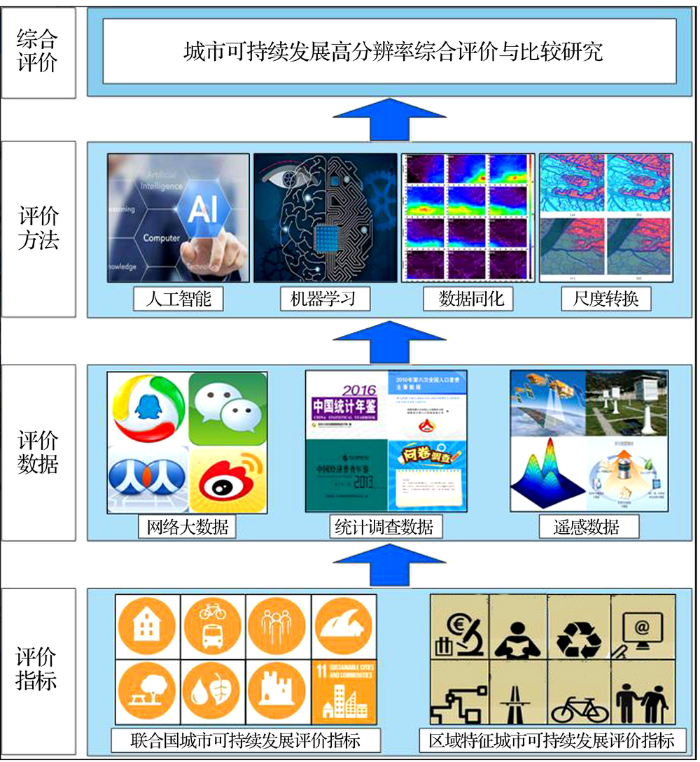
此外,传统城市可持续发展的评价指标体系多样,各类评价侧重点与方法各异,评价结果往往莫衷一是,导致城市间甚至同一城市不同时段的评价结果缺乏可比性,这给判定城市可持续发展水平和识别城市可持续发展问题带来了一定的困难。2015年9月25~27日,在联合国成立70周年之际,联合国193个会员国通过了“改变我们的世界:2030年可持续发展议程”,提出了可持续发展目标(Sustainable Development Goals,SDG),对于人类社会可持续发展做出了新的庄严承诺,提出“让世界走上可持续的、有恢复力的道路。在踏上这一共同征途时,我们保证,不让一个人掉队”。SDG承前启后,在千年发展目标(Millennium Development Goals,MDG)的基础上,制定了2015—2030年的人类社会发展目标,共包括17大类目标,169个具体目标[5]。其中,第11大类目标(SDG 11)是“可持续城市和社区”,即“建设包容、安全、有韧性的可持续城市和人类社区”。SDG城市可持续发展指标囊括了城市社会、经济、环境、安全、制度等诸多方面,通过对上述指标的评价,可以较为完整地刻画一个城市的可持续发展水平。同时这一指标体系为城市不同时期及城市间的可持续发展比较研究提供了一个统一的评价框架。SDG 11的提出,明确了未来15年城市发展的方向,也提供了评价城市可持续发展水平的具体指标,为在统一框架下开展不同城市的评价与比较研究提供了可能。
社交网络大数据反映了公众对于生活和社会状态的满意程度,正是由于“人”作为主动使用者要素的参与,他们在实现对城市可持续发展社会因子(居民行为、公众情绪等)的反演中有着天然的优势,且突破了传统手段调查成本和实验成本高、无法量化社会因子等问题[12]。基于此,有学者利用大量的推特数据构建了一个社会幸福指数(Social Well Being Index,SWBI)作为衡量社会发展水平的重要因子,解决了传统社会调查数据只能通过“被动询问”方式获取的弊端[13]。类似的还有国内幸福指数(Gross National Happiness, GNH)[14]、公平可持续发展指数(Better Life Index, BLI)[15]以及未来趋向指数(Future orientation index)[16]等,都是基于可挖掘的多种网络数据综合构建的社会可持续发展指数。它们都被证明能显著反映地区经济和社会发展水平,可作为反映城市发展和社会福祉的重要替代指标。
2.2 网络大数据在城市公共服务评价方面的应用
城市公共服务在质量和数量上都远远优于乡村,这也是城市这一特定地理空间发挥其空间集约化利用优势的重要方面,是评价一个城市文明发展程度的重要指标。研究者通过访问百度地图等在线地图服务商提供的地理位置信息大数据,为城市公共服务活跃性与可达性指标的计算提供了丰富的数据来源[17],而通过社交网络大数据也可以进行公共服务的满意度评价[18],提取公共服务可达性和满意度等指标。这类评价都是以往基于传统数据无法做到的。房价是关乎城市竞争力和可持续发展的重要指标,网络大数据相较于常规统计数据能够在更精细的时空尺度上实现对这一指标的表达和反演。国外学者基于Google Street View图像内容和描述信息,采用支持向量回归模型构建了收入水平指数,并融入社会经济调查数据推算了纽约、波士顿等地的房价水平指数[13]。国内有房价网等基于海量的土地出让数据、房屋挂牌交易数据等大数据建立的房价数据共享平台。
The Structures Systems of Urban Agglomerations (SSUAs) in China are the spatial and synthetic polymers coupled organically by Urban Agglomerations with different development degrees, grades, political relationship, formative reasons and spatial locations through various flows of substance, power, information and knowledge. Based on the synthetic analysis of the SSUAs at home and abroad, it is found out that world SSUAs are in the process of formation, the functions with different grades for Urban Agglomerations are fabricating profoundly now through new international division of labor and region, and at the same time, although Urban Agglomerations are in the incipient phase as a whole, they are the most vigorous strategic strong point and growth pole with the greatest potential in the economic development framework in the future, and they will dominate the economic development orientation in China. The paper identifies three grades according to the calculating results using of model subject to the index of development degree for Urban Agglomerations in China. The first grade group constitutes Urban Agglomerations on the Yangtze River Delta, Pearl River Delta and of capital Metropolitan Coordinating Region. The second grade consists of 11 Urban Agglomerations in Shandong Peninsula, Chengdu and Wuhan metropolitan coordinating regions. The third grade group is composed of 14 Urban Agglomerations in the central Yunnan Province and the north Tianshan Mountains. Further analyses indicate that there are great differences among the 28 Urban Agglomerations, but such differences are reasonable to some degree. They have showed some characteristics of regional heterogeneities including different development phases, non-equilibrium in overall distribution, regularities in regional heterogeneous pattern, distinct disintegration and heterogeneity in inter-conglomeration. Based on the above analyses, the paper suggests that future studies should focus on the theoretical studies of the multi-dimension, regularity and phase subject of the SSUAs in China, enhance studies on the differences in heterogeneity and competitiveness in the formation and development of the SSUAs and reinforce research on their internationalization, globalization and dynamic monitoring.
[5]
UnitedNations.Transforming Our World: The 2030 Agenda for Sustainable Development A[Z].2015.
Indicators of sustainable development (SDIs), societal progress and wellbeing are perceived as informational tools vital for sustainability governance. The literature has thus far overwhelmingly concentrated on improving the technical quality of the indicators, while the role of these indicators in policy processes remains under-researched. Drawing on literature concerning policy evaluation and assessments—as well as the emerging literature on the interplay between indicators and policy—this article identifies a number of issues central for the role of SDIs in governance processes. It draws attention to the multiple indirect pathways through which these indicators exert their influence, highlighting the conceptual and political roles of SDIs. The conclusions outline a number of trade-offs and ambiguities inherent in the use and development of indicators.
[7]
GomesC P.
Computational sustainability: Computational methods for a sustainable environment, economy, and society
Outsourcing data to external providers has gained momentum with the advent of cloud computing. Encryption allows data confidentiality to be preserved when outsourcing data to untrusted external providers that may be compromised by attackers. However, encryption has to be applied in a way that still allows the external provider to evaluate queries received from the client. Even though confidential database-as-a-service (DaaS) is still an active field of research, various techniques already address this problem, which we call confidentiality preserving indexing approaches (CPIs). CPIs make individual tradeoffs between the functionality provided, i.e., the types of queries that can be evaluated, the level of protection achieved, and performance.In this paper, we present a taxonomy of requirements that CPIs have to satisfy in deployment scenarios including the required functionality and the required level of protection against various attackers. We show that the taxonomy underlying principles serve as a methodology to assess CPIs, primarily by linking attacker models to CPI security properties. By use of this methodology, we survey and assess ten previously proposed CPIs. The resulting CPI catalog can help the reader who would like to build DaaS solutions to facilitate DaaS design decisions while the proposed taxonomy and methodology can also be applied to assess upcoming CPI approaches.
[11]
GlaeserE L, KerrS P, KerrW R.
Entrepreneurship and urban growth: An empirical assessment with historical mines
[J]. Review of Economics and Statistics, 2015, 97(2): 498-520.
Human mobility in a city represents a fascinating complex system that combines social interactions, daily constraints and random explorations. New collections of data that capture human mobility not...
[13]
CurtisL H, BrownJ, PlattR.
Four health data networks illustrate the potential for a shared national multipurpose big-data network
Information in electronic health data that are drawn from large populations of patients is transforming health care, public health practice, and clinical research. This article describes our experience in developing data networks that repurpose electronic health records and administrative data. The four programs we feature are the Food and Drug Administration's Mini-Sentinel program (which focuses on medical product safety), the National Patient-Centered Clinical Research Network (PCORnet, comparative effectiveness research), the National Institutes of Health's Health Care Systems Research Collaboratory Distributed Research Network (biomedical research), and ESPnet (public health surveillance). Challenges to these uses of electronic health data include understanding the factors driving the collection, coding, and preservation of the data; the extensive customization of different systems that collect similar data; the fragmentation of the US health care delivery system and its records; and privacy and proprietary considerations. We view these four programs as examples of the first stage in the of a shared national big-data resource that leverages the investments of many agencies and organizations for the benefit of multiple networks and users.
[14]
DurahimA O, CoᶊkunM.
# iamhappybecause: Gross National Happiness through Twitter analysis and big data
[J]. Technological Forecasting and Social Change, 2015, 99: 92-105.
Long-term and fine-scale satellite monitoring of the urban heat island effect by the fusion of multi-temporal and multi-sensor remote sensed data: A 26-year case study of the city of Wuhan in China
[J]. Remote Sensing of Environment, 2016, 172: 109-125.
... 此外,传统城市可持续发展的评价指标体系多样,各类评价侧重点与方法各异,评价结果往往莫衷一是,导致城市间甚至同一城市不同时段的评价结果缺乏可比性,这给判定城市可持续发展水平和识别城市可持续发展问题带来了一定的困难.2015年9月25~27日,在联合国成立70周年之际,联合国193个会员国通过了“改变我们的世界:2030年可持续发展议程”,提出了可持续发展目标(Sustainable Development Goals,SDG),对于人类社会可持续发展做出了新的庄严承诺,提出“让世界走上可持续的、有恢复力的道路.在踏上这一共同征途时,我们保证,不让一个人掉队”.SDG承前启后,在千年发展目标(Millennium Development Goals,MDG)的基础上,制定了2015—2030年的人类社会发展目标,共包括17大类目标,169个具体目标[5].其中,第11大类目标(SDG 11)是“可持续城市和社区”,即“建设包容、安全、有韧性的可持续城市和人类社区”.SDG城市可持续发展指标囊括了城市社会、经济、环境、安全、制度等诸多方面,通过对上述指标的评价,可以较为完整地刻画一个城市的可持续发展水平.同时这一指标体系为城市不同时期及城市间的可持续发展比较研究提供了一个统一的评价框架.SDG 11的提出,明确了未来15年城市发展的方向,也提供了评价城市可持续发展水平的具体指标,为在统一框架下开展不同城市的评价与比较研究提供了可能. ...
... 此外,传统城市可持续发展的评价指标体系多样,各类评价侧重点与方法各异,评价结果往往莫衷一是,导致城市间甚至同一城市不同时段的评价结果缺乏可比性,这给判定城市可持续发展水平和识别城市可持续发展问题带来了一定的困难.2015年9月25~27日,在联合国成立70周年之际,联合国193个会员国通过了“改变我们的世界:2030年可持续发展议程”,提出了可持续发展目标(Sustainable Development Goals,SDG),对于人类社会可持续发展做出了新的庄严承诺,提出“让世界走上可持续的、有恢复力的道路.在踏上这一共同征途时,我们保证,不让一个人掉队”.SDG承前启后,在千年发展目标(Millennium Development Goals,MDG)的基础上,制定了2015—2030年的人类社会发展目标,共包括17大类目标,169个具体目标[5].其中,第11大类目标(SDG 11)是“可持续城市和社区”,即“建设包容、安全、有韧性的可持续城市和人类社区”.SDG城市可持续发展指标囊括了城市社会、经济、环境、安全、制度等诸多方面,通过对上述指标的评价,可以较为完整地刻画一个城市的可持续发展水平.同时这一指标体系为城市不同时期及城市间的可持续发展比较研究提供了一个统一的评价框架.SDG 11的提出,明确了未来15年城市发展的方向,也提供了评价城市可持续发展水平的具体指标,为在统一框架下开展不同城市的评价与比较研究提供了可能. ...
Making big data work: Smart, sustainable, and safe cities
1
2015
... 社交网络大数据反映了公众对于生活和社会状态的满意程度,正是由于“人”作为主动使用者要素的参与,他们在实现对城市可持续发展社会因子(居民行为、公众情绪等)的反演中有着天然的优势,且突破了传统手段调查成本和实验成本高、无法量化社会因子等问题[12].基于此,有学者利用大量的推特数据构建了一个社会幸福指数(Social Well Being Index,SWBI)作为衡量社会发展水平的重要因子,解决了传统社会调查数据只能通过“被动询问”方式获取的弊端[13].类似的还有国内幸福指数(Gross National Happiness, GNH)[14]、公平可持续发展指数(Better Life Index, BLI)[15]以及未来趋向指数(Future orientation index)[16]等,都是基于可挖掘的多种网络数据综合构建的社会可持续发展指数.它们都被证明能显著反映地区经济和社会发展水平,可作为反映城市发展和社会福祉的重要替代指标. ...
Four health data networks illustrate the potential for a shared national multipurpose big-data network
2
2014
... 社交网络大数据反映了公众对于生活和社会状态的满意程度,正是由于“人”作为主动使用者要素的参与,他们在实现对城市可持续发展社会因子(居民行为、公众情绪等)的反演中有着天然的优势,且突破了传统手段调查成本和实验成本高、无法量化社会因子等问题[12].基于此,有学者利用大量的推特数据构建了一个社会幸福指数(Social Well Being Index,SWBI)作为衡量社会发展水平的重要因子,解决了传统社会调查数据只能通过“被动询问”方式获取的弊端[13].类似的还有国内幸福指数(Gross National Happiness, GNH)[14]、公平可持续发展指数(Better Life Index, BLI)[15]以及未来趋向指数(Future orientation index)[16]等,都是基于可挖掘的多种网络数据综合构建的社会可持续发展指数.它们都被证明能显著反映地区经济和社会发展水平,可作为反映城市发展和社会福祉的重要替代指标. ...
... 城市公共服务在质量和数量上都远远优于乡村,这也是城市这一特定地理空间发挥其空间集约化利用优势的重要方面,是评价一个城市文明发展程度的重要指标.研究者通过访问百度地图等在线地图服务商提供的地理位置信息大数据,为城市公共服务活跃性与可达性指标的计算提供了丰富的数据来源[17],而通过社交网络大数据也可以进行公共服务的满意度评价[18],提取公共服务可达性和满意度等指标.这类评价都是以往基于传统数据无法做到的.房价是关乎城市竞争力和可持续发展的重要指标,网络大数据相较于常规统计数据能够在更精细的时空尺度上实现对这一指标的表达和反演.国外学者基于Google Street View图像内容和描述信息,采用支持向量回归模型构建了收入水平指数,并融入社会经济调查数据推算了纽约、波士顿等地的房价水平指数[13].国内有房价网等基于海量的土地出让数据、房屋挂牌交易数据等大数据建立的房价数据共享平台. ...
# iamhappybecause: Gross National Happiness through Twitter analysis and big data
1
2015
... 社交网络大数据反映了公众对于生活和社会状态的满意程度,正是由于“人”作为主动使用者要素的参与,他们在实现对城市可持续发展社会因子(居民行为、公众情绪等)的反演中有着天然的优势,且突破了传统手段调查成本和实验成本高、无法量化社会因子等问题[12].基于此,有学者利用大量的推特数据构建了一个社会幸福指数(Social Well Being Index,SWBI)作为衡量社会发展水平的重要因子,解决了传统社会调查数据只能通过“被动询问”方式获取的弊端[13].类似的还有国内幸福指数(Gross National Happiness, GNH)[14]、公平可持续发展指数(Better Life Index, BLI)[15]以及未来趋向指数(Future orientation index)[16]等,都是基于可挖掘的多种网络数据综合构建的社会可持续发展指数.它们都被证明能显著反映地区经济和社会发展水平,可作为反映城市发展和社会福祉的重要替代指标. ...
1
2013
... 社交网络大数据反映了公众对于生活和社会状态的满意程度,正是由于“人”作为主动使用者要素的参与,他们在实现对城市可持续发展社会因子(居民行为、公众情绪等)的反演中有着天然的优势,且突破了传统手段调查成本和实验成本高、无法量化社会因子等问题[12].基于此,有学者利用大量的推特数据构建了一个社会幸福指数(Social Well Being Index,SWBI)作为衡量社会发展水平的重要因子,解决了传统社会调查数据只能通过“被动询问”方式获取的弊端[13].类似的还有国内幸福指数(Gross National Happiness, GNH)[14]、公平可持续发展指数(Better Life Index, BLI)[15]以及未来趋向指数(Future orientation index)[16]等,都是基于可挖掘的多种网络数据综合构建的社会可持续发展指数.它们都被证明能显著反映地区经济和社会发展水平,可作为反映城市发展和社会福祉的重要替代指标. ...
1
2012
... 社交网络大数据反映了公众对于生活和社会状态的满意程度,正是由于“人”作为主动使用者要素的参与,他们在实现对城市可持续发展社会因子(居民行为、公众情绪等)的反演中有着天然的优势,且突破了传统手段调查成本和实验成本高、无法量化社会因子等问题[12].基于此,有学者利用大量的推特数据构建了一个社会幸福指数(Social Well Being Index,SWBI)作为衡量社会发展水平的重要因子,解决了传统社会调查数据只能通过“被动询问”方式获取的弊端[13].类似的还有国内幸福指数(Gross National Happiness, GNH)[14]、公平可持续发展指数(Better Life Index, BLI)[15]以及未来趋向指数(Future orientation index)[16]等,都是基于可挖掘的多种网络数据综合构建的社会可持续发展指数.它们都被证明能显著反映地区经济和社会发展水平,可作为反映城市发展和社会福祉的重要替代指标. ...
百度地图API 在引力可达性模型中的应用
1
2015
... 城市公共服务在质量和数量上都远远优于乡村,这也是城市这一特定地理空间发挥其空间集约化利用优势的重要方面,是评价一个城市文明发展程度的重要指标.研究者通过访问百度地图等在线地图服务商提供的地理位置信息大数据,为城市公共服务活跃性与可达性指标的计算提供了丰富的数据来源[17],而通过社交网络大数据也可以进行公共服务的满意度评价[18],提取公共服务可达性和满意度等指标.这类评价都是以往基于传统数据无法做到的.房价是关乎城市竞争力和可持续发展的重要指标,网络大数据相较于常规统计数据能够在更精细的时空尺度上实现对这一指标的表达和反演.国外学者基于Google Street View图像内容和描述信息,采用支持向量回归模型构建了收入水平指数,并融入社会经济调查数据推算了纽约、波士顿等地的房价水平指数[13].国内有房价网等基于海量的土地出让数据、房屋挂牌交易数据等大数据建立的房价数据共享平台. ...
A global map of travel time to cities to assess inequalities in accessibility in 2015
1
2018
... 城市公共服务在质量和数量上都远远优于乡村,这也是城市这一特定地理空间发挥其空间集约化利用优势的重要方面,是评价一个城市文明发展程度的重要指标.研究者通过访问百度地图等在线地图服务商提供的地理位置信息大数据,为城市公共服务活跃性与可达性指标的计算提供了丰富的数据来源[17],而通过社交网络大数据也可以进行公共服务的满意度评价[18],提取公共服务可达性和满意度等指标.这类评价都是以往基于传统数据无法做到的.房价是关乎城市竞争力和可持续发展的重要指标,网络大数据相较于常规统计数据能够在更精细的时空尺度上实现对这一指标的表达和反演.国外学者基于Google Street View图像内容和描述信息,采用支持向量回归模型构建了收入水平指数,并融入社会经济调查数据推算了纽约、波士顿等地的房价水平指数[13].国内有房价网等基于海量的土地出让数据、房屋挂牌交易数据等大数据建立的房价数据共享平台. ...
Long-term and fine-scale satellite monitoring of the urban heat island effect by the fusion of multi-temporal and multi-sensor remote sensed data: A 26-year case study of the city of Wuhan in China

 , 高峻
, 高峻
