
刘江艳 , 张昌民
, 张昌民
Liu Jiangyan, Zhang Changmin
中图分类号: P512.2
文献标识码: A
文章编号: 1001-8166(2018)01-0066-09
收稿日期: 2017-09-18
修回日期: 2017-11-7
网络出版日期: 2018-01-10
版权声明: 2018 地球科学进展 编辑部
基金资助:
作者简介:
First author:Liu Jiangyan(1988-),female,Lingbao City, He’nan Province,Ph.D student. Research areas include reservoir sedimentology.E-mail:jiangyan19880312@163.com
作者简介:刘江艳(1988-),女,河南灵宝人,博士研究生,主要从事储层沉积学研究.E-mail:jiangyan19880312@163.com
展开
摘要
涌潮是在涨潮过程中潮波向上游方向行进的水跃现象,广泛存在于潮差大、平面上呈喇叭状的河口地区。研究涌潮沉积对了解河口湾区域的古气候、古环境、古地貌具有重要意义,且现代沉积研究表明涌潮沉积形成的砂体具备形成优良油气储层的潜力。然而一直以来关于涌潮的研究主要集中在其水力学特征以及对河口生态、工程造成的影响等方面,对涌潮沉积却涉及甚少。在对近年来国内外关于涌潮沉积研究的有代表性的论著综合分析基础上,从涌潮沉积构造、粒度分布、沉积模式等方面论述了涌潮沉积的鉴别标志,探讨目前研究中存在的主要问题,认为后期研究应综合多种研究手段对涌潮沉积模式进行完善,加强涌潮沉积砂体成岩作用及储层特征研究。旨在引起人们对涌潮沉积研究的重视,为涌潮沉积未来的研究提供方向。
关键词:
Abstract
Tidal bore is hydraulic jump during the process of tide flooding with the tide wave moving upstream. They are widely distributed in the estuary zone with high tidal range and funnel-shaped planeform. Tidal bore deposit study is important for further understanding about paleogeomorphology, paleoenvironment, paleoclimate of areas near the estuaries, and sandbody formed by tidal bore deposit could be potential oil and gas reservoir. Researches about tidal bore have been always concentrated on hydraulic characteristics of tidal bore and its influences on estuary environment and engineering, while the study on tidal bore deposit is rarely reported. One of the most important causes is the complex hydrodynamic conditions in the estuary zone. Deposits characteristics is complicated in this zone due to comprehensive effects of river flow, waves and tides. It is hard to affirm the preservation probability of tidal bore deposits, especially in the ancient rock record. In view of this, current status and forecast about tidal-bore deposit study were expounded in this study based on comprehensive summary and discussion about typical tidal bore deposit data and reports. Criteria for recognition of tidal-bore deposits were described in detail on the aspects of sedimentary structures, grain size distribution, and facies model. One of the most critical diagnostic marks of tidal bore was a special undulating erosion surface with a series of irregular and stepped excavations on it. This surface was formed by cyclic pressure loading induced by the passage of a tidal bore. In addition, the cross-bedding inclined upstream, soft sediment deformation structures and massive sandstone on the erosion surface were also important marks of a tidal bore deposit. Problems existing in current research were discussed and some suggestions were proposed. Various methods and technology should be used to perfect tidal bore facies model, and research on diagenesis and reservoir features of sandbody formed by tidal bore should be strengthened in the future. Sandbody formed by tidal bore of different types (breaking tidal bore and undular tidal bore) should be distinguished to deepen the understanding of their various hydrodynamic conditions and reservoir scale. Tidal bore is significant geological process in estuary zone, and deposits formed by it makes great influence on the geomorphology of this area, which should be paid more attention.
Keywords:
涌潮(tidal-bore)是在涨潮过程中潮波向上游方向行进的水跃现象,主要发生在潮差大、平面上呈喇叭状或有水下沙坎的河口或海湾地区[1~12]。世界上至少有80个河口或海湾地区会发生涌潮,较为著名的有中国钱塘江涌潮、长江北支涌潮、巴西的亚马逊河口涌潮、阿拉斯加“回头湾”(Turnagain Arm)涌潮等[2,3,8,13]。研究涌潮沉积对了解河口地区的古环境、古地貌、古气候等具有重要意义,且涌潮沉积形成的砂体在经历埋藏、成岩作用后可能会形成有利油气储层。一直以来研究人员关于涌潮的研究重点主要集中在以下几个方面:①关于涌潮形成的数值模拟:这些数值模拟从最早时期的一维模拟不断改进到三维模拟,建立了不同模型来表征不同潮汐类型的形成过程[11,14~26];②针对涌潮形成过程开展的水槽模拟实验:这些模拟实验主要对涌潮的形成过程及水深、潮差、底部摩阻、潮波波长等多个参数对其形成的影响进行了探讨和验证[27~31];③基于野外实测、室内实验开展的涌潮形成过程中水动力学特征及其对沿岸地貌、工程及环境造成的影响等[9,32~36],对涌潮沉积的研究涉及甚少。造成这种结果的原因是多方面的,主要是由于在河口这种潮汐、波浪、河流等水体共同作用的复杂环境中,沉积物特征复杂,且涌潮事件一般持续时间相对较短,作用相对有限。沉积物保存率难以确定,使得有效识别涌潮沉积物难度较大,尤其是在古代地层记录中。鉴于此,本次研究在对国内外近年关于涌潮沉积研究的有代表性的论著进行综合分析的基础上,总结了涌潮沉积的主要识别标志并论述了其形成机理,探讨了涌潮沉积研究的古环境及油气勘探意义,分析了目前研究中存在的主要问题并对今后的研究方向提出了建议,以引起人们对涌潮沉积的重视,加深对涌潮沉积的认识,为涌潮沉积的后续研究提供依据。
涌潮一般发生在潮差大(4 m以上)、平面上呈喇叭状的河口湾地区[1~12,37,38],鉴于其形态及能量强度差异,一般分为漩滚涌潮和波状涌潮。通过对现代沉积及古代地层记录中已发现的涌潮沉积构造进行总结(表1),作者归纳出以下几种有效识别涌潮沉积的典型沉积构造,并分析了不同沉积构造成因机制。
表1 现代沉积及古代岩石记录中已识别的涌潮沉积构造
Table 1 Depositional structures induced by tidal-bore that has been recognized in modern and ancient strata
| 观察到涌潮沉积的 河口湾(或剖面) | 沉积构造类型 | 参考文献 | |||||
|---|---|---|---|---|---|---|---|
| 冲刷 构造 | 块状 层理 | 递变 层理 | 倾向上游的 交错层理 | 双向交 错层理 | 软沉积物 变形构造 | ||
| 阿拉斯加Turnagain Arm 河口湾 | + | + | - | - | - | ++ | [39] |
| 美国堪萨斯州东北部晚宾夕法 尼亚世Echo Cliff剖面 | ++ | + | - | - | - | - | [12] |
| 葡萄牙西部卢西坦盆地晚 侏罗世Lourinha组剖面 | ++ | ++ | - | ++ | + | - | [9] |
| 长江古河口湾 | ++ | ++ | - | - | - | - | [13,40] |
| 钱塘江河口湾 | ++ | ++ | + | - | + | ++ | [1,41,42] |
| 法国Mont-Saint-Michel河口湾 | + | - | - | - | - | ++ | [43] |
| 爱沙尼亚西北部寒武系Tiskre 组潮汐沉积剖面 | + | + | - | - | - | ++ | [44] |
(1)波状冲刷构造:为涌潮沉积的诊断性构造。
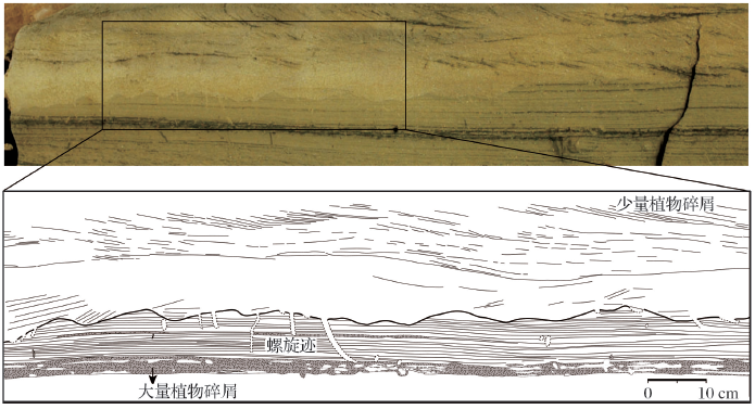
涌潮发生过程中,潮头以及尾随其后的子波都会对河床产生冲刷作用,形成大量的冲刷构造。这种冲刷构造与河流中被细粒沉积物包围的水道底部冲刷面不同,具有特殊的冲刷形态,这些冲刷面上“具有一系列阶梯式、不对称、不规则的凹坑,凹坑宽度一般小于0.3 m,深度不超过0.15 m,这些凹坑波长较短、振幅相对较高,部分边缘较陡,凹坑陡面的倾向与主河道运移方向一致” [9,12](图1)。从平面位置上看,这种冲刷面基本都出现在距离河口几十公里远的河口上游区域[9,12]。在一些现代涌潮沉积的岩芯中也可观察到涌潮沉积的块状砂岩底部具有很多特殊形态的冲刷面[10,45~47]。这种明显的波状冲刷面及其特殊的冲刷形态是涌潮经过时造成的周期性压力载荷所致。Donnelly等[45]通过水槽实验模拟从流体力学角度论述了这种冲刷面的形成机理,认为在涌潮发生过程中,越靠近河床部位,流速波动越大,在涌潮波向上游行进的过程中河床会受到频繁的流体加速和减速的影响,使得河床要经受循环性的压力载荷作用以及压力反转的影响,从而形成了这种形态特殊的波状冲刷面。值得注意的是,虽然在涌潮沉积产物中都观察到了这种特殊形态的冲刷构造,但是在不同区域其上下地层的特征却并不完全相同,这是由不同区域平面上发育的沉积类型不同导致的,在具体研究过程中应该结合某一区域的沉积特征具体分析涌潮沉积物与上下地层之间的叠置关系。但不可否认的是,这种特殊的冲刷面是涌潮沉积的重要识别标志。
图1 葡萄牙西部卢西坦盆地晚侏罗世Lourinha组Praia de Areia Branca剖面中涌潮成因的波状冲刷构造(据参考文献[9]修改)
可看到冲刷面上覆砂岩中指示倾向上游的交错层理以及下伏地层中发育的Taenidium(螺旋迹)生物遗迹,有些生物遗迹被冲刷面切割
Fig.1 Example of an undulating erosion surface at Praia de Areia Branca of Late Jurassic Lourinha Formation in Lusitanian Basin, Western Portugal (modified after reference [9])
The reversed flow directions above the erosion surface and the Taenidium barreti burrows, some burrows were truncated by the erosion surface
(2)块状层理或递变层理:与波状冲刷面一起,是判别涌潮沉积的诊断性特征。涌潮沉积的砂岩主要为块状层理[1,9,10,12,13,41,47],偶尔也可见递变层理[10],多披覆沉积在之前形成的底部冲刷面上(图1)。这是由于涌潮发生时,大量细粒泥沙被紊动剧烈的潮流携带着向上游方向运移,涌潮过后,流速骤降,大量悬浮沉积物快速沉积下来,披覆在之前形成的冲刷面之上。偶尔也可见不明显的递变层理,这是由于沉积过程中较粗的颗粒会先沉积下来[10]。
(3)指示反向水流方向的交错层理:多沿着冲刷面分布,或在冲刷面上部块状砂岩中可见向上游倾斜的指示反向水流特征(与河流流水方向相反)的层理构造(图1)。有的涌潮沉积砂体中可见双向交错纹层,是潮汐及流水双向水流作用的结果[9,12]。倾向上游的交错层理反映了在涌潮发生及其过后的较短时间内,河流能量相对较弱、向上游方向行进的高振幅潮波能量占主控地位。
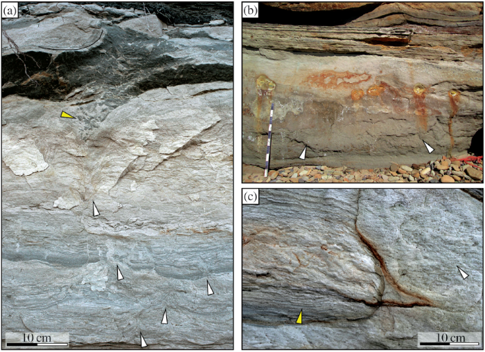
(4)软沉积物变形构造:一直以来软沉积物变形构造大多被认为是地震或海啸等事件触发尚未固结成岩的沉积物发生变形所形成的[48~50],但是有些学者在深入研究过程中发现在涌潮河段形成的一些以往认为是地震成因的软沉积物变形,实际上是涌潮沉积所形成的。包括泄水构造、火焰状构造、包卷层理、碟状构造、负载构造、滑塌构造等(图2和图3)[41~44]。野外实测发现,这些软沉积物变形构造可在一天的涨潮落潮过程中形成,是对涌潮造成的河床底部剪切应力变化的直接响应,也可能是涌潮发生过程中流速骤降时潮滩上产生超压继而引起未固结的沉积物发生变形,并非是地震等其他原因触发的变形。范代读等[10,42]和涂俊彪等[41]在钱塘江涌潮沉积物中发现大量软沉积物变形构造,其中除了正常的“向上”的泄水构造,还可见“向下”的泄水构造,推测是潮头经过时产生向下的强大冲击力的直接反映,而当涌潮过后,上部压力减小,则会形成正常的“向上”的泄水构造;以及重力作用与砂层液化共同作用所形成的负载、断折与滑塌构造。Põldsaar等[44]在爱沙尼亚西北部寒武系不同露头Tiskre组也发现了大量涌潮成因的泄水构造、小型褶皱或包卷层理。这些发现为河口环境中大量出现的软沉积物变形构造的成因提供了多解性,为合理解释不同类型软沉积物变形构造提供了依据。
图2 爱沙尼亚西北部寒武系不同露头Tiskre组涌潮成因的泄水构造(据参考文献[44]修改)
(a)Muraste露头小型泄水通道组成的泄水网络,白色箭头指示单个的泄水通道,黄色箭头指示自生碎屑角砾岩;(b)Ninamaa露头块状的厚层粉砂岩,白色箭头指示发生液化变形的沉积物,图中的比例尺高为1 m;(c)Muraste露头的均质粉砂岩,左边的黄色箭头指示保存下来的潮汐纹层,右边的白色箭头指示泄水构造,均质砂岩的原始层理已经被泄水构造完全破坏
Fig.2 Dewatering structures triggered by tidal bore within the Tiskre Formation of different outcrops(modified after reference [44])
(a)Muraste outcrop section, small water-escape channels network (white arrows point to individual small channels), and autoclastic breccia (yellow arrow). (b)Ninamaa outcrop section, massive thick-bedded siltstone unit, liquefied sediment is indicated with white arrows, the stick on the picture is 1 m. (c)Homogeneous siltstone unit of Muraste outcrop, sediment on the left side of the photo retains tidal lamination (yellow arrow) while right side is largely homogenized and no original lamination is preserved
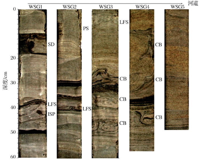
图3 中国钱塘江河口湾WSG剖面低—中潮滩涌潮及与其伴生的沉积岩芯特征(据参考文献[42]修改)
SD为砂质岩脉;LFS为负载—火焰状构造.ISP为侵入的砂质团块.PS为碟状构造.CB为包卷层理
Fig.3 Core photos of WSG section show typical sedimentary structures produced by tidal bores and associated processes at the lower-middle tidal flats(modified after reference[42])
SD:Sand Dikes. LFS: Load-Flame Structures. ISP: Invasive Sand Patches. PS: Pipe-like Structures. CB: Convolute Bedding
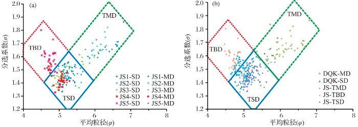
在有些涌潮沉积典型构造不明显的区域,单纯利用岩性和沉积构造无法有效区分涌潮及常规潮汐沉积物。关于这个问题,目前比较有效的方法是范代读等[10]提出的依靠粒度参数判别法对这2种不同沉积过程下的沉积物加以区分。从平均粒径分析结果看,涌潮沉积>潮成砂岩>潮成泥岩(图4),这是因为涌潮沉积的砂体是在潮头过后流速骤降时快速沉积所形成的,其粒度较潮成砂岩更粗。从分选系数特征看,潮成泥岩>涌潮沉积>潮成砂岩(分选系数越大,分选越差)(图4),由于潮成砂岩是在涌潮过后,水流波动小、沉积作用较为平缓的环境下形成的,分选最好;涌潮沉积物为强水动力的产物,且主要是由悬浮泥沙快速沉积所形成的,分选性较差;而潮成泥岩是在流速极低的情况下悬浮组分沉积而成,分选最差。
图4 中国钱塘江北部边滩涌潮与常规潮汐沉积粒度参数散点图(据参考文献[10]修改)
(a)尖山断面粒度参数平均粒径与分选系数散点图; (b)大缺口断面粒度参数平均粒径、分选系数在尖山断面解析图上投点;TBD代表涌潮沉积; TSD代表潮成砂质沉积; TMD代表潮成泥质沉积. SD, MD分别代表砂、泥质沉积
Fig.4 The grain size parameter plot distinguishing between tidal and tidal-bore deposit in northern flat of Qiantang River in China based on mean and sorting values of the samples (modified after reference [10])
(a)Jianshan-section. (b)Daquekou-section. TBD:Tidal Bore Deposits. TSD:Tidal Sandy Deposits.TMD:Tidal Muddy Deposits. SD:Sandy Deposits. MD:Muddy Deposits
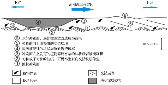
Fielding等[12] 在美国堪萨斯州东北部的Echo Cliff砂岩中发现了涌潮沉积并结合Martinius等[9]和范代读等[42]的研究成果首次建立了涌潮沉积相模式(图5)。认为涌潮沉积主要发育以下4个沉积单元。
(1)波状起伏的底部或顶部冲刷面:与前文述及的波状冲刷面特征相似,不同的是, Fielding等[12]模式中的冲刷面有时会被潮波不断改造成为对称或不对称的波痕。在Echo Cliff剖面观察到的很多冲刷面的波长远远小于涌潮潮头的波长,认为这里的冲刷面可能是尾随在潮头之后的“子波”冲刷作用的结果。在后期研究中可以依靠冲刷面的波长、波高、振幅等具体参数特征来判别不同冲刷构造的具体成因。
(2)对称或不对称的波痕:受涌潮波的多次改造,最初形成的底部冲刷面局部会被改造成为对称或不对称的波痕(图6a,b)。波痕内部可观察到小型的双向交错纹层,反映双向水流的存在[12]。波痕不对称的形态反映了涌潮发生时强潮携带沉积物向上游搬运的特征。
(3)冲刷面上部发育的披覆沉积:以粉砂岩、细砂岩为主,披覆在之前形成的冲刷面之上,是涌潮沉积的主体。Echo Cliff露头中发现的披覆沉积包括2种不同特征的砂岩。分别为植物碎屑富集的块状细砂岩层和块状泥质砂岩层,这些砂质沉积物底部都可见不同规模的冲刷面,砂岩在平面上呈相互切割的透镜状(图6a,c)。这2套砂质沉积物都是在受潮汐影响的古河流中,多次涌潮事件对河流中正在发育的点坝产生冲刷或侵蚀作用,促使点坝沉积物及部分河床上的沉积物再悬浮之后沉积而成。这些砂质沉积底部冲刷面的波长均远远小于涌潮潮头的波长以及这些砂岩透镜体本身的波长,因此认为其底部冲刷面都是由尾随在涌潮潮头之后的“子波”(whelps)冲刷所形成的,而位于冲刷面上部的砂质披覆沉积则是下一期涌潮潮头经过的几十分钟后,流速骤降,原来携带的部分点坝沉积物及部分河床上的沉积物快速沉积而形成[12]。冲刷作用的发生时间早于这些砂质透镜体的沉积时间。
图5 涌潮沉积相模式图(据参考文献[12]修改)
Fig.5 Facies model of tidal-bore deposit(modified after reference [12])
(4)向上游倾斜的交错层理:在涌潮发生及其过后的较短时间内,河流能量相对较弱,向上游方向的潮流作用占主控作用时形成。局部会出现双向交错纹层,为河流与潮流双向水流相互作用的结果[2,3,9,12]。
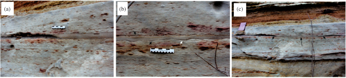
图6 美国堪萨斯州东北部晚宾夕法尼亚世Echo Cliff露头中的涌潮沉积特征(据参考文献[12]修改)
(a)泥质砂岩透镜体东北缘近照特征,可见底部和顶部冲刷面的圆齿状特征;(b)涌潮沉积的块状泥质砂岩局部特征,可见顶底冲刷面在潮波的不断改造下已成为对称或不对称的波痕(黑色箭头),白色箭头指示的是保留下来的局部下伏地层;照片中的粉色比例尺卡片高0.3 m,黑白色比例尺长0.15 m;(c)透镜状的泥质砂岩(短箭头指示透镜体边缘,长箭头指示透镜体的长轴)切割之前沉积的植物碎屑富集的块状砂岩
Fig.6 Tidal-bore deposit of Upper Pennsylvanian Echo Cliff outcrop of northeastern Kansas, USA(modified after reference [12])
(a)Close-up view of the northeastern of the muddy sandstone lens and the scalloped nature of basal and top surfaces.(b)Close-up of the bore deposit, showing structureless, muddy sandstone bounded by surfaces that have been reworked into symmetrical and asymmetrical ripples (black arrows). Note the partial preservation of a lower bed in the right side of the view (white arrow). The pink clipboard is 0.3 m high, the scale bar is 0.15 m long.(c)A lens-shaped body of structureless, muddy sandstone (short arrows indicate margins, long arrow indicates axis) cutting through previously deposited plant-debris-rich, structureless sandstone
Fielding等[12]建立的相模式是该地区在短时间内经受了多次涌潮作用的结果。虽然在建立模式时综合了前人研究的涌潮沉积的其他特征,但是这个相模式仍然具有局限性,且作者在研究过程中未考虑涌潮沉积的保存率及侵蚀能力问题,对砂体规模未做有效论述,无法反映涌潮类型,因而不能作为涌潮沉积的标准相模式。
涌潮沉积过去一直被研究人员所忽视,本文对其亟待解决的几个问题提出建议,为后期研究提供方向。
(1)涌潮沉积的鉴别标志和相模式不完善
建议研究手段应多样化,在对野外露头岩石学特征开展精细分析的基础上,应结合地震资料、测井资料、地球化学资料全面分析涌潮沉积特征;依靠物理实验模拟(如水槽模拟)、数值模拟等方式,再现涌潮沉积过程及沉积结果,分析涌潮发生过程中携带沉积物及侵蚀沉积物的能力,探讨涌潮沉积的主控因素;并结合与现代沉积的对比,对涌潮沉积的特征及鉴别标志做出更系统的分析,为建立更完善的涌潮沉积相模式提供可靠依据。
(2)不同形态涌潮产生的沉积物类型及规模未做有效区分
波状涌潮与漩滚涌潮在形成过程中,水动力强度及流体条件存在差异,携带沉积物的能力及侵蚀能力不同,可能会形成具有不同特征的冲刷构造,沉积的砂体在粒度、厚度、规模上也可能存在差异,形成油气有效储层的概率也会不同。应结合水槽实验及野外实测,对不同类型涌潮条件下对沉积物侵蚀能力、沉积物保存率及沉积砂体规模进行有效区分。
(3)对涌潮沉积的成岩作用特征及其含油气性的研究还很薄弱
钱宁等[1]早在20世纪60年代就对钱塘江涌潮沉积的砂体进行了研究,认为钱塘江涌潮沉积的沙坎规模巨大,主要为分选很好的粉细砂,长达130 km,厚度可达10 m以上;李从先等[13]和李保华等[40]也报道了全新世长江河口湾内发育分选良好的涌潮沉积砂体,多为块状层理,厚度可达20~30 m。这些砂体在经历埋藏作用之后很可能成为良好的油气储层。在今后的研究中应完善取样、多种分析化验以开展涌潮沉积砂体的微观孔隙结构特征分析,明确其成岩演化过程,深化对涌潮沉积形成的储层特征的认识。
涌潮沉积对河口古环境、古气候、古地貌的研究具有重要意义,且现代沉积研究发现涌潮沉积形成的大型砂体在埋藏之后有可能成为有利的油气储层,应当对其予以重视。
涌潮沉积最重要的构造为表面具有一系列凹坑的波状冲刷构造,它是涌潮发生过程中河床经受循环性的压力载荷作用以及压力反转作用的结果,涌潮潮头及尾随在潮头之后的“子波”都会形成这种特殊的冲刷构造,因此在后期研究过程中,可以综合冲刷面的波长、波高、振幅等参数特征分析不同冲刷面的具体成因,这对识别不同形态的涌潮至关重要;此外,前人对涌潮成因的软沉积物变形构造的识别为更加准确地分析不同类型软沉积物变形构造成因机制提供了新的理论依据,这些都对更加准确地判断研究区域的古气候、古环境特征具有重要的实际意义。
由于研究尚浅,涌潮沉积的研究还面临诸多问题。研究手段应多样化,综合地球物理、地球化学、实验模拟等手段对涌潮沉积的鉴别标志进一步完善;加强物理实验模拟再现涌潮沉积过程及结果,为有效识别涌潮沉积,建立完善的涌潮沉积相模式提供依据;加强对各种分析化验资料的利用,对不同类型涌潮形成的砂体特征进行深入分析,探索涌潮沉积砂体在油气勘探开发中的价值。
The authors have declared that no competing interests exist.
| [1] |
The fluvial process of the big sand bar inside the Chien Tang Chiang Esturay [J].钱塘江河口沙坎的近代过程 [J]. |
| [2] |
Tidal bores [J]. |
| [3] |
Catalog of Worldwide Tidal Bore Occurences and Characteristics[R]. Denver, CO:U.S. |
| [4] |
Formation of tidal bore in shallow-water flow [J].
浅水流中涌潮的形成 [J].
|
| [5] |
Analyses of undular hydraulic jump and undular bore [J].
波状水跃和波状涌潮的分析 [J].URL 摘要
推导了涌潮中尺度方程,并利用此方程,分析水跃和涌潮的性质,对于水跃和涌潮,色散与耗散两种效应强弱的价值依赖于Froude数的函数,存在着两个临界值,当跃前Froude数大于第一个临界值时,水跃和涌潮从单调形态转化为波动形态,随后,波陡随Froude数增大,当Froude数大于第二个临界值时,自由表面破碎,波状涌潮转化为强涌潮,对于涌潮,绝对流速,即落潮流速,对色散波的周期,波长与振幅也有影响。数值
|
| [6] |
Research about tidal bore [J].
关于涌潮的研究 [J].
|
| [7] |
Deformation process of tidal waves in Qiantang Estuary [J].
钱塘江河口潮波变化过程 [J].
2000年9月,组织实施了钱塘江河口潮涌同步观测,获得潮波变形过程的完整资料.潮波穿过杭州湾,潮差大幅增加,自湾顶澉浦开始,河床溯源抬升,在浅水效应影响下,潮波变形加剧,进而形成涌潮.形成以后,因涌潮后潮波仍处涨潮状态,指向上游的特征线聚集,涌潮高度与当地潮差的比值继续增大.涌潮逐渐成为整个涨潮波面.随后,因涌潮后潮波已进入落潮阶段,特征线分散,涌潮渐弱,潮位曲线出现双峰,且延伸相当距离.
|
| [8] |
The tidal bore on the North Branch of Changjiang Estuary and its effects on the estuary [J].长江口北支的涌潮及其对河口的影响 [J].
根据现场踏勘、实测并结合历史资料,阐述了长江口北支涌潮的发育、种类、形态和特点,并利用流体水跃现象的Froude数判别,解释了涌潮成因。进一步研究表明,河槽束狭加大涨潮流速,河床淤浅则减缓潮波传速。北支在自然和人为的影响下,河槽不断束狭、河床逐渐淤浅是近年来涌潮发生次数增多、潮头增大的原因。随着涌潮潮头的推进,大量水沙上溯,这对北支和南支上段的滩、槽变化和河口环境有着深刻的影响。
|
| [9] |
Tide-influenced fluvial bedforms and tidal bore deposits (Late Jurassic Lourinhã Formation, Lusitanian Basin, Western Portugal) [J].
In a sedimentological sense a fluvial to tidal transition zone can be defined in rivers as a zone that separates the upstream fluvial from the downstream estuarine zone. Characteristic sedimentary structures within this zone are notoriously difficult to recognize. This study demonstrates the influence of tidal modulation within the most proximal part of the fluvial-tidal transition zone (i.e. the ‘backwater zone’) of an ancient fluvial system. Criteria have been established to differentiate between purely fluvial facies and those modulated by tidal energy. The stratigraphic interval from which the data were derived is the Lourinh00 Formation (Late Jurassic) of the Lusitanian Basin, Western Portugal. An analysis of sedimentary features at four key localities has identified a temporal spectrum of tidal influence ranging from the daily modulation of fluvial flows to the effects of tidal bore passage. A combination of quantitative and qualitative data reveals systematic changes in the internal architecture of dune-scale bedforms deposited in a channel-floor setting. The key co-occurring features are: (i) increasing-decreasing organic particle concentration; (ii) increasing-decreasing bottomset thickness; (iii) increasing-decreasing foreset dip and shape (from convex to concave); and (iv) increasing-decreasing brinkpoint height. Collectively, these features are interpreted as having been produced by successive fluctuations in flow regime conditions from lower (during flood tidal retardation) to higher (during ebb tidal drawdown) current velocities. Bedforms showing these features occur in both meandering fluvial channels and straighter distributary systems. In addition, several examples of a specific type of stepped erosion surface and draping sediment have been recognized, the interpretation of which strongly suggests generation by the passage of tidal bores. If this interpretation is correct, then it represents one of the first published examples of tidal bore propagation in ancient fluvial systems. Palaeoclimatic evidence (cellular analysis of woody tissue, palaeosol character and plate reconstruction) indicates a warm, seasonal, winter wet to summer dry climate during deposition of the Lourinh00 Formation. From this evidence it is suggested that tidal modulation and tidal bore effects are more likely to develop in the ‘dry season’, when fluvial flow in the main river channels was reduced.
|
| [10] |
Characteristics of tidal bore deposit in Northern Qiantang Estuary [J].钱塘江河口北边滩涌潮沉积作用与特征 [J]. |
| [11] |
Sediment inception under breaking tidal bores [J].
A tidal bore may develop in an estuary during the spring tide conditions when the tidal range exceeds 5–602m and the flood tide is confined to a narrow funnelled estuary with low freshwater levels. The tidal bore is of great importance for the geomorphology of the estuarine zone. In this study, some physical modelling was performed to investigate the sediment motion inception beneath a tidal bore on a movable gravel bed. The results show the significant impact of breaking bore propagation on the gravel bed motion. The dominant contribution to sediment transport inception is the longitudinal pressure gradient force, while the transient recirculation motion next to the bed yields to a drag force acting in the upstream direction and contributing to sediment motion.
|
| [12] |
Recognition of tidal-bore in the rock record: Towards a facies model [J].DOI URL [本文引用: 12] 摘要
Abstract:-傾 facies model for the deposits of tidal bores (upstream-propagating hydraulic jumps associated with the flood tide in estuarine rivers) has not yet been developed, despite the publication of data from laboratory experiments and some modern estuaries. Moreover, only one example of tidal-bore deposits has hitherto been identified in the rock record. Herein, we document evidence for tidal bores in an Upper Pennsylvanian (Virgilian, Gzhelian) incised-valley fill in northeastern Kansas, USA. Across the flanks and crest of a bank-attached bar remnant in this fill are thin (<-10聽cm) lenses of muddy, massive sandstone and massive, plant-debris-rich sandstone bounded by erosion surfaces exhibiting symmetrical wave ripples and irregular scouring. This interval is enclosed by sandstones with bidirectional cross-stratification, rhythmites, mud drapes, flaser bedding, and related sedimentary structures that together record appreciable tidal influence. The erosion surfaces bounding the massive sandstone lenses, and the massive sandstone lenses themselves, are evidence for scour and sediment suspension by upstream-propagating bores followed by deposition from suspension after their passage. Not only are these deposits the first sedimentary record of tidal bores to be documented in the Pennsylvanian of the USA, they are only the second example of such deposits to be documented in the global rock record. On the basis of our observations, we propose a provisional facies model for tidal-bore deposits that can be refined by future work.
|
| [13] |
Development of the Holocene Changjiang Delta and its influence on adjacent coastal sedimentary systems [J].全新世长江三角洲的发育及其对相邻海岸沉积体系的影响 [J]. |
| [14] |
1D Numerical modeling of tidal bore in the Qiantang River [J].钱塘江涌潮的一维数学模型 [J]. |
| [15] |
On generation of bores in sloping and narrowing estuaries of arbitrary shape [J].
河口变形效应与涌潮的形成 [J].
|
| [16] |
Advances in global ocean tide models [J].全球海潮模型研究进展 [J].
阐述潮汐分析方法和建模方法,归纳总结了FES,CSR,GOT,NAO,TPXO,EOT,DTU,HAMTIDE及OSU系列全球海潮模型的建立机构、使用数据及构建方法等。对比分析2010年后出现的几种新的海潮模型(FES2012,EOT11a,DTU10和HAMTIDE11a)在南大洋的M2振幅,发现模型间差异主要集中在浅水及极地地区,其中极地地区高精度卫星测高数据的缺少及海冰的季节性变化,是导致建模精度较差的主要原因。最后对海潮模型的发展方向提出一些建议。
|
| [17] |
2D numerical modelling of bores in the Qiantang Estuary [J].钱塘江口涌潮的二维数值模拟 [J].Magsci 摘要
应用二维有限体积法、Osher格式及间断拟合法,计算了钱塘江河口涌潮产生、发展到消亡的全过程。该算法能保证水量和动量守恒,且能适应水深巨大变化和动边界。根据钱塘江涌潮的特点,可将其合理概化为一线潮。在网格尺寸较大情况下,计算的一线潮仍保持高分辨率,能准确满足水力学间断条件,且计算量小,可以在微机上实现。在对某实测半日小潮进行率定后,对随后的大潮进行了验证计算,涌潮的主要特征(如涌潮高度、移速、水位和流场等)与实测资料符合良好,证实了模型的合理性和模拟能力。
|
| [18] |
The application of numerical simulation in analysis of Qiantangjiang River: Result and discussion [J].数值模拟在钱塘江涌潮分析中的应用——计算结果和分析 [J].Magsci 摘要
关于钱塘江涌潮分析中用数值模拟的计算结果和分析,对于一维情况,采用有精确解问题的计算、水跃的数值模拟和溃坝的数值模拟来检验数值方法的正确性,并将该方法应用于钱塘江涌潮的计算.对于二维情况,对存在理论解的直道水激波与有实验数据的湾道溃坝和非线性水波爬坡问题进行了计算,并将该方法应用于钱塘江涌潮的计算,数值计算结果表明了方法的有效性.
|
| [19] |
A quasi-3D numerical model for estuarine tidal bore [J].
河口准三维涌潮数学模型研究 [J].
|
| [20] |
Effects of roughness on tidal bore [J].
摩阻对涌潮的影响 [J].
|
| [21] |
Numerical simulation of tidal bores and hydraulic jumps [J].
An implicit finite difference formulation of the nonlinear shallow water equations is developed to allow for the treatment of tidal bores and hydraulic jumps. Five different schemes are investigated involving upwind treatment of convective terms, central differences combined with dissipative interface, forward time-centering and various combinations of these techniques. The schemes are analyzed with respect to their effective amplification portraits, and they are tested on periodic bores, uniform bores and steady hydraulic jumps. In this connection the model results are verified against analytical solutions and a numerical solution obtained with a Godunov Riemann solver. Scheme 4, which combines forward time centering and dissipative interface, is found to be superior to the others and it is applicable for Courant numbers within the range 0.25 to 1.5. This scheme is applied to a case study of the tidal bore in Huangzhou Bay and Qiantang River. The model results are shown to be in very good agreement with field data.
|
| [22] |
The sediment trapping efficiency of the macro-tidal Daly Estuary, tropical Australia [J].
Field studies were carried out on the water and sediment dynamics in the tropical, macro-tidal, Daly Estuary. The estuary is shallow, very-turbid, about 10002km long, and the entrance is funnel-shape. In the wet, high flow season, normal tidal ranges can be suppressed in the estuary, depending on inflow rates, and freshwater becomes dominant up to the mouth. At that time a fraction of the fine sediment load is exported offshore as a bottom-tagging nepheloid layer after the sediment falls out of suspension of the thin, near-surface, river plume. The remaining fraction and the riverine coarse sediment form a large sediment bar 1002km long, up to 602m in height and extending across the whole width of the channel near the mouth. This bar, as well as shoals in the estuary, partially pond the mid- to upper-estuary. This bar builds up from the deposition of riverine sediment during a wet season with high runoff and can raise mean water level by up to 202m in the upper estuary in the low flow season. This ponding effect takes about three successive dry years to disappear by the sediment forming the bar being redistributed all over the estuary by tidal pumping of fine and coarse sediment in the dry season, which is the low flow season. The swift reversal of the tidal currents from ebb to flood results in macro-turbulence that lasts about 2002min. Bed load transport is preferentially landward and occurs only for water currents greater than 0.602m s 611 . This high value of the threshold velocity suggests that the sand may be cemented by the mud. The Daly Estuary thus is a leaky sediment trap with an efficiency varying both seasonally and inter-annually.
|
| [23] |
2D numerical simulation of tidal bore in Qiantang River [J].
钱塘江涌潮二维数值模拟 [J].
|
| [24] |
Characteristic and numerical simulation of tidal bore in Qiantang River [J].
钱塘江涌潮特性及其数值模拟 [J].URL 摘要
在钱塘江涌潮实测资料的基础上,分析了钱塘江涌潮高度、涌潮传播速度、涌潮流速、涌潮形态及 景观、涌潮压力等涌潮特性.同时,应用基于KFVS(kinetic flux veetor splitting)格式的二维涌潮数值模型模拟了钱塘江涌潮的形成、发展和衰减的全过程,复演了“交叉潮”、“一线潮”、“回头潮”等现象.通过对计算 结果的比较分析,对涌潮特性有了进一步的认识.
|
| [25] |
Numerical simulation of a weak breaking tidal bore [J].
A tidal bore is a natural and fragile phenomenon, which is of great importance for the ecology of an estuary. The bore development is closely linked with the tidal range and the river mouth shape, and its existence is sensitive to any small change in boundary conditions. Despite their ecological and cultural value, little is known on the flow field, turbulent mixing and sediment motion beneath tidal bores. Indeed, some striking features can be highlighted in two-dimensional simulations, such as large velocity fluctuations and flow recirculation structures. Using Large Eddy Simulation method, we present numerical results that show the complicated turbulent structures and their unsteadiness under a tidal bore.
|
| [26] |
A study on the hydrodynamic characteristics of the Qiantang tidal bore based on field data [J].基于实测资料的钱塘江涌潮水动力学特性研究 [J].
基于近年来钱塘江河口三次涌潮观测资料,系统分析了钱塘江涌潮的水动力学特性,计算了涌潮到达时刻的Froude数,结果显示可用Froude数判别涌潮形态,并建立了计算涌潮潮头陡度的解析公式,复演了涌潮到达时潮头陡度急剧增加的过程。研究表明:涌潮的沿程潮位、涨落潮历时和流速等特性受河口沙坎地形影响明显;流速的垂线分布大潮期间在潮到后一小时内以抛物线分布为主,其余时间以对数分布为主,而在中小潮时涨、落潮阶段均以对数分布为主;垂向流速比纵向流速小一个量级,当涌潮到达时刻急剧增大;潮头高度与当地潮差存在良好的正相关关系。
|
| [27] |
On turbulence in bores [J]. |
| [28] |
Undular bore in channels-experimental studies [J].
New, detailed investigations of the formation of surge waves in open channels are presented in this paper.
|
| [29] |
Physical modelling of the flow field in all undular tidal bore [J].
A tidal bore may form in a converging channel with a funnel shape when the tidal range exceeds 6-9 m. The advancing surge has a major impact on the estuarine ecosystem. Physical modelling of an undular bore has been conducted based upon a quasi-steady flow analogy. The experimental data highlight rapid flow redistributions between successive wave troughs and crests as well as large bottom shear stress variations. The results suggest a sediment transport process combining scour beneath wave troughs associated with upward matter dispersion between a trough and the following wave crest. The process is repeated at each trough and significant sediment transport takes place with deposition in upstream intertidal zones. The conceptual model is supported by field observations showing murky waters after the bore passage and long-lasting chaotic waves.
|
| [30] |
Experiment study on hydraulic properties of tidal bore [J].
涌潮水力学特性试验研究 [J].
|
| [31] |
Experimental simulation and validation of the tidal bore in the flume [J].涌潮的水槽模拟及验证 [J]. |
| [32] |
Reynolds stress and TKE production in an estuary with a tidal bore [J].
The flow and elevation data have also been used to estimate the energy fluxes into and out of the estuary. Short (651h), intense energy inputs (658MW at springs) on the flood flow are largely balanced by longer, less intense seaward energy flow on the ebb. The net energy input is found to be 650.1MW at springs which is consistent with estimates of upstream dissipation. Peak dissipation in the bore itself may exceed the mean energy input but it is active only for a small fraction of the tidal cycle and its average contribution does not exceed 6512% of total dissipation.
|
| [33] |
Undular tidal bore dynamics in the Daly Estuary, Northern Australia [J].
Measurements in the macro-tidal Daly Estuary show that the presence of an undular tidal bore contributed negligibly to the dissipation of tidal energy. No recirculation bubble was observed between a trough and the following wave crest in the lee waves following the undular bore. This differs to stationary undular bores in laboratory experiments at larger Froude numbers where a recirculation bubble exists. Secondary motions and the turbulence generated by the undular bore had no measurable influence on the sediment transport. This situation contrasts with the intense sediment resuspension observed in breaking tidal bores. The tidally averaged sediment budget in the Daly Estuary was controlled by the asymmetry of tidal currents. The undular bore may widen the river by breaking along the banks that it undercuts, leading to bank slippage. A patch of river-wide macro-turbulence of 3-min duration occurred about 20聽min after the passage of the bore during accelerating tidal currents.
|
| [34] |
Observation and dynamic characteristics of tidal bore in Qiantang River,China [J].
钱塘江涌潮观测及其动力学特性研究 [J].
|
| [35] |
Analysis of the affecting factors on Qiantang tidal bore [J].
钱塘江涌潮影响因素分析 [J].URL 摘要
应用二维浅水方程有限体积模型计算模拟钱塘江潮波在不同风况、上游径流、河床高程等条件下变化过程。计算结果显示:持续稳定10m/s的东风、东北风、东南风作用下钱塘江沿程测站呈"W"型增水过程,西风、西北风、西南风作用下沿程测站呈"M"型减水过程,七堡最大增/减水幅度大于2.2m/-2.1m;丰枯地形条件下,七堡站高潮位变化不大,但枯水地形低潮位抬高1.22m,相应潮差减小1.28m,和丰水地形比较,减小70%;上游大流量(2000m3/s)时,七堡站高、低潮位分别抬升了0.45m和0.89m,潮差减少0.44m。
|
| [36] |
Coastal ecological risk assessment: Its research progress and prospect [J].海岸带生态风险评价研究进展 [J].
海岸带位于海陆系统交错地带,独特的区位特征使其生态风险评价既有区域生态风险评价的综合性,亦有自身的特殊性。近年来,随着沿海经济发展和海岸带生态环境的恶化,海岸带生态风险越来越受到关注,但尚缺乏有关海岸带生态风险评价深入系统的研究与总结。通过梳理和归纳现有研究成果,基于海陆相互作用和陆海统筹的思想,在充分考虑海岸带生态环境的独特性、地域性和综合性的基础上,从风险源—生境—风险受体三大基本要素对海岸带生态风险评价概念及其组分进行了科学界定,并从风险源与驱动力、风险受体与评价终点、综合评价等视角详细阐释了目前海岸带生态风险评价研究的相关主题、发展脉络和主要论点;在分析海岸带生态风险评价的特征、已有模型和方法的基础上,解析了海岸带生态风险评价的理论架构。最后分析现有研究的不足,展望未来研究趋向,为今后海岸带生态风险评价研究提供思路与参考。
|
| [37] |
Numerical modeling on flow and sediment in Jianshan Reach affected by strong tidal bore in the Qiantang River [J].钱塘江强涌潮河段水沙数值模拟 [J].
通过建立涌潮作用下的二维泥沙 数学模型,验证了钱塘江尖山河段两种不同河势下的水文资料,并应用模拟结果分析了水沙的异同点。结果表明,两种河势下,钱塘江河口尖山河段水沙运动的共同 点是:潮波变形剧烈,是涌潮形成、发展和壮大的河段;涌潮到达时,流速及含沙量急剧增大,瞬间增幅大,且水流及含沙量均存在间断;涌潮是含沙量急速增加的 主要动力因素。水沙运动的不同点是:分汊河势下沿程各潮位站的高、低潮位均高于走南河势,但潮差略小于走南河势,涨、落潮平均流速均较走南河势强,分汊河 势存在南、北两股涌潮,最终形成交叉潮,涌潮作用下的最大含沙量为走南河势的2~3倍,单宽输沙率为走南河势的1.5~2.5倍。研究成果可为尖山河段治 理研究和有关部门管理提供技术支持。
|
| [38] |
Turbulence mixing beneath an undular bore front [J].
In macrotidal estuaries, a tidal bore may form during spring tide conditions when the flood tide is confined to a narrow channel. Most field occurrences showed well-defined undulations behind the leading wave, that is, an undular bore process. Herein, detailed free-surface and turbulence measurements were performed beneath undular bore fronts using side-looking acoustic Doppler velocimetry and nonintrusive free-surface measurement devices in a laboratory channel. Undular bores were observed for Froude numbers less than 1.7, which compared favourably with past studies. Velocity measurements with a temporal resolution of 50 Hz showed a marked effect of the bore passage. Longitudinal velocities were characterised by rapid flow deceleration at all vertical elevations, while large fluctuations of transverse velocities were recorded beneath the front. Turbulent Reynolds stress data highlighted high levels in the lower flow region, including next to the bed. Maximum normal and tangential turbulent stresses were observed immediately upstream of and at wave crests.
|
| [39] |
Soft-sediment deformation produced by tides in a meizoseismic area, Turnagain Arm, Alaska [J].
Turnagain Arm is a semidiurnal hypertidal estuary in southeastern Alaska with a recorded tidal range of 9 m. Contorted bedding and flow rolls preserved in tidal sediments within the estuary have previously been interpreted as resulting from the Mw 9.2 Great Alaskan earthquake of 1964. Horizons of flow rolls between undeformed beds in sediments and rock strata have been used to infer ancient earthquakes in other areas. Although many types of soft-sediment deformation structures can be formed by earthquakes, observations of sedimentation on tidal flats in the inner parts of Turnagain Arm in the summers of 2003 and 2004 show that a wide range of soft-sediment deformation structures, similar to those inferred to have been formed by earthquakes, can form in macrotidal estuaries in the absence of seismic shock. During sedimentation rate measurements in 2004, soft-sediment deformation structures were recorded that formed during one day's tide, either in response to overpressurization of tidal flats during rapid tidal drawdown or by shear stress exerted on the bed by the passage of a 1.8 m tidal bore. Structures consisted of How rolls, dish structures, flames, and small dewatering pipes in a bed 17 cm thick. In the future, if the flow rolls in Turnagain Arm were found in isolated outcrops across an area 11 km in length, in an estuary known to have been influenced by large-magnitude earthquakes, would they be interpreted as seismites? These examples show that caution is needed when using horizons of flow rolls to infer paleoseismicity in estuarine deposits because many of the mechanisms (tidal flux, tidal bores, slumping, flooding) that can cause deformation in rapidly deposited, unconsolidated silts and sands, are orders of magnitude more common than great earthquakes. ?? 2007 The Geological Society of America.
|
| [40] |
Correlation of stratigraphic architecture of sub-deltas of Changjiang River Delta [J].长江三角洲亚三角洲地层结构对比 [J].
依据对江苏省泰兴市黄桥镇钻孔和海门市钻孔、上海长兴岛钻孔地层岩心沉积特征的研究,讨论<br />了冰后期以来长江三角洲河口地区的层序地层。研究表明,沿古河谷纵剖面各河段地层中沉积相组合关系有明<br />显区别。在古河谷下端地区,下切河谷充填层序自下而上由河流相、河口湾相、浅海相和三角洲相组成,沉积<br />相组合最完整。在古河谷上端地区,由于河口湾在海侵发生时存在着涌潮作用,因此,河漫滩泥质沉积层顶部<br />的冲刷面被确定为最大海泛面,其上覆稳定的河口砂体;浅海相和河口湾相沉积在该区域变薄直至尖灭;层序<br />顶部由中潮坪突变为高潮坪,最终形成泛滥平原。这意味着,原先确定的自西向东的长江三角洲的几个亚三角<br />洲或河口砂体沉积,并非都具有向上变粗的三角洲层序。文中报道的3个钻孔,揭露了冰后期长江三角洲完整<br />的下切河谷充填层序。河口湾顶不具备三角洲层序的地区应称为滨海平原。
|
| [41] |
Evolution and sedimentary sequence of tidal channel-flat system at bore-affected reach of the Qiantang Estuary [J].钱塘江河口涌潮河段滩槽演替与沉积层序 [J].
通过分析时间序列的卫片资料、4ro_高的露头剖面的沉积学和元素地球化学特征,研究钱塘江涌潮河段的滩槽冲淤变化规律、涌潮沉积特征和沉积层序.涌潮河段河道宽浅,受径流与潮流相互作用强烈,冲淤频繁且剧烈,滩槽演替存在约20a的周期,与流域年代际洪、枯期转变有关.在滩槽叠置的垂向层序中,底部为河槽、低潮滩相的厚层块状砂质沉积,发育各种变形沉积构造,为典型的涌潮沉积;顶部为高潮滩相的潮汐韵律沉积,发育典型的潮汐成因的双黏土层、大小潮周期;二者之间的中潮滩相呈渐变过渡.C_M图和概率累计曲线可较好地区分涌潮沉积与潮成砂、泥质沉积.涌潮沉积层Si/A1、Zr/Al、Ti/AI等元素比值较高,而潮汐韵律层Fe/A1、Mn/A1等元素比值较高,这与它们的赋存方式和水动力分异有关.si、盈和Ti主要见于石英和重矿物中,因此在强水动力沉积层中富集;而Fe、Mn易被黏土矿物吸附,在水动力较弱的中高潮滩富集..
|
| [42] |
Characteristics of tidal-bore deposits and facies associations in the Qiantang Estuary, China [J].
The characteristics of tidal-bore deposition in the Qiantang Estuary are studied on the basis of core strata and grain-size data, and lateral and longitudinal associations with other sedimentary facies are synthesized. A typical depositional package by tidal bores and associated flows is generally initiated with (1) an undular/planar erosion base, overlain by (2) a massive sandy bed, and (3) a sandy bed with parallel laminations or some thinly heterolithic beds. The depositional units, especially the parallel laminations, are prone to deformation into convolute bedding, flames, and boiled sand patches with water-escape structures. In the middle estuary, tidal-bore deposits (TBDs) at the main channel and the lower tidal flat transit laterally into alternative beds of TBDs andz heterolithic beds at the middle tidal flat, and then toward incomplete tidal rhythmites on the higher tidal flat. TBDs are generally coarser and less sorted than tidal sandy deposits (TSDs), and tidal muddy deposits (TMDs) have finer grains, less sorting and lower positive skewness than either TSDs or TBDs. Therefore, bivariate plotting of size parameters is a useful tool to differentiate between these three genetic sedimentary bed types. Along the axis, three facies divisions are obvious and consist of: (1) linear depositional ridges and erosion troughs at the outer estuary, (2) TBDs at the middle estuary, and (3) coarse fluvial deposits at the upper estuary. The tripartite facies model of the Qiantang Estuary is similar to other well-known tide-dominated estuarine facies models, but it is the first to stress tidal-bore deposition in the sedimentary facies using detailed discriminative textural and structural characteristics. The approaches offer the potential to better understand tidal-bore processes and their important role in sediment dispersion and facies formation within modern and ancient macrotidal to hypertidal estuaries.
|
| [43] |
Terwindt J H J. An example of soft-sediment deformations in an intertidal environment: The effect of a tidal bore [J].
|
| [44] |
Soft-sediment deformation structures in the Cambrian (Series 2) tidal deposits (NW Estonia): Implications for identifying endogenic triggering mechanisms in ancient sedimentary record [J].
Soft-sediment deformation structures (SSDS) are documented in several horizons within silt- and sandstones of the Cambrian Series 2 (Dominopolian Stage) Tiskre Formation, and some in the underlying argillaceous deposits of the L眉kati Formation in NW Estonia, northern part of the Baltoscandian Palaeobasin. The aim of this study was to map, describe, and analyze these deformation features, and discuss their deformation mechanism and possible triggers. Load structures (simple load casts, pillows, flame structures, and convoluted lamination) with varying shapes and sizes occur in the Tiskre Formation in sedimentary interfaces within medium-bedded peritidal rhythmites (siltstone-argillaceous material) as well as within up to 3m thick slightly seaward inclined stacked sandstone sequences. Homogenized beds, dish-and-pillar structures, and severely deformed bedding are also found within these stacked silt- and sandstone units and within a large tidal runoff channel infill. Autoclastic breccias and water-escape channels are rare and occur only in small-scale - always related to thin, horizontal tidal laminae. Profound sedimentary dykes, sand volcanoes, and thrust faults, which are often related to earthquake-triggered soft sediment deformation, were not observed within the studied intervals. Deformation horizon or horizons with large flat-topped pillows often with elongated morphologies occur at or near the boundary between the Tiskre and L眉kati formations. Deformation mechanisms identified in this study for the various deformation types are gravitationally unstable reversed density gradient (especially in case of load features that are related to profound sedimentary interfaces) and lateral shear stress due to sediment current drag (in case of deformation structures that are not related to loading at any apparent sedimentary interface). Synsedimentary liquefaction was identified as the primary driving force in most of the observed deformation horizons. Clay thixotropy may have contributed to the formation of large sandstone pillows within the Tiskre-揕眉kati boundary interval at some localities. It is discussed here that the formation of the observed SSDS is genetically related to the restless dynamics of the storm-influenced open marine tidal depositional environment. The most obvious causes of deformation were storm-wave loading, rapid-deposition and shear and slumping caused by tidal surges.
|
| [45] |
Environmental impact of undular tidal bores in tropical rivers [J].
A tidal bore impacts significantly on the estuarine ecosystem, although little is known on the flow field, mixing and sediment motion beneath tidal bores. In the absence of detailed systematic field measurements, a quasi-steady flow analogy was applied to investigate undular tidal bores with inflow Froude numbers between 1.25 and 1.6. Experimental results indicated that rapid flow redistributions occur beneath the free-surface undulations, with significant variations in bed shear stress between wave crests and troughs. Dynamic similarity was used to predict detailed flow characteristics of undular tidal bores. The effects of periodic loading on river sediments, scour of river bed and flow mixing behind the bore are discussed. A better understanding of these processes will contribute to better management practices in tidal bore affected rivers, including the Styx and Daly rivers in tropical Australia.
|
| [46] |
Turbulence measurements in positive surges and bores [J].
A positive surge results from a sudden change in flow that increases the flow depth. New experiments were conducted in a large channel. Most positive surge tests were conducted with a horizontal bed slope, a constant flow rate and uncontrolled flow conditions. The only dependant variable was the downstream gate opening after closure. Detailed turbulence measurements were performed with high-temporal resolution using side-looking acoustic Doppler velocimetry. Two types of positive surge were observed: undular surge for Froude numbers less than 1.7, and weak (breaking) surges above. Instantaneous velocity measurements beneath advancing surges showed a marked effect of the surge passage on the velocity field. Streamwise velocities showed rapid flow deceleration at all vertical elevations. Large fluctuations of longitudinal and transverse velocities were recorded beneath the surges, including some unsteady flow recirculation beneath a weak surge front. Turbulent stresses were deduced from high-pass filtered data. The results showed large normal and tangential Reynolds stresses beneath the surges. A comparison between undular and weak surges suggested some major difference. In weak surge flows, the data showed rapid flow separation beneath the surge front. In undular surges, maximum Reynolds stresses were observed beneath and just before each wave crest behind the leading wave.
|
| [47] |
Sedimentary textures and environments of the Hangzhou Bay [J].杭州湾的沉积结构与沉积环境分析 [J]. |
| [48] |
Sand injectites:Implications for hydrocarbon exploration and production [J].
react-text: 582 Because of their potentially large volumes and excellent reservoir properties, winglike clastic intrusion complexes may represent stand-alone exploration targets. However, determining the three-dimensional (3-D) geometry of such complexes is problematic because of limited exposure in the field and insufficient seismic resolution and well coverage in the subsurface. In this study, high-quality... /react-text react-text: 583 /react-text [Show full abstract]
|
| [49] |
On the Lower Jurassic soft sediment Deformation of Southwestern Tianshan Mountains, Xinjiang, China [J].西南天山下侏罗统软沉积物变形研究 [J].
新疆西南天山乌恰地区早侏罗世软沉积物变形位于湖相砂岩中;由地震触发的软沉积物变形有三个层位,位于下侏罗统康苏组的顶部。变形主要类型为负载(load)、球 枕(ball and pillow)、滴状体(droplet)、锥形体(cusps)、液化均一层(homogeneous layer)和液化不整合(liquefied unconformity)。三个变形层位反映乌恰地区早侏罗世末曾连续发生过三次强地震;变形类型机制不同反映三次地震强度有别。乌恰下侏罗统处于中亚塔拉斯―费尔干纳巨型走滑断裂控制的拉分盆地中,断裂走滑伴随地震直接诱发软沉积物变形;古地震震级为Ms6?5~7。
|
| [50] |
The slump structures in the middle Ordovician on the Southern Margin of Ordos Basin and their seismic origin [J].鄂尔多斯南缘中奥陶统中的滑塌构造及其地震成因 [J]. |

/
| 〈 |
|
〉 |
