
赵玉龙 , 刘志飞
, 刘志飞
同济大学海洋地质国家重点实验室,上海 200092
Zhao Yulong, Liu Zhifei
中图分类号: P736.2
文献标识码: A
文章编号: 1001-8166(2017)12-1287-10
收稿日期: 2017-10-16
修回日期: 2017-11-28
网络出版日期: 2017-12-20
版权声明: 2017 地球科学进展 编辑部
基金资助:
作者简介:
First author:Zhao Yulong(1982-), male, Ulanqab City, Inner Mongolia Autonomous Region, Associate professor. Research areas include marine sedimentology and paleoclimatic reconstruction.E-mail:yeoloon@tongji.edu.cn
作者简介:赵玉龙(1982-),男,内蒙古乌兰察布人,副教授,主要从事海洋沉积学和古环境研究.E-mail:yeoloon@tongji.edu.cn
展开
摘要
等积体是海洋沉积最重要的类型之一,通常记录了长期的高分辨率古环境和古海洋演化信息,同时对海洋工程和油气开发等领域具有重要意义。通过对全球大洋进行钻探取芯和地球物理勘探,国际大洋钻探计划,尤其是最新阶段的“综合大洋钻探计划(IODP)”和 “国际大洋发现计划(IODP)”,在理解等积体的全球分布特征及其揭示的古环境和古海洋演化信息方面做出了巨大的贡献。研究显示,等积体在全球大洋中的空间分布主要受大洋深层环流的影响,但在特定海区的沉积和分布则受到构造活动、深层海流强度和沉积物供应等多种因素的影响。全球深层海流强度的变迁则受到气候变化,如新生代全球变冷、北半球冰盖扩张、季风强度演变以及构造活动和水团来源等因素的影响,不同海区的主要影响因素也有所不同。
关键词:
Abstract
Contourite is one of the most important type of sediments in the global ocean, which has recorded significant information on paleoclimatic changes. It is also of great importance for ocean engineering and marine hydrocarbon exploration. The development of scientific ocean drilling, especially the “Integrated Ocean Drilling Program” and the undergoing “International Ocean Discovery Program”, has made great contribution in mapping the spatial distribution of contourites and revealing contourite-related paleoclimatic information, through coring and geophysical exploration in the global ocean. It is found that the global distribution of contourites is controlled predominantly by the global deep-water circulation while its distribution in a specific region can be affected by the intensity of deep currents, tectonic activities, sediment supply, and so on. The geological changes in the global deep-water circulation is, however, further affected by tectonic activities, origins of water masses, as well as climate changes, e.g. the Cenozoic global cooling, changes in the size of the northern hemisphere ice caps, and intensity of monsoon. The main controlling factors of deep water circulation vary with different regions.
Keywords:
20世纪60年代,随着深海成像技术的进步,科学家们发现大西洋沿岸的深海沉积物表面广泛存在着沉积物波痕等底型构造[1]。通过将这些底型构造与沉积物岩芯进行对比,Heezen等[2]认识到大西洋底层海流对于深海沉积物的搬运及深海地形塑造具有重要作用,从而提出了等深流(contour currents)和等深流沉积物(contourites)的概念。后续研究发现,等深流是大陆边缘区域一种长期稳定存在的沉积物输运营力,也是最重要的深水沉积物输运机制[3]。然而,由于等深流是一种由自身沉积产物命名的深水海流,其物理海洋学定义一直存在着较大的争议[4]。在综合分析了前人大量关于等深流和等深流沉积物的研究后,Zenk[4]给出了等深流的物理海洋学定义:海洋中稳定存在的、在科氏力影响下大体沿平行于陆坡下部等深线方向流动的海盆尺度的深海海流,一般不受潮汐活动、海洋中尺度过程以及其他中小尺度海水运动的影响。从这个定义上来看,全球大洋深层环流与全球大洋等深流是等价的[4]。等深流沉积物是指等深流携带的沉积物发生沉降形成的海洋沉积物[5],简称等积物。对于主要由等积物构成的海洋沉积体,在不同的文献中则有多种不同的名称:在早期大西洋等积物的研究中,此类沉积体多被称为“外部沉积脊”(outer ridges);而在较新的文献中则多称为“沉积物漂积体”(sediment drifts)或“等积物漂积体”(contourite drifts)等[6]。为避免混淆,本文将此类主要由等积物构成的海洋沉积体统一称为等深流沉积体,简称等积体。在特定海区发育的一系列等积体称为等积物沉积体系(Contourite Depositional System)[3]。等积体在全球大陆边缘和大洋盆地中广泛分布,是全球大洋中最重要的沉积类型之一,记录了重要的古环境和古海洋演变信息,并对陆坡稳定性、地质灾害评估和海洋油气开发等应用领域具有重要的意义[3,7]。
1968年开始的国际大洋钻探计划,包括“深海钻探计划”(Deep Sea Drilling Project,DSDP,1968—1983年)、“大洋钻探计划”(Ocean Drilling Program,ODP,1985—2003年)、“综合大洋钻探计划”(Integrated Ocean Drilling Program,IODP,2003—2013年)和现阶段进行的“国际大洋发现计划”(International Ocean Discovery Program,IODP,2013—2023年),通过对全球各大洋不同海区进行钻探取芯和地球物理勘探,在全球海洋中发现并钻取了大量等积物(图1)。科学大洋钻探的进行,对于等积物和等积体的研究起到了极大的促进作用。首先,科学大洋钻探通过在全球海洋中进行地震勘探和钻探取芯,基本探明了等积体在全球大洋中的空间分布特征,并获得了控制等积体分布和沉积特征的主要因素。其次,等积物是古环境和古海洋演变高分辨率信息的重要载体,记录了全球海洋过去环境变化的重要信息。科学大洋钻探通过对全球等积体钻取的沉积物岩芯进行研究,极大地促进了全球古环境和古海洋研究的发展。第三,通过地震层序与沉积岩芯分析相结合,更好地理解了等积体的沉积学特征,如等积体的地震相和沉积相判定标准、形貌特征分类及底型构造特征等。对于等积体沉积学特征方面的进展,Rebesco等[3]已进行了非常系统和完善的综述。因此,本文拟通过等积体的全球分布特征及控制因素和等积体记录的古环境和古海洋演变2个方面回顾和总结国际科学大洋钻探,尤其是最新阶段的“综合大洋钻探计划(IODP)”和 “国际大洋发现计划(IODP)”,在等深流及等积体研究领域的科学贡献,并对中国大洋钻探未来在海洋沉积学领域的科学目标和发展前景提出展望。
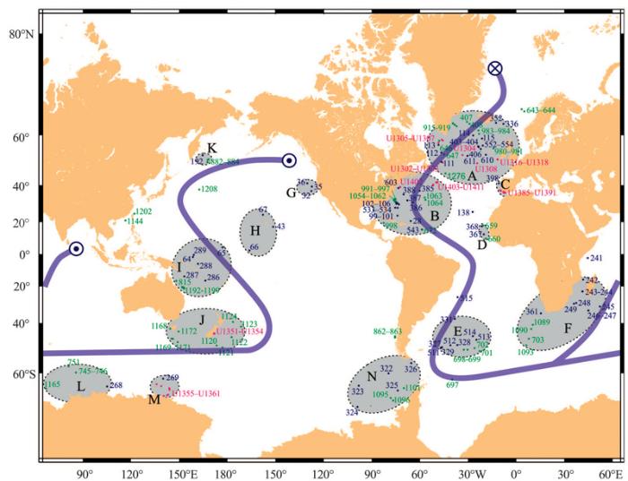
国际大洋钻探计划及其他考察航次近半个世纪以来在全球大洋中进行的地球物理勘探和钻探取芯,基本探明了等积体在全球大洋中的分布情况,发现等积体在全球大洋中的分布受到深水洋流系统,特别是深水西部边界流(Deep Western Boundary Currents, DWBC)和环南极洋流(Antarctic Circumpolar Current,ACC)的控制[8]。全球主要的深层水团包括发源于北大西洋高纬区的北大西洋深层水(North Atlantic Deep Water, NADW)和发源于南极附近的南极底层水(Antarctic Bottom Water,AABW)。NADW形成后沿大西洋西侧从美国东海岸外海区经马尾藻海向南大西洋运移,在南大西洋穿过南美洲东侧巴西阿根廷岸外海区,最终在南大洋汇入环南极深层水(Circumpolar Deep Water,CDW)。AABW 发源于南极附近罗斯海和威德尔海,一支沿大西洋向北运移,其水深处于NADW之下;另一支汇入CDW,并在非洲南端折而向北进入印度洋,并在印度次大陆以南上翻;CDW的另一支在澳大利亚以东折而向北进入太平洋,沿着太平洋西侧向北运移,最终在北美洲西海岸外海区上翻。由于等积体主要是由等深流所携带的沉积物沉降形成的,因此全球等积体的空间分布与大洋深层水的运移路径具有非常好的对应关系。研究发现,等积体在大西洋中的主要分布地点包括:北大西洋海道(图1中的A区)、赤道大西洋马尾藻海(图1中的B区)、伊比利亚半岛岸外加的斯湾(图1中的C区)、西非塞内加尔岸外(图1中的D区)、南大西洋巴西阿根廷岸外(图1中的E区)及非洲南端岸外(图1中的F区)等海区。其在太平洋中的主要分布区域包括:加利福尼亚岸外(图1中的G区)、夏威夷周边海区(图1中的H区)、珊瑚海及所罗门群岛岸外的太平洋开阔海区(图1中的I区)、塔斯曼海及新西兰岸外的太平洋开阔海区(图1中的J区)、堪察加半岛岸外海区(图1中的K区)及南海等海区。此外,南极附近各海区,如威尔克斯地(图1中的区L)、维多利亚地(图1中的M区)及南极半岛岸外各海区(图1中的N区)也是等积体分布比较集中的区域。以上各海区大多均位于全球大洋深层水的运移路径上(图1),显示大洋深层环流是等积体空间分布的首要控制因素。
对于特定海区的等积体而言,其空间分布、形态规模、沉积特征等更多受到其形成地点的环境条件,如深层流的强度方向、局地地形地貌、沉积物供给及构造运动等的影响[8](表1)。在一些水深较浅的等积体分布区域,其沉积和分布还可能受到晚第四纪海平面变化的影响[9]。深水洋流的强度会对沉积物的沉降速率和粒度大小发生巨大影响,在流速极大的地区造成沉积间断甚至原先沉积的等积体顶部的剥蚀。IODP342航次在加拿大岸外纽芬兰盆地(Newfoundland Basin)等积体上钻取的U1403~U1411站整个新近纪地层几乎全部缺失,而古近纪沉积物则保存良好[10]。研究发现,造成这一沉积特征变化的主要因素是底层洋流强度的变化[10]。由于墨西哥湾流的增强,北大西洋深层水在渐新世发生过一次明显的增强[11,12]。受到局地地形和渐新世后流速极高的深层环流的双重影响,NADW携带的沉积物在纽芬兰盆地无法沉降下来,造成该海区等积体新近纪以来沉积地层缺失。类似的事件还发生在美国佛罗里达—南卡罗来纳岸外的布雷克隆起(Blake Plateau)。始新世前布雷克隆起等积体上的ODP1049~1052站沉积速率高达6 cm/ka,但始新世末期后沉积缺失[13],推测与大西洋深水洋流在始新世末增强导致该海区沉积物无法沉降有关[14]。
图1 国际大洋钻探计划(DSDP,ODP及IODP)在全球等积体上进行的钻探站位及全球等积体的空间分布(据参考文献[
深蓝色点显示DSDP站位,深绿色点显示ODP站位,洋红色点显示IODP站位;字母(A~N)标示的灰色阴影区显示等积体在全球大洋中的主要分布区域;半透明箭头显示全球深层水的主要运移路径,其中末端叉形点显示表层水下沉的位置,而圆点则显示深层水上翻的位置
Fig.1 The sites of DSDP, ODP and IODP on the contourite drifts and the spatial distribution of contourite drifts in the world ocean (modified after reference[7])
Blue, red and magenta dots represent DSDP, ODP and IODP sites, respectively. The grey shadowed areas marked with A to N show the main distribution locations of contourites.The translucent blue curve shows the trajectory of deep water movement in the global ocean. The cross end of the trajectory represents the location where downwelling of shallow water forms the NADW, while the dot ends represent the locations where the deep water bodies upwell
等积体形成环境的水深和局地地形地貌特征同样会对其分布和沉积特征发生影响。在广泛调查了大西洋等积体的规模、形态及分布等之后,Faugères等[8]发现北大西洋和南大西洋沉积的等积体规模和形态特征具有很大的不同,北大西洋沉积的等积体主要为巨型大陆边缘延长型等积体(marginal elongated drifts),而南大西洋等积体的主要类型则为席状等积体(sheeted contourites)或与水道相关的等积体(channel-related drifts)。因此,他们提出,等积体形成的局地地貌特征及其与深层环流的相互作用是控制等积体形态和分布的主要因素。后续研究进一步指出,造成南北大西洋等积体规模和形态特征不同的原因,可能是北大西洋的等积体多分布在大陆坡附近,而南大西洋的等积体则更多地沉积在深海平原[15,16]。等积体规模和形态特征在南北大西洋之间的区别,说明等积体的形成与其所在环境的水深和地形地貌特征有很大关系,而将二者联系起来的物理过程仍然是深层环流:由于水深和局地地形地貌会对深海海流的强度和路径等物理海洋学特征产生直接影响,因此可影响其沉积产物——等积体的沉积和分布。
表1 等积体在全球大洋中空间分布的主要影响因素
Table 1 The main control factors of the distribution of contourite drifts in the world ocean
| 全球 分布 | 区域 分布 | 等积体 形态 | 等积体 规模 | |
|---|---|---|---|---|
| 全球大洋环流 | √ | |||
| 区域深层环流 | √ | √ | √ | |
| 地形地貌 | √ | √ | √ | |
| 水深 | √ | √ | ||
| 沉积物供应 | √ | √ | √ | |
| 构造运动 | √ | √ | √ | |
| 海平面变化 | √ |
沉积物供应是影响等积体分布和沉积特征的重要因素。边缘海发育的等积体由于沉积物供应充足往往具有比开阔大洋等积体高得多的沉积速率。地震剖面显示,在南海北部从中国台湾西南直至西沙海槽附近,沿着约2 000 m等深线发育着大量的等积体[17,18]。邵磊等[19]研究发现,南海北部等积体的主要物质来源为中国台湾河流输入南海的沉积物,这些沉积物进入南海后由南海北部深层环流携带搬运至南海内部,并沿等深线沉积下来形成一系列等积体[17]。由于中国台湾岛的持续隆升,ODP184航次在南海东北部东沙东南等积体上钻取的1144站,在过去1 Ma以来的平均沉积速率高达49 cm/ka,而全新世以来的沉积速率更是高达97 cm/ka[20]。相比边缘海发育的等积体而言,开放大洋中发育的等积体由于沉积物供给不足,其沉积速率一般不超过10 cm/ka,在深海平原甚至不超过1 cm/ka。
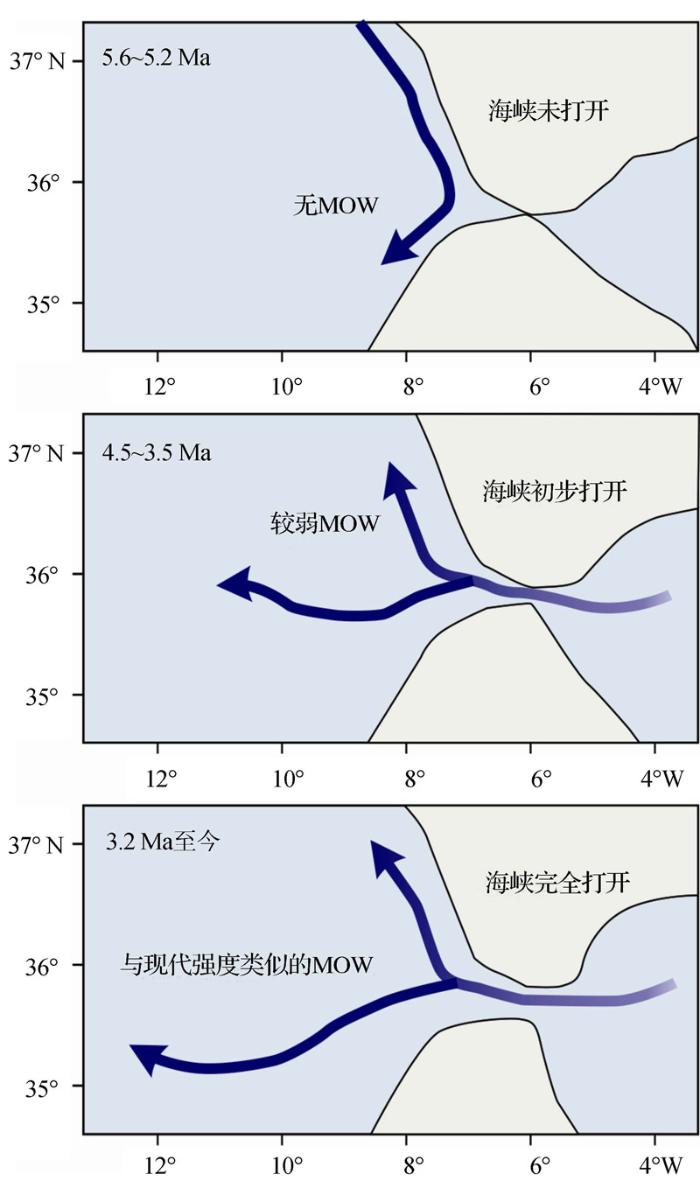
构造运动对于等积体的形成和分布也非常重要[6]。在较长的地质尺度上,海底地形地貌的形成、关键深水海道的开启和关闭以及陆源沉积物的供应等都直接或间接与构造运动有关,而这些因素均会对深层环流的强度和等积物的沉积发生影响。前述南海东北部1144站极高的沉积速率也和中国台湾岛快速构造隆升造成的沉积物剥蚀直接相关[19]。伊比利亚半岛岸外加的斯湾发育的等积物沉积体系是全球目前研究程度最高的等积体之一。2012年进行的IODP339航次以及之前在该海区进行的其他考察航次的研究结果显示,该海区等积体的发育主要受地中海溢出流(Mediterranean Outflow Water,MOW)控制,而MOW的长期演化和加的斯湾等积物沉积体系的发育均主要受控于构造活动[21,22]。研究发现,在5.2 Ma之前直布罗陀海峡尚未打开,因此MOW不发育;随着构造活动的持续进行,直布罗陀海峡逐渐加宽加深,在4.5~3.5 Ma MOW开始发育,但强度较弱;直到3.2 Ma之后,直布罗陀海峡完全打开,与现代条件类似的MOW才正式形成[22,23](图2)。对应地,加的斯湾的等积体在3.2 Ma前为初始发育期(Initial drift stage),主要发育泥质的席状等积体,并周期性地发育浊流沉积物。由于第四纪冰期的活动,加的斯湾等积体的发育在3.2Ma之后又以上新世—更新世为分界线进一步细分为转换发育期(Transitional drift stage, 3.2~2.0 Ma)和增长发育期(Growth drift stage, 2 Ma至今)[21]。转换发育期MOW逐渐加强,加的斯湾沉积物从早期的等积物—浊积物互层逐渐发展为以等积物为主的沉积模式;而增长发育期对应强盛的MOW活动,加的斯湾沉积活动主要以等积体形成为主,且沉积速率明显增加[21]。此外,一些规模较小的构造活动也可对等积体的发育产生影响,如中晚第四纪加的斯湾北部Doñana盆地2次规模较小的构造运动(0.7~0.9 Ma和0.3~0.6 Ma)造成MOW流速在该海盆的局部增大,导致U1389站2次沉积间断的发生[21]。
图2 构造活动控制的地中海溢出流(MOW)自早上新世以来的变化(据参考文献[
Fig.2 The changes of Mediterranean Outflow Water since the Pliocene under the control of tectonic activities (modified after reference[23])
综上可知,等积体在全球大洋中的空间分布格局主要受大洋深层环流,尤其是深水西部边界流和环南极深水洋流运移路径的控制,而其在特定海区的分布和沉积特征则受到局地深层海流强度、地形地貌、沉积物输入及构造运动等多种因素的影响。其中,深层海流的强度是控制等积体沉积和分布的首要因素,其他因素除沉积物输入外都通过影响深层海流强度间接地对等积体发生影响。
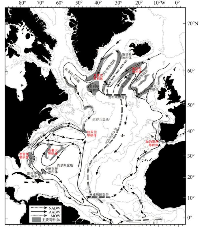
等积体是大洋深层环流的直接沉积产物,因此能够记录全球大洋深层环流的地质演变。而大洋深层环流是全球温盐循环的重要组成部分,其变化受到一系列气候过程,如全球冰盖大小、海气耦合作用、大气二氧化碳浓度、厄尔尼诺—南方涛动(ENSO)等海洋及气候过程的影响。全球大洋中的等积体因而记录了非常丰富的古海洋和古环境演变信息,这些信息几乎涵盖地球表层各个圈层从构造尺度到千年、百年尺度的变化[3,24]。要在一篇论文中综述等积体记录的所有古环境信息,显然是不切实际的。因此,本文集中讨论等积体所记录的全球深层洋流的变化,以大西洋深水西部边界流及地中海溢出流的演变为例(图3),探讨等积体在记录全球深层环流变化方面的贡献。
图3 北大西洋深层环流及主要的等积体分布(据参考文献[
本文涉及的等积体为红色字体
Fig.3 The contourite drifts and the related deep water masses in North Atlantic(modified after reference[15])
Those mentioned in the present study are shown in red texts
通过研究纽芬兰盆地IODP342航次所获取的地震剖面数据和沉积岩芯(U1403~U1411站)岩性数据,Boyle等[25]重建了大西洋DWBC自新生代以来的演变。该研究发现,现代模式的NADW开始形成的时间为早—中始新世界线(约47 Ma),这一时间与早始新世气候适宜期(Early Eocene Climatic Optimum)后开始的全球变冷趋势一致,显示全球气候变化对大西洋深层环流的控制作用[26]。NADW的形成导致纽芬兰盆地等积体的陆源碎屑堆积速率增加至少1个数量级[25]。从中始新世起至晚渐新世期间(47~25 Ma),全球气候经历了一个大幅变冷的过程,NADW的强度和分布深度均持续增加,造成这一时期北美东海岸4 500 m水深以下广泛的地层剥蚀[25]。伴随着晚渐新世气候变暖(Late Oligocene Warming)的发生[27],NADW的强度减弱、分布深度变浅,等积体开始在北大西洋3 500~4 500 m古水深范围内大规模堆积。这一变暖趋势在中—晚中新世界线(约11 Ma)结束[27],伴随着新一轮全球变冷趋势的开始,NADW强度增强,等积体遭受剥蚀的情况重新在大西洋某些海区出现[28]。晚上新世(约3 Ma)北半球冰盖的发育,造成NADW出现明显的冰期/间冰期变化,在等积体沉积特征上则表现为深海/半深海沉积交互出现,并周期性地含有冰筏碎屑,这标志着“现代”大西洋深层环流模式的确立[25]。
重建大西洋深层环流在第四纪冰期—间冰期旋回中的变化,对于理解全球温盐循环对北半球冰盖的响应具有重要意义。利用IODP303航次在格陵兰岛以南艾里克脊(Eirik Ridge)钻取的U1305站(水深3 460 m)和U1306站(水深2 272 m)沉积物,Hillaire-Marcel等[29]和Channell等[30]的2项研究成功地重建了大西洋DWBC在第四纪冰期旋回中的变化。研究发现,U1306站陆源沉积物输入在冰期时上升、而在间冰期下降[30],而U1305站陆源沉积物输入则在冰期时下降、间冰期上升[29]。研究发现,2个站的陆源沉积物均由NADW从上游携带而来,因此其沉积模式的变化反映的是NADW深度的变化[30]。由于U1306站水深较浅而U1305站水深较深,2个站位陆源沉积输入的变化说明NADW在间冰期较活跃且活动深度较大,携带的沉积物主要沉积在U1305站所在水深,而冰期时NADW强度较弱且活动深度较浅,其携带的沉积物更多沉积在U1306站所在较浅的水深范围内[30]。大西洋DWBC在第四纪冰期时强度较弱、分布深度较浅,而在间冰期强度较高、分布深度较大;这一模式与新生代全球变冷趋势中DWBC在变冷过程中强度高深度大、而变暖过程中强度弱深度浅的模式恰好相反,说明北半球冰盖的发育对NADW的形成和活动产生了巨大的影响。
大西洋等积体同时也记录了DWBC在亚冰期乃至千年尺度上的变化。通过对IODP303航次在格陵兰岛附近加达尔等积体(Gardar Drift)上钻取的U1304站沉积物进行分析,Hodell等[31]重建了大西洋DWBC在氧同位素5e期的变化。该研究发现,由于大量融冰水在氧同位素5e期早期(128~124.5 ka)流向北欧海(Nordic Seas),大西洋DWBC并未随间冰期的到来而立刻增强;只有到约124 ka之后DWBC才恢复到间冰期典型的强度大且通风好的状态[31],说明DWBC的变化对冰期—间冰期旋回的响应存在一定的滞后性。另一项对ODP172航次在百慕大隆起(Bermuda Rise)上钻取的1063站沉积物进行的研究发现,NADW只有在接近冰盛期时的Heinrich事件(如H1,H2及H11)时期才出现明显减弱,在末次冰期的其他时间段基本保持稳定,在并非冰盛期的Heinrich事件及Dansgaard-Oeschger事件时期仅略有减弱或增强[32]。这说明,大西洋深层环流对千年尺度气候变化事件的响应存在一定的阈值,只有在冰盛期附近发生的快速气候变化事件才能引发DWBC的明显变化。
与大西洋DWBC的演变不同,MOW在新生代长时间尺度的演变主要受构造活动的影响[22]。对IODP339航次在加的斯湾北部法罗等积体(Faro Drift)上U1387站晚中新世—早上新世沉积物的分析发现,在直布罗陀海峡刚刚打开时(5.3~5.2 Ma),加的斯湾就开始受到MOW的影响,且MOW在季风的影响下呈现出明显的岁差周期变化[33]。在5.2~5.0 Ma,加的斯湾更多地受到大西洋深层水的影响,虽然此事件的原因尚不明了,但至少说明在直布罗陀海峡刚打开的时期,MOW还不太稳定[33]。MOW在上新世早期的变化,显示了构造活动与季风气候的共同影响。
对同样位于法罗等积体上的U1386站沉积物的分析结果显示,晚第四纪约570 ka以来MOW的变化可分为3个阶段:570~475 ka,MOW对U1386站的影响持续较强;475~130 ka,MOW的影响持续较弱且基本不受冰期—间冰期旋回影响;130 ka以来,MOW对U1386站的影响在间冰期较强,而在冰期时较弱甚至消失[34]。研究认为,MOW的演化模式主要与其水团来源发生变化有关:MOW在475~130 ka处于较弱的阶段,其主要来源为东地中海中层水;而在其他2个阶段其主要水团来源为西地中海深层水[34]。同时,与上新世早期类似,MOW在晚第四纪的变化也呈现出明显的岁差周期变化[34,35,36]。研究发现,非洲季风是MOW在晚第四纪岁差周期上变化的主要驱动因素,在北半球夏季辐射量最大值(非洲季风最强)时,地中海深层水中止形成并发育腐泥层,此时MOW强度最弱[35],加的斯湾底层水通风较差但富含营养物质[36]。
与大西洋DWBC类似,MOW的变化也显示出明显的千年尺度变化。对U1387站和U1389站沉积物高分辨率研究结果显示,MOW的变化对Dansgaard-Oeschger事件具有良好的响应,在格陵兰间冰阶(Greenland Interstadials,即D-O事件)MOW较弱,而在格陵兰冰阶(Greenland Stadials)MOW较强[37]。但是,MOW对Heinrich事件的响应比较复杂:在多数Heinrich事件的中期,MOW的分布深度明显加深,其上层分支减弱甚至消失,反映低温低盐的大西洋水团侵入对地中海温盐循环的影响[37]。与此同时,MOW的千年尺度变化还受到全球海平面变化的影响。研究发现,在海平面快速上升或下降的阶段,MOW强度变化的幅度明显增加,说明海平面快速变化时期MOW的变化幅度也比较大[37]。
综上所述,MOW在中新世以来长时间尺度上的演变主要受构造活动控制,而其中晚第四纪以来的变化则受到深层水团来源和冰期旋回的控制。非洲季风控制的地中海深层水形成在岁差周期上变化,也会对MOW造成巨大影响。MOW在氧同位素5期以来千年尺度上的变化则主要受到北半球高纬区气候变化,如D-O事件及北半球冰盖大小引起的全球海平面变化等影响。这显示出MOW的变化受到构造、气候及深层水团来源等多种因素的影响,控制机制非常复杂。相对而言,大西洋DWBC的变化则主要受气候变化的控制,控制机制相对简单:其在始新世以来长时间尺度上的变化主要受新生代全球变冷趋势的控制,而在第四纪冰期旋回和晚第四纪千年尺度上的变化则主要受控于北半球冰盖所引起的气候变化。
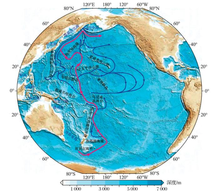
物理海洋学对现代太平洋环流系统的研究结果显示,太平洋具有非常复杂的深层环流系统[38]和活跃的DWBC [39,40](图4)。全球大洋钻探计划沿太平洋DWBC运移路径在所罗门群岛周边、塔斯曼海、新西兰岸外及堪察加半岛岸外等太平洋海区也发现了大量的等积体。但是,目前太平洋深层环流的地质演变及等积体在太平洋中的分布和沉积特征的研究程度远远低于大西洋。同时,由于西太平洋地区受到全球季风系统的强烈影响,因此西太平洋所发育的等积体可能记录了全球季风地质演变的重要气候信息。目前,古气候学界已逐渐认识到:主要由低纬气候变化驱动的全球季风系统可能是极地冰盖驱动之外另一个重要的全球气候变化决定机制,但目前对全球古季风系统演化历史的了解程度远低于北半球高纬区驱动的气候变化[41]。鉴于等积体在记录深层水变化和古季风演化等古气候信息方面具有得天独厚的优势,太平洋尤其是西太平洋海区的等积体,一定会是科学大洋钻探计划未来重点钻探和研究的对象。对所获岩芯样品的后续研究,也将极大地促进太平洋深层水演化、全球古季风系统演化及全球气候低纬驱动机制的研究。
图4 现代太平洋深层环流示意图(据参考文献[
蓝色线条显示深层环流路径,洋红色线条强调太平洋DWBC的主要路径[
Fig.4 The deepwater circulation in the present-day Pacific Ocean (modified after reference[38])
Blue arrows show the paths of deepwater circulation, with emphasized Pacific DWBC shown in magenta arrows[
The authors have declared that no competing interests exist.
| [1] |
Deep sea current evidence from abyssal sediments [J].
Traction velocities necessary for the transport of deep-sea sediment particles probably range from 4–60 cm/sec, velocities similar to those found through dynamic computations of geostrophic currents and observed by recent deep-sea direct current measurements.
|
| [2] |
Shaping of the continental rise by deep geostrophic contour currents [J].
Geostrophic contour-following bottom currents involved in the deep thermohaline circulation of the world ocean appear to be the principal agents which control the shape of the continental rise and other sediment bodies.
|
| [3] |
Contourites and associated sediments controlled by deep-water circulation processes: State-of-the-art and future considerations [J].
61Bottom current-controlled features are ubiquitous in marine basins.61Updated, comprehensive review of the topic “contourites” and associated sediments61History, significance, occurrence, oceanography, geometry, sediments, perspectives61As much objective as possible, with our own synthesis and conclusions61Text equipped with 26 colour figures, 1 table and an exhaustive reference list
|
| [4] |
Abyssal and contour currents [M]∥Rebesco M, Camerlenghi A, eds. |
| [5] |
Bottom currents, contourites and deep-sea sediment drifts: Current state-of-the-art [M]∥Stow D, Pudsey C J, Howe J A, |
| [6] |
Contourite drifts: Nature, evolution and controls [M]∥Rebesco M, Camerlenghi A, eds. |
| [7] |
Contourites [M]∥Selley R C, Cocks L, Plimer I R, eds. Encyclopedia of Geology, Volume 4. |
| [8] |
Contourite drift types and their distribution in the North and South Atlantic Ocean basins [J].
In the North Atlantic, strong bottom circulation, an open basin system and high sediment supply have led to the construction of large elongate contourite drifts, which have striking relief (200–1000 m) above the surrounding sea-floor and are composed of muddy contourites, rich in calcareous pelagic material. In the South Atlantic, strong bottom-currents are often trapped in gyre-like circulation patterns around topographically closed basins or are accelerated through deep, narrow, connecting passages. The resulting deposits are mainly extensive contourite sheets, covered by fields of large sediment waves, and channel-related drifts, including “contourite fans” constructed at the downstream exit of deep passages.
|
| [9] |
The pianosa contourite depositional system (Northern Tyrrhenian Sea): Drift morphology and Plio-Quaternary stratigraphic evolution [J].
The Pianosa Contourite Depositional System (CDS) is located in the Corsica Trough (Northern Tyrrhenian Sea), a confined basin dominated by mass transport and contour currents in the eastern flank and by turbidity currents in the western flank. The morphologic and stratigraphic characterisation of the Pianosa CDS is based on multibeam bathymetry, seismic reflection data (multi-channel high resolution mini GI gun, single-channel sparker and CHIRP), sediment cores and ADCP data. The Pianosa CDS is located at shallow to intermediate water depths (170 to 85002m water depth) and is formed under the influence of the Levantine Intermediate Water (LIW). It is 12002km long, has a maximum width of 1002km and is composed of different types of muddy sediment drifts: plastered drift, separated mounded drift, sigmoid drift and multicrested drift. The reduced tectonic activity in the Corsica Trough since the early Pliocene permits to recover a sedimentary record of the contourite depositional system that is only influenced by climate fluctuations. Contourites started to develop in the Middle–Late Pliocene, but their growth was enhanced since the Middle Pleistocene Transition (0.7–0.902Ma). Although the general circulation of the LIW, flowing northwards in the Corsica Trough, remained active all along the history of the system, contourite drift formation changed, controlled by sediment influx and bottom current velocity. During periods of sea level fall, fast bottom currents often eroded the drift crest in the middle and upper slope. At that time the proximity of the coast to the shelf edge favoured the formation of bioclastic sand deposits winnowed by bottom currents. Higher sediment accumulation of mud in the drifts occurred during periods of fast bottom currents and high sediment availability (i.e. high activity of turbidity currents), coincident with periods of sea level low-stands. Condensed sections were formed during sea level high-stands, when bottom currents were more sluggish and the turbidite system was disconnected, resulting in a lower sediment influx.
|
| [10] |
Paleogene Newfoundland Sediment Drifts. Integrated Ocean Drilling Program Preliminary Reports, Volume 342[R] . |
| [11] |
Early Oligocene initiation of North Atlantic Deep Water formation [J].
Abstract Dating the onset of deep-water flow between the Arctic and North Atlantic oceans is critical for modelling climate change in the Northern Hemisphere and for explaining changes in global ocean circulation throughout the Cenozoic era (from about 65 million years ago to the present). In the early Cenozoic era, exchange between these two ocean basins was inhibited by the Greenland-Scotland ridge, but a gateway through the Faeroe-Shetland basin has been hypothesized. Previous estimates of the date marking the onset of deep-water circulation through this basin-on the basis of circumstantial evidence from neighbouring basins-have been contradictory, ranging from about 35 to 15 million years ago. Here we describe the newly discovered Southeast Faeroes drift, which extends for 120 km parallel to the basin axis. The onset of deposition in this drift has been dated to the early Oligocene epoch ( approximately 35 million years ago) from a petroleum exploration borehole. We show that the drift was deposited under a southerly flow regime, and conclude that the initiation of deep-water circulation from the Norwegian Sea into the North Atlantic Ocean took place much earlier than is currently assumed in most numerical models of ancient ocean circulation.
|
| [12] |
Evolution of Atlantic thermohaline circulation: Early Oligocene onset of deep-water production in the North Atlantic [J]. |
| [13] |
Cretaceous-palaeogene Ocean and climate change in the Subtropical North Atlantic [M]∥Kroon D, Norris R D, Klaus A, eds. |
| [14] |
Mid-eocene deep water, the late palaeocene thermal maximum and continental slope mass wasting during the cretaceous-palaeogene impact [M]∥Kroon D, Norris R D, Klaus A, eds. |
| [15] |
Abyssal plain contourites [M] |
| [16] |
Continental slope contourites [M]∥Rebesco M, Camerlenghi A, eds. |
| [17] |
Deep water bottom current deposition in the northern South China Sea [J].南海北部深水底流沉积作用 [J].
南海北部深水陆坡区存在极为活跃的深水底流沉积作用.通过浅地层 地震剖面解释发现,该地区由于深水底流的搬运作用,在水深1000~2700 m左右的陆坡地带形成NE-SW向分布的迁移水道.在水道东侧断续形成由东北向西南方向推进的高沉积速率堆积体,堆积体内部叠加层呈NE-SW向前积堆积 特征,由牵引流沉积而成.发育在东沙群岛东南侧的高沉积速率堆积体就是其中之一,其12 ka以来沉积速率高达97 cm/ka,是南海目前所知沉积速率最高的海区.地震剖面显示,该深水底流极有可能是由进入南海的西太平洋环流演变而成,挟带南海北部来源的沉积物沿大陆 坡由东北向西南方向搬运沉积,最终消失在中央海盆中.由于深水底流作用的存在,造成南海北部深海区复杂的搬运沉积格局.
|
| [18] |
Deep-water sedimentary systems and their relationship with bottom currents at the intersection of Xisha Trough and Northwest Sub-Basin, South China Sea [J].
Based upon 2D reflection seismic data and numerical modelling, this study confirms the presence of a complex deep-water sedimentary system on the present-day seafloor at the intersection of the Xisha Trough and the Northwest Sub-Basin (South China Sea) and investigates their relationship with bottom currents. The deep-water sedimentary system consists of submarine canyons, slides and slumps, wave-like successions, mounded drifts and two groups of marginal depressions (those with erosional features and those appearing as morphological sediment sinks). Three-dimensional process-based modelling is applied to investigate sediment dynamics induced by a combined effect of tidal currents and a quasi-steady geostrophic current (South China Sea Deep Water Circulation). Simulation results show that the South China Sea Deep Water Circulation at the southeastern flank of the seamount plateau could reach velocities of 15聽cm/s during flood tides, enabling erosion and transport processes. In contrast, the rest of the plateau area is favoured for deposition, since current velocities in this region are persistently lower than 10聽cm/s. The current velocities at the feet of the obstacles (where the morphological depressions are located) are strengthened and are several cm/s higher than that in adjacent flat areas (e.g. where the mounded drifts are located). The flow is constricted and accelerated after being deflected by the obstacles, resulting in contrasting higher sedimentation rates within the mounded sediments and lower rates at the morphological depressions. A comparison between the seismic stratigraphy and the simulated fluid dynamics enables a decoding of the pathway, identifying the current regime as well as unravelling the relationship between depositional processes and the deep-sea water circulation. This study provides new insights and exposes new challenges in understanding the dynamics of deep-sea sedimentation processes in South China Sea.
|
| [19] |
Provenance of a prominent sediment drift on the northern slope of the South China Sea [J].南海陆坡高速堆积体的物质来源 [J]. |
| [20] |
Toward a high-resolution stable isotope stratigraphy of the Last 1.1 m.y.: Site 1144, South China Sea [C]∥ |
| [21] |
Evolution of the Gulf of Cadiz margin and southwest Portugal contourite depositional system: Tectonic, sedimentary and paleoceanographic implications from IODP expedition 339 [J].
We identify significant changes in sedimentation style and dominant sedimentary processes, coupled with widespread depositional hiatuses along the SIM within the Cadiz, Sanlucar, Do09ana, Algarve and Alentejo basins. Following the 4.502Ma cessation of a previous phase of tectonic activity related to the Miocene–Pliocene boundary, tectonics continued to influence margin development, downslope sediment transport and CDS evolution. Sedimentary features indicate tectonic pulses of about 0.8–0.902Ma duration with a pronounced overprint of ~022–2.502Ma cycles. These more protracted cycles relate to the westward rollback of subducted lithosphere at the convergent Africa-Eurasia plate boundary as its previous NW–SE compressional regime shifted to a WNW–ESE direction. Two major compressional events affecting to the Neogene basins at 3.2–302Ma and 2–2.302Ma help constrain the three main stages of CDS evolution. The stages include: 1) the initial-drift stage (5.33–3.202Ma) with a weak MOW, 2) a transitional-drift stage (3.2–202Ma) and 3) a growth-drift stage (202Ma-present time) with enhanced MOW circulation into the Atlantic and associated contourite development due to greater bottom-current velocity. Two minor Pleistocene discontinuities at 0.7–0.902Ma and 0.3–0.602Ma record the effects of renewed tectonic activity on basin evolution, appearing most prominently in the Do09ana basin. Several discontinuities bounding major and minor units appear on seismic profiles. Quaternary records offer the clearest example of this, with major units of about 0.8–0.902Ma and sub-units of 0.4–0.502Ma. Sedimentation is controlled by a combination of tectonics, sediment supply, sea-level and climate. This research identifies time scales of tectonic controls on deep-marine sedimentation, specifically over periods of 2.5–>020.402Ma. Shorter-term climatic (orbital) mechanisms control sedimentation at time scales of ≤020.402Ma. The role of bottom water circulation and associated processes in shaping the seafloor and controlling the sedimentary stacking pattern on continental margins has to be seriously reconsidered in future multidisciplinary studies. This is not only because of the common occurrence of sandy contourite deposits in deep water setting and their economic interest for hydrocarbon exploration, but principally because they archive the heartbeat of the interior Earth and therefore have important sedimentary and paleoceanographic implications.
|
| [22] |
. Onset of Mediterranean outflow into the North Atlantic [J]. |
| [23] |
A salty start to modern ocean circulation: Water flow out of the Mediterranean is linked to large-scale ocean circulation patterns [J].
Water flow out of the Mediterranean is linked to large-scale ocean circulation patterns [Also see Research Article by Hernández-Molina et al.] Author: Gabriel Filippelli
|
| [24] |
Paleocenographic significance of contourite drifts [M] |
| [25] |
Cenozoic North Atlantic deep circulation history recorded in contourite drifts, offshore Newfoundland, Canada [J].
In the North Atlantic Ocean, contour-following deep currents have created regional erosional unconformities and deposited contourite drifts that exceed 202km in thickness and extend for 10002s of km. The stratigraphic records in the drifts have been used to reconstruct variations in North Atlantic deep-water circulation throughout the Cenozoic; however, uncertainties remain about certain aspects of the timing, intensity, depth distribution, and regional impact of these currents. Here, we use an integrated dataset of seismic-reflection profiles and IODP core data (lithology, biostratigraphy, and magnetostratigraphy) to document sedimentation history and the development of current effects in the Cretaceous to present sedimentary record on the J-Anomaly Ridge and Southeast Newfoundland Ridge, offshore Newfoundland, Canada. The Newfoundland ridges are in a key location, lying between well-studied areas in the northern and western North Atlantic and under the path of both the modern Deep Western Boundary Current and the Gulf Stream. Late Cretaceous through Early Eocene sedimentation on the ridges was dominated by biogenic pelagic sedimentation, but at ~024702Ma, near the Early-Middle Eocene boundary, well developed contourite drifts began to accrete in paleo-water depths of ~024000–450002m, accompanied by an order-of-magnitude increase in terrigenous sediment mass accumulation rates. From this time forward, drift deposition, interrupted by brief episodes of erosion, continued unabated. This timing for the onset of persistent deep currents is coincident with reorganization of Atlantic circulation inferred from a change from biosiliceous to non-biosiliceous sedimentation in the western North Atlantic (Horizon A C ) and with the current-eroded Intra-Eocene Unconformity (IEU) in the northern North Atlantic. A change in sedimentation style occurred within the Middle Eocene to upper Oligocene drift sequence, and it likely was related to a shift to deeper, more intense currents that eroded the widespread Horizon A U along the margin of eastern North America about Early Oligocene time. Beginning in the Late Oligocene (~022502Ma) a thick drift exhibiting seismically laminated mudwaves was deposited in a distinct belt at ~023500–450002m paleodepth on the Southeast Newfoundland Ridge. This development correlates with widespread Late Oligocene through Miocene-Pliocene drift accumulation throughout the North Atlantic. The most recent phase of drift deposition, since Late Pliocene time (~02302Ma), occurred after a shift to the ‘modern’ circulation system of deeper, swifter currents, and it includes mixed pelagic-hemipelagic sediments and ice-rafted debris that reflect glacial-interglacial influences on sedimentation.
|
| [26] |
Onset of North Atlantic deep water production coincident with inception of the Cenozoic global cooling trend [J].
Here we show that the onset of deep water overflow from the Norwegian-Greenland Sea into the North Atlantic, interpreted to represent the onset of a modern-style North Atlantic Deep Water mass, commenced close to the early to middle Eocene boundary. This finding is based on the identification of a large, elongate contourite sediment drift, the “Judd Falls Drift,” in the Faeroe-Shetland Basin, through detailed mapping of high-resolution two-dimensional and three-dimensional seismic data. This sediment drift covers an area of 659000 km2 in one of the critical present-day deep water gateways into the North Atlantic Ocean. Interpretation of the body as a contourite drift is based on standard seismic-stratigraphic diagnostic criteria including tridirectional onlap, lensoid sediment geometry, upslope progradational configurations of stacked onlap units, and an erosional base cut in a deepwater setting. The internal reflection configuration indicates that the drift was deposited under a southwest-flowing current regime, which we propose represents the onset of North Atlantic Deep Water production, with continual deep water flow until at least the latest Eocene (ca. 35 million years ago [Ma]). Onset of drift deposition is dated by several key boreholes as occurring at ca. 50–49 Ma, across the early to middle Eocene boundary, and is coincident with independent geochemical evidence for major changes in the configuration of deep-sea circulation patterns, global biological production, and the onset of Cenozoic climatic cooling. These temporal concurrences suggest a strong link between the initiation of North Atlantic Deep Water production and Cenozoic global climate evolution.
|
| [27] |
Trends, rhythms, and aberrations in global climate 65 Ma to present [J].
Since 65 million years ago (Ma), Earth's climate has undergone a significant and complex evolution, the finer details of which are now coming to light through investigations of deep-sea sediment cores. This evolution includes gradual trends of warming and cooling driven by tectonic processes on time scales of 105to 107years, rhythmic or periodic cycles driven by orbital processes with 104- to 106-year cyclicity, and rare rapid aberrant shifts and extreme climate transients with durations of 103to 105years. Here, recent progress in defining the evolution of global climate over the Cenozoic Era is reviewed. We focus primarily on the periodic and anomalous components of variability over the early portion of this era, as constrained by the latest generation of deep-sea isotope records. We also consider how this improved perspective has led to the recognition of previously unforeseen mechanisms for altering climate.
|
| [28] |
Geophysical evidence for widespread Cenozoic bottom current activity from the continental margin of Nova Scotia, Canada [J].
61Contourite drifts contribute significantly to the Cenozoic section below the continental margin of Nova Scotia, Canada.613D seismic reflection data allow determination of past bottom-current direction.61A northeast to southwest flowing bottom current persisted along the Nova Scotia margin since the Late Eocene.61The results generally agree with observations from the rest of the North Atlantic.
|
| [29] |
Foraminifer isotope study of the Pleistocene Labrador Sea, northwest North Atlantic (IODP Sites 1302/03 and 1305), with emphasis on paleoceanographical differences between its “inner” and “outer” basins [J]. |
| [30] |
. Age through tandem correlation of Quaternary relative paleointensity (RPI) and oxygen isotope data at IODP Site U1306 (Eirik drift, SW Greenland) [J].
Planktic oxygen isotope (δ 18 O) and relative paleointensity (RPI) data are used in tandem to generate an age model for the last 1 Myr from Integrated Ocean Drilling Program (IODP) Site U1306 drilled on the crest of the Eirik Drift (SW Greenland) in 2272m water depth. For the 1–1.5Ma interval, the age model is based on RPI alone due to insufficient foraminifera for isotope analyses. Utilizing RPI and δ 18 O in tandem allows recognition of low-δ 18 O “events” prior to glacial Terminations I, III, IV, V, VII, VIII, IX and X, that are independently supported by radiocarbon dates through the last deglaciation, and are attributed to local or regional surface-water effects. At Site U1306, Quaternary sedimentation rates (mean 6515cm/ka) are elevated during peak glacials and glacial onsets, and are reduced during interglacials, in contrast to the pattern at Site U1305 in 3460m water depth at the distal toe of the drift, 191km SW of Site U1306. The contrasting sedimentation-rate pattern appears to hold for the entire 651.5 Myr record. The slackening and/or shoaling (due to lowered salinity) of the Deep Western Boundary Current (DWBC) during glacial intervals coincided with greater sediment supply to Site U1306 whereas the deepening, and possibly increased vigor, of the DWBC during interglacial intervals boosted sediment supply to Site U1305.
|
| [31] |
Surface and deep-water hydrography on Gardar Drift (Iceland Basin) during the last interglacial period [J].
Changes in surface and deep-water hydrography were inferred from variations in stable isotopes and sortable silt mean grain size, respectively, on the southern Gardar Drift in the subpolar North Atlantic. The bathymetric δ 13C gradient during the penultimate glaciation was similar to the last glaciation with high- δ 13C Glacial North Atlantic Intermediate water above 65 2000 m, and low- δ 13C water derived from the Southern Ocean below. During Termination II, low- δ 13C water was present throughout the water column with minimum values at intermediate depths (65 1500–2000 m) and below 3000 m. This pattern continued well into the early part of the Last Interglacial (LIG) period. Sortable silt mean size at 3275 m suggests that deep-water circulation on Gardar Drift was relatively weak during the earliest part of the LIG (128 to 124.5 ka) when planktonic δ 18O was at a minimum, reflecting warming and/or reduced salinity. We suggest that low- δ 13C water and slow current speed on Gardar Drift during the early part of the LIG was related to increased melt water fluxes to the Nordic Seas during peak boreal summer insolation, which decreased the flux and/or density of overflow to the North Atlantic. The resumption of the typical interglacial pattern of strong, well-ventilated Iceland Scotland Overflow Water was delayed until 65 124 ka. These changes may have affected Atlantic Meridional Overturning Circulation.
|
| [32] |
Strong and deep Atlantic meridional overturning circulation during the last glacial cycle [J].
Abstract Extreme, abrupt Northern Hemisphere climate oscillations during the last glacial cycle (140,000 years ago to present) were modulated by changes in ocean circulation and atmospheric forcing. However, the variability of the Atlantic meridional overturning circulation (AMOC), which has a role in controlling heat transport from low to high latitudes and in ocean CO2 storage, is still poorly constrained beyond the Last Glacial Maximum. Here we show that a deep and vigorous overturning circulation mode has persisted for most of the last glacial cycle, dominating ocean circulation in the Atlantic, whereas a shallower glacial mode with southern-sourced waters filling the deep western North Atlantic prevailed during glacial maxima. Our results are based on a reconstruction of both the strength and the direction of the AMOC during the last glacial cycle from a highly resolved marine sedimentary record in the deep western North Atlantic. Parallel measurements of two independent chemical water tracers (the isotope ratios of (231)Pa/(230)Th and (143)Nd/(144)Nd), which are not directly affected by changes in the global cycle, reveal consistent responses of the AMOC during the last two glacial terminations. Any significant deviations from this configuration, resulting in slowdowns of the AMOC, were restricted to centennial-scale excursions during catastrophic iceberg discharges of the Heinrich stadials. Severe and multicentennial weakening of North Atlantic Deep Water formation occurred only during Heinrich stadials close to glacial maxima with increased ice coverage, probably as a result of increased fresh-water input. In contrast, the AMOC was relatively insensitive to submillennial meltwater pulses during warmer climate states, and an active AMOC prevailed during Dansgaard-Oeschger interstadials (Greenland warm periods).
|
| [33] |
Benthic foraminifera-based reconstruction of the first Mediterranean-Atlantic exchange in the early Pliocene Gulf of Cadiz [J].
Upper Miocene to lower Pliocene sediment cores from Integrated Ocean Drilling Program (IODP) Hole U1387C (IODP Expedition 339) have been studied. The main goal of this study is to reconstruct initial Mediterranean-Atlantic water exchange after the opening of the Gibraltar Strait in the early Pliocene. Benthic foraminiferal assemblages are the focus of the palaeoceanographic analyses of this work. A distinct faunal turnover indicates a considerable change of the depositional environment at the Miocene/Pliocene boundary. Foraminiferal composition suggests high rates of organic carbon flux and poorly oxygenated sea-floor environment for the basal, late Messinian interval. In contrast, earliest Pliocene assemblages point to periodic advection of warm, better ventilated and likely Mediterranean-sourced waters to the studied site. Parallel periodic changes in Siphonina tubulosa , Globocassidulina subglobosa , and Planulina ariminensis and previously established sedimentological and geochemical records (Zr/Al,18 O) suggest a rather sluggish Mediterranean Outflow between ~聽5.3 and 5.2聽Ma. Benthic foraminifera, along with sedimentological and geochemical data thus provide the earliest indications of Mediterranean-Atlantic water exchange following the opening of the Gibraltar Strait. Sandy layers become frequent towards the top of the interval. These sediments are rich in shelf foraminifera, reflecting episodes of turbidite deposition possibly caused by tectonic adjustments related to the opening of the Gibraltar Strait. The allochthonous assemblages frequently contain Cibicides lobatulus and C . refulgens , species that have been considered indicators of Mediterranean Outflow Water (MOW) in previous studies. Our results warrant for caution when applying these species as MOW proxy in the fossil record if there is evidence for downslope transport.
|
| [34] |
Mediterranean Outflow Water dynamics during the past ~570 kyr: Regional and global implications [J].
The Gulf of Cadiz constitutes a prime area to study teleconnections between the North Atlantic Ocean and climate change in the Mediterranean realm. In particular, the highly saline Mediterranean Outflow Water (MOW) is an important modulator of the North Atlantic salt budget on intermediate water levels. However, our understanding of its paleoceanographic evolution is poorly constrained due to the lack of high-resolution proxy records that predate the last glacial cycle. Here we present the first continuous and high-resolution ( 1 kyr) benthic 未O and 未C as well as grain size records from Integrated Ocean Drilling Program Site U1386 representing the last 570 kyr. We find three distinct phases of MOW variability throughout the Late to Middle Pleistocene at Site U1386 associated with prominent shifts in its composition and flow strength. We attribute this long-term variability to changes in water mass sourcing of the MOW. Superimposed on the long-term change in water mass sourcing is the occurrence of distinct and precession paced 未O enrichment events, which contrast the pattern of global ice volume change as inferred from the global mean 未O signal (i.e., LR04) but mimics that of the adjacent Mediterranean Sea. We attribute these enrichment events to a profound temperature reduction and salinity increases of the MOW, aligning with similar changes in the Mediterranean source region. These events might further signify ice volume increases as inferred from significant sea level drops recorded in the Red Sea and/or increased influence of North Atlantic intermediate water masses when MOW influence was absent at Site U1386.
|
| [35] |
Persistent monsoonal forcing of Mediterranean Outflow Water dynamics during the late Pleistocene [J].
The mode and vigor of the global oceanic circulation critically depend on the salinity of (sub)surface water masses advected to the loci of deep-water formation. Within the Atlantic meridional overturning circulation (AMOC), an important supplier of high-salinity waters is the Mediterranean Outflow Water (MOW), discharging into the North Atlantic via the Strait of Gibraltar. Despite its importance for the North Atlantic salinity budget, the long-term dynamics of MOW production have remained poorly understood. Here we present high-resolution records of bottom-current velocity from three drill sites within the Gulf of C谩diz that document a persistent low-latitude forcing of MOW flow speed over the past ~150 k.y. We demonstrate that the African monsoon is the predominant driver of orbital-scale MOW variability via its influence on the freshwater budget of the eastern Mediterranean Sea. Consequently, MOW formation fluctuates in concert with orbital precession overprinted by centennial-scale oscillations of high-latitude origin. We further document that Northern Hemisphere summer insolation minima stimulate maximal injection of MOW-derived salt into the North Atlantic, likely strengthening the intermediate AMOC branch. The direct coupling of MOW dynamics to low-latitude climate forcing represents a hitherto neglected process for propagating (sub)tropical climate signals into the high northern latitudes.
|
| [36] |
Fluctuations of Mediterranean Outflow Water circulation in the Gulf of Cadiz during MIS 5 to 7: Evidence from benthic foraminiferal assemblage and stable isotope records [J].
We studied variations in benthic foraminiferal assemblages and13 C for the last 225聽kyr at IODP site U1387 which is currently bathed by upper core of the Mediterranean Outflow Water (MOW). The MOW paleocirculation and sea-floor environment (oxygen level, trophic condition, bottom current strength) have been inferred from faunal composition; species diversity, abundances of selected index species/groups, microhabitat preferences combined with13 C record of the epifaunal Cibicidoides pachyderma . The faunal and isotope records indicate relatively better ventilation at sea-floor and low trophic condition during MIS 1, 5 and 7 possibly due to increased influence of upper MOW in the Gulf of Cadiz. Our multi-proxy record reflects significant and rapid changes during cold (stadial) and warm (interstadial) phases within the interglacials MIS 5 and 7 and at Termination II. The faunal and isotope records reveal strong MOW flow and better ventilated, oligotrophic bottom-water conditions during stadials MIS 5b, 5d, 7b and 7d. The study further demonstrates weakened MOW intensity associated with poor ventilation and increased trophic level at sea-floor during interstadials MIS 5a, 5e, 7a and 7c. MOW flow was relatively sluggish at Termination II, followed by its strengthening at the end of MIS 5e. The chronology of these events suggests that periods of weakened MOW correlate with sapropel layers of the Mediterranean Sea, implying strong coupling between glacial-搃nterglacial climate and MOW circulation in the Gulf of Cadiz.
|
| [37] |
Deciphering bottom current velocity and paleoclimate signals from contourite deposits in the Gulf of Cadiz during the last 140 kyr: An inorganic geochemical approach [J].
in the Gulf of C璋ヾiz (GC) preserve a unique archive of Mediterranean Outflow Water (MOW) variability over the past 5.3 Ma. In our study, we investigate the potential of geochemical data obtained by XRF scanning to decipher bottom current processes and paleoclimatic evolution at two different sites drilled during IODP Expedition 339 through contourites in the northern GC: Site U1387, which is bathed by the upper MOW core, and Site U1389, located more proximal to the Strait of Gibraltar. The lack of major downslope transport during the Pleistocene makes both locations ideally suited for our study. The results indicate that the Zr/Al ratio, representing the relative enrichment of heavy minerals (zircon) over less dense alumnosilicates under fast bottom current flow, is the most useful indicator for a semiquantitative assessment of current velocity. Although most elements are biased by current-related processes, the bromine (Br) record, representing organic content, preserves the most pristine climate signal rather independent of grain-size changes. Hence, Br can be used for chronostratigraphy and site-to-site correlation in addition to stable isotope stratigraphy. Based on these findings, we reconstructed MOW variability for Marine Isotope Stages (MIS) 1-5 using the Zr/Al ratio from Site U1387. The results reveal abrupt, millennial-scale variations of MOW strength during Greenland Stadials (GS) and Interstadials (GI) with strong MOW during GS and glacial Terminations and a complex behavior during Heinrich Stadials. Millennial-scale variability persisting during periods of poorly expressed GS/GI cyclicities implies a strong internal oscillation of the Mediterranean/North Atlantic climate system.
|
| [38] |
Descriptive Physical Oceanography—An Introduction [M]. |
| [39] |
Deep-water circulation at low latitudes in the western North Pacific [J].
Full-depth conductivity-temperature-depth-oxygen profiler (CTDO 2 ) data at low latitudes in the western North Pacific in winter 1999 were analyzed with water-mass analysis and geostrophic calculations. The result shows that the deep circulation carrying the Lower Circumpolar Water (LCPW) bifurcates into eastern and western branch currents after entering the Central Pacific Basin. LCPW colder than 0.98°C is carried by the eastern branch current, while warmer LCPW is carried mainly by the western branch current. The eastern branch current flows northward in the Central Pacific Basin, supplying water above 0.94°C through narrow gaps into an isolated deep valley in the Melanesian Basin, and then passes the Mid-Pacific Seamounts between 162°10′E and 170°10′E at 18°20′N, not only through the Wake Island Passage but also through the western passages. Except near bottom, dissolved oxygen of LCPW decreases greatly in the northern Central Pacific Basin, probably by mixing with the North Pacific Deep Water (NPDW). The western branch current flows northwestward over the lower Solomon Rise in the Melanesian Basin and proceeds westward between 10°40′N and 12°20′N at 150°E in the East Mariana Basin with volume transport of 4.102Sv (102Sv=10 6 02m 3 02s 611 ). The current turns north, west of 150°E, and bifurcates around 14°N, south of the Magellan Seamounts, where dissolved oxygen decreases sharply by mixing with NPDW. Half of the current turns east, crosses 150°E at 14–15°N, and proceeds northward primarily between 152°E and 156°E at 18°20′N toward the Northwest Pacific Basin (2.102Sv). The other half flows northward west of 150°E and passes 18°20′N just east of the Mariana Trench (2.202Sv). It is reversed by a block of topography, proceeds southward along the Mariana Trench, then detours around the south end of the trench, and proceeds eastward along the Caroline Seamounts to the Solomon Rise, partly flowing into the West Mariana and East Caroline Basins. A deep western boundary current at 2000–300002m depth above LCPW (10.002Sv) closes to the coast than the deep circulation. The major part of it (8.502Sv) turns cyclonic around the upper Solomon Rise from the Melanesian Basin and proceeds along the southern boundary of the East Caroline Basin. Nearly half of it proceeds northward in the western East Caroline Basin, joins the current from the east, then passes the northern channel, and mostly enters the West Caroline Basin (4.602Sv), while another half enters this basin from the southern side (>3.802Sv). The remaining western boundary current (1.502Sv) flows over the middle and lower Solomon Rise, proceeds westward, then is divided by the Caroline Seamounts into southern (0.902Sv) and northern (0.502Sv) branches. The southern branch current joins that from the south in the East Caroline Basin, as noted above. The northern branch current proceeds along the Caroline Seamounts and enters the West Mariana Basin.
|
| [40] |
Characteristics of deep currents along trenches in the northwest Pacific [J].
In the deep sea area of the Japan Trench, located about 150 km east from northern Honshu, one observes southward flow on the landward slope and the northward flow on the oceanward slope. In 1994 and 1995, moorings were deployed on the Japan Trench landward slope around 40°N. One mooring was deployed for 275 days at about 5800 m, and another mooring was deployed for 20 days at 4200 m depth. Results showed the following: (1)A deep western boundary current flows south-southwest on the landward slope of the Japan Trench with mean speed of 3–7 cm/sec and maximum speed of 15–20 cm/s. (2) Current changes depend mainly on the M2 tide. (3) Previous measurements, as well as inferences from observed benthic fauna, imply oppositely directed flow along the oceanward slope of the Trench, forming a trench countercurrent.
|
| [41] |
The global monsoon across time scales: Mechanisms and outstanding issues [J].
The present paper addresses driving mechanisms of global monsoon (GM) variability and outstanding issues in GM science. This is the second synthesis of the PAGES GM Working Group following the first synthesis “The Global Monsoon across Time Scales: coherent variability of regional monsoons” published in 2014 (Climate of the Past, 10, 2007–2052). Here we introduce the GM as a planetary scale circulation system and give a brief accounting of why it exhibits regional structure. The primary driver of the GM is solar insolation, and the specific features in the underlying surface, such as land-sea distribution, topography, and oceanic circulations, are mainly responsible for the differences among regional monsoon systems. We then analyze the monsoon formation mechanisms, together with the major processes that drive monsoon variations at various timescales, including external forcings and internal feedbacks. On long time scales external forcings often induce variability on a global scale, whereas short-term variability in regional monsoon systems is usually caused by internal feedbacks within the climate system. Finally, a number of debatable issues are discussed, with an emphasis on time scales beyond the instrumental record. These include the dual nature of the monsoon as wind and rain, the meaning of oxygen isotope in hydrological cycle, in particular of speleothem δ 18 O, the role of ice-sheet in monsoon variations, etc. In general, the GM as a system comprises a hierarchy of regional and local monsoons with different level of similarity, but all show coherent variability driven by a common solar forcing. The GM concept, therefore, is by no means to replace or depreciate research on the regional monsoons, but helps to dissect the mechanism and controlling factors of the monsoon variability at various temporal-spatial scales.
|

/
| 〈 |
|
〉 |
