

Spatial Correlation Characteristics Between Gradient Development and Land Subsidence in Typical Mountainous Towns
Received date: 2024-04-08
Revised date: 2024-06-09
Online published: 2024-07-29
Supported by
the National Natural Science Foundation of China(42271214);Key Project of Natural Science Foundation of Gansu Province(21JR7RA281);Western Light Talent Training Program of the Chinese Academy of Sciences(2020XBZG-XBQNXZ-A)
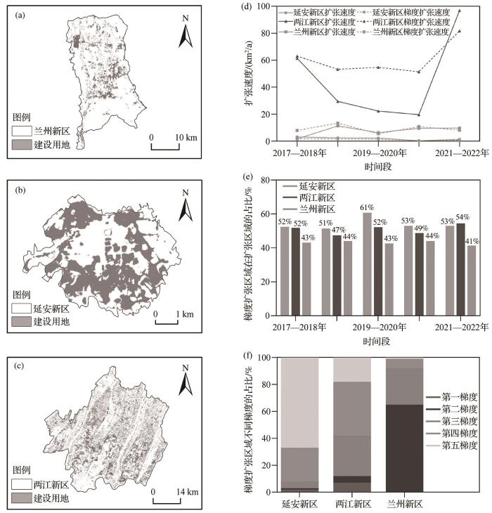
The development of mountainous towns is limited by the terrain and landforms, resulting in an urban expansion model dominated by new city construction. The geographical spatial manifestation of this model is that the construction of new cities is far from the main urban area and urban construction land gradually expands toward higher slopes (i.e., gradient expansion of construction land). Although gradient expansion solves the problem of land resource scarcity in mountainous towns, it also increases the risk of geological disasters, such as land subsidence. Exploring the law of gradient expansion and identifying disaster risks are paramount. This study selected three new cities with severe gradient expansion as typical case areas and used DEM to obtain the gradient expansion areas of the new areas from 2017 to 2022. Based on Sentinel-1A SAR data from 2016 to 2020, SBAS InSAR technology was used to obtain surface deformation information in order to reveal the spatial correlation between gradient expansion and land subsidence in new areas.
Zhenghong LI , Liang ZHOU , Hong GAO , Wenda WANG , Wei WEI . Spatial Correlation Characteristics Between Gradient Development and Land Subsidence in Typical Mountainous Towns[J]. Advances in Earth Science, 2024 , 39(7) : 752 -765 . DOI: 10.11867/j.issn.1001-8166.2024.053
| 1 | DILLE A, DEWITTE O, HANDWERGER A L, et al. Acceleration of a large deep-seated tropical landslide due to urbanization feedbacks[J]. Nature Geoscience, 2022, 15: 1 048-1 055. |
| 2 | GAO L, BRYAN B A. Finding pathways to national-scale land-sector sustainability[J]. Nature, 2017, 544: 217-222. |
| 3 | QIAO W Y, HUANG X J. Assessment the urbanization sustainability and its driving factors in Chinese urban agglomerations: an urban land expansion—urban population dynamics perspective[J]. Journal of Cleaner Production, 2024, 449. DOI: 10.1016/j.jclepro.2024.141562 . |
| 4 | LI R P, XU Q R, YU J, et al. Multiscale assessment of the spatiotemporal coupling relationship between urbanization and ecosystem service value along an urban-rural gradient: a case study of the Yangtze River Delta urban agglomeration, China[J]. Ecological Indicators, 2024, 160. DOI: 10.1016/j.ecolind.2024.111864 . |
| 5 | DAME J, SCHMIDT S, MüLLER J, et al. Urbanisation and socio-ecological challenges in high mountain towns: insights from Leh (Ladakh), India[J]. Landscape and Urban Planning, 2019, 189: 189-199. |
| 6 | MEI Le, MA Xing, LIAN Xinlong, et al. Influence of land use change on the susceptibility of geological disasters in the process of urbanization[J]. Journal of Natural Disasters, 2023, 32(5): 186-196. |
| 6 | 梅乐, 马星, 连鑫龙, 等. 城市化过程中土地利用变化对地质灾害易发性影响的研究[J]. 自然灾害学报, 2023, 32(5): 186-196. |
| 7 | JIANG Yuefeng, ZHOU Liang, CHEN Zhijie. Slope-climbing characteristics of typical valley-type urban construction land and its ecological quality influence[J]. Mountain Research, 2022, 40(4): 570-580. |
| 7 | 姜跃锋, 周亮, 陈志杰. 典型河谷型城市建设用地的爬坡特征及其生态质量影响[J]. 山地学报, 2022, 40(4): 570-580. |
| 8 | ZHANG Z X, LI Y. Coupling coordination and spatiotemporal dynamic evolution between urbanization and geological hazards-a case study from China[J]. The Science of the Total Environment, 2020, 728. DOI: 10.1016/j.scitotenv.2020.138825 . |
| 9 | WANG Penglong, WANG Bao, XU Bingxin, et al. Progress and prospect of sustainable development goals in underdeveloped mountainous areas[J]. Advances in Earth Science, 2022, 37(9): 937-948. |
| 9 | 王鹏龙, 王宝, 徐冰鑫, 等. 欠发达山区可持续发展目标研究进展与展望[J]. 地球科学进展, 2022, 37(9): 937-948. |
| 10 | DING Yu, ZHANG Lei, MA Xinlin. Temporal and spatial evolution of coupling coordination of mountainous urbanization and its resource and environment carrying capacity[J]. Research of Environmental Sciences, 2022, 35(2): 592-600. |
| 10 | 丁宇, 张雷, 马昕琳. 山地城镇化与资源环境承载力耦合协调发展的时空演变[J]. 环境科学研究, 2022, 35(2): 592-600. |
| 11 | KUANG B, LU X H, HAN J, et al. How urbanization influence urban land consumption intensity: evidence from China[J]. Habitat International, 2020, 100. DOI: 10.1016/j.habitatint.2019.102103 . |
| 12 | LI G Y, LIU J H, SHAO W W. Urban flood risk assessment under rapid urbanization in Zhengzhou City, China[J]. Regional Sustainability, 2023, 4(3): 332-348. |
| 13 | LI G R, LEI Y L, YAO H J, et al. The influence of land urbanization on landslides: an empirical estimation based on Chinese provincial panel data[J]. The Science of the Total Environment, 2017, 595: 681-690. |
| 14 | BATUBARA B, KOOY M, ZWARTEVEEN M. Politicising land subsidence in Jakarta: how land subsidence is the outcome of uneven sociospatial and socionatural processes of capitalist urbanization[J]. Geoforum, 2023, 139. DOI: 10.1016/j.geoforum.2023.103689 . |
| 15 | van VERSEVELD H C W, van DONGEREN A R, PLANT N G, et al. Modelling multi-hazard hurricane damages on an urbanized coast with a Bayesian Network approach[J]. Coastal Engineering, 2015, 103: 1-14. |
| 16 | WANG Z L, OU L, CHEN M. Evolution characteristics, drivers and trends of rural residential land in mountainous economic circle: a case study of Chengdu-Chongqing area, China[J]. Ecological Indicators, 2023, 154. DOI: 10.1016/j.ecolind.2023.110585 . |
| 17 | ZHOU Liang, DANG Xuewei, ZHOU Chenghu, et al. Evolution characteristics of slope spectrum and slope-climbing effects of built-up land in China[J]. Acta Geographica Sinica, 2021, 76(7): 1 747-1 762. |
| 17 | 周亮, 党雪薇, 周成虎, 等. 中国建设用地的坡谱演化规律与爬坡影响[J]. 地理学报, 2021, 76(7): 1 747-1 762. |
| 18 | ZHANG X, ZENG X Y, LUO H, et al. The relationship between geological disasters with land use change, meteorological and hydrological factors: a case study of Neijiang City in Sichuan Province[J]. Ecological Indicators, 2023, 154. DOI:10.1016/j.ecolind.2023.110840 . |
| 19 | PENG Qiuzhi, TANG Lin, CHEN Jie,et al .Study on the evolution of construction land slope spectrum in Shenzhen during 2000-2015[J]. Journal of Natural Resources,2018,33(12): 2 200-2 212. |
| 19 | 彭秋志,唐铃,陈杰,等 . 2000—2015年深圳市建设用地坡谱演变研究[J].自然资源学报,2018,33(12): 2 200-2 212. |
| 20 | CHEN S, WANG X Y, LIN Q. Spatial pattern characteristics and influencing factors of mountainous rural settlements in metropolitan fringe area: a case study of Pingnan County, Fujian Province[J]. Heliyon, 2024, 10(4). DOI: 10.1016/j.heliyon.2024.e26606 . |
| 21 | LI P Y, QIAN H, WU J H. Environment: accelerate research on land creation[J]. Nature, 2014, 510: 29-31. |
| 22 | ZHANG F Y, SHU H P, YAN B B, et al. Characteristic analysis and potential hazard assessment of reclaimed mountainous areas in Lanzhou, China[J]. CATENA, 2023, 221. DOI:10.1016/j.catena.2022.106771 . |
| 23 | YANG J X, LI J J, XU F, et al. Urban development wave: understanding physical spatial processes of urban expansion from density gradient of new urban land[J]. Computers, Environment and Urban Systems, 2022, 97. DOI:10.1016/j.compenvurbsys.2022.101867 . |
| 24 | ZHOU L, DANG X W, MU H W, et al. Cities are going uphill: slope gradient analysis of urban expansion and its driving factors in China[J]. The Science of the Total Environment, 2021, 775. DOI: 10.1016/j.scitotenv.2021.145836 . |
| 25 | MURAKAMI A, MEDRIAL Z A, TAKEUCHI K, et al. Trends in urbanization and patterns of land use in the Asian mega Cities Jakarta, Bangkok, and Metro Manila[J]. Landscape and Urban Planning, 2005, 70(3/4): 251-259. |
| 26 | SHI K F, YU B L, MA J J, et al. Impacts of slope climbing of urban expansion on global sustainable development[J]. Innovation (Cambridge (Mass)), 2023, 4(6). DOI: 10.1016/j.xinn.2023.100529 . |
| 27 | DU Y N, FENG D C, WU G. InSAR-based rapid damage assessment of urban building portfolios following the 2023 Turkey earthquake[J]. International Journal of Disaster Risk Reduction, 2024, 103. DOI: 10.1016/j.ijdrr.2024.104317 . |
| 28 | ZOU F, CHE E Z, LONG M Q. Quantitative assessment of geological hazard risk with different hazard indexes in mountainous areas[J]. Journal of Cleaner Production, 2023, 413. DOI: 10.1016/j.jclepro.2023.137467 . |
| 29 | ZHU Jianjun, LI Zhiwei, HU Jun. Research progress and methods of InSAR for deformation monitoring[J]. Acta Geodaetica et Cartographica Sinica, 2017, 46(10): 1 717-1 733. |
| 29 | 朱建军, 李志伟, 胡俊. InSAR变形监测方法与研究进展[J]. 测绘学报, 2017, 46(10): 1 717-1 733. |
| 30 | PONZIANI F, CIUFFI P, BAYER B, et al. Regional-scale InSAR investigation and landslide early warning thresholds in Umbria, Italy[J]. Engineering Geology, 2023, 327. DOI: 10.1016/j.enggeo.2023.107352 . |
| 31 | HAN Bingquan, LIU Zhenjiang, CHEN Bo, et al. Coseismic deformation and slip distribution of the 2022 Luding Mw6.6 earthquake revealed by InSAR observations[J]. Geomatics and Information Science of Wuhan University, 2023, 48(1): 36-46. |
| 31 | 韩炳权, 刘振江, 陈博, 等. 2022年泸定Mw6.6地震InSAR同震形变与滑动分布[J]. 武汉大学学报(信息科学版), 2023, 48(1): 36-46. |
| 32 | LI Zhenhong, HAN Bingquan, LIU Zhenjiang, et al. Source parameters and slip distributions of the 2016 and 2022 Menyuan, Qinghai earthquakes constrained by InSAR observations[J]. Geomatics and Information Science of Wuhan University, 2022, 47(6): 887-897. |
| 32 | 李振洪, 韩炳权, 刘振江, 等. InSAR数据约束下2016年和2022年青海门源地震震源参数及其滑动分布[J]. 武汉大学学报(信息科学版), 2022, 47(6): 887-897. |
| 33 | NING Rongrong, WANG De, TIAN Xinpeng, et al. Analysis of ground settlement in the Yellow River Delta and projection of seawater inundation[J]. Advances in Earth Science, 2023, 38(3): 296-308. |
| 33 | 宁荣荣, 王德, 田信鹏, 等. 黄河三角洲的地面沉降分析以及海水淹没预估[J]. 地球科学进展, 2023, 38(3): 296-308. |
| 34 | GONG Xiang, XU Qiang, PU Chuanhao, et al. InSAR time series monitoring and analysis of land deformation after mountain excavation and city construction in Lanzhou New Area[J]. Geomatics and Information Science of Wuhan University, 2024, 49(2): 236-245. |
| 34 | 龚翔, 许强, 蒲川豪, 等. 兰州新区平山造城竣工后地表形变InSAR时序监测与分析[J]. 武汉大学学报(信息科学版), 2024, 49(2): 236-245. |
| 35 | MENG Ran, JIANG Yanan, LIAO Lu, et al. Monitoring of post-construction ground settlement and analysis of influencing factors in Pingshan city building, Yan’an new district[J/OL]. Progress in Geophysics, 2024:1-15.[2024-04-20]. . |
| 35 | 孟冉,蒋亚楠,廖露,等.延安新区平山造城工后地面沉降监测及影响因素分析[J/OL]. 地球物理学进展,2024:1-15. [2024-04-20]. . |
| 36 | PU Chuanhao, XU Qiang, ZHAO Kuanyao, et al. Land uplift monitoring and analysis in Yan’an new district based on SBAS-InSAR technology[J]. Geomatics and Information Science of Wuhan University, 2021, 46(7): 983-993. |
| 36 | 蒲川豪, 许强, 赵宽耀, 等. 利用小基线集InSAR技术的延安新区地面抬升监测与分析[J]. 武汉大学学报(信息科学版), 2021, 46(7): 983-993. |
| 37 | MO Ying, ZHU Yufeng, JIANG Liming, et al. Land subsidence monitoring of Nanchang area based on Sentinel-1A using time series InSAR technology[J]. Journal of Geodesy and Geodynamics, 2020, 40(3): 270-275. |
| 37 | 莫莹, 朱煜峰, 江利明, 等. 基于Sentinel-1A的南昌市时间序列InSAR地面沉降监测[J]. 大地测量与地球动力学, 2020, 40(3): 270-275. |
| 38 | SHI K F, CUI Y Z, LIU S R, et al. Global urban land expansion tends to be slope climbing: a remotely sensed nighttime light approach[J]. Earth’s Future, 2023, 11(4). DOI: 10.1029/2022EF003384 . |
| 39 | ZHANG Min, YANG Liya, HU Zhuowei,et al .Spatiotemporal differentiation and influencing mechanism of urban expansion in the Yangtze River Economic Belt,China[J]. Acta Geographica Sinica,2024,79(2):439-461. |
| 39 | 张敏,杨励雅,胡卓玮,等.长江经济带城市扩张的时空分异特征及影响机制[J].地理学报,2024,79(2):439-461. |
| 40 | XIA Shengjie, CHEN Huiru, ZHANG Junwei,et al .Spatial autocorrelation analysis of ecological land dynamic evolution and thermal environment:a case study of Shanxi central urban agglomeration[J]. China Environmental Science,2024,44(2):1 032-1 040. |
| 40 | 夏圣洁,陈慧儒,张钧韦,等.生态用地动态演变与热环境的空间自相关分析——以山西中部城市群为例[J].中国环境科学,2024,44(2):1 032-1 040. |
| 41 | XU Yong, ZHAO Shen, FAN Jie. Urban planning construction land standard and its revision of climate and topography in China[J]. Acta Geographica Sinica, 2020, 75(1): 194-208. |
| 41 | 徐勇, 赵燊, 樊杰. 中国城市规划建设用地标准及气候和地形地貌修订[J]. 地理学报, 2020, 75(1): 194-208. |
| 42 | WU D, ZHENG L, WANG Y, et al. Characteristics of urban expansion in megacities and its impact on water-related ecosystem services: a comparative study of Chengdu and Wuhan, China[J]. Ecological Indicators, 2024, 158. DOI: 10.1016/j.ecolind.2023.111322 . |
| 43 | XU Qiang, PU Chuanhao, ZHAO Kuanyao, et al. Time series InSAR monitoring and analysis of spatiotemporal evolution characteristics of land subsidence in Yan’an New District[J]. Geomatics and Information Science of Wuhan University, 2021, 46(7): 957-969. |
| 43 | 许强, 蒲川豪, 赵宽耀, 等. 延安新区地面沉降时空演化特征时序InSAR监测与分析[J]. 武汉大学学报(信息科学版), 2021, 46(7): 957-969. |
| 44 | CHELARIU O E, MINEA I, IA?U C. Geo-hazards assessment and land suitability estimation for spatial planning using multi-criteria analysis[J]. Heliyon, 2023, 9(7). DOI:10.1016/j.heliyon.2023.e18159 . |
| 45 | ZHANG H X, ZENG R Q, ZHANG Y, et al. Subsidence monitoring and influencing factor analysis of mountain excavation and valley infilling on the Chinese Loess Plateau: a case study of Yan’an New District[J]. Engineering Geology, 2022, 297.DOI: 10.1016/j.enggeo.2021.106482 . |
/
| 〈 |
|
〉 |
