

星载被动微波亮温影像轨道间隙填补:进展与展望
收稿日期: 2024-04-22
修回日期: 2024-11-29
网络出版日期: 2025-03-13
基金资助
国家自然科学基金项目(42271387)
Orbital Gap Filling for Satellite Passive Microwave Brightness Temperature Images: Progress and Prospects
Received date: 2024-04-22
Revised date: 2024-11-29
Online published: 2025-03-13
Supported by
the National Natural Science Foundation of China(42271387)
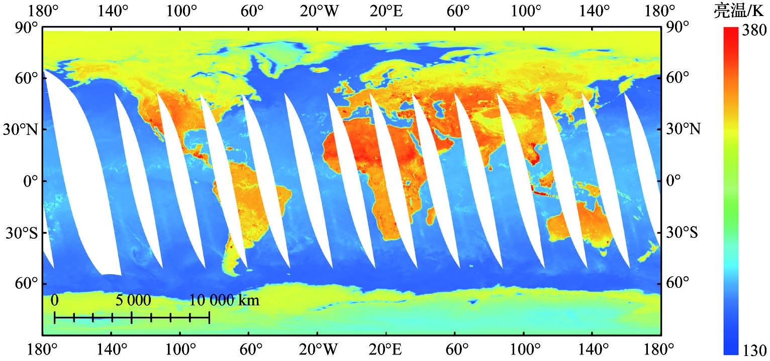
被动微波亮度温度是反演多种地表参量的关键基础数据。极轨卫星搭载的被动微波成像仪获得的被动微波亮温影像在相邻轨道之间存在因轨道间隙导致的观测缺失。填补轨道间隙有利于提高基于亮温生成的次生产品的时空完整性、增强其应用潜力。通过回顾被动微波辐射传输理论、轨道间隙形成原因及其影响,针对基于多源数据填补与基于有效源数据重构这两类遥感数据缺失值填补方法进行了总结,分析了其应用于被动微波亮温影像轨道间隙填补的前景。在梳理被动微波亮温轨道间隙填补的相关研究与存在的问题时,发现目前已有针对星载被动微波亮温轨道间隙填补的研究较少且均使用了多源数据,传感器的差异导致这类方法普适性不高。总结了当前研究所面临的挑战,从使用再分析资料和时间序列建模的角度,探讨了在考虑特殊下垫面情况下,构建具有良好普适性的高精度统一重构方法的未来方向。
王永杰 , 张晓东 , 唐文彬 , 赵少杰 , 马晋 , 孟义真 , 王子卫 , 周纪 . 星载被动微波亮温影像轨道间隙填补:进展与展望[J]. 地球科学进展, 2025 , 40(1) : 99 -110 . DOI: 10.11867/j.issn.1001-8166.2025.003
Passive Microwave Brightness Temperature (PMWBT) is crucial for retrieving various land surface parameters. However, PMWBT images often exhibit many missing observations, particularly in low-latitude areas, owing to the limited coverage of polar-orbit satellites equipped with PMW radiometer imagers. Filling these gaps is essential to enhance the spatiotemporal integrity and application potential of PMW-derived products. To better understand the problem and propose solutions, the PMW radiative transfer theory and the reasons for the observation gaps are comprehensively reviewed. Subsequently, two filling approaches, multi-source data filling and effective data reconstruction, which are commonly used in remote sensing, were introduced and assessed for their suitability in filling PMWBT gaps. Upon reviewing related research and existing issues in filling PMW BT orbital gaps, it was observed that current studies on filling satellite-borne passive microwave brightness temperature orbital gaps are limited, and all use multi-source data with low generalizability because of sensor differences. In conclusion, the current research status and challenges are succinctly summarized. Furthermore, from the perspective of using reanalysis data and time-series modeling, the construction of a high-precision, general reconstruction method under special underlying surface conditions was explored.
| 1 | ZHONG Ruofei, GUO Huadong, WANG Weimin. Overview of soil moisture retrieval from passive microwave remote sensing[J]. Remote Sensing Technology and Application, 2005, 20(1): 49-57. |
| 钟若飞, 郭华东, 王为民. 被动微波遥感反演土壤水分进展研究[J]. 遥感技术与应用, 2005, 20(1): 49-57. | |
| 2 | WIGNERON J P, JACKSON T J, O’NEILL P, et al. Modelling the passive microwave signature from land surfaces: a review of recent results and application to the L-band SMOS & SMAP soil moisture retrieval algorithms[J]. Remote Sensing of Environment, 2017, 192: 238-262. |
| 3 | JIA Yuanyuan, LI Zhaoliang. Progress in land surface temperature retrieval from passive microwave remotely sensed data[J]. Progress in Geography, 2006, 25(3): 96-105. |
| 贾媛媛, 李召良. 被动微波遥感数据反演地表温度研究进展[J]. 地理科学进展, 2006, 25(3): 96-105. | |
| 4 | DUAN S B, HAN X J, HUANG C, et al. Land surface temperature retrieval from passive microwave satellite observations: state-of-the-art and future directions[J]. Remote Sensing, 2020, 12(16). DOI:10.3390/rs12162573 . |
| 5 | ZHANG Miao, WANG Sujuan, QIN Danyu, et al. The inversion and quality validation of FY-3C MWRI sea surface temperature[J]. Journal of Remote Sensing, 2018, 22(5): 713-722. |
| 张淼, 王素娟, 覃丹宇, 等. FY-3C微波成像仪海面温度产品算法及精度检验[J]. 遥感学报, 2018, 22(5): 713-722. | |
| 6 | ALERSKANS E, ZINCK A P, NIELSEN-ENGLYST P, et al. Exploring machine learning techniques to retrieve sea surface temperatures from passive microwave measurements[J]. Remote Sensing of Environment, 2022, 281. DOI:10.1016/j.rse.2022.113220 . |
| 7 | LI Xiaoqing. Review of algorithms for retrieving rainfall from spaceborne passive microwave measurements[J]. Meteorological Science and Technology, 2004, 32(3): 149-154. |
| 李小青. 星载被动微波遥感反演降水算法回顾[J]. 气象科技, 2004, 32(3): 149-154. | |
| 8 | TODD M C, KIDD C, KNIVETON D, et al. A combined satellite infrared and passive microwave technique for estimation of small-scale rainfall[J]. Journal of Atmospheric and Oceanic Technology, 2001, 18(5): 742-755. |
| 9 | LI Xin, CHE Tao. A review on passive microwave remote sensing of snow cover[J]. Journal of Glaciology and Geocryology, 2007, 29(3): 487-496. |
| 李新, 车涛. 积雪被动微波遥感研究进展[J]. 冰川冻土, 2007, 29(3): 487-496. | |
| 10 | TANNIRU S, RAMSANKARAN R. Passive microwave remote sensing of snow depth: techniques, challenges and future directions[J]. Remote Sensing, 2023, 15(4). DOI:10.3390/rs15041052 . |
| 11 | WU P H, YIN Z X, ZENG C, et al. Spatially continuous and high-resolution land surface temperature product generation: a review of reconstruction and spatiotemporal fusion techniques[J]. IEEE Geoscience and Remote Sensing Magazine, 2021, 9(3): 112-137. |
| 12 | ANDRé C, OTTLé C, ROYER A, et al. Land surface temperature retrieval over circumpolar Arctic using SSM/I-SSMIS and MODIS data[J]. Remote Sensing of Environment, 2015, 162: 1-10. |
| 13 | ZHENG D H, WANG X, van der VELDE R, et al. Impact of surface roughness, vegetation opacity and soil permittivity on L-band microwave emission and soil moisture retrieval in the third pole environment[J]. Remote Sensing of Environment, 2018, 209: 633-647. |
| 14 | MONCET J L, LIANG P, GALANTOWICZ J F, et al. Land surface microwave emissivities derived from AMSR-E and MODIS measurements with advanced quality control[J]. Journal of Geophysical Research, 2011, 116(D16). DOI:10.1029/2010JD015429 . |
| 15 | WU Ying, WANG Zhenhui. Advances in the study of land surface emissivity retrieval from passive microwave remote sensing[J]. Remote Sensing for Land & Resources, 2012, 24(4): 1-7. |
| 吴莹, 王振会. 被动微波遥感反演地表发射率研究进展[J]. 国土资源遥感, 2012, 24(4): 1-7. | |
| 16 | CHE Tao, LI Xin. The development and prospect of estimating snow water equivalent using passive microwave remote sensing data[J]. Advances in Earth Science, 2004, 19(2): 204-210. |
| 车涛, 李新. 被动微波遥感估算雪水当量研究进展与展望[J]. 地球科学进展, 2004, 19(2): 204-210. | |
| 17 | ZHANG Tingjun, JIN Rui, GAO Feng. Overview of the satellite remote sensing of frozen ground: passive microwave sensors[J]. Advances in Earth Science, 2009, 24(10): 1 073-1 083. |
| 张廷军, 晋锐, 高峰. 冻土遥感研究进展: 被动微波遥感[J]. 地球科学进展, 2009, 24(10): 1 073-1 083. | |
| 18 | CORDISCO E, PRIGENT C, AIRES F. Snow characterization at a global scale with passive microwave satellite observations[J]. Journal of Geophysical Research: Atmospheres, 2006, 111(D19). DOI:10.1029/2005JD006773 . |
| 19 | ZHENG D H, WANG X, van der VELDE R, et al. L-band microwave emission of soil freeze-thaw process in the third pole environment[J]. IEEE Transactions on Geoscience and Remote Sensing, 2017, 55(9): 5 324-5 338. |
| 20 | WANG Zhenzhan, WANG Wenyu, TONG Xiaolin, et al. Progress in spaceborne passive microwave remote sensing technology and its application[J]. Chinese Journal of Space Science, 2023, 43(6): 986-1 015. |
| 王振占, 王文煜, 佟晓林, 等. 星载被动微波遥感技术及其应用进展[J]. 空间科学学报, 2023, 43(6): 986-1 015. | |
| 21 | SHEN H F, LI X H, CHENG Q, et al. Missing information reconstruction of remote sensing data: a technical review[J]. IEEE Geoscience and Remote Sensing Magazine, 2015, 3(3): 61-85. |
| 22 | DING Lirong, ZHOU Ji, ZHANG Xiaodong, et al. Estimation of all-weather land surface temperature with remote sensing: progress and challenges[J]. National Remote Sensing Bulletin, 2023, 27(7): 1 534-1 553. |
| 丁利荣, 周纪, 张晓东, 等. 全天候地表温度遥感获取进展与挑战[J]. 遥感学报, 2023, 27(7): 1 534-1 553. | |
| 23 | ZHOU Fangcheng, TANG Shihao, HAN Xiuzhen, et al. Research on reconstructing missing remotely sensed land surface temperature data in cloudy sky[J]. Remote Sensing for Land & Resources, 2021, 33(1): 78-85. |
| 周芳成, 唐世浩, 韩秀珍, 等. 云下遥感地表温度重构方法研究[J]. 国土资源遥感, 2021, 33(1): 78-85. | |
| 24 | MO Y P, XU Y M, CHEN H J, et al. A review of reconstructing remotely sensed land surface temperature under cloudy conditions[J]. Remote Sensing, 2021, 13(14). DOI:10.3390/rs13142838 . |
| 25 | HUANG C, DUAN S B, JIANG X G, et al. A physically based algorithm for retrieving land surface temperature under cloudy conditions from AMSR2 passive microwave measurements[J]. International Journal of Remote Sensing, 2019, 40(5/6): 1 828-1 843. |
| 26 | DUAN S B, LI Z L, LENG P. A framework for the retrieval of all-weather land surface temperature at a high spatial resolution from polar-orbiting thermal infrared and passive microwave data[J]. Remote Sensing of Environment, 2017, 195: 107-117. |
| 27 | ZHANG X D, ZHOU J, LIANG S L, et al. A practical reanalysis data and thermal infrared remote sensing data merging (RTM) method for reconstruction of a 1-km all-weather land surface temperature[J]. Remote Sensing of Environment, 2021, 260. DOI:10.1016/j.rse.2021.112437 . |
| 28 | GAO F, MASEK J, SCHWALLER M, et al. On the blending of the Landsat and MODIS surface reflectance: predicting daily Landsat surface reflectance[J]. IEEE Transactions on Geoscience and Remote Sensing, 2006, 44(8): 2 207-2 218. |
| 29 | ROY D P, JU J C, LEWIS P, et al. Multi-temporal MODIS-Landsat data fusion for relative radiometric normalization, gap filling, and prediction of Landsat data[J]. Remote Sensing of Environment, 2008, 112(6): 3 112-3 130. |
| 30 | ZHANG X D, ZHOU J, LIANG S L, et al. Estimation of 1-km all-weather remotely sensed land surface temperature based on reconstructed spatial-seamless satellite passive microwave brightness temperature and thermal infrared data[J]. ISPRS Journal of Photogrammetry and Remote Sensing, 2020, 167: 321-344. |
| 31 | TANG W B, XUE D J, LONG Z Y, et al. Near-real-time estimation of 1-km all-weather land surface temperature by integrating satellite passive microwave and thermal infrared observations[J]. IEEE Geoscience and Remote Sensing Letters, 2021, 19. DOI:10.1109/LGRS.2021.3067908 . |
| 32 | LIAN Y H, DUAN S B, HUANG C, et al. Generation of spatial-seamless AMSR2 land surface temperature in China during 2012-2020 using a deep neural network[J]. IEEE Transactions on Geoscience and Remote Sensing, 2023, 61. DOI: 10.1109/TGRS.2023.3247806 . |
| 33 | XU S, CHENG J, ZHANG Q. A random forest-based data fusion method for obtaining all-weather land surface temperature with high spatial resolution[J]. Remote Sensing, 2021, 13(11). DOI:10.3390/rs13112211 . |
| 34 | GUENTHER B, XIONG X, SALOMONSON V V, et al. On-orbit performance of the Earth Observing System Moderate Resolution Imaging Spectroradiometer: first year of data[J]. Remote Sensing of Environment, 2002, 83(1/2): 16-30. |
| 35 | WANG L L, QU J J, XIONG X X, et al. A new method for retrieving band 6 of aqua MODIS[J]. IEEE Geoscience and Remote Sensing Letters, 2006, 3(2): 267-270. |
| 36 | RAKWATIN P, TAKEUCHI W, YASUOKA Y. Restoration of aqua MODIS band 6 using histogram matching and local least squares fitting[J]. IEEE Transactions on Geoscience and Remote Sensing, 2009, 47(2): 613-627. |
| 37 | YANG Dengke. Influences of different interpolation methods on GPS time series[J]. GNSS World of China, 2019, 44(5): 66-69. |
| 杨登科. 不同插值方法对GPS时间序列的影响分析[J]. 全球定位系统, 2019, 44(5): 66-69. | |
| 38 | CHEN Yanjun, ZHANG Yuhong. Filling algorithm for missing pixels in Landsat-7 SLC-off images using no reference images[J]. Scientia Geographica Sinica, 2021, 41(7): 1 276-1 284. |
| 陈彦军, 张玉红. 无参考图条件下的Landsat-7 SLC-off图像缺失像素填充算法研究[J]. 地理科学, 2021, 41(7): 1 276-1 284. | |
| 39 | JONSSON P, EKLUNDH L. Seasonality extraction by function fitting to time-series of satellite sensor data[J]. IEEE Transactions on Geoscience and Remote Sensing, 2002, 40(8): 1 824-1 832. |
| 40 | BECK P S A, ATZBERGER C, H?GDA K A, et al. Improved monitoring of vegetation dynamics at very high latitudes: a new method using MODIS NDVI[J]. Remote Sensing of Environment, 2006, 100(3): 321-334. |
| 41 | SHAO Y, LUNETTA R S, WHEELER B, et al. An evaluation of time-series smoothing algorithms for land-cover classifications using MODIS-NDVI multi-temporal data[J]. Remote Sensing of Environment, 2016, 174: 258-265. |
| 42 | YANG Y P, LUO J C, HUANG Q T, et al. Weighted double-logistic function fitting method for reconstructing the high-quality sentinel-2 NDVI time series data set[J]. Remote Sensing, 2019, 11(20). DOI:10.3390/rs11202342 . |
| 43 | XIE C J, HUANG C, ZHANG D Q, et al. BiLSTM-I: a deep learning-based long interval gap-filling method for meteorological observation data[J]. International Journal of Environmental Research and Public Health, 2021, 18(19). DOI:10.3390/ijerph181910321 . |
| 44 | LIGUORI A, MARKOVIC R, FRISCH J, et al. A gap-filling method for room temperature data based on autoencoder neural networks[C]// Proceedings of building simulation 2021: 17th conference of IBPSA. KU Leuven, 2021, 17: 2 427-2 434. |
| 45 | GOLYANDINA N, NEKRUTKIN V, ZHIGLJAVSKY A. Analysis of time series structure: SSA and related techniques[M]. New York: Chapman and Hall/CRC, 2001. |
| 46 | KONDRASHOV D, GHIL M. Spatio-temporal filling of missing points in geophysical data sets[J]. Nonlinear Processes in Geophysics, 2006, 13(2): 151-159. |
| 47 | KONDRASHOV D, SHPRITS Y, GHIL M. Gap filling of solar wind data by singular spectrum analysis[J]. Geophysical Research Letters, 2010, 37(15). DOI:10.1029/2010GL044138 . |
| 48 | GHAFARIAN M H R, ROUSTA I, OLAFSSON H, et al. Gap-filling of MODIS time series Land Surface Temperature (LST) products using Singular Spectrum Analysis (SSA)[J]. Atmosphere, 2018, 9(9). DOI:10.3390/atmos9090334 . |
| 49 | OLIVER M A, WEBSTER R. Kriging: a method of interpolation for geographical information systems[J]. International Journal of Geographical Information Systems, 1990, 4(3): 313-332. |
| 50 | ZHANG C, LI W, TRAVIS D. Gaps-fill of SLC-off Landsat ETM+ satellite image using a geostatistical approach[J]. International Journal of Remote Sensing, 2007, 28(22): 5 103-5 122. |
| 51 | CHEN F W, LIU C W. Estimation of the spatial rainfall distribution using Inverse Distance Weighting (IDW) in the middle of Taiwan[J]. Paddy and Water Environment, 2012, 10(3): 209-222. |
| 52 | SHENG Zheng, SHI Hanqing, DING Youzhuan. Missing satellite-based sea surface temperature data reconstructed by DINEOF method[J]. Advances in Marine Science, 2009, 27(2): 243-249. |
| 盛峥, 石汉青, 丁又专. 利用DINEOF方法重构缺测的卫星遥感海温数据[J]. 海洋科学进展, 2009, 27(2): 243-249. | |
| 53 | FAN Zide, GONG Jianya, LIU Bo, et al. A space-time interpolation method of missing data based on spatiotemporal heterogeneity[J]. Acta Geodaetica et Cartographica Sinica, 2016, 45(4): 458-465. |
| 樊子德, 龚健雅, 刘博, 等. 顾及时空异质性的缺失数据时空插值方法[J]. 测绘学报, 2016, 45(4): 458-465. | |
| 54 | YANG J, HU M G. Filling the missing data gaps of daily MODIS AOD using spatiotemporal interpolation[J]. Science of the Total Environment, 2018, 633: 677-683. |
| 55 | POGGIO L, GIMONA A, BROWN I. Spatio-temporal MODIS EVI gap filling under cloud cover: an example in Scotland[J]. ISPRS Journal of Photogrammetry and Remote Sensing, 2012, 72: 56-72. |
| 56 | WANG G J, GARCIA D, LIU Y, et al. A three-dimensional gap filling method for large geophysical datasets: application to global satellite soil moisture observations[J]. Environmental Modelling & Software, 2012, 30: 139-142. |
| 57 | ZHANG Q, YUAN Q Q, LI J, et al. Generating Seamless Global Daily AMSR2 Soil Moisture (SGD-SM) long-term products for the years 2013-2019[J]. Earth System Science Data, 2021, 13(3): 1 385-1 401. |
| 58 | WU P H, SU Y, DUAN S B, et al. A two-step deep learning framework for mapping gapless all-weather land surface temperature using thermal infrared and passive microwave data[J]. Remote Sensing of Environment, 2022, 277. DOI:10.1016/j.rse.2022.113070 . |
| 59 | HUANG X H, LI C, YANG T, et al. Seamless reconstruction of AMSR-E land surface temperature swath gaps for China’s landmass[J]. IEEE Transactions on Geoscience and Remote Sensing, 2023, 61. DOI: 10.1109/TGRS.2023.3335820 . |
| 60 | GERBER F, de JONG R, SCHAEPMAN M E, et al. Predicting missing values in spatio-temporal remote sensing data[J]. IEEE Transactions on Geoscience and Remote Sensing, 2018, 56(5): 2 841-2 853. |
| 61 | ZHANG Q, YUAN Q Q, ZENG C, et al. Missing data reconstruction in remote sensing image with a unified spatial-temporal-spectral deep convolutional neural network[J]. IEEE Transactions on Geoscience and Remote Sensing, 2018, 56(8): 4 274-4 288. |
| 62 | SHAO M W, WANG C, ZUO W M, et al. Efficient pyramidal GAN for versatile missing data reconstruction in remote sensing images[J]. IEEE Transactions on Geoscience and Remote Sensing, 2022, 60. DOI: 10.1109/TGRS.2022.3188913 . |
/
| 〈 |
|
〉 |
