
丁永建 , 张世强
, 张世强
Ding Yongjian, Zhang Shiqiang
中图分类号: P343.1
文献标识码: A
文章编号: 1001-8166(2018)07-0719-10
收稿日期: 2018-01-5
修回日期: 2018-06-11
网络出版日期: 2018-07-20
版权声明: 2018 地球科学进展 编辑部
基金资助:
作者简介:
First author:Ding Yongjian(1958-),male, Tianshui City, Gansu Province, Professor. Research areas include climate change, hydrology and environment in cold regions. E-mail:dyj@lzb.ac.cn
作者简介:丁永建(1958-),男,甘肃天水人,研究员,主要从事气候变化、寒区水文与环境研究.E-mail:dyj@lzb.ac.cn
展开
摘要
山区水资源及其变化对于中国西北干旱区的绿洲经济系统和生态系统具有重要意义,准确认识山区流域中不同下垫面(冰川、冻土、积雪、森林带、草甸带等)中植被—土壤—大气中水分的迁移和循环过程既是寒旱区水研究的基本问题,也是开展寒旱区水资源精细化管理和调控的基础。目前国内外对山区不同下垫面的水文功能、流域水文过程等已有较好的研究积累,但对流域内不同下垫面之间水分在土壤—植被—大气之间的内循环过程的认识才刚刚开始,对于内循环的机制及内循环在流域水文过程中作用的定量研究还处于探索阶段,也面临诸多挑战。国家自然科学基金重点项目“西北内陆河山区流域水文内循环过程及机理研究”拟选择具有较好观测基础和资料积累的阿克苏河山区流域和疏勒河山区流域为研究对象,通过对不同下垫面的径流小区试验,植被水分、土壤水分和大气水分的同位素示踪与解析,不同下垫面蒸散发的地面观测和遥感反演,区域气候模式与陆面水文模式的耦合,以及再分析资料的水汽通量分析,获取不同下垫面的水汽交换特征和输移过程,识别大气中水汽输移路径,从而系统分析不同下垫面对山区水文过程的作用及其对中下游绿洲的影响,为深入理解我国西北内陆河流域的水循环过程提供科学支撑。
关键词:
Abstract
The water resource and its change of mountainous area are very important to the oasis economic system and ecosystem in the arid areas of northwest China. Accurately understanding the water transfer and circulation process among vegetation, soil, and atmosphere over different hydrological units in mountainous areas such as snow and ice, cold desert, forest and grassland is the basic scientific issue of water research in cold and arid regions, which is also the basis of water resource delicacy management and regulation. There are many research results on the hydrological function of different land covers in mountain areas, basin hydrological processes, however, there are only very limited studies on the water internal recycle at basin scale. The quantitative study on the mechanism of water internal recycle is still at the starting stage, which faces many challenges. The key project “Study on water internal recycle processes and mechanism in typical mountain areas of inland basins, Northwest China” funded by National Natural Science Foundation of China will select the Aksu River and Shule River Basin, which have better observation basis, as study area. The internal mechanism of moisture transfer and exchange process of different land cover and atmosphere, the internal mechanism of water cycle in the basin, and water transfer paths in atmosphere will be studied through enhancing runoff plot experiments on different land cover, analyzing the mechanism of water vapor transfer and exchange between different land covers in the watershed by isotope tracing on the water vapor flux of vegetation water, soil moisture and atmospheric moisture, improving the algorithms of remote sensing inversion and ground verification on land surface evapotranspiration on different land cover, and analyzing the water vapor flux from reanalysis data, and the coupling modeling of regional climate model and land surface process model. At last, the effect of different land cover in hydrological process of mountain area, and the impact of land cover on downstream oasis will be systematically analyzed.
Keywords:
西北干旱区地处丝绸之路经济带核心区,水对经济带的发展起着极为重要的作用。干旱区山区流域是整个流域的水源形成和供给区,也是维系整个流域绿洲经济系统和生态系统持续运转的主要水源和水量中枢。山区径流的些许变化,对干旱区绿洲经济—流域生态系统都会产生显著影响,山区水源对干旱区整个流域具有牵一发而动全身的作用[1]。中亚干旱区与我国西北干旱区水文地理环境相似,山区冰雪、冻土、寒漠、草地、森林等形成了多样的下垫面特性,导致了整个山区流域复杂的水文过程。因此,科学认识干旱区山区流域水文过程及山区内部的水循环机制,不仅对深化山区水文研究具有重要基础作用,而且对支撑我国“一带一路”倡议的实施也具有重要的现实意义。
另一方面,山区气候变暖表现出明显的海拔依赖性[2],高山径流可能对气候变化更为敏感、尤其是以冰雪、冻土为代表的高寒山区,气候变化的影响更加显著和突出[3,4,5,6,7,8]。在此背景下,山区内不仅冰雪、降水和蒸发将会产生一系列变化,导致流域径流过程改变,而且不同水文单元的水分交换形成的内循环过程也将进一步加剧,会对径流的预估和水资源预测带来系统性的不确定因素,这些都直接影响到对径流变化机制的正确理解和对径流未来变化趋势的准确把握。因此,加强流域水文内循环过程的研究,不仅在科学上是不断深化山区水文基础研究的必然选择,而且科学认识的提升也直接为干旱区中下游地区水资源持续利用和生态保护夯实基础支撑能力,是干旱区流域水科学研究中的重大和基本问题[9,10]。
流域水分的内循环过程既包括不同下垫面植被—土壤—大气之间的水分交换,也包括大气中水分的水平迁移。生态水文过程主要强调水分在大气—土壤—植被之间的垂直交换过程。流域的水文过程则主要研究不同下垫面的水量平衡过程及其对流域产流的不同贡献。流域水分的内循环过程是流域水文过程的重要组成部分,但两者的侧重点不同。流域的内循环过程部分不仅包括流域内不同下垫面的生态水文过程,还包括水分在不同下垫面之间及在大气中的水平输移过程。
传统的山区流域水文循环研究中,径流过程分析、出山径流变化及未来趋势预估等研究主要依赖于观测的出山径流变化。对山区内部,更多关注点在冰川融水、降水、陆面蒸发等水平衡要素对流域径流量的贡献及转化关系上[10,11,12,13,14]。以国家自然科学基金重大研究计划“黑河流域生态—水文过程集成研究”为代表,产生了一批相关研究成果[15]。然而,针对山区冰雪、冻土、森林、草地等不同水文单元的水分来源、水分在不同水文单元间以及流域内与流域外的相互交换过程、水分在山区流域内的垂直和水平输移机理,即山区内部的水循环过程和机理还关注不多。
目前,国际上有多个科学计划将利用多种手段观测与分析山区的水循环过程作为重点。世界气象组织(World Meteorological Organization, WMO)、联合国教科文组织(United Nations Educational, Scientific and Cultural Organization, UNESCO)、联合国环境规划署(United Nations Environment Programme, UNEP)、联合国发展署(United Nations Devolopment Programme, UNDP)和国际水文科学协会(International Association of Hydrological Sciences, IAHS)、未来地球计划(Future Earth, FE)等组织机构就水文预报、全球水循环、山区水文过程等问题开展了不同尺度的持续研究。例如未来地球计划在其新启动的所谓前哨项目中,就有专门针对山区水文—生态变化的项目。国内以原国家重点基础研究发展计划项目、全球变化国家重大研究计划项目及国家自然科学基金“黑河流域重大研究计划”等研究为代表,在流域水文过程、区域水循环要素时空分布、气候变化对水文过程和水循环的影响等方面开展了一系列研究,取得了大量成果。
就干旱区山区流域水文过程与水循环机理研究而言,目前的进展主要体现在以下几个方面:①流域综合集成研究取得重要成果。建立了遥感—监测—实验一体的流域生态水文观测系统及其相应的数据平台;初步揭示了流域冰川、森林、绿洲等重要生态水文过程耦合机理,认识了流域一级生态水文单元的水系统特征,奠定了流域水循环、水平衡的科学基础;计算了黑河下游生态需水量,为流域水资源优化管理厘定了重要的约束条件; 综合分析了气候变化对水文水资源的影响[10,15~20]。 ②山区水量平衡要素观测研究受到重视。在干旱区山区流域、尤其是高寒山区建立了降水、水文等观测试验网络,为深化山区水文过程的认识起到了重要作用[18,21~24], 这些观测系统的建立,是未来山区水文过程和水循环研究的基础。③冰冻圈水文研究日益受到关注。冰川径流变化对水资源的影响[25,26,27,28],冻土的水文效应[29,30,31,32], 融雪径流的精细化多尺度模拟[33,34,35],冰冻圈大尺度水文过程及其影响研究[27,36,37]及流域尺度冰冻圈全要素过程的综合模拟[26,38~41]等冰冻圈水文过程取得了一系列成果,为受气候变化影响日益突出的冰冻圈水文研究奠定了认识基础。④山区不同下垫面水文过程的认识不断深化。针对干旱区山区森林带[42,43]、草地[44,45]、灌丛[46,47,48]、寒漠带[24,49,50]及冰面[51,52,53]的水文过程研究已经从观测试验走向了定量模拟,为理解山区不同水文地理单元内的水分垂直迁移过程和水文功能起到重要作用,极大地提升了对水文机理的认识水平[54]。⑤多手段、多方法的综合应用推动了寒旱区水文向纵深发展。多源遥感信息提取方法及应用[55,56,57],同位素技术应用于径流转化、分割及水汽来源[58,59,60],考虑流域多要素、不同水文过程的综合水文模型[26,38,39,61]等研究手段、方法和技术的应用[15],使干旱区水文研究迈上了新的台阶。
对山区不同下垫面大气—植被—土壤之间的水分垂直交换过程的观测和模拟近年来获得了明显进展,但在观测方面仍然存在很多问题,如何志斌等[43]对祁连山黑河山区森林带的植被—土壤—大气的研究表明,干旱区山地森林林冠截留率高,其主要原因与当地小降雨事件占有较高比例有关,其次林冠截留空间异质性强。另一方面,该研究也指出估算和验证干旱区山地林分及流域尺度上的蒸腾耗水量面临瓶颈问题。韩春坛等[62]对黑河上游葫芦沟流域高山寒漠带的观测研究表明,非冻结期寒漠带的平均蒸发量仅为1.1 mm/d, 且寒漠带凝结水量也比较丰富,指出凝结水抵消了部分太阳辐射,从而间接参与了水循环过程,但由于观测条件所限,没能在观测中完全区分降水和凝结水。Zhao等[66]指出植物蒸腾和土壤蒸发对大气水汽的氚盈余值(d-excess)有调节作用,黑河上游山区植物蒸腾对生态系统蒸散发的贡献率为53%~86%。
大气中水分的迁移过程可以通过大气水汽通量及同位素示踪来研究。如陶健红等[63]利用常规观测资料、地面自动站雨量资料和NCEP 1°×1° 再分析资料,应用水汽通量诊断分析、后向轨迹模型等方法分析河西走廊2次极端暴雨事件的水汽输送和收支特征,结果表明,2次暴雨过程均存在2路异常的水汽输送——随西风气流的西路水汽输送和绕高原的东路水汽输送。Yao 等[65]指出根据青藏高原20个站点降水中的氧同位素比例(δ18O )的时空分布特征及其与降水和气温的关系可以将高原分为3个区——西风区、季风区和过渡区,利用观测资料与同位素大气环流模式REMOiso耦合,指出季风区5月氧同位素比例的快速下降和8月的枯竭受控于来自印度洋和孟加拉湾水汽的变化。Yu等[66]利用秦岭北段南北坡氧同位素比例的差异分析了不同的水汽来源,指出秦岭南坡冬季主要受控于西风,而在夏季主要受控于亚洲季风。Zhao 等[60] 根据黑河源区与不同季风区降水δ18O和d-excess比较,指出黑河源区夏季降水来源于西风输送,冬季受西风与极地气团影响。这些研究主要从大尺度上分析水汽的水平输移过程。
总体来看,针对山区不同下垫面大气—植被—土壤之间的水分交换已有较好的基础,在大尺度上利用同位素分析水分的迁移也有诸多成功案例,但在流域尺度上将两者结合起来研究流域内部不同下垫面之间的水分内循环过程还鲜见报道。
纵观目前国内外有关干旱区山区流域水文过程和水循环研究的现状,针对水文过程的研究相对较多,但真正将流域作为一个水文系统,研究不同水文单元间水分传输和转化关系的内部水文循环研究相对较少。举例来说,干旱区山区森林带是降水量较多或最多的地带[67,68],被认为是重要的水源涵养区。但研究表明,干旱区内陆河森林带产流很少甚至不产流[42,43]。在疏勒河高寒草地的最新观测表明,在海拔3 600~4 200 m高度范围,不同坡度和草地类型下,径流系数多为0.05~0.10,最大为0.2,可见尽管草地对山区径流的贡献较森林带要大得多,但也是有限的。在祁连山这样的内陆河流域,冰川融水补给也十分有限,黑河冰川径流只占整个山区径流量的3%~5%,疏勒河最大,也只占32.8%。由此导致的问题是降水较多且面积占比较大的森林和草地不产流或产流较少,山区径流来自于什么地方?最近的研究表明,高山寒漠带(冰川冻土带)是降水最大高度带[49],降水十分丰富,产流量也巨大,是山区主要径流补给来源[10,15]。但是,在海拔4 000~5 000 m这样的高度带,大量降水形成的水汽来源在哪?内陆河流域位于欧亚大陆腹地,无论是西风带来的水汽,还是季风输送的水汽,到达这里均已是强弩之末,且在这样的高度上,水汽本身就较少。因此,森林、草地大量的蒸散作用导致的水分在山区不同水文单元内的循环及不同水文单元之间的水汽输送和交换就成为值得关注的问题。我们最近观测发现,疏勒河山区流域内基本不存在明显的所谓最大降水高度带,降水随海拔升高而增加。从场次降水特征看,小降水事件(P<5 mm)具有海拔越高占比越小的垂直变化趋势,中等降水(5≤P<10 mm)在海拔4 205 m明显较高,而且降水多发生在下午固定时间段内,反映出频繁的水分内循环特征。
另一方面,过去冰面蒸发(升华)被认为数量很少[69,70,71,72],一般在冰川融水计算中被忽略不计。但对大陆型的慕士塔格15号冰川能量平衡模拟计算表明,冰面升华对能量和物质平衡的贡献超过了消融[73],但藏东南扎当冰川的冰面升华量小于消融量的10%,说明不同气候区冰川升华对水循环的影响可能存在巨大差异。由于目前对冰面蒸发(升华)还没有较好的观测手段和方法,如何理解和验证冰川表面的升华和蒸发对水汽的影响?这也是在山区流域尺度正确理解水分内循环过程的重要问题。野外考察和观测均已经表明,冰川末端的寒漠区具有很高的相对湿度(Relative Humidity,RH)。寒漠带很大的降水及水分集聚与森林、草地和冰面水分蒸(散)发之间是否存在联系,干旱区山区流域水分内循环是否为寒漠带的主要水汽来源?这些问题的回答对正确理解山区流域内部水循环过程及水量平衡关系至关重要,也是准确模拟、预测和预估山区径流变化的关键问题。
从全球尺度看,Schlesinger等[74]整合了国际上81个相关研究,结果表明根据不同下垫面地面观测资料估计的植被散发在蒸散中的平均比例为61%,其中的39%通过局地降水返回,不同植被散发在蒸散中的比例显著不同,而目前不同全球气候模式模拟的植被散发在蒸散发中的比例迥异,模拟的比例介于20%~67%,表明对于植被散发的模拟差异可能是不同气候模式模拟结果相差很大的重要原因。Marengo[75]利用NCAR/NECP再分析资料计算的亚马逊河流域水分收支与地面观测估算之间的误差高达50%,其中在南部的不确定性更大,也说明了目前气候模式估计的水汽通量可能还存在较大的不确定性,单纯依靠水汽通量难以准确反映水分在大气中的水平输移量。
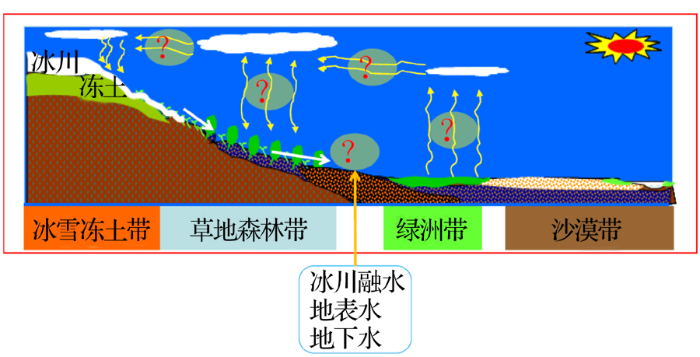
以上研究表明,要深入理解这些问题,其核心在于理解山区不同下垫面的水分来源、水分在土壤—植被—大气之间的迁移过程,以及水分在大气中的水平输移(图1)等,尽管目前国内外已经开始关注这些问题,但真正从流域尺度上,通过观测与模拟相结合的实证研究还较少,这也是科学上取得突破的难点。
图1 西北内陆河山区流域内循环过程概念图
Fig.1 Concept scheme of water internal recycle process of mountainous inland basin in Northwest China
针对以上问题,国家自然科学基金重点项目“西北内陆河山区流域水文内循环过程及机理研究”以认识干旱区内陆河山区流域内部的水循环过程和机理为研究目标,选择阿克苏河上游和疏勒河上游山区为主要研究对象。在已有观测的基础上,根据项目目标的需要,通过水文要素的观测试验、水分传输过程的示踪与模拟、流域水循环的机理分析开展相关研究。具体包括:
在2个拟开展研究流域现有观测基础上,针对不同下垫面特性,在流域不同高度带建立降水强化观测系统,加强对山区流域不同高度带降水空间分布的认识;在流域冰面、寒漠带、高寒草甸、高寒灌丛、森林等不同下垫面开展小流域径流观测试验研究,研究不同下垫面的水量平衡组成特点,同时对水文模型中不同下垫面类型中水分—能量传输过程中相关参数和算法进行改进,分析高寒山区不同典型下垫面水循环过程的差异。
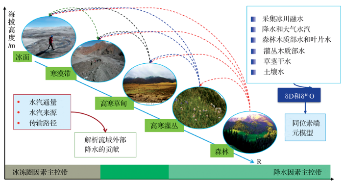
通过采集降水、土壤水、森林木质部水和叶片水、灌丛木质部水、高寒草地的草茎干水、大气水汽样品,研究不同下垫面(次)降水、浅层和深层土壤水及大气水汽等不同水体δD和δ18O时空变化规律及其与环境要素的关系(图2)。根据降水、大气水汽、土壤水及森林木质部水和叶片水、灌丛木质部水、草茎干水的δD和δ18O特征,叶片生理生态特征及环境要素(土壤水和气象要素)等,通过同位素端元模型分析不同下垫面蒸散发中的植物蒸腾和土壤蒸发组成特点,解析土壤蒸发和植被蒸腾对局地降水的贡献。在上述研究的基础上,利用NECR/NCEP再分析资料、高分辨率的HAR气候数据集(http://www.klima.tu-berlin.de/HAR),分析山区流域的水汽来源及传输路径。同时,在主要的水汽传输路径上结合加强的降水同位素采样和分析,解析不同下垫面间水汽输移对局地降水的不同贡献。
图2 基于同位素方法的流域尺度水分传输过程的示踪和模拟方案
Fig.2 Scheme of trace and simulate water transport process based on isotopic method
利用流域降水加密观测资料并结合卫星遥感降水数据,以及同位素分析资料,对中尺度气象模式(Weather Research and Forecasting model,WRF)进行不同空间分辨率的嵌套配置和模拟,分析山区流域大气水汽的水平输移过程和降水空间分布之间的关联机制。分析西风强度对阿克苏河夏季降水的影响,以及高原季风和西风不同年份波动对疏勒河水循环特征的影响。
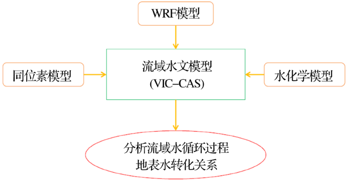
利用同位素分析结果、重力和重力反演与气候实验卫星(Gravity Recovery and Climate Experiment,GRACE)水储量变化、湖泊水位的动态成果等作为径流的间接验证,对由申请者团队改进的融合冰川、积雪和冻土变化的分布式水文模型VIC-CAS(Variable Infiltration Capacity-Chinese Academy Sciences)进行校验,并结合流域不同下垫面水循环过程观测实验的观测结果,改进模型,提高模拟精度。在此基础上,将同位素模型、分布式水文模型VIC-CAS与WRF进行耦合,分析流域内不同水文单元(下垫面)内及之间的水分传输和关联机制,结合地面观测和卫星遥感资料,分析过去30年不同年份西风强度对阿克苏河水循环过程的影响,以及高原季风和西风不同年份波动对疏勒河水循环过程的影响(图3)。
图3 基于水文模型的流域内循环机理模拟方案
Fig.3 Scheme of simulation on water internal recycle mechanism by hydrological model
尽管综合目前的观测结果已表明在内陆河山区流域可能存在较强的水分内循环机制,然而,目前对于该内循环机制的定量研究还未见报道,该研究创新性强,但也面临诸多挑战。 对于高山区,观测条件的限制对于获取完整、可靠的各下垫面的大气—土壤—植被中的水分迁移资料带来了很大挑战,从而对模拟带来了不确定性。另一方面,对于不同时空尺度的大气过程和水文过程研究,耦合问题上空间尺度不匹配是大部分参数误差的主要来源。过去的水汽来源研究主要应用在大尺度研究中,利用NCEP/NCEP, ERA-Interim等再分析资料在流域尺度上的可靠性目前还缺乏评估和验证, 不同再分析资料得到的水汽通量也存在差别。就同位素示踪来讲,主要根据同位素在不同地区的特征进行归因分析,而同位素本身也具有很强的时间和空间差异,也具有一定的不确定性。
就模型模拟看,Lakhtakia等[76] 在MM5模型通过3个不同空间分辨率的敏感性分析表明12 km的分辨率对于MM5是最合适的网格尺度,该尺度为气候变化的水文响应提供了足够的分辨率。余钟波[77] 认为12 km分辨率网格条件下,缩小区域气候模式 (Regional Climate Model,RCM) 和全球气候模式 (Global Climate Model,GCM) 网格分辨率的差距更有利于模型耦合,但仍需要减少尺度耦合问题的不确定性。此外,该研究涉及气象学、水文学、冰冻圈科学等多个学科,需要加强各学科间的协作,从不同角度、不同指标对山区流域的内循环机制进行探索和相对独立的验证,这也对研究队伍提出了更高的要求。
The authors have declared that no competing interests exist.
| [1] |
Cryopshere change and global warming: Impact and challenges in China [J].冰冻圈变化与全球变暖:我国面临的影响与挑战 [J].
本文从冰川的水文水资源效应、冻土的生态、气候和工程效应、积雪的水文及气候效应等方面论述了冰冻圈在我国社会经济发展中的影响与重要作用。在此基础上,着重根据近40年来我国冰冻圈变化的实际情况,论述了冰冻圈变化对水资源、生态、工程、灾害和气候所产生的一些影响。最后根据国内外冰冻圈研究发展趋势,总结了我国冰冻圈研究所面临的机遇、挑战与发展建议。
|
| [2] |
Elevation-dependent warming in mountain regions of the world [J].
There is growing evidence that the rate of warming is amplified with elevation, such that high-mountain environments experience more rapid changes in temperature than environments at lower elevations. Elevation-dependent warming (EDW) can accelerate the rate of change in mountain ecosystems, cryospheric systems, hydrological regimes and biodiversity. Here we review important mechanisms that contribute towards EDW: snow albedo and surface-based feedbacks; water vapour changes and latent heat release; surface water vapour and radiative flux changes; surface heat loss and temperature change; and aerosols. All lead to enhanced warming with elevation (or at a critical elevation), and it is believed that combinations of these mechanisms may account for contrasting regional patterns of EDW. We discuss future needs to increase knowledge of mountain temperature trends and their controlling mechanisms through improved observations, satellite-based remote sensing and model simulations.
|
| [3] |
Global response of glacier runoff to twenty-first century climate change [J].
The hydrology of many important river systems in the world is influenced by the presence of glaciers in their upper reaches. We assess the global-scale response of glacier runoff to climate change, where glacier runoff is defined as all melt and rain water that runs off the glacierized area without refreezing. With an elevation-dependent glacier mass balance model, we project monthly glacier runoff for all mountain glaciers and ice caps outside Antarctica until 2100 using temperature and precipitation scenarios from 14 global climate models. We aggregate results for 18 glacierized regions. Despite continuous glacier net mass loss in all regions, trends in annual glacier runoff differ significantly among regions depending on the balance between increased glacier melt and reduction in glacier storage as glaciers shrink. While most regions show significant negative runoff trends, some regions exhibit steady increases in runoff (Canadian and Russian Arctic), or increases followed by decreases (Svalbard and Iceland). Annual glacier runoff is dominated by melt in most regions, but rain is a major contributor in the monsoon-affected regions of Asia and maritime regions such as New Zealand and Iceland. Annual net glacier mass loss dominates total glacier melt especially in some high-latitude regions, while seasonal melt is dominant in wetter climate regimes. Our results highlight the variety of glacier runoff responses to climate change and the need to include glacier net mass loss in assessments of future hydrological change.
|
| [4] |
Changes in intra-annual runoff and its response to climate change and human activities in the headstream areas of the Tarim River Basin, China [J]. |
| [5] |
Statistical estimation of the impacts of glaciers and climate change on river runoff in the headwaters of the Yangtze river [J]. |
| [6] |
Climate change with elevation and its potential impact on water resources in the Tianshan mountains, central Asia [J]. |
| [7] |
Study on recent change of glacier [J].冰川变化研究近况 [J]. |
| [8] |
Variations of temperature and precipitation of snowmelt period and its effect on runoff in the mountainous areas of Northwest China [J]. |
| [9] |
The impacts of climate change on water resources and agriculture in China [J]. |
| [10] |
Research progress on the impact of climate change on water resources in the arid region of Northwest China [J].西北干旱区气候变化对水文水资源影响研究进展 [J]. |
| [11] |
Trends in runoff versus climate change in typical rivers in the arid region of Northwest China [J].
To clarify runoff and climate change trends and its relation in typical rivers in the arid region of northwest China (ANC), this study takes the runoff and meteorological data of 11 rivers in 5 typical river areas from mountain-pass as the research objects. The Mann–Kendall test, Extrapolation of Variance Analysis of Time-series Period and Correlation Analysis Method are applied to analyze the temporal and spatial variations of climate and runoff. The results show that in the past 50 years, the temperature, precipitation and runoff in the each river area exhibited an upward tendency. However, the runoff from the south slope of Altai Mountains and the north slope of Kunlun Mountains and the precipitation on the north slope of Qilian Mountains, the north slope of Kunlun Mountains and the south slope of Tianshan Mountains show inconspicuous changes. The increasing rates of temperature and precipitation in the river area of Northern Xinjiang is the largest, an average of 0.4402°C/10a and 15.3902mm/10a; followed by that in the river area of Hexi Corridor, 0.2902°C/10a and 7.6402mm/10a. The lowest one is in the river area of Southern Xinjiang, only 0.2402°C/10a and 5.5002mm/10a. However, the increasing rate of runoff is the slowest in Northern Xinjiang while that in Southern Xinjiang is the fastest, mainly related to runoff recharge difference. The runoff recharge proportions from glaciers and precipitation have great effects on the relation between runoff and temperature and precipitation.
|
| [12] |
Impacts of climate change and vegetation dynamics on runoff in the mountainous region of the Haihe River basin in the past five decades [J]. |
| [13] |
Impact of mountain permafrost on flow path and runoff response in a high alpine catchment [J].
Permafrost in high alpine catchments is expected to disappear in future warmer climates, but the hydrological impact of such changes is poorly understood. This paper investigates the flow paths and the hydrological response in a 5 kmhigh alpine catchment in the 脰tztal Alps, Austria, and their changes resulting from a loss of permafrost. Spatial permafrost distribution, depth to the permafrost table, and depth to the bedrock were mapped by geophysical methods. Catchment runoff and meteorological variables were monitored from June 2008 to December 2011. These data were used along with field experience to infer conceptual schemes of the dominant flow paths in four types of hillslopes that differ in terms of their unconsolidated sediment characteristics and the presence of permafrost. The four types are: talus fans, rock glaciers, Little Ice Age (LIA) till, and pre-LIA till. Permafrost tends to occur in the first three types, but is absent from pre-LIA till. Based on these flow path concepts, runoff was simulated for present conditions and for future conditions when permafrost has completely disappeared. The simulations indicate that complete disappearance of permafrost will reduce flood peaks by up to 17% and increase runoff during recession by up to 19%. It is argued that change modeling needs to account for flow path types and their changes based on geophysical surveys and field investigations.
|
| [14] |
Impacts of climate change on the water cycle mechanism and water resources security in the arid region of Northwest China [J].气候变化对西北干旱区水循环影响机理与水资源安全研究 [J].
西北干旱区是对全球变化响应最敏感的地区之一,"气候变化对西北干旱区水循环影响机理与水资源安全研究"项目,以全球变化背景下的西北干旱区气候-水文过程、水循环机理、水资源形成与转化以及未来变化趋势为主线,重建了过去300年西北干旱区气候变化序列,分析了气候变化对水循环关键过程和水系统的影响,构建了适合山盆地貌格局的水文、水资源模型,分析了未来水资源变化趋势,得出了一系列有意义的结论:在过去300年间,西北干旱区以冷干、暖湿气候类型交替出现,存在40年的变化周期;在近50年,温度、降水出现了"突变型"升高,自1997年以来,升温滞缓,处于高位震荡;蒸发潜力由显著下降逆转为显著上升趋势,水循环过程加剧;极端气候水文事件频度增强、频率加大,水文波动性增强、水资源不确定性增大;天山山区冰川加速退缩,冰雪水储量呈减少态势,部分河流出现冰川消融拐点;水系统安全性降低,供需水矛盾会进一步加剧;伴随气温的高位震荡和地下水的超采,西北干旱区的生态隐忧和潜在风险加大。
|
| [15] |
Advances in synthetic research on the eco-hydrological process of the Heihe River Basin [J].黑河流域生态—水文过程集成研究进展 [J].
<p>国家自然科学基金重大研究计划“黑河流域生态—水文过程集成研究”(简称黑河计划)贯穿地球系统科学的思维, 针对我国内陆河地区严峻的水—生态问题, 探索流域尺度提高水效益的理论和方法。计划执行4年来, 建立了遥感—监测—实验一体的流域生态水文观测系统及其相应的数据平台; 初步揭示了流域冰川、森林、绿洲等重要生态水文过程耦合机理, 认识了流域一级生态水文单元的水系统特征, 奠定了流域水循环、水平衡的科学基础; 计算了黑河下游生态需水量, 为黑河流域水资源优化管理厘定了重要的约束条件。今后几年将在高精度气、水、生、经时空数据的支持下, 耦合与集成流域综合模型, 保证我国流域科学能在世界前沿占一席之地。</p>
|
| [16] |
Model development and verification [J].
黑河流域水循环系统的分布式模拟(I) ——模型开发与验证 [J].
从水循环的物理机制着手,在考虑人工侧支循环的基础上,以现代地理信息技术为数据处理平台, 开发了黑河流域水循环系统的分布式模拟模型.文中系统描述了模型结构,从水循环过程和能量循环过程2个方面对模型各要素的过程模拟进行了阐述,其中水循环 过程包括蒸发蒸腾、入渗与径流、地下水运动、地下水流出和地下水溢出、坡面汇流与河道汇流、人工侧支循环等要素过程.在获取各类输入参数后,采用1km网 格、以日为时间步长对黑河流域上、中游地区(36 728个网格单元)进行了1981~2002年的逐日模拟.结果表明,所建立的分布式模型对月径流过程和日平均流量过程具有较高模拟精度.校正期内前后两 个验证期均得到良好验证.该模型可用于预测未来环境变化条件下流域水资源演变.
|
| [17] |
SAHRA: Sustainability ofSemi Arid Hydrology and Riparian Areas Final Report[R] .
|
| [18] |
Heihe Watershed Allied Telemetry Experimental Research(HiWATER): Scientific objectives and experimental design [J]. |
| [19] |
Impact of cryosphere hydrological processes on the river runoff in the upper reaches of Heihe River [J].
冰冻圈水文过程对黑河上游径流的影响分析 [J].
黑河上游处于高寒山区,开展冰冻圈水文过程对径流的影响研究,对于判断该地区径流变化趋势及其可持续性具有重要意义。本文应用基流分割、逐步多元回归等方法,分析了1960—2013年黑河上游出山径流量的变化及其原因,重点估计了融雪、冰川融化对径流的贡献,探讨了土壤冻融过程对径流变化的可能影响。分析结果表明,黑河上游山区河川径流在近54年间呈现上升趋势,其中以基流部分的上升为主。降水与气温变化对河川径流上升均有较大贡献。导致春季径流增加的主要因素为温度、降水次之;导致秋季径流增加的主要因素为降水、温度次之。夏季黑河上游东支的雨强有显著增大趋势(日雨量增幅为0.9 mm/10 a),对于河川径流贡献的比例约为15%。黑河山区的逐年降雪量变化不显著,冰川融化对径流增加的贡献小于10%。由此推断气温上升导致基流增加的主要原因是:气温升高导致高寒山区冻土活动层增厚,增加了土壤蓄水容量,从而导致降雨下渗量增加和基流量增大。由于黑河上游冻土分布广泛,未来气温持续上升的情况下,这种产流机制变化导致的基流增加具有可持续性。
|
| [20] |
|
| [21] |
Hydrological processes in the different landscape zones of alpine cold regions in the wet season, combining isotopic and hydrochemical tracers [J]. |
| [22] |
Hydrometeorological observation and study in high altitude area [J].URL 摘要
中国科学院寒区旱区环境与工程研究所机构知识库(CASNW OpenIR)以发展机构知识能力和知识管理能力为目标,快速实现对本机构知识资产的收集、长期保存、合理传播利用,积极建设对知识内容进行捕获、转化、传播、利用和审计的能力,逐步建设包括知识内容分析、关系分析和能力审计在内的知识服务能力,开展综合知识管理。
|
| [23] |
Study of statistical characteristics of wet season hourly rainfall at Hulu watershed with Г function in Qilian Mountains [J].基于Γ函数的祁连山葫芦沟流域湿季小时降水统计特征 [J].
高山区降水主要集中在湿季(5~9月),湿季小时降水的概率分布统计特征是研究山区降水分布的重要基础。选择祁连山中段典型流域为研究区,使用葫芦沟流域6个观测点2015年5~9月半小时降水数据,采用极大似然法对影响Γ分布函数的形状参数<em>α</em>和尺度参数<em>β</em>进行估计,并且对不同强度降水概率密度分布、累计概率密度以及降水概率与海拔和降水量关系进行分析。结果表明:形状参数<em>α</em>和尺度参数<em>β</em>呈明显负相关,形状参数α与小时平均降水量分布大致相同;在葫芦沟流域,除海拔因素外,局地地形也是影响降水再分配和降水概率分布的重要因素;在该流域,除降水事件增加外, 1~3 mm/h强度降水概率随着海拔增加而增加也是降水量随海拔增加而增加的主要原因。
|
| [24] |
A cryosphere-hydrology observation system in a small Alpine watershed in the Qilian Mountains of China and its meteorological gradient [J]. |
| [25] |
Coupling a glacier melt model to the Variable Infiltration Capacity (VIC) model for hydrological modeling in north-western China [J]. |
| [26] |
Modeling hydrologic response to climate change and shrinking glaciers in the highly glacierized Kunma Like River Catchment, Central Tian Shan [J]. |
| [27] |
Glaciers in the Earth’shydrological cycle: Assessments of glacier mass and runoff changes on global and regional scales [J]. |
| [28] |
Assessing streamflow sensitivity to variations in glacier mass balance [J].
We examine long-term streamflow and mass balance data from two Alaskan glaciers located in climatically distinct basins: Gulkana Glacier, a continental glacier located in the Alaska Range, and Wolverine Glacier, a maritime glacier located in the Kenai Mountains. Over the 1966 2011 study interval, both glaciers lost mass, primarily as a result of summer warming, and streamflow increased in both basins. We estimate total glacier runoff via summer mass balance and quantify the fraction of runoff related to annual mass imbalances. In both climates, annual (net) mass balance contributes, on average, less than 20% of total streamflow, substantially less than the fraction related to summer mass loss (>50%), which occurs even in years of glacier growth. The streamflow fraction related to changes in annual balance increased significantly only in the continental environment. In the maritime climate, where deep winter snowpacks and frequent rain events drive consistently high runoff, the magnitude of this streamflow fraction was small and highly variable, precluding detection of any existing trend. Furthermore, our findings suggest that glacier mass change is likely to impact total basin water yield, timing of runoff and water quality in the continental environment. However, the impacts of maritime glacier change appear more likely to be limited to water quality and runoff timing.
|
| [29] |
The influence of seasonally frozen soil on the snowmelt runoff at two Alpine sites in southern Switzerland [J]. |
| [30] |
Variation of hydrological regime with permafrost coverage over Lena Basin in Siberia [J].
[1] We use monthly discharge and permafrost data to examine the relationship between discharge characteristics and basin permafrost coverage for the nested subbasins of the Lena River in Siberia. There are similarity and variation in streamflow regimes over the basin. The ratios of monthly maximum/minimum flows directly reflect discharge regimes. The ratios increase with drainage area from the headwaters to downstream within the Lena basin. This pattern is different from the nonpermafrost watersheds, and it clearly reflects permafrost effect on regional hydrological regime. There is a significant positive relationship between the ratio and basin permafrost coverage. This relationship indicates that permafrost condition does not significantly affect streamflow regime over the low permafrost (less than 40%) regions, and it strongly affects discharge regime for regions with high permafrost (greater than 60%). Temperature and precipitation have similar patterns among the subbasins. Basin precipitation has little association with permafrost conditions and an indirect relation with river flow regimes. There exists a good relation between the freezing index and permafrost extent over the basin, indicating that cold climate leads to high coverage of permafrost. This relation relates basin thermal condition with permafrost distribution. The combination of the relations between temperature versus permafrost extent, and permafrost extent versus flow ratio links temperature, permafrost, and flow regime over the Lena basin. Over the Aldan subbasin, the maximum/minimum discharge ratios significantly decrease during 1942 1998 due to increase in base flow; this change is consistent in general with permafrost degradation over eastern Siberia.
|
| [31] |
Monitoring of frozen soil hydrology in macro-scale in the Qinghai-Xizang Plateau [J]. |
| [32] |
The active-layer hydrology of a peat plateau with thawing permafrost (Scotty Creek, Canada) [J].
The southern margin of permafrost is experiencing unprecedented rates of thaw, yet the effect of this thaw on northern water resources is poorly understood. The hydrology of the active layer on a thawing peat plateau in the wetland-dominated zone of discontinuous permafrost was studied at Scotty Creek, Northwest Territories (Canada), from 2001 to 2010. Two distinct and seasonally characteristic levels of unfrozen moisture were evident in the 0.7-m active layer. Over-winter moisture migration produced a zone of high ice content near the ground surface. The runoff response of a plateau depends on which of the three distinct zones of hydraulic conductivity the water table is displaced into. The moisture and temperature of the active layer steadily rose with each year, with the largest increases close to the ground surface. Permafrost thaw reduced subsurface runoff by (1) lowering the hydraulic gradient, (2) thickening the active layer and, most importantly, (3) reducing the surface area of the plateau. By 2010, the cumulative permafrost thaw had reduced plateau runoff to 47 % of what it would have been had there been no change in hydraulic gradient, active layer thickness and plateau surface area over the decade.
|
| [33] |
Use of distributed snow measurements to test and improve a snowmelt model for predicting the effect of forest clear-cutting [J]. |
| [34] |
Climate change impacts on the hydrology of a snowmelt driven basin in semiarid Chile [J].
In this paper we present an analysis of the direct impacts of climate change on the hydrology of the upper watersheds (range in elevation from 1,000 to 5,50002m above sea level) of the snowmelt-driven Limarí river basin, located in north-central Chile (30° S, 70° W). A climate-driven hydrology and water resources model was calibrated using meteorological and streamflow observations and later forced by a baseline and two climate change projections (A2, B2) that show an increase in temperature of about 3–4°C and a reduction in precipitation of 10–30% with respect to baseline. The results show that annual mean streamflow decreases more than the projected rainfall decrease because a warmer climate also enhances water losses to evapotranspiration. Also in future climate, the seasonal maximum streamflow tends to occur earlier than in current conditions, because of the increase in temperature during spring/summer and the lower snow accumulation in winter.
|
| [35] |
Key research topics and their advances on modeling snow hydrological processes [J].积雪水文模拟中的关键问题及其研究进展 [J].
<p>针对近年来积雪水文模拟研究的发展趋势, 在简要评述积雪模拟基本方法的基础上, 分别就各类方法的不同着眼点展开讨论, 从模拟方案的简繁、 积雪面积等重要状态变量在模型中如何体现等角度进行了叙述.针对我国青藏高原积雪特征, 提炼出现阶段空间分布式积雪水文模拟中的3个关键问题: 网格尺度积雪空间异质性的模拟、 风吹雪的空间参数化、 季节性冻土下垫面的融雪模拟. 分别就这些问题, 回溯了国内外最新研究进展, 强调了发展积雪衰减曲线在网格尺度积雪模拟中的重要性, 讨论了山区环境中具有操作性的风吹雪空间参数化方案, 分析了冻土下垫面融雪研究存在的一些具体问题.</p>
|
| [36] |
Progress in Hydrological Modeling over High Latitudes: Under Arctic Climate System Study (ACSYS) [M] |
| [37] |
The hydrological impact of cryosphere water cycle on global-scale water cycle [J].冰冻圈水循环在全球尺度的水文效应 [J].
以固态形式存在的冰冻圈诸要素,其冻、融过程导致水循环发生重要变化,进而影响大洋、河流水文过程及大气水分循环过程.本文在分析两极地区海洋淡水组成的基础上,论述了两极地区冰冻圈对大洋输入淡水的影响,阐释了冰冻圈与大洋热盐环流的关系,讨论了冰冻圈对海平面上升的贡献程度.研究指出,在南、北纬60o-90o范围南、北极海洋的淡水年循环中,海冰和北极融雪参与的水量远超过降水-蒸发过程的水循环量;北极融雪与河流补给、山地冰川、冰帽及格陵兰冰盖、南极冰盖、海冰、冰间湖等冰冻圈要素的变化可以显著地影响海洋深水对流强度及深水的形成,从而影响海洋热盐环流.冰冻圈对海平面变化影响的评估仍然存在较大的不确定性.从1990年开始的5次IPCC评估报告中,历次对海平面上升贡献的评估结果相差较大.总体来看,若不考虑陆地水储量变化的影响,在海洋热膨胀和冰冻圈这两大影响因子中,工业化升温以来对海平面上升的贡献各占一半.
|
| [38] |
Frozen soil parameterization in a distributed biosphere hydrological model [J].
In this study, a frozen soil parameterization has been modified and incorporated into a distributed biosphere hydrological model (WEB-DHM). The WEB-DHM with the frozen scheme was then rigorously evaluated in a small cold area, the Binngou watershed, against the in-situ observations from the WATER (Watershed Allied Telemetry Experimental Research). First, by using the original WEB-DHM without the frozen scheme, the land surface parameters and two van Genuchten parameters were optimized using the observed surface radiation fluxes and the soil moistures at upper layers (5, 10 and 20 cm depths) at the DY station in July. Second, by using the WEB-DHM with the frozen scheme, two frozen soil parameters were calibrated using the observed soil temperature at 5 cm depth at the DY station from 21 November 2007 to 20 April 2008; while the other soil hydraulic parameters were optimized by the calibration of the discharges at the basin outlet in July and August that covers the annual largest flood peak in 2008. With these calibrated parameters, the WEB-DHM with the frozen scheme was then used for a yearlong validation from 21 November 2007 to 20 November 2008. Results showed that the WEB-DHM with the frozen scheme has given much better performance than the WEB-DHM without the frozen scheme, in the simulations of soil moisture profile at the cold regions catchment and the discharges at the basin outlet in the yearlong simulation.
|
| [39] |
Inclusion of glacier processes for distributed hydrological modeling at basin scale with application to a watershed in Tianshan Mountains, Northwest China [J]. |
| [40] |
Discharge regime and simulation for the upstream of major rivers over Tibetan Plateau [J].
[1] The hydrological regimes for the major river basins in the Tibetan Plateau (TP), including the source regions of the Yellow (UYE), Yangtze (UYA), Mekong (UM), Salween (US), Brahmaputra (UB), and Indus (UI) rivers, were investigated through a land surface model and regression analyses between climate variables and runoff data. A hydrologic modeling framework was established across the TP to link the Variable Infiltration Capacity (VIC) land surface hydrology model with a degree-day glacier-melt scheme (VIC-glacier model) at a 1/12° × 1/12°. The model performance was evaluated over the upper basins of the six rivers. The heterogeneity and scarcity of the meteorological stations are the major limitation for hydrological modeling over the TP. The relative contributions to streamflow from rainfall, snowmelt, and glacier melt for the six basins were quantified via the model framework and simulation. The results suggest that monsoon precipitation has a dominant role in sustaining seasonal streamflow over southeastern regions, contributing 65–78% of annual runoff among the UYE, UYA, UM, US, and UB basins. For the UI, the runoff regime is largely controlled by the glacier melt and snow cover in spring and summer. The contribution of glacier runoff is minor for the UYE and UM (less than 2% of total annual flow), and moderate for the UYA and US basins (5–7% of yearly flow), while glacier melt makes up about 12% and 48% of annual flow for the UB and UI basins, respectively.
|
| [41] |
Hydrological response to future climate changes for the major upstream river basins in the Tibetan Plateau [J]. |
| [42] |
Effect of forest on annual water yield in the mountains of an arid inland river basin: A case study in the Pailugou catchment on northwestern China’s Qilian Mountains [J]. |
| [43] |
Review on montane forest eco-hydrology in arid area [J].干旱区山地森林生态水文研究进展 [J].
在全球气候变化背景下,干旱区山地森林及其与水的关系和水文功能表现出较强的敏感性,引起了学术界和管理部门的高度关注。从森林空间格局、生态水文过程及其对气候变化的响应等方面,系统阐述了干旱区山地森林生态水文的研究进展,辨析了森林斑块格局的形成与稳定机理、森林与流域产水量的关系以及森林生态水文对气候变化的响应。此外,结合目前的研究进展,提出了未来的研究重点:加强植被格局与水文过程的耦合研究;借助遥感技术和模型解决尺度问题;提升森林水文功能的认识水平;确定兼顾水文和其他生态效应的适宜森林规模。
|
| [44] |
Vegetation primary production estimation at maize and alpine meadow over the Heihe River Basin, China [J]. |
| [45] |
Seasonal variations of the water budget in typical grassland ecosystems in China [J].
Regional droughts may become more frequent this century as a result of anthropogenic global climate change. Thus, it is becoming critically important to evaluate the water budget accurately in terrestrial ecosystems. The water budget, which represents an important index for drought, is widely used to characterize water cycle processes in terrestrial ecosystems and to inform management decisions regarding regional water resources. As a vital component of the terrestrial biosphere, grassland ecosystem plays crucial role in regional carbon sinks and sources especially that located in the Qinghai-Tibet Plateau. In this study, based on water balance method, seasonal variations of water budget were analyzed using flux data obtained from eddy covariance measurements from 2004 to 2011 in an alpine meadow in Damxung (DX), an alpine shrubland in Haibei (HBGC), and aLeymus chinensisgrassland in Inner Mongolia (NMG). We found that seasonal variations of water budget were quite different among the three ecosystems. The average water budget were (6181.48±76.56) mm, (6135.97±81.70) mm, and (6153.05±56.91) mm for DX, HBGC, and NMG, respectively. Water surplus happened from June to August in DX with an amount of (52.04±68.15) mm, while water deficit existed during the other months of the year with an amount of (61133.51±42.62) mm. There was little evidence of water deficit in HBGC at the yearly scale. However, seasonal water surplus occurred from May to September with an average of (30.11±67.47) mm and water deficiency were noted during the other months of the year with an average of (6166.08±25.87) mm. Due to lack of precipitation in NMG, water deficiency occurred from January to March, and the amount of deficiency during this time period was (6118.01±17.95) mm. Although precipitation was ample from April to October, water deficiency still occurred in NMG as a result of high evapotranspiration (i.e., the deficiency was approximately (6139.99±70.49) mm). In addition, the water budget and net ecosystem productivity showed consistent trends during the study period. Net ecosystem productivity was relatively higher from June to August when there were ample precipitation and water surplus than that of months with water deficit. Further studies need to be done in the future to address the complex influence of rain intensity and soil water balance on ecosystem productivity.
|
| [46] |
Study on water budget of the typical shrub and arbor woods in sandy land of Northwest Liaoning Province [J].辽宁西北部沙地主要乔灌木林地水量平衡研究 [J].
以定位观测资料为基础,对辽宁西北部(以下简称辽西北)沙地荒草地、樟子松林、油松林、杨树 林、松杨混交林、山杏林、榆树疏林的水量平衡进行了研究。结果表明:辽西北沙地不同植物群落类型土壤贮水量与降雨量的线性相关极显著,荒草地的土壤贮水量 优于任何人工植物群落类型。山杏灌木林群落蒸散量最高,为516.09mm,松杨混交林群落次之,为495.79mm,这两种植物群落蒸散量大于同期降雨 量461.00mm,植物群落的水量不平衡;荒草地、樟子松林地、油松林地、杨树林地的蒸散量均小于同期降雨量,榆树疏林蒸散量次小,仅为 381.34mm,这5类植物群落基本能够维持土壤水量平衡。
|
| [47] |
Low coverage sand control theory and its application in arid and semi-arid areas [J].低覆盖度治沙理论及其在干旱半干旱区的应用 [J].
低覆盖度治沙理论是以疏林或稀疏灌丛植被格局的演变为内涵,外延出优化格局的风沙物理和生态水文原理与过程;组合了林学边行优势与生态学界面效益理论,形成的一套人工治理与自然修复有机结合的生态修复理论。该理论开创了植被在低覆盖度(15%-25%)下实现防沙治沙目标的新领域,显著提高了稀疏植被的阻风固沙和水分利用效率,提出了不同生物气候区低覆盖度治沙的控制密度和基本原则,支撑了2015年《国家造林技术规程》(旱区部分)的修订。低覆盖度治沙理论已成为指导我国防沙治沙工程的重要理论,引领了一个崭新的研究方向,有力地推进了防沙治沙事业的进步。
|
| [48] |
soil moisture dynamics and water balance of salix psammophila shrubs in south edge of mu us sandy land [J]. |
| [49] |
Hydrology, ecology and climate significance and its research progress of the alpine cold desert [J].高山寒漠带水文、生态和气候意义及其研究进展 [J].
<p> 高山寒漠带在青藏高原和天山地区的面积比率约为20%~30%,在高海拔山区面积分布广阔,是山区流域降水的高值区,下渗迅速,产流系数高,是山区流域的主要产流区。由于其海拔高、气温低、地形陡峭、植被稀疏,是重要的水文功能区和极端寒区生态脆弱区,附生在其中的稀疏植被和低温微生物是高山生命带的重要组成部分,对气候变化也有指示意义,但国内相关研究很少。人类活动对高山寒漠生境植被的影响比低海拔区要小,因而为我们提供了一个可以进行气候变化效应比较监测的机会。提出高山寒漠带在我国冰冻圈水文、生态和气候等方面的重要性,并对相关进展进行初步总结,建议将高山寒漠带作为一个特殊的生态、气候和水文功能区,专门进行研究。<br /></p>
|
| [50] |
Hydrological processes in the different landscape zones of alpine cold regions in the wet season, combining isotopic and hydrochemical tracers [J]. |
| [51] |
A simple model to estimate ice ablation under a thick debris layer [J].
This paper presents a simple model to estimate ice ablation under a thick supraglacial debris cover. The key method employed in the model is to establish a link between the debris heat flux and the debris temperature at a certain depth when the heat transfer in the debris is described by a diffusion process. Given surface temperature, debris thermal properties and relevant boundary conditions, the proposed model can estimate mean debris temperature at interfaces of different debris layers using an iterative procedure, and then the heat flux for ice ablation. The advantage of the proposed model is that it only requires a few parameters to conduct the modeling, which is simpler and more applicable than others. The case study on Koxkar glacier, west Tien Shan, China, shows, in general, that the proposed model gives good results for the prediction of debris temperatures, except for an apparent phase shift between modeled and observed values. We suggest that this error is mainly due to complex phase relations between debris temperature and debris heat flux. The modeled ablation rates at three experimental sites also show good results, using a direct comparison with observed data and an indirect comparison with a commonly used energy-balance model.
|
| [52] |
Regimes of runoff components on the debris-covered Koxkar Glacier in western China [J]. |
| [53] |
Recent shrinkage and hydrological response of Hailuogou glacier, a monsoon temperate glacier on the east slope of Mount Gongga, China [J]. |
| [54] |
The hydrological linkage of mountains and plains in the arid region of northwest China [J]. |
| [55] |
An evaluation of satellite remote sensing data products for land surface hydrology: Atmospheric infrared sounder [J]. |
| [56] |
|
| [57] |
Progress in application of remote sensing data in hydrological simulation [J].遥感数据在水文模拟中的应用研究进展 [J]. |
| [58] |
Isotopic, chemical characteristics and transforming relationship between surfacewater and groundwater in the Xiaochangma river basin [J].小昌马河流域地表水地下水同位素与水化学特征及转化关系 [J]. |
| [59] |
Quantification analysis of water sources of desert plants in Qaidam Basin: A case study of Golmud plot [J].柴达木盆地荒漠植物水分来源定量研究——以格尔木样区为例 [J].
选择柴达木盆地的格尔木作为研究区域,选取沙拐枣、合头草、驼绒 藜和麻黄4种典型的地带性荒漠灌木,应用稳定氢氧同位素技术定量分析典型荒漠植物的水分来源.结果表明:①柴达木盆地典型荒漠植物能灵活利用各种水源(河 水、地下水、降水和土壤水等),最主要的水源是土壤水.②不同种类植物水分利用方式存在差异:驼绒藜、麻黄和沙拐枣主要利用深层土壤水和地下水,合头草以 土壤水为优势水源.③植物水分来源的时间变化为:生长季初期,植物主要利用河水和地下水;生长季中后期,合头草主要利用浅层土壤水,其他3种植物主要利用 较深层土壤水和地下水.
|
| [60] |
Isotopic evidence for the moisture origin and composition of surface runoff in the headwaters of the Heihe River Basin [J]. |
| [61] |
Stable isotopes in water vapor and precipitation for a coastal lagoon at mid latitudes [C]// |
| [62] |
Hydrological characteristics in non-freezing period at the alpine desertzone of Hulugou watershed, Qilian Mountains [J].祁连山葫芦沟流域高山寒漠带非冻结期水文特征 [J]. |
| [63] |
The patterns and implications of diurnal variations in d-excess of plant water, shallow soil water and air moisture [J]. |
| [64] |
Analysis on water vapor characteristics of two extreme rainstorm events in Western Gansu Corridor [J].河西走廊西部两次极端暴雨事件水汽特征分析 [J].
<p>利用常规观测资料、地面自动站雨量资料和NCEP 1°×1°再分析资料,应用水汽通量诊断分析、后向轨迹模型等方法分析了2012年6月4-5日(简称"0605")和2011年6月15-16日("0616")河西走廊西部干旱区两次极端暴雨事件的水汽输送和收支特征。结果表明,高原低涡及其前部弱高压脊共同作用下,在甘肃中西部对流层中层形成的异常偏东气流是河西走廊西部暴雨水汽输送的关键,其将来自孟加拉湾的水汽接力式的输送到河西走廊西部,有利于该地区的水汽辐合;弱高压脊的强度和位置决定了异常偏东气流的强度和最西端延伸的位置,而异常偏东气流的强度和最西端延伸的位置在很大程度上又决定了暴雨水汽的主要来源;两次暴雨过程均存在两路异常的水汽输送,随西风气流的西路水汽输送和绕高原的东路水汽输送,"0605"过程弱高压脊位置偏东偏弱,异常偏东气流由东向西扩展,最西端达到张掖,较强的西路水汽输送贡献率达到了90.02%,而"0616"过程弱高压脊位置偏西偏强且在内蒙古西部形成闭合的反气旋环流,异常偏东气流由西向东扩展,最西端位于酒泉西部,较强的东路水汽输送贡献率达到了84.6%;西(东)路水汽输送在对流层低(中)层输入较为显著。</p>
|
| [65] |
A review of climatic controls on δ18O in precipitation over the Tibetan Plateau: Observations and simulations [J]. |
| [66] |
Stable oxygen isotope differences between the areas to the north and south of Qinling Mountains in China reveal different moisture sources [J]. |
| [67] |
Effect of climate factors on streamflow in the alpine catchment of the Qilian Mountains [J].祁连山区流域径流影响因子分析 [J].
本文选取祁连山内陆流域,采用多元性回归月径流模型,对回归系数进行了适当当处理,分别得到标准化系统矩阵和径流因子矩阵,通过矩阵元素的方向和大小来判断各参数变量对径流的影响程度。
|
| [68] |
Study on the vertical distribution of precipitation in mountainous regions using TRMM data [J].基于TRMM 降水数据的山区降水垂直分布特征 [J].
选择天山和祁连山区为典型区,利用台站降水数据验证以上两区多卫星降水数据(TRMM)精度的基础上,借助TRMM数据分析了所选山区年降水梯度效应,并探讨了天山及祁连山最大降水高度带.结果表明,多卫星降水数据在天山和祁连山区精度较高,天山及祁连山年降水量都明显受到海拔影响,降水随海拔升高而增加,但天山降水与海拔正相关关系最好,南、北和西坡相关系数分别为0.90、0.81和0.58,多年平均降水直减率分别为11.0mm/100 m、6.3 mm/100 m、7.4 mm/100 m,最大降水高度带则分别位于海拔2 200~3 500 m和3 200~3 700 m和3 000m左右;祁连山东、中、西段降水随海拔有增加趋势,但降水梯度效应在祁连山东段明显高于祁连山中西段地区,梯度效应由东向西呈现递减趋势,其最大降水带主要分布在东段4 000~4 500 m的高山带.
|
| [69] |
Glacier melt:A review of processes and their modelling [J]. |
| [70] |
Quantifying low rates of summertime sublimation for buried glacier ice in Beacon Valley, Antarctica [J]. |
| [71] |
Summertime surface energy budget and ablation modeling in the ablation zone of a maritime Tibetan glacier [J]. |
| [72] |
The surface energy budget in the accumulation zone of the Laohugou Glacier No. 12 in the western Qilian Mountains, China, in summer 2009 [J]. |
| [73] |
The Differences in the Mass and Energy Balance of Representative Glaciers in Westerlies and Indian Summer Monsoon Region on the Tibetan Plateau and Analyzed Mechanism for These Difference[D] .青藏高原西风区与季风区典型冰川物质—能量平衡变化差异及其机制研究[D] . |
| [74] |
Transpiration in the global water cycle [J].
A compilation of 81 studies that have partitioned evapotranspiration (ET) into its components—transpiration (T) and evaporation (E)—at the ecosystem scale indicates that T accounts for 61% (±15% s.d.) of ET and returns approximately 39±10% of incident precipitation (P) to the atmosphere, creating a dominant force in the global water cycle. T as a proportion of ET is highest in tropical rainforests (70±14%) and lowest in steppes, shrublands and deserts (51±15%), but there is no relationship of T/ET versus P across all available data (R2=0.01). Changes to transpiration due to increasing CO2 concentrations, land use changes, shifting ecozones and climate warming are expected to have significant impacts upon runoff and groundwater recharge.
|
| [75] |
Characteristics and spatio-temporal variability of the Amazon River basin water budget [J].
The spatio-temporal variations of the water budget components in the Amazon region are investigated by using a combination of hydrometeorological observations and moisture fluxes derived from the NCEP/NCAR reanalyses, for the period 1970–1999. The key new finding of this study identifies the major differences in the water balance characteristics and variability between the northern and southern parts of the basin. Our results show that there is a seasonality and interannual variability of the water balance that varies across the basin. At interannual time scales, anomalies in the water balance components in the northern Amazon region show relatively stronger links with tropical Pacific interannual variability. Over the entire region, precipitation exceeds evaporation and the basin acts as a sink of moisture ( P > E ). However, on some occasions the basin can act as a source for moisture ( P < E ) under extreme conditions, such as those related to deficient rainfall in northern Amazonia during the strong El Ni09o of 1983. Our estimates of the Amazon region’s water balance do not show a closure of the budget, with an average imbalance of almost 50%, suggesting that some of the moisture that converges in the Amazon region is not accounted for. The imbalance is larger over the southern Amazon region than over the northern region, and it also exhibits interannual variability. Large uncertainties are detected in the evaporation and moisture-convergence fields derived from the reanalyses, and in the case of evaporation it can be as large as 10–20% when compared with the few field observations across the basin. Observed precipitation fields derived from station data and from grid-box products also show some discrepancies due to sampling problems and interpolation techniques. The streamflow observed at the mouth of the river is obtained after corrections on the series observed taken at a gauging site almost 200km inland. However, variability in the evaporation, moisture convergence, and observed rainfall and runoff matches quite well.
|
| [76] |
A simulation of river-basin response to mesoscale meterological forcing: The Susquehanna River Basin Experiment (SRBEX) [J]. |
| [77] |
|

/
| 〈 |
|
〉 |
