
王文科 , 宫程程, 张在勇, 陈立
长安大学环境科学与工程学院,旱区地下水文与生态效应教育部重点实验室,陕西 西安 710054
Wang Wenke, Gong Chengcheng, Zhang Zaiyong, Chen Li
中图分类号: P641
文献标识码: A
文章编号: 1001-8166(2018)07-0702-17
收稿日期: 2018-03-26
修回日期: 2018-06-16
网络出版日期: 2018-07-20
版权声明: 2018 地球科学进展 编辑部
基金资助:
作者简介:
First author: Wang Wenke(1962-), male, Qishan County, Shaanxi Province, Professor. Research areas include subsurface hrdrology and ecological effects in arid regin. E-mail:wenkew@chd.edu.cn
作者简介:王文科(1962-),男,陕西岐山人,教授,主要从事旱区地下水文与生态效应方面的研究.E-mail:wenkew@chd.edu.cn
展开
摘要
围绕旱区地下水文与生态效应面临的科学问题以及国家生态文明与“一路一带”建设对地下水学科研究需求的紧迫性,分析了旱区地下水形成演化机理,研究了旱区地下水的功能。在此基础上,围绕6个重大科学问题分析了国内外研究现状、存在的问题与发展趋势,针对旱区地下水文与生态效应研究存在的瓶颈和国家的需求,提出了亟待解决的关键科学问题,助力于我国地下水科学的创新发展和国家经济建设。
关键词:
Abstract
Centering on the scientific problems faced by subsurface hydrology in arid regions and ecological effect, the urgency of national ecological civilization and the Belt and Road construction towards the research of groundwater discipline, this article analyzed the formation and evolution mechanisms of groundwater and studied the groundwater function of arid regions. Based on the analysis and research, this article discussed domestic and overseas research status, existing problems and developing trend from six aspects, raised key and scientific problems which urgently need to be addressed, aiming at the existing bottlenecks of subsurface hydrology and ecological effect in arid regions and national requirement, so as to make some contribution to the innovative development of China’s groundwater science and national economic construction.
Keywords:
根据联合国教科文组织的资料,全球约1/3的陆地属于干旱半干旱地区(以下简称旱区),近一半的国家都不同程度地受到干旱的影响。我国西北旱区约占国土面积的25%[1],区内资源丰富,是国家重要的能源和农业生产基地。但干旱缺水,生态环境脆弱,地表水短缺。相对而言,地下水资源较丰富,仅西北地区地下水资源量就占全国地下水资源量的13.2%[2],地下水在维系工农业生产和人畜饮水、控制生态环境“格局—动态—尺度”的转化等方面发挥了重要的作用[3]。
旱区地下水文过程与其他气候带的地下水文过程相比,所经历的气象水文条件更为极端。同时,地质地貌因素和地表—地下水系统的多界面动力学过程对地下水文过程的控制更加复杂。地质地貌条件控制着水循环的模式,在地表—地下水系统中既有水分运移,又有水热耦合与相态的转化,决定了旱区地下水文过程和效应有别于其他气候带的过程。近几十年来,受环境变化的影响,流域水文过程发生了很大的变化,导致地下水资源无论是数量、质量,还是时空分布上都发生了较大的改变,并诱发了一系列地质—生态环境问题,制约了社会经济的可持续发展和生态安全。
我国西高东低,以山脉为骨架,高原、盆地、平原、丘陵等地貌镶嵌其中的地形特点,控制着我国的气候基本格局和地下水形成与演化。
(1)地质地貌条件控制地下水形成与分布
山区地形切割强烈,降水丰富,但储存空间有限,地下水资源较少,富水地段多集中在构造破碎带和裂隙发育地段。山间断陷盆地、河谷区以及平原区,堆积了较厚的松散沉积物,储存空间大,补给源充沛,有丰富的储存和调节资源,是有利于地下水开采的地区[4]。
环绕干旱内陆盆地周边的山区,降水丰富,冬季有稳定积雪,海拔4 000 m以上分布有冰川,为流域水资源形成区;山前凹陷带与冲洪积平原降水稀少、蒸发强烈、人类活动频繁,是流域水资源径流转化区;下游沙漠边缘的湿地、尾闾湖为水资源的消耗区(图1)。这种地质地貌格局以及气候分带性,形成了流域地下水文过程中能量流、物质流和信息流明显的局地分带性。发源于山区的河流,主要受山区降水、冰川与融雪水和基岩裂隙水的补给。河流出山口后,进入盆地或者平原,在地质地貌和水文因素的影响下,河流与地下水相互转化1~4次,形成多级嵌套式水流系统,以河水—地下水—河水(泉集河)多次转化(图1),构成盆地水资源转化和循环的基本方式[5,6]。无论转化的次数多少,流域地表水和地下水是同一补给源的2种不同的表现形式,上下游构成统一水资源系统[7,8,9]。
(2)流域水势梯度和含水层介质的异质性控制地下水流系统的级次性
在水势梯度的驱动下,地下水由高能量地段向低能量区流动(由源向汇),受含水层非均质性和各向异性的影响,沿着流线方向形成物质流、能量流和信息流的空间分异,构成不同级次的多级嵌套水流系统。不同次级水流系统其径流强度、更新速率、年龄、水化学类型等存在很大的差异性。从深度上可以分为浅部水流系统、中部水流系统和深部水流系统;从规模上可以分为局部水流系统、中间水流系统和区域水流系统;从径流强度可以划分为强径流带系统、中等径流系统和弱径流系统。Wang等[10,11,12]研究了西北大型盆地的格尔木河流域、陇东盆地、乌兰盆地、天山北麓和关中盆地等流域地下水文过程,研究表明受水势梯度和含水层介质非均质性的影响,不同嵌套水流系统在地下水的径流强度、水化学组分和更新速率等方面存在明显的差异性,为流域水资源的合理开发和生态环境保护提供了理论基础。
图1 西北内陆盆地流域地下水文过程示意图
Fig.1 Schematic diagram of the groundwater hydrological processes of the catchment scale in northwest inland basin, China
(3)界面和包气带水分转化的动力学过程强化了地下水与大气及地表水系统之间的耦合
旱区地下水主要补给来源为脱节型河流入渗、山区洪流入渗、灌区地表水转化补给、大气降水入渗等;排泄途径包括蒸散发、人工开采、泉和河湖岸边泄流等。已有的研究成果表明,垂向水量交换占到流域地下水均衡要素的50%~85%[13,14]。垂向水量交换方式决定了在研究地下水补给与排泄时,对包气带水、气(汽)热运移的研究不可忽视。而包气带水分迁移转化又受到土—水、土—气、水—气、土—根、毛细带和地下水面等界面动力学的影响(图2),地下水通过界面与大气系统、地表水系统、土壤—包气带发生水分、能量和物质的交换,控制补给与排泄的强度及地下水文过程。因此,界面动力学模型是耦合地下水与其他相关联部分的桥梁,必将会成为深化地下水文过程研究的重要理论基础。
图2 地表—地下水系统主要界面分布示意图
Fig.2 Schematic diagram of surface-subsurface water system interface distribution
(4) 人类活动在现代地下水资源的构成中起主导性作用
随着社会经济的发展,人类对自然环境的干预日益强烈。受控于自然条件的地下水系统越来越多地受到了人类活动的影响,无论是时间尺度,还是空间尺度上都引起地下水资源构成的较大改变[15,16]。例如,在西北内陆盆地,山前许多天然河道被硬质化,大量的地表水通过渠道引至灌区,原本主要依赖脱节型河流入渗的河段失去了入渗功能,而灌区地表水的转化补给量在流域地下水形成中扮演了主体的角色。人类活动影响最显著的特点是:补给与排泄条件在空间上的分布进一步均化,影响区域更加宽广,引起地下水系统的动力场、水化学场和温度场的变异,甚至在一些地区由于人类活动引起地下水质极大改变,地下水失去了资源的功能,并诱发了地质—生态环境负效应[17,18,19,20]。
综上,旱区地下水形成与演化是地质地貌条件、气象水文因素和人类活动共同作用的结果,地质地貌条件控制了地下水形成与分布,含水层介质的异质性控制了地下水流系统的级次性,包气带和界面水分转化的动力学过程强化了地下水与大气和地表水系统之间的耦合,控制着地下水补给与排泄的强度,人类活动极大地改变了天然条件地下水形成与演化的格局、方式与强度[6],使得地下水文过程更加复杂,并在现代水问题中起着主导性作用。
地下水在多孔介质流动过程中,与周围环境不断发生物质、能量、信息的交换,地下水记载了周围环境作用的信息。相反,地下水又反作用于环境。主要过程包括环境水动力学作用、环境水文地球化学作用、环境水物理学作用和环境水文地质生态作用等[21],从而使地下水具有独特的功能。旱区地下水具有资源、经济、生态、塑造景观、维持地表能量平衡、传输物质和信息等功能。深刻理解旱区地下水的功能,对生态文明建设、“一路一带”经济带目标的实现以及流域水资源管理具有重要的意义。
(1)资源和经济功能
在地表水资源相对短缺的旱区,地下水是重要的供水水源,甚至是唯一的供水水源。据统计,我国城市用水中,地下水比重占30%以上的有400多座城市。此外,一些特殊类型的地下水(矿泉水、地热水等)还具有经济功能。因此,地下水资源开发利用不仅保证了人畜生活用水的需求,而且有力地促进了社会经济的可持续发展。从这个意义上讲,地下水具有资源和经济功能。
(2)生态功能
地下水的生态功能是指地下水在参与自然界水循环过程中与周围环境进行物质和能量交换,对生态系统生命周期及地质环境安全的维持能力和对生态环境修复与改善的支持力[22]。旱区表生生态环境对地下水水位埋深、水质、开采量以及包气带含水率、含盐量、温度等地下水文要素极为敏感。大量研究表明,旱区地下水在维持河流生态基流、湖泊湿地水域面积,提供植被需水,调节土壤含水量与含盐量,维持地质环境的稳定性等方面具有重要作用[23]。例如,从山区到沙漠,在地下水文过程的驱动下,生态环境呈现明显的分带性[6,24];在灌区,生态环境常常和土壤包气带、地下水的水盐运动相关联,影响并改变着生态环境。地下水和包气带的水盐运移把地下水、包气带和生态环境联系在一起,形成一个完整的水—生态链,通过水分、能量和物质的交换主导流域生态过程,控制流域生态系统“格局—过程—尺度”的转化及生态环境的异质性。
(3)塑造景观的功能
地下水具有塑造景观和维持景观格局与结构的功能,旱区许多湿地、尾闾湖、大型泉域、集中排泄区冬季冰柱奇观等都与地下水有关,地下水为景观生态提供了源和汇,维持景观要素之间物质、能量和信息的流动,是景观格局和结构稳定的一个重要因素。旱区景观格局、结构和地下水文过程的相互关系在理论和实践上都十分重要,是地下水文学一个新的研究命题。
(4)维持地表能量平衡的功能
地下水和包气带水气(汽)热迁移转化对陆面能量和水量平衡有显著的影响,并对气候变化起到调节作用。Taylor等[25]指出,灌溉可以改变一个地区蒸发类型,陆面由水分控制转化为能量控制,并影响气候的变化。Famiglietti等[26]指出:加利福尼亚中部谷地的灌溉强化了美国西南部季风,使降雨量增加了15%。王文科等[10,27]研究发现,鄂尔多斯盆地风沙滩地区,在地下水位埋深小于70 cm的范围内,降低地下水位将在地表产生热岛效应,以夏天下午4点为例,地下水位的下降引起地表温度变化20%左右;野外观测表明,不同地下水位埋深近地表的土壤热通量存在明显的差异性(图3a,b)[28]。通过对准噶尔盆地长期观测和数值模拟发现,4~6月地表蒸发主要由大气蒸发能力控制,7~10月地表水量蒸发主要由非饱和带向上输水能力控制(图3c)。由此可见,在一定的地下水位埋深范围内,旱区地下水文过程对陆面能量和水量具有显著的影响。
图3 旱区近地表土壤热通量及裸土蒸发变化趋势图(a)和(b)鄂尔多斯盆地风沙滩地区不同地下水位埋深区地表以下10和20 cm处的热通量随时间的分布;(c)准噶尔盆地裸土不同月份的蒸发强度
Fig.3 The heat flux on the surface ground and the evaporation intensity on the bare ground in arid area(a),(b) Heat flux distributions below the surface ground 10 and 20 cm under the conditions of different water table depths at the blown-sand area of Ordos Basin; (c) The evaporation intensity of different months on the bare ground in Junggar Basin
(5)传输物质和信息的功能
地下水在其迁移转化的过程中不断与岩石和环境进行着物质和能量的交换,地下水的物理性质和化学组分可向人们传递地下物质、环境的多种信息。例如,可利用地下水中某些标志性的化学组分,进行找矿,或恢复古水文地质条件;根据地下水的温度和某些水化学指标可判断地下水径流深度;根据地下水中某些放射性同位素含量可确定地下水年龄和更新速率与周期;对地下水的动态变化和微量元素的分析可以对地震进行预报等[29]。
旱区包括干旱和半干旱区,既有内陆河流域又有外流域,不同地区受地质地貌和气象水文因素的控制,地下水文过程存在着很大的差异性,研究范畴十分广泛,研究手段与方法涉及多学科的理论与技术手段,包括水文学、气象学、同位素水文学、生态学等多学科的理论与方法。以下仅围绕着共性的关键科学问题对研究现状进行分析。
地下水的补给和排泄是地下水文过程的重要环节和地下水资源形成的基础。长期以来是水文地质学科研究的基础理论问题。
旱区地表水与地下水的频繁转化,地下水补给与排泄主要以垂向水量交换为主,补给与排泄在空间上局限在有限范围内,在时间上存在滞后性和很强的变异性。导致地下水补给与排泄过程极为复杂。无论是空间尺度,还是时间上的外推都存在不确定性,如何将可靠的定量评价、时空变化的补给和排泄预测相结合的对策应用到实际中,迄今尚未完成。
旱区包气带水气(汽)热的迁移转化对地下水补给与排泄过程影响很大。水分在包气带入渗过程是水—气两相不相混溶流体相互驱替的过程,而蒸散发则是水的相态转化与植物蒸腾,其过程受包气带厚度、岩性结构、地表立地条件和气象水文要素的控制,水分在包气带迁移转化既受宏观尺度控制又受微观尺度的控制;既有水分传输,又有能量传输、空气传输和蒸汽传输[27,30,31];既有压力驱动、又有毛细驱动、扩散和对流作用等,存在高度非线性。同时,补给与排泄的过程还受地表—地下水系统中的土—气、水—气、土—根、介质的非均质等界面的控制,界面的动力学过程驱动和影响了地表—地下水系统的水盐循环,强化了地下水与大气降水(蒸发)和地表水之间的耦合[32]。刘昌明[33,34]在论述土壤—植被—大气系统水分运移研究中分析了土—气界面和土壤水—地下水界面的重要性,指出研究水分转化的机制与调控必须从界面入手。杨建锋[35]指出:构建统一的水资源系统模型的关键之一是地下水、土壤水、大气水和地表水转化规律的研究,而不同形式水分转化规律研究的基础是界面水分的转化研究。段华平等[36]和康绍忠[37,38]都对界面的重要性以及界面能量转化进行了深入的研究。王文科[39]以国家自然科学基金重点项目为依托,通过原位长期观测,基于质量和能量守恒原理,对旱区水—土、土—根、土—气和水—气界面水分与能量交换的动力学过程进行了系统研究,分析了已有动力学模型在旱区的适应性,导出了水—土和土—根等界面动力学方程。但由于旱区水分与能量在界面和包气带传输与转化机理极为复杂,上述研究还是初步的,在理论和实践上还有许多问题尚待解决,目前在地下水文过程的模拟和地下水资源评价中,常将上界面设定在潜水面上,对包气带水文过程、界面动力学的相互作用与饱水带耦合机理考虑不够,往往将地表—地下水系统补给与排泄的复杂过程,简化为几个系数(例如降水入渗系数、河道与田间入渗系数、蒸发强度、可采系数等),对旱区包气带中水、汽、热迁移转化和界面动力学过程对地下水补给与排泄的影响考虑不够。正如瑞典学者在水循环研究中指出,土壤包气带—植被—大气系统中能量与物质间交换是水文循环中了解最少的领域,对区域尺度上植被蒸腾与包气带水—地下水中的作用是如何影响水文循环等一系列问题也知之甚少,其中尺度(时间和空间)是主要问题。迫切需要对一些关键科学问题深入研究,如旱区补给与排泄过程、补给速率确定与不确定性分析、植物(作物)根系耗水机理与蒸发散的估算、补给的滞后性与不同时间补给的叠加、界面动力学与地下水系统的耦合机制、补给与排泄时空变异性与外推等。
气候变化和人类活动的加剧,极大地改变了地下水文过程,引起地下水资源组成发生变化和地下水功能受损与危机,对地下水资源的可持续供给构成威胁,成为政府关注、学科理论深化的重要方向。近年来,国际上许多地区、国家如欧美、澳大利亚以及国际相关科学计划(IGBP,IHP,IHP-VI和VII)都十分关注变化环境下流域及全球尺度地下水形成、演化及可持续利用的水资源研究。
3.2.1 气候变化与地下水
关于气候变化与地下水相互关系的研究,国际上主要聚焦在气候变化对地下水补给量、排泄量及水质的影响和地下水变化对气候变化的影响2个方面。
在气候变化对地下水的补给量方面,Döll等[40]运用全球水文模型WGHM(WaterGAP Global Hydrology Model)模拟全球尺度的地下水补给量,模拟结果表明:1961—1990年,全球地下水资源补给量平均增加2%,而年降雨量和径流量的增长率分别为4%和9%,但预测的降水对地下水的入渗补给量与降水量的变化不完全一致,其原因可能是忽略了陆面模型或简化了包气带对地下水补给的影响。Acreman等[41]的研究表明:受土壤渗透能力限制,强降雨会导致地表径流和河流流量大大增加,而地下水的入渗补给量较少。Van Vliet[42]指出:当包气带存在优先通道或大孔隙时,较大强度的降水可能会引起地下水补给量的大幅度增加。而Bates等[43]研究表明,频繁的暴雨事件,在热带和半干旱的一些地区,降雨强度的增加会在一定程度上增加地下水的补给量,而在热带的干旱地区地下水的补给速率可能减小。此外,气候变化对地下水补给还存在周期性和滞后性,在一些地区甚至存在2年左右的滞后期,使得在一个较长时间尺度内补给过程存在非常明显的变化[44]。Treidel等[45]指出:受未来气候变化预测不确定的影响,在可持续的地下水资源评价中,如何考虑降雨强度对地下水补给的影响,是一个亟待解决的科学问题。另外,受土—气界面、土—根界面、包气带介质等影响,降雨量并不是全部入渗补给地下水,如何确定有效降雨量仍然没有很好的解决[46,47]。由此可见,降水—包气带—地下水之间存在复杂的水分迁移转化关系,使得时空尺度补给评价与外推预测成为该领域的瓶颈。
气候变化对地下水排泄量的影响方面主要表现为气温升高使得蒸散发量增大,地下水的排泄量增加。Dragoni等[48]的研究表明,气候的进一步变暖会导致热浪和干旱频率的增加,土壤蒸发量增加,植被可能会吸取更大范围的土壤包气带和地下水的水分以满足其生长和生存,导致蒸散发增加和地下水位下降。王庆平等[49]的研究表明,近50年来来,滦河下游地区的年平均气温总体呈现上升趋势,增温幅度高达1 ℃,降水减少8%,地下水资源减少幅度为12%,地下水位呈下降趋势。Wang等[12]对关中盆地近50年来气候变化的趋势研究后发现:近60年来区内年平均气温上升了1.49 ℃,蒸发强度显著增加,近30年来受气候变化和人类活动的影响,地下水位下降了5~15 m。谢正辉等[50]在黄淮海平原区利用陆面水文模型VIC(Variable Infiltration Capacity)和驱动统计模型RTFN(Regionalized Transfer Function-Noise)开展了气候变化的敏感性分析,结果表明,温度变化2~5 ℃和降水变化在±15%的情景下,该地区平均地下水的埋深变化幅度大致为-81~96 mm。王业耀等[51]利用数值模拟方法研究气候异常对临汾盆地地下水系统的影响,表明连续遭遇2个特殊干旱年将对地下水系统产生较大影响。数值模型预测,气候异常条件下,潜水水位降下降0.3~0.9 m。
气候变化同样会对地下水水质产生影响,这种影响往往与风暴潮、海平面上升以及地下水补给量的减少和蒸发量增加等因素有关。2004年法兰西斯飓风引起的风暴潮污染了巴马哈北部安德罗斯岛的地下水供给水源地。风暴潮过后,地下水中氯离子的浓度超过世界卫生组织饮用水的标准30多倍,原因是风暴潮导致海水通过大的裂隙和管道直接入渗和快速进入地下水中,引起地下水水质发生变化[52]。在我国黄河三角洲、西北地区因持续干旱引起土地盐渍化,水质受到了严重影响[53]。Wang等[12,54]通过对关中盆地1984—2012年4期地下水水化学资料分析发现,受入渗补给量减少和蒸发强度增加的影响,局部地段地下水矿化度和硬度增加,水化学类型趋于复杂化。李鹏等[55]研究发现,北京市近60年来气温增加,年降水量呈现下降趋势,降水的减少以及超采,导致浅层水中总溶解固体、硬度和硝酸根含量呈逐年升高趋势。深刻认识气候变化对地下水水质的影响,需要从地下水动力场—温度场—水化学场耦合角度开展深入研究。
已有研究发现,地下水的变化对气候变化有一定的贡献。地下水位的上升或者下降以及灌溉等可以改变土壤包气带水分分布,对陆面能量平衡和水量平衡产生一定的影响,进而影响气候的变化。Ozdogan等[56]通过模拟研究发现:在美国植物生长季节,农田灌溉将增加约4%的蒸发散量。20世纪,高山平原地下水灌溉量的增加导致7月降水量增加15%~30%[57]。Douglas等[58]证实印度季风地区灌溉对蒸发散和顺风降水有一定的影响。
气候变化与地下水相互影响在不同区域表现是不相同的,机理十分复杂。揭示气候变化与地下水之间互馈机制,需要在更大的尺度上构建气候模型—陆面水文过程模型—地下水文过程的耦合模型。地下水文过程在调节短期天气模式和影响长期气候模式的重要性近年来得到了广泛的认可[59,60,61,62]。地下水文过程与陆面水文过程之间的相互作用是由地表的能量、质量及动量的交换而引起的[63]。目前,越来越多的陆面水文模型开始关注与地下水模型的耦合[64,65,66]。例如,Miguez-Macho等[67]在忽略植物根区水文过程与地下水侧向流动的情况下,将陆面过程模型(Land Surface Models,LSMs)嵌入大气环流模型(General Circulation Model,GCM),采用简化无约束的公式计算地下水储存量。Maxwell等[64]对LSMs中地下水流模块进行了改进;Kollet等[65]将更为完整的地下水模型耦合到LSMs中。Ferguson等[68]研究发现,土—气界面能量和通量对地下水影响的临界深度可达2~7 m。然而,这些研究中,大气层仅作为地表和地下水文过程的一个外在驱动力,忽略了地表与大气之间的相互作用[69]。
尽管3D地表水—地下水的耦合模式[70,71]与陆面模型进行了耦合[72,73],但是这些耦合模型大多局限于很小的尺度[74],如果应用于全球,目前计算机计算能力还无法实现[75]。部分陆面模型尽管考虑地形对产流的影响[76,77],但在模拟包气带水分运移上却采用了简单的一维模型,忽略了水平方向的水分变化和土壤水与生物地球化学过程的相互作用。
3.2.2 人类活动与地下水
随着社会经济的高速发展,人类对自然环境的干预日益强烈,原本受控于自然环境的地下水系统,越来越多地受到了人类活动的影响。人类活动在取得正效应的同时,也不同程度地改变了下垫面的条件和流域地下水文过程,在一些地方引起地下水动力场、水化学场和温度场的变异,引发了地下水资源枯竭和地质—生态环境负效应,对地下水资源可持续开发利用构成威胁。
旱区灌区依靠水维系持续发展。据统计,全球抽水量从1951年的1 615 km3/a增加到1998年的4 090 km3/a和2002年的4 436 km3/a[78]。大规模的抽水引起流域水分的重新分配,显著地影响局部、区域、地表及地下的水文过程[15,79]。考虑到粮食安全及生态环境的重要性,农田灌溉水与地下水的交互作用持续得到国内外研究机构的重视[80,81,82]。例如,突尼斯南部灌区出现的盐碱化问题引起了当地政府的高度关注[83]。其次,为提高水资源的利用率和防止地下水位抬升引起的盐碱化问题,很多灌区对渠道进行衬砌及开挖排水渠,然而这又减小了地下水的补给量,导致地下水位下降,进一步引起河川补给量的减少,特别是在枯水季节尤为突出[84]。Drost等[85]指出未衬砌的渠道渗漏速度比衬砌的大60倍,未衬砌的渠道将渗漏16%~43%的水量[86,87],从而能够迅速增加地下水补给量并抬高地下水位[84,88]。
城市路面硬质化和绿地率的减少,切断了大气降水与包气带、地下水的水力联系,在改变地表—包气带环境的同时[89,90,91,92],引起地面径流量增加和地下水补给量减少[93,94,95]。Chae等[96]指出:由于城市的建设,地下水中的水化学作用会发生改变,引起水质变差。法国巴黎城市化的建设导致地下水中的硫含量显著增加[97]。在非洲塞内加尔的达喀尔,城市化的发展使得地下水中硝酸盐的含量严重超标[98,99]。
旱区河流与地下水之间存在着密切的水力联系,在流域尺度上二者之间多次相互转化,特别是河流与地下水脱节段,河流渗漏补给量占到流域地下水补给量的50%~90%,对流域地下水资源的形成具有重要意义。近年来,在一些地区河道整治中,注重景观建设,忽视了河流与地下水联系,对河道进行渠化或者将河床卵石去掉进行压实,甚至对河岸堤或河床进行水泥硬化等,这一系列河道整治工程极大地改变了河流与地下水之间的天然水力联系,引起地下水资源构成发生很大的变化。同时,硬化的河道阻隔了土壤与水体之间的物质交换,使土壤或水体中的动植物失去赖以生存的环境,水体自净功能下降,水质变差。进而引起河流上游地下水补给量减小、水位下降、下游河流与地下水补排关系发生变化、溢出带下移,河流湿地及生态基流不足以及绿洲平原地下水位上升诱发的地质灾害等环境问题。
矿山开采过程中出现地下水位下降、泉水干涸、河流基流锐减及水资源浪费等一系列问题,在国内外均有发生。例如,陕北地区煤矿开发对地下水资源构成和生态环境的影响十分明显。区内河流40%~70%的流量来自地下水的补给,在煤炭开发区地下水位普遍下降10~12 m,一些地方地下水位已下降到煤层上界面。煤炭开发区的窟野河流域,区内具有供水意义的2个含水层——萨拉乌苏组和烧变岩含水层位于煤层之上,含水层底板距开采煤层3~50 m。受煤田开采引起的地面塌陷、地裂缝的影响,含水层的结构遭到破坏,地下水漏失,引起地下水位大幅度下降,使泉流量减少甚至干涸,基流量大幅度减少。窟野河上的母河沟泉域,煤炭开发前泉域泉平均流量为5 961 m3/d,最大流量为10 627 m3/d,采煤破坏含水层结构后,2002年4月实测泉流量只有1 680 m3/d,衰减72%。至2002年9月,母河沟中最大泉眼已干涸。窟野河流域则因煤炭开采集中,地下水位大幅度下降,造成干流基流量减少[100]。随着对水资源保护的不断重视,矿产资源开发向资源与环境协调的绿色开采方向转变将成为一个重要的方向[101]。
旱区地下水形成的独特性,决定了对气候变化和人类活动的影响极为敏感,极端天气事件的频繁发生和人类不合适的活动,极容易导致地下水补给和排泄结构性的失调与资源构成的重大变化。可以预见,揭示变化环境下流域尺度地下水形成演化机制及地质—生态效应,深刻认识环境变化对地下水资源组成的影响,为人类提供可持续的地下水源将成为学科未来重要的研究方向。
近年来,以空间对地观测、地球物理探测、原位监测、物联网和光电子、数值模拟和同位素技术等为主导的新技术、新方法在地下水资料获取与加工、探测与监测、过程模拟、评价与管理中得到广泛应用,支撑学科向纵深发展,已经成为现代地下水科学的重要特征之一。
我国在20世纪60年代已基本建立了比较完善的钻探水文地质学[7]。进入21世纪,伴随着材料科学和智能技术的发展,凿井工程、定向钻井技术、成井工艺和钻机智能化得到了迅速发展,水平井、多分支井和大位移井技术,实现了深层含水层结构的三维勘探。
地球物理方法作为重要的地下水探测手段,在国际和国内发展很快,科学家通过研究和观测各种地球物理场的变化来探测地层岩性、地质构造等地质条件[102]。大深度、高分辨率的地球物理探测技术以及和其他方法的联合,将地下水的探测深度由浅部延伸到了深部,也为大尺度含水层结构和非均质性精细刻画提供了有效的方法,人们对含水层结构的理解更为完整和精确[103]。
空间对地观测技术的发展为地下水信息采集、传输、处理、分析、可视化、信息集成与管理服务提供了技术先导,可及时、准确、全面地提供地下水动态信息,强化了地下水资源勘查、开发利用的实时监测与评价的能力,结合其他基础地质、水文地质资料的综合分析,能够对区域水文地质条件和地下水形成、演化的驱动因子得出系统、客观的结论[104]。
原位监测、物联网和光电子等新技术的应用,实现对地下水系统状态变量的实时监测,为开展多尺度机理研究提供了基础。土壤包气带—地下水系统原位监测与试验平台在国际和国内都十分重视,已经建立了多个原位监测与试验基地,例如加拿大Borden场地,美国MADE试验场、Hanford场地、Yucca Mountain试验场,国内武汉大学建立的大型蒸渗仪系统[105]、长安大学在渭河关中平原和鄂尔多斯风沙滩地建成的多功能地表—地下水原位试验基地[27,106]、中国科学院禹城综合试验站、中国地质科学院水文地质与环境地质研究所衡水原位试验场、北京市水文地质工程地质大队建立的北京野外基地等,实现了对地表—地下水系统状态变量实时监测,积累了大量海量数据,强化了地下水基础理论的研究,拓展了人们对地下水文过程的认知水平。
数值模拟、同位素等技术的发展,使科学家能对地下水文过程进行再现和预测,有限差分、有限元[107,108]和有限分析[109]等数值模拟技术迅速发展,为求解多场、多尺度、饱和—非饱和流等的耦合和复杂地下水文过程提供了技术支持,被广泛应用于地下水动态模拟、地下水资源评价、水文地球化学模拟等领域。同位素测试技术的快速发展,为地下水补给来源识别、补给速率与径流速率的确定、地下水年龄确定、水—岩相互作用、地下水污染源与污染过程识别等关键水文地质问题的深入研究提供了重要研究手段[110,111]。
随着新技术新方法的不断发展和多种方法的有机结合,将极大地推动地下水科学的创新发展。以下几个方面将成为研究的重点:①深部含水层探测技术,将突破含水层结构探测主体限于300 m以浅的局限性;②空—地—井多源信息融合的地下水联合探测监测技术和集成;③地下水多场、多尺度及饱和—非饱和耦合数值模拟技术;④基于多源异构数据的含水层结构建模技术;⑤水文地质参数原位获取、参数的空间变异性分析技术;⑥提高流域地下水模拟模型的仿真性、反演的保真性、预测的可靠性的技术途径与方法;⑦多种同位素方法的联合使用以及与地下水数值模拟的耦合技术;⑧水文地质空间大数据及数据挖掘、同化技术等。
近年来,国内外学者围绕着地下水与植被生态、地下水荒漠化、地下水与河流生态基流以及地下水与湖泊湿地等方面做了很多研究。
在地下水与植被生态关系上,主要从区域尺度和场地尺度上开展地下水与生态植被关系研究。区域尺度上,通过遥感技术定量获取植被信息并结合区域地下水埋深数据进行统计分析。如金晓媚等[112]利用NDVI、植被覆盖度的空间信息与地下水埋深数据建立统计关系,分析依赖地下水植被的分区。在场地尺度上,通过试验、观测等方法,研究植被生态指标与地下水和包气带水文要素之间的关系和植被根系耗水规律与模型[113]。Stromberg[114]通过建立美国干旱的Arizona地区三类植物的植被特征与植物水势和地下水位的回归方程,来预测地下水位变化时植被特征的相应变化。杨泽元等[115]构建了鄂尔多斯风沙滩地区地下水位埋深和包气带含水率与含盐量之间的半定量关系,发现植被的生理指标与地下水和包气带相关水文要素之间存在着对数和线性2种关系。黄金廷等[116]研究发现地下水水位变化包括水位的上升和下降,这2种过程都会引起植物的水分胁迫响应。Chimner 等[117]指出,地下水水位下降后,植物将充分利用浅根系吸取表层土壤水分,以满足植物蒸腾的需求。Martin等[118]对比研究不同水位条件下的多年生黑麦草的生物量,发现在浅埋水位条件下生长的黑麦草生物量显著低于深水位条件下的生物量。地下水水质同样对植被生态具有制约作用。根据前人对干旱区塔里木河干流区主要植物生长状态与地下水的关系研究表明:植物生长良好的潜水矿化度一般不超过3~5 g/L,生长较好的潜水矿化度一般不超过5~8 g/L,大于10g/L植物绝大多数会枯萎死亡。。
旱区包气带的含水量和含盐量在很大程度上是通过地下水位来调节,与包气带岩性的毛细上升高度和地下水位埋深有关。地下水埋深大于包气带的毛细上升高度时,地下水对包气带的含水量和含盐量控制作用较弱。当地下水位埋深大于某一阈值时,土壤—包气带含水率非常低,土壤易出现沙化。地下水水位埋深小于毛细上升高度,盐分在地表积累,形成土壤盐渍化。王文科等[119]在准噶尔盆地调查研究发现,当地下水埋深介于0.5~3 m时,地表出现土壤盐渍化,当地下水埋深大于8 m时,土壤含水量低于0.2,地表极易沙化。地下水影响下的土壤水盐运动过程涉及饱和—非饱和流以及水、气(汽)、热和盐分耦合,无论是在理论还是在实际应用的诸多问题方面仍面临着挑战。
基流量在维持健康河流方面具有重要的作用,特别是枯水季节,河流的生态基流全部由地下水来维持。Wang等[13]研究发现:黄河花园口站河流基流量的44%来自上游地下水的补给量,指出要保持一个健康的黄河必须要保护上游地下水位。他们的研究还发现渭河华县站河流径流量中37%来自上游的地下水基流量。近几十年来,受人类活动的影响,地下水位出现大幅度的下降,30年来关中盆地地下水位平均下降了5~15 m,造成河流基流量和径流量大幅度的减少,河流生态基流严重不足[12]。解析地下水对河川生态基流的贡献,需要从流域尺度河流与地下水的转换关系入手。陈梦熊[7]研究表明:旱区水资源是以河流—含水层为纽带的上下游统一体,主导流域生态过程,地表水与地下水相互转化与生态系统组成了一个统一的生态链条,它们通过彼此之间的水分、能量和物质的交换,维持整个流域生态系统的平衡,流域上游耗水量增加,必然引起下游水资源减少,导致溢出带的下移和河川基流量及尾闾湖补给量的减少,甚至干枯,引起流域生态环境空间格局的变化。人类活动引起地下水和河流补排关系的改变,引起河道基流不足和引发的生态环境问题在我国西北干旱地区相当普遍[120,121]。揭示流域尺度地下水与河流之间转化的动力学机制,构建流域尺度地下水—河流之间的耦合模型,解析人类活动和气候变化条件下地下水的变化对河川生态基流的影响是一个亟待解决的科学问题。
地下水是湿地水文循环的重要环节,尤其在旱区,地下水维持了溢出带与尾闾湖等湿地面积,Wang 等[6]对准噶尔盆地4种典型流域河流与地下水转化关系模拟发现,地下水流系统的级次性控制着湿地格局和动态的演化,其中尾闾湖以上的地下水溢出带湿地主要依靠局部水流系统维持,而下游尾闾湖及周边沼泽地等湿地是区域和局部水流系统共同供养。苏格兰Fergus dune滨海地区地下水因湿地地表水补给而缓解了咸水入侵等一系列案例[122],昭示着湿地—地下水之间的联系与作用对湿地系统功能稳定与地下水环境健康产生着普遍而深刻的影响。地下水对湿地湖泊的贡献取决于二者之间的水力联系和界面动力学过程以及流域地下水的形成演化[123,124]。根据湿地—地下水力联系,Jolly等[125]最早提出将其划分为4种类型:①非饱和流—补给型湿地;②饱和流—补给型湿地;③饱和流—排泄型湿地;④饱和流—贯穿型湿地。地下水是湿地水文循环的重要环节[126],湿地—地下水之间的交互作用,如湿地—地下水之间的水量交换、地下水位埋深对湿地植被根系及其生长的影响、地下水位变化驱动的湿地土壤干湿交替等,是控制依赖地下水的湿地生态系统形成与演化、影响湿地类型分异、结构与功能稳定的关键因素。尤其是湿地地表水—地下水之间的水量交换和水质演变是理解湿地水循环机制及其他物质、能量与信息传递的关键基础[127,128]。伴随着全球气候变化和人类活动双重影响的加剧,湿地水文过程越来越复杂,湿地生态系统随之表现出高度脆弱性[129],同时对湿地地表水—地下水交互作用的响应也更加敏感[130]。湿地—地下水系统相互作用及其生态响应可能成为缓解或加剧湿地“水量—水质”危机的关键。然而,国内外已有的工作成果,更多地从“水文过程与生态系统的关联”角度开展湿地生态水文学研究,以植物—水分的相互作用为核心,侧重于大气水、地表水与土壤水的研究[131,132]。而湿地地表水—地下水之间的关系则由于涉及地质学、水文地质学与水文地球化学等多个学科,在传统的湿地研究中相对少见。忽视或简化地下水文过程的刻画,对湿地—地下水相互关系研究深度不够,降低了人们对湿地水循环机制的深刻认识,制约湿地景观格局演变、物质元素循环等其他方向的深入研究,地下水已成为目前湿地水文研究的薄弱环节,亟待开展针对性研究。
我国于20世纪80年代以来,分别开展了几轮全国和区域地下水资源评价工作,评价方法以集中参数模型为主,分布参数模型为辅,通过评价基本查明了我国地下水资源状况,为水资源合理开发利用提供了科学依据。随着人类活动的加强,地下水系统发生了重大变化,对地下水资源评价提出了更高的要求。为此许多学者围绕地下水评价理论与方法进行了研究和探索。陈崇希[133]指出,建立一个能够反映区域水文地质条件、考虑环境地质问题和满足调查阶段要求的仿真模型是正确评价地下水资源的关键;王文科等[120]提出了面向生态的地下水资源评价与方法;束龙仓等[134]对地下水资源评价中的不确定性因素进行分类及定量研究。2003年以来,中国地质调查局相继开展北方8个盆地的地下水资源评价工作,将集中参数模型和数值模型有机地结合,对区域地下水资源进行评价。面对国家生态文明建设对地下水资源的需求,在地下水资源评价时,不仅要把生产生活所需地下水作为资源,也要把对具有生态功能的地下水作为资源。同时,在评价时需要把地表水、包气带水和地下水作为一个整体进行考虑,不仅要对地下水的资源属性进行评价,而且需要进行地下水对生态环境系统的维持能力的评价。目前,人们对地下水的认识多集中在其资源属性,对地下水具有的生态功能属性重视不够,在区域地下水可采资源的评价方法上,评价模型单一,缺乏与地下水生态功能评价模型的耦合,真正意义上地下水可采资源与生态功能一体化评价,因缺乏理论支撑,结合不够密切,操作性不强。
针对水资源时空分布不均,美国、荷兰和德国等国家采用人工回灌、地下水库等多种技术,进行水资源调蓄。澳大利亚通过地表水与地下水统一管理,实现水资源的联合调度。在我国,林学钰等[17]在对黄河流域地下水循环演变研究的基础上,系统地提出了维持流域地下水良性循环的途径与水资源开发和调控模式。王文科[135]针对关中盆地水资源开发中存在的问题,提出了区内水资源合理开发与调控的十种模式。张光辉等[136]对太行山前平原地下水调蓄功能和潜力等进行了系统的研究。干旱地区地下水调控不仅涉及到水量,还涉及到土壤—包气带水盐调控。汪林等[137]研究了引黄灌区土壤水盐循环演变与调控,初步确定了水盐调控框架,对调控方案进行了模拟。侯光才等[138]在深入研究鄂尔多斯盆地地下水流系统的基本上,采用数值模拟、同位素和水化学分析等方法,划分了研究区多级地下水流嵌套系统的动力学模式,提出了地下水合理开发的方案。Li等[139]建立了中国北部干旱流域地表水—地下水的联合开发模式,预测可提高约15%的水资源利用效率。尽管如此,但仍存在以下几方面的不足:①地下水调控的一些关键理论尚待进一步深化研究,如补给水源在地下介质中运移所发生的物理、化学、生物过程及地下水库调蓄功能模拟等问题;②地下水库的功能维持机理与防止衰退的对策;③地表水与地下水等多种水源联合调度研究有待深入;④干旱大型灌区土壤—包气带水盐循环与调控研究需要进一步加强;⑤大型盆地地下水循环演变与调控研究的理论和方法不成熟。
随着研究工作的深入以及与地下水相关环境问题的突显,已有的理论和技术方法的局限性越来越明显,对许多机理的研究还比较薄弱,限制了对水循环演变和生态效应的深刻理解。迫切需要以全新的理念、理论和方法对旱区地下水文和生态效应开展创新研究。下列极具有挑战性和富有创新意义的研究课题,将成为旱区地下水文学与生态效应研究的热点。
(1)变化环境下地下水的形成和演化机制
由于大气过程—陆面水文过程—地下水文过程之间存在密切的联系,加之人类活动强烈影响,目前人们对其转化机理以及尺度转化等方面的认识存在一定的局限性,特别是气候变化预测模式的不确定增加了认识的难度,限制了人们对变化环境下流域地下水形成演化机制的深刻认识。因此,发展气候—陆地水文—地下水文之间的耦合模型,探讨变化环境下流域地下水形成演化机制,解析地下水资源的变化对流域水资源的贡献是今后学科发展的重要方向之一。
(2)地下水与不同水体相互作用与界面动力学过程及耦合机理
地下水与不同水体之间存在着密切的水力联系,地下水与各种水体之间能量、物质的传输过程与转化机制中界面起到了决定性作用,界面动力学过程驱动了物质与能量的传输与循环,强化了地下水与大气降水(以及蒸发)、地表水与生态环境之间的耦合。因此,构建统一的大气降水—地表水—包气带水—地下水的耦合模型,是揭示地下水与各种水体相互作用机理和定量模拟地下水与不同水体之间相互转化的关键,也是今后的发展趋势。
(3)地下水生态功能的形成与演变机制
揭示不同地貌单元地下水生态功能形成与演变机制,构建基于地下水文过程的生态功能危机与退化的多维临界标识指标体系,定量评价地下水文过程驱动下生态环境“格局—过程—尺度”的转化关系等,是未来旱区地下水文重要的研究内容。
(4)面向生态的地下水资源评价、开发利用和调控的理论与方法
发展地下水资源评价的模型体系以及与地下水生态功能评价模型的紧密耦合,实现模型之间的交互和地下水资源、生态功能一体化的动态评价,从而形成一套行之有效、面向生态的地下水资源评价的理论与方法是当前急需解决的科学问题之一。在评价的基础上,针对不同地区地下水资源赋存特征,开展地下水资源开发、利用、调控、保护、监测、模拟与预警等关键技术的研发,为水资源可持续利用提供技术支撑。
The authors have declared that no competing interests exist.
| [1] |
An analysis of the origin of desertification in arid area of northwest China and corresponding countermeasures [J].西北干旱区荒漠化成因分析与防治对策 [J]. |
| [2] |
Groundwater resources and sustainable utilization in Northwest, China [C]//我国西北地区地下水资源与可持续利用 [C]// |
| [3] |
Estimating streambed parameters for a disconnected river [J].
Evaluation of stream aquifer interaction and water balance for a catchment often requires specific information on streambed parameters, such as streambed hydraulic conductivity, seepage flux across the streambed and so on. This paper describes a simple, inexpensive instrument that is used to measure these streambed parameters under the condition of a stream disconnected from groundwater. Our method includes a seepage cylinder for simulation of river water depth. The proposed method was applied to estimate the vertical hydraulic conductivity of a streambed and the changes in vertical seepage rate from stream to groundwater with varied stream water depth in the Manasi River of Xinjiang Uygur Autonomous Region, China. The vertical hydraulic conductivities of the streambed determined from 12 sites along the Manasi River vary from 1.01 to 29.m/day where the stream disconnects from the groundwater. The experimental results suggest that there are two kinds of relations between the vertical seepage rate and the simulated stream water depth. One is a linear relation between the two variables with low Reynolds numbers (less than 10); the other is a nonlinear relation (exponential relation) between the two variables with larger Reynolds numbers (greater than 10). This second relationship is quite different from the traditional model that usually calculates the vertical seepage rate from stream to groundwater under the condition of disconnection using a linear relation (Darcy's Law). Our results suggest that a linear relation can only be used for a limited range of river water depth. This method gives a convenient tool for rapidly estimating the streambed hydraulic conductivity and the changes in the vertical seepage rate across streambed with varied stream water depths for the case of a stream disconnected from groundwater. Copyright 2013 John Wiley & Sons, Ltd.
|
| [4] |
|
| [5] |
Evolution of stream-aquifer hydrologic connectedness during pumping-experiment [J].
The evolution of the hydrologic relationship between streams and aquifers resulting from groundwater pumping (or drainage) near a stream is of great interest to the research community and to water management decision makers. A stream-aquifer-ditch sandbox was built to be used to characterize the hydrologic connectedness of the stream-aquifer responding to declines of the water table over a vertical profile, presumably as a result of increased pumping near the stream. We called the position of water table over the vertical profile the water table curve. Six hydrologic cases were chosen to investigate the behaviors of the water table curve. All cases are roughly based on existing and possible real hydrogeological conditions in nature. Emphasis was placed on the analysis of the dynamic processes of evolution in the stream-aquifer system where the stream-aquifer changes from a fully connected condition to a disconnected condition. The experimental results for the six cases were shown by differences in hydraulic head contours, pressure head distributions and the shapes of the water table curve over a vertical profile, the thickness of the inverted saturated zone, and the induced recharge of groundwater from the stream. Factors that strongly affect the evolution of stream-groundwater relationships are discussed including changes in stream stages, the declines of the water table curves, stream geometries, streambed clogging and aquifer heterogeneity. Then a new concept of a disconnected stream with aquifer is given according to the evolution of stream-groundwater relationships.
|
| [6] |
Modes, hydrodynamic processes and ecological impacts exerted by River-Groundwater Transformation in Junggar Basin, China [J]. |
| [7] |
|
| [8] |
A quantitative analysis of hydraulic interaction processes in stream-aquifer systems [J].
The hydraulic relationship between the stream and aquifer can be altered from hydraulic connection to disconnection when the pumping rate exceeds the maximum seepage flux of the streambed. This study proposes to quantitatively analyze the physical processes of stream-aquifer systems from connection to disconnection. A free water table equation is adopted to clarify under what conditions a stream starts to separate hydraulically from an aquifer. Both the theoretical analysis and laboratory tests have demonstrated that the hydraulic connectedness of the stream-aquifer system can reach a critical disconnection state when the horizontal hydraulic gradient at the free water surface is equal to zero and the vertical is equal to 1. A boundary-value problem for movement of the critical point of disconnection is established for an analytical solution of the inverted water table movement beneath the stream. The result indicates that the maximum distance or thickness of the inverted water table is equal to the water depth in the stream, and at a steady state of disconnection, the maximum hydraulic gradient at the streambed center is 2. This study helps us to understand the hydraulic phenomena of water flow near streams and accurately assess surface water and groundwater resources.
|
| [9] |
Research on the conversion relationships between the river and groundwater in the Yellow River drainage area [J]. |
| [10] |
Experimental and numerical study of coupled flow and heat transport [J].
Abstract The greater difference between day and night temperatures in arid and semi-arid areas influences water movement and heat transport in the vadose zone, and further influences the water and heat fluxes between the water table and the atmosphere. An evaporator and lysimeter, designed by the authors, and combined numerical simulation technology were used to study water movement and heat transport in the vadose zone, and the evaporation of phreatic water under the influence of surface temperature for different groundwater depths. The differences between water movement of the vadose zone and phreatic water evaporation calculated by isothermal and anisothermal models were also compared. The results of experiment and numerical simulations show that the surface temperature has a great influence on both water movement and heat transport in the vadose zone, as well as on evaporation intensity and the evaporation depth of phreatic water when the surface temperature is more than 258C. The influential depth for the soil water content of vadose zone and the temperature of unsaturated and saturated zones is about 70 cm, but the greatest change is in the top 35 cm. The limited evaporation depth of phreatic water was about 70 cm for the experimental medium (silt/fine sand). The evaporation intensity of phreatic water was found to be maximum for a groundwater level of 20-40 cm (about 0.096 cm/h for silt/fine sand). The error of more than 8% was due to water movement of the vadose zone and the evaporation intensity of phreatic water calculated using an isothermal model. A coupled water and heat model was used to simulate water movement of the vadose zone and the exchange flux between the water table and atmosphere for surface temperatures higher than 258C. For surface temperature below 258C, the results of the isothermal and anisothermal models were coherent. There is thus no need to consider the influence of surface temperature on water movement of the vadose zone or the flux between the water table and the atmosphere.
|
| [11] |
Flow dynamics in vadose zones with and without vegetation in an arid region [J].
Flow dynamics in a thick vadose zone in an arid region, China was investigated using a field experiment at plots with bare soils and vegetated soils. Detailed pressure head profile along a depth of 8 meters, groundwater level, soil moisture content at surface, air temperature, and precipitation were observed over one year's time span. The temporal and spatial variations of pressure heads and hydraulic gradients over the time span elucidate the role of air temperature, precipitation, and soil stratification, the growth of vegetation, on the flow dynamics in the vadose zone. The dynamics includes freezing and thawing of surface soils, infiltration, evapotranspiration, distribution of moisture, and groundwater recharge. Estimated hydraulic gradients based on the observed pressure heads suggest that vegetation affected flow dynamics even at 3 m below land surface during its growth seasons. The pressure head distributions at the vadose zone over the time span were found correlated well with soil stratification or heterogeneity. Afterward, we estimated the land-atmosphere interface flux, water uptake rate by the plants, and we then discussed the relationship between seasonal variation of temperature, precipitation, evaporation, plant growth, soil stratification (heterogeneity) and the flow dynamics in the vadose zone of the region.
|
| [12] |
Response of the groundwater system in the Guanzhong Basin (central China) to climate change and human activities [J]. |
| [13] |
Research on the conversion relationships between the river and groundwater in the Yellow River drainage area [J].黄河流域河水与地下水转化关系研究 [J]. |
| [14] |
|
| [15] |
Modeling the effects of groundwater-fed irrigation on terrestrial hydrology over the Conterminous United States [J]. |
| [16] |
Influence of irrigation on land hydrological processes over California [J].
Abstract In this study, a regional climate model (RCM) is employed to investigate the effect of irrigation on hydrology over California through implementing a ealistic irrigation scheme. Our results indicate that the RCM with a realistic irrigation scheme commonly practiced in California can capture the soil moisture and evapotranspiration (ET) variation very well in comparison with the available in situ and remote sensing data. The RCM results show significant improvement in comparison with those outputs from the default run and the commonly used runs with fixed soil moisture at field capacity. Furthermore, the model reproduces the observed decreasing trends of the reference ET (i.e., ET0) from the California Irrigation Management Information System (CIMIS). The observed decreasing trend is most likely due to the decreasing trend of downward solar radiation shown by models and CIMIS observations. This issue is fundamental in projecting future irrigation water demand. The deep soil percolation rate changes depending on the irrigation method and irrigation duration. Finally, the model results show that precipitation change due to irrigation in California is relatively small in amount and mainly occurs along the midlatitudes in the western United States.
|
| [17] |
Groundwater resources and their countermeasures of development and utilization in Yellow River Basin [J].黄河流域地下水资源及其开发利用对策 [J]. |
| [18] |
Upward groundwater flow in boils as the dominant mechanism of salinization in deep polders, the Netherlands [J]. |
| [19] |
Towards best practice for assessing the impacts of climate change on groundwater [J].
An essay is presented on the recommendations that need to be considered by hydrogeologists in assessing the impacts of climate change on groundwater. It says that the use of climate model projections must consider the utilization of multiple global climate models (GCMs) and regional climate models (RCMs), multiple emission scenarios, and the implication of downscale method. The different recommendations for developed hydrogeological coupling and socio-economic considerations are also mentioned.
|
| [20] |
Genealogy of gas cells for low-energy RI-beam production [J].
In order to overcome serious limitations in the universality of the traditional isotope separator on-line technique, various endeavors have been made on gas catcher cells for converting relativistic RI-beams from in-flight separators to low-energy RI-beams. The origin of the gas catcher is found in the IGISOL (Ion guide isotope separator on-line) technique. Many developments have been made over the years to overcome the various difficulties and drawbacks found in the IGISOL technique.
|
| [21] |
|
| [22] |
Method of ecology-oriented groundwater resource assessment in arid and semi-arid area [J].面向生态的干旱半干旱地区区域地下水资源评价的方法体系 [J]. |
| [23] |
Ecological impacts induced by groundwater and their thresholds in the arid areas in Northwest China [J]. |
| [24] |
An ecology-oriented exploitation mode of groundwater resources in the northern Tianshan Mountains, China [J]. |
| [25] |
Ground water and climate change [J]. |
| [26] |
Satellites measure recent rates of groundwater depletion in California’s Central Valley [J]. |
| [27] |
Supergene ecological effects induced by groundwater and its thresholds in the arid areas [C]// |
| [28] |
et al.Evaporation from bare ground with different water-table depths based on an in-situ experiment in Ordos Plateau, China [J]. |
| [29] |
|
| [30] |
Numerical analysis of coupled water, vapor, and heat transport in the vadose zone [J].
Simultaneous movement of water, vapor and heat in the vadose zone of arid or semi-arid regions is of great interest in evaluating water and energy balance of engineering covers of landfills for their performance assessment. Vapor movement often dominates the water movement in landfill covers because the soil moisture near the soil surface is usually very low. Since it is well known that water and/or vapor flow and heat transport processes are closely coupled and strongly affect each other, their simultaneous interactions have to be considered. In this paper, we present the analyses of coupled movement of water, vapor, and heat in the subsurface, as well as interactions of these subsurface processes with the mass and energy balance at the soil surface using the modified HYDRUS-1D program. The code considers the movement of liquid water and water vapor in the subsurface to be driven by both pressure head (isothermal transport) and temperature (thermal transport) gradients. The heat transport module considers movement of soil heat by conduction, convection of sensible heat by water flow, transfer of latent heat by diffusion of water vapor, and transfer of sensible heat by diffusion of water vapor. Available meteorological information often varies from site to site and it does not always match the needs of a particular application. For example, although hourly variations of meteorological data may be required, only daily values of meteorological variables are often available. The modified HYDRUS code therefore allows a very flexible way of using various meteorological models to take different data formats into account at the soil-atmosphere interface for evaluating surface water and energy balance equations. A number of meteorological models are evaluated using field soil temperature data collected at seven depths at a proposed low-level radioactive-waste disposal site in Chihuahuan Desert in West Texas, 10 km east of Sierra Blanca, where prototype engineering covers were installed (Scanlon et al., 2005). Different meteorological models are compared in terms of prediction errors of soil temperatures at seven observation points. The choice of the air emissivity model has a great impact on temperature predictions, while remaining meteorological models have only a minor impact on results. The results indicate that most available and accepted meteorological models can be used to solve the energy balance equation at the soil-atmosphere interface in coupled water, vapor, and heat transport models.
|
| [31] |
Importance of soil heating, liquid water loss, and vapor flow enhancement for evaporation [J].
Field measurements conducted by Cahill and Parlange (1998) are reanalyzed to verify if their conclusion that daytime peak values of 60–70 W mof latent heat flux divergence occurred in the 7–10 cm soil layer of a drying Yolo silt loam when maximum values of surface latent heat flux are estimated to have been about 100 W m. The new analyses, as similar to theirs as possible, are validated using a numerical simulation of coupled soil moisture and heat flow based on Philip and de Vries (1957) as a test bed. The numerical simulation is extended to include the flow of air induced by diurnal soil heating and evaporative water loss to verify the flux divergence calculations reported in Parlange et al. (1998) that explained the findings of Cahill and Parlange (1998). It is shown that the conclusions of both of these papers are in error, so that the original version of the Philip and de Vries (1957) theory is consistent with their field measurements after all and the effects of airflow associated with soil heating and liquid water loss (and low‐frequency barometric pressure variations also considered) are negligible in practice. In an additional investigation, enhancement of diffusive vapor flow (first postulated by Philip and de Vries (1957)) and discussed extensively in the literature since is shown to have negligible effects on cumulative evaporation under field conditions.
|
| [32] |
|
| [33] |
Study on interface processes of water cycle in soil-plant-atomosphere continuum [J].土壤—植物—大气系统水分运行的界面过程研究 [J]. |
| [34] |
Ecological aspects of water cycle: Advances in soils-vegetation-atomosphere of energy and water fuexs [J].水环境的生态学方面:土壤—植被—大气系统水分能量平衡研究进展 [J].
针对中国水循环与土壤-植物-大气水分能量传输生态研究的问题,进行了综述。阐述了水循环研究的需求与水量转化重要机制,包括模式与子系统耦合的界面。评述了水、热平衡研究若干工作,包括农田生态系统,干旱、半干旱区,陆面过程模式,遥感信息的应用以及系统耦合的尺度问题。
|
| [35] |
A review on water exchange through interface between groundwater, soil moisture or atomospheric water [J].地下水—土壤水—大气水界面水分转化研究综述 [J].
地下水-土壤水-大气水界面水分转化的研究有着重要意义。根据各种研究的出发点和侧重点,从三个方面论述了界面水分转化近年来的研究进展和各种研究方法的原理、优缺点和今后的研究方向。分析指出,界面水分转化的确定在小尺度范围内已取得很大进展,但是多数方法偏重于均匀下垫面均一介质条件下的水分交换研究,对于不均匀下垫面非均一条件下的水分交换问题和区域尺度问题未能很好的解决。在各种研究方法中值得注意的是遥感法、数值法和综合方法。
|
| [36] |
Aspects of water cycle in farmland: Advances in water trnsport through interface between land surface and atmosphere [J].农田水循环:地表—大气界面水分传输研究进展 [J]. |
| [37] |
Calculation method of atmospheric evaporation in arid and semi-arid regions [J].干旱半干旱地区大气蒸发力的计算方法 [J]. |
| [38] |
|
| [39] |
Research of Surface-Groundwater System Interface Dynamics and Water Cycle in Arid Region[R] .旱区地表—地下水系统界面动力学与水循环研究[R] . |
| [40] |
Global-scale estimation of diffuse groundwater recharge[R]// |
| [41] |
Does groundwater abstraction cause degradation of rivers and wetlands? [J].
There is a widely held belief that, over the last few decades, many rivers and wetlands have been significantly degraded. Clearly, groundwater abstraction has had a detrimental effect. However, other pressures such as channelisation, sedimentation, reduced rainfall, poor site management or land-use change can be contributing factors. Various policy responses are reviewed and some examples are given. It is concluded that, whilst groundwater abstraction does cause river and wetland degradation, the degree of degradation often depends upon the individual perspective; therefore a rigorous approach is required in quantifying such degradation and its actual causes, beginning with the establishment of clear objectives and the collection of appropriate data.
|
| [42] |
Impact of Climate Change on Groundwater Review[R] . |
| [43] |
Key findings from the Indian Ocean Climate Initiative and their impact on policy development in Australia [J]. |
| [44] |
Large scale surface-subsurface hydrological model to assess climate change impacts on groundwater reserves CRC [J]. |
| [45] |
|
| [46] |
Simulated impacts of climate change on groundwater recharge in the subtropics of queensland, Australia [M] |
| [47] |
Modelling climate-change impacts on groundwater recharge in the Murray-Darling Basin, Australia [J].
A methodology is presented for assessing the average changes in groundwater recharge under a future climate. The method is applied to the 1,060,000 km 2 Murray-Darling Basin (MDB) in Australia. Climate sequences were developed based upon three scenarios for a 2030 climate relative to a 1990 climate from the outputs of 15 global climate models. Dryland diffuse groundwater recharge was modelled in WAVES using these 45 climate scenarios and fitted to a Pearson Type III probability distribution to condense the 45 scenarios down to three: a wet future, a median future and a dry future. The use of a probability distribution allowed the significance of any change in recharge to be assessed. This study found that for the median future, climate recharge is projected to increase on average by 5% across the MDB but this is not spatially uniform. In the wet and dry future scenarios the recharge is projected to increase by 32% and decrease by 12% on average across the MDB, respectively. The differences between the climate sequences generated by the 15 different global climate models makes it difficult to project the direction of the change in recharge for a 2030 climate, let alone the magnitude.
|
| [48] |
Climate change and groundwater: A short review [J].
There is a general consensus that climate change is an ongoing phenomenon. This will inevitably bring about numerous environmental problems, including alterations to the hydrological cycle, which is already heavily influenced by anthropogenic activity. The available climate scenarios indicate areas where rainfall may increase or diminish, but the final outcome with respect to man and environment will, generally, be detrimental. Groundwater will be vital to alleviate some of the worst drought situations. The paper analyses the main methods for studying the relationships between climate change and groundwater, and presents the main areas in which hydrogeological research should focus in order to mitigate the likely impacts.
|
| [49] |
Analysis of hydrological cycle and spatiotemporal evolution of haihe river basin under changing environment [J].变化环境下海河流域水文循环及时空演化规律分析 [J].
受人类活动和自然因素共同作用的结果,对海河流域水文循环过程产生影响。通过对降水量过程、 径流量过程和入海水量等进行分析,降水量呈递减趋势,导致径流量和入海水量也呈递减趋势。递减原因除降水量减少因素外,人类活动对水循环及水资源影响也是 一个重要原因。通过对环境变化下海河流域水文循环时空分布影响分析,为今后制定水资源开发利用规划提供参考依据,使水资源得到充分利用。
|
| [50] |
The responses of shallow water table depths to climate change in the Huang-Huai-Hai Plain [J].黄淮海平原浅层地下水埋深对气候变化响应 [J].
地下水是陆地水循环的重要组成部分.它受气候条件和植被地形及人类活动的影响。地下水埋深对气候变化的响应研究是气候变化影响研究的前沿和热点之一,对于水资源管理及其相关研究与应用具有重要意义。本文利用陆面水文模型VIC驱动统计模型RTFN开展气候变化的敏感性试验,探讨黄淮海平原地区浅层地下水埋深对气候变化的响应。研究表明,地下水埋深对降水变化的敏感程度远大于温度变化,埋深较浅区比埋深较深区敏感。在温度变化2~5℃.降水变化±15%的情景下,黄淮海平原区平均地下水埋深变化范围大致为-81-96mm。由于地下水具有自记忆性.导致埋深对降水盈余响应滞后.该地区最大的埋深变化出现在8月。
|
| [51] |
Influences of climate anomaly on the groundwater system in Linfen Basin [J].气候异常对临汾盆地地下水系统的影响 [J]. |
| [52] |
|
| [53] |
Analysis on land salinization and its change trend in Kenli county [J].垦利县土地盐渍化及其发生变化趋势分析 [J]. |
| [54] |
Shallow groundwater hydro-chemical evolution and simulation with special focus on Guanzhong Basin, China [J]. |
| [55] |
Analysis of the influence of climate change on groundwater resources in Beijing [J].气候变化对北京地下水资源的影响分析 [J].
总结了北京地下水资源概况,对近60 a来北京气温、降水、蒸发的变化特征进行了分析。结果表明:北京气温在波动中增暖,增幅约为0.08℃/a,而年降水量表现为下降趋势,平均变幅为-3.45 mm/a;年总水面蒸发量表现为明显的下降趋势,平均变幅为-8.04 mm/a。降水减少加之超量开采给地下水资源带来不利影响,导致地下水位持续下降,局部浅层含水层疏干,1999-2013年,第四系地下水累计亏损量达65.82亿m3,年均亏损量4.39亿m3,地下水水质也随之变差。平原区地下水蒸发量由1960-1980年的年均4.95亿m3/a,降至2001年以来的年均0.44亿m3/a。气温对地下水的影响是间接和微弱的。
|
| [56] |
Simulating the effects of irrigation over the United States in a land surface model based on satellite-derived agricultural data [J]. |
| [57] |
Evidence of enhanced precipitation due to irrigation over the Great Plains of the United States [J].
[1] At the end of World War II, there was a rapid increase in irrigation over the Ogallala Aquifer in the Great Plains of the United States via groundwater withdrawal, and we hypothesize that this disruption of the local hydrological cycle has enhanced the regional precipitation. We examined station and gridded precipitation observations for the warm season months over and downwind of the Ogallala over the 20th century. Increases in precipitation of 15 30% were detected during July from the easternmost part of the aquifer to as far downwind as Indiana. The timing (1940s, July) and spatial pattern of the precipitation increase are consistent with the history of Ogallala irrigation and mechanisms by which increases in evapotranspiration can affect convection. Additionally, we conducted a vapor tracking analysis and found that evapotranspiration over the Ogallala Aquifer contributes to downwind precipitation and that the contribution is greater when the evapotranspiration is higher. This makes it hydrologically possible that the irrigation development was associated with the observed precipitation increases. Finally, there is no clear evidence that atmospheric circulation changes or modes of internal climate variability increased the July precipitation. Further analysis of the influence of Ogallala irrigation on precipitation will include the controlled analysis of climate model simulations that explicitly include irrigation.
|
| [58] |
Simulating Changes in Land-Atmosphere Interactions From Expanding Agriculture and Irrigation in India and the Potential Impacts on the Indian Monsoon [C]// |
| [59] |
Observational evidence that soil moisture variations affect precipitation [J].
ABSTRACT Land-atmosphere feedback, by which precipitation-induced soil moisture anomalies affect subsequent precipitation, may be an important element of Earth's climate system, but its very existence has never been demonstrated conclusively at regional to continental scales. Evidence for the feedback is sought in a 50-yearobservational precipitation dataset covering the United States. The precipitation variance and autocorrelation fields are characterized by features that agree (in structure, though not in magnitude) with those produced by an atmospheric general circulation model (AGCM). Because the model-generated features are known to result from land-atmosphere feedback alone, the observed features are suggestive of the existence of feedback in nature.
|
| [60] |
Soil moisture memory in AGCM simulations: Analysis of Global Land-Atmosphere Coupling Experiment (GLACE) data [J]. |
| [61] |
Seasonal variations of climate feedbacks in the NCAR CCSM3 [J].
This study investigates the annual cycle of radiative contributions to global climate feedbacks. A partial radiative perturbation (PRP) technique is used to diagnose monthly radiative perturbations at the top of atmosphere (TOA) due to CO2 forcing; surface temperature response; and water vapor, cloud, lapse rate, and surface albedo feedbacks using NCAR Community Climate System Model, version 3 (CCSM3) output from a Special Report on Emissions Scenarios (SRES) A1B emissions-scenario-forced climate simulation. The seasonal global mean longwave TOA radiative feedback was found to be minimal. However, the global mean shortwave (SW) TOA cloud and surface albedo radiative perturbations exhibit large seasonality. The largest contributions to the negative SW cloud feedback occur during summer in each hemisphere, marking the largest differences with previous results. Results suggest that intermodel spread in climate sensitivity may occur, partially from cloud and surface albedo feedback seasonality differences. Further, links between the climate feedback and surface temperature response seasonality are investigated, showing a strong relationship between the seasonal climate feedback distribution and the seasonal surface temperature response.
|
| [62] |
Propagation of soil moisture memory to streamflow and evapotranspiration in Europe [J].
As a key variable of the land-climate system soil moisture is a main driver of streamflow and evapotranspiration under certain conditions. Soil moisture furthermore exhibits outstanding memory (persistence) characteristics. Many studies also report distinct low frequency variations for streamflow, which are likely related to soil moisture memory. Using data from over 100 near-natural catchments located across Europe, we investigate in this study the connection between soil moisture memory and the respective memory of streamflow and evapotranspiration on different time scales. For this purpose we use a simple water balance model in which dependencies of runoff (normalised by precipitation) and evapotranspiration (normalised by radiation) on soil moisture are fitted using streamflow observations. The model therefore allows us to compute the memory characteristics of soil moisture, streamflow and evapotranspiration on the catchment scale. We find considerable memory in soil moisture and streamflow in many parts of the continent, and evapotranspiration also displays some memory at monthly time scale in some catchments. We show that the memory of streamflow and evapotranspiration jointly depend on soil moisture memory and on the strength of the coupling of streamflow and evapotranspiration to soil moisture. Furthermore, we find that the coupling strengths of streamflow and evapotranspiration to soil moisture depend on the shape of the fitted dependencies and on the variance of the meteorological forcing. To better interpret the magnitude of the respective memories across Europe, we finally provide a new perspective on hydrological memory by relating it to the mean duration required to recover from anomalies exceeding a certain threshold.
|
| [63] |
An observation-based estimate of the strength of rainfall-vegetation interactions in the Sahel [J]. |
| [64] |
Development of a Coupled Land Surface and Groundwater Model [J].
Traditional land surface models (LSMs) used for numerical weather simulation, climate projection, and as inputs to water management decision support systems, do not treat the LSM lower boundary in a fully process-based fashion. LSMs have evolved from a leaky-bucket approximation to more sophisticated land surface water and energy budget models that typically have a specified bottom layer flux to depict the lowest model layer exchange with deeper aquifers. The LSM lower boundary is often assumed zero flux or the soil moisture content is set to a constant value; an approach that while mass conservative, ignores processes that can alter surface fluxes, runoff, and water quantity and quality. Conversely, groundwater models (GWMs) for saturated and unsaturated water flow, while addressing important features such as subsurface heterogeneity and three-dimensional flow, often have overly simplified upper boundary conditions that ignore soil heating, runoff, snow, and root-zone uptake. In the present study, a state-of-the-art LSM (Common Land Model) and a variably saturated GWM (ParFlow) have been coupled as a single-column model. A set of simulations based on synthetic data and data from the Project for Intercomparison of Land-surface Parameterization Schemes (PILPS), version 2(d), 18-yr dataset from Valdai, Russia, demonstrate the temporal dynamics of this coupled modeling system. The soil moisture and water table depth simulated by the coupled model agree well with the Valdai observations. Differences in prediction between the coupled and uncoupled models demonstrate the effect of a dynamic water table on simulated watershed flow. Comparison of the coupled model predictions with observations indicates certain cold processes such as frozen soil and freeze/thaw processes have an important impact on predicted water table depth. Comparisons of soil moisture, latent heat, sensible heat, temperature, runoff, and predicted groundwater depth between the uncoupled and coupled models demonstrate the need for improved groundwater representation in land surface schemes.
|
| [65] |
Capturing the influence of groundwater dynamics on land surface processes using an integrated, distributed watershed model [J]. |
| [66] |
Modeling quantification of the influence of soil moisture on subslab vapor concentration [J].
The U.S. EPA has developed a database of field data obtained from vapor intrusion sites throughout the United States. Large variations in reported subsurface contaminant vapor concentration ratios (e.g.building subslab to groundwater source) present challenges for the analysis of subsurface vapor transport processes. Meanwhile, numerical models have been used by the U.S. EPA and others to describe the transport processes governing vapor intrusion. The influence of the capillary fringe has often been ignored in these models. In this manuscript, the influence of soil moisture content on the subslab vapor concentration is analyzed in the context of mathematical models. Results are compared to those from other modeling methods that do not account for the soil moisture content. The slab capping effect is observed to interact with the effect of soil moisture in determining the subslab contaminant vapor concentration. The slab capping effect is observed to be significant when the building-source separation distance is less than half of the slab size.
|
| [67] |
Influence on seasonal soil moisture and evapotranspiration [J]. |
| [68] |
Role of groundwater in watershed response and land surface feedbacks under climate change [J].
We use an integrated, distributed groundwater-surface water-land surface model, ParFlow, to analyze integrated watershed response and groundwater-land surface feedbacks in the Little Washita River watershed, located within the southern Great Plains region of North America, under observed and perturbed climate conditions. Basin-scale hydrologic sensitivity to temperature and precipitation perturbations is shown to be greatest under energy-limited (direct runoff) conditions compared to moisture-limited (base flow) conditions. Feedbacks between groundwater depth and the land surface water and energy balance are shown to significantly influence surface fluxes under moisture-limited conditions, with differences in latent and sensible heat flux between areas of shallow and deep groundwater depth exceeding 75 W/munder strongly energy-limited conditions. The influence of groundwater feedbacks on sensitivity of surface fluxes to changing climate conditions is shown to depend on changes in both moisture and energy availability over the watershed. Results demonstrate that hydrologic sensitivity to climate change depends on feedbacks between groundwater, overland flow, and the land surface water and energy balance. Results suggest not only that local and watershed response to global climate change depends on groundwater feedbacks but that the magnitude and seasonality of these feedbacks is sensitive to changes in climate.
|
| [69] |
Using hydrodynamical simulations of stellar atmospheres for periodogram standardization: Application to exoplanet detection [C]// |
| [70] |
GEOtop: A distributed hydrological model with coupled water and energy budgets [J].
This paper describes a new distributed hydrological model, called GEOtop. The model accommodates very complex topography and, besides the water balance, unlike most other hydrological models, integrates all the terms in the surface energy balance equation. GEOtop uses a discretization of the landscape based on digital elevation data. These digital elevation data are preprocessed to allow modeling of the effect of topography on the radiation incident on the surface, both shortwave (including shadowing) and longwave (accounting for the sky view factor). For saturated and unsaturated subsurface flow, GEOtop makes use of a numerical solution of the 3D Richards' equation in order to properly model, besides the lateral flow, the vertical structure of water content and the suction dynamics. These characteristics are deemed necessary for consistently modeling hillslope processes, initiation of landslides, snowmelt processes, and ecohydrological phenomena as well as discharges during floods and interstorm periods. An accurate treatment of radiation inputs is implemented in order to be able to return surface temperature. The motivation behind the model is to combine the strengths and overcome the weaknesses of flood forecasting and land surface models. The former often include detailed spatial description and lateral fluxes but usually lack appropriate knowledge of the vertical ones. The latter are focused on vertical structure and usually lack spatial structure and prediction of lateral fluxes. Outlines of the processes simulated and the methods used to simulate them are given. A series of applications of the model to the Little Washita basin of Oklahoma using data from the Southern Great Plains 1997 Hydrology Experiment (SGP97) is presented. These show the model' ability to reproduce the pointwise energy and water balance, showing that just an elementary calibration of a few parameters is needed for an acceptable reproduction of discharge at the outlet, for the prediction of the spatial distribution of soil moisture content, and for the simulation of a full year's streamflow without additional calibration.
|
| [71] |
Surface-subsurface flow modeling with path-based runoff routing, boundary condition-based coupling, and assimilation of multisource observation data [J]. |
| [72] |
A process-based, distributed hydrologic model based on a large-scale method for surface-subsurface coupling [J]. |
| [73] |
Incipient subsurface heterogeneity and its effect on overland flow generation-insight from a modeling study of the first experiment at the Biosphere 2 Landscape Evolution Observatory [J]. |
| [74] |
The role of water subsidy by overland flow on vegetation dynamics in a semi-arid catchment [J]. |
| [75] |
Influence of soil heterogeneity on evapotranspiration under shallow water table conditions: Transient, stochastic simulations .[J]. |
| [76] |
Model structure [J]. |
| [77] |
A simple TOPMODEL-based runoff parameterization (SIMTOP) for use in global climate models [J].
[1] This paper develops a simple TOPMODEL-based runoff parameterization (hereinafter SIMTOP) for use in global climate models (GCMs) that improves the runoff production and the partitioning of runoff between surface and subsurface components. SIMTOP simplifies the TOPMODEL runoff formulations in two ways: (1) SIMTOP represents the discrete distribution of the topographic index as an exponential function, not as a three-parameter gamma distribution; this change improves the parameterization of the fractional saturated area, especially in mountainous regions. (2) SIMTOP treats subsurface runoff as a product of an exponential function of the water table depth and a single coefficient, not as a product of several parameters that depend on topography and soil properties; this change facilitates applying TOPMODEL-based runoff schemes on global scale. SIMTOP is incorporated into the National Center for Atmospheric Research (NCAR) Community Land Model version 2.0 (CLM 2.0). SIMTOP is validated at a watershed scale using data from the Sleepers River watershed in Vermont, USA. It is also validated on a global scale using the monthly runoff data from the University of New Hampshire Global Runoff Data Center (UNH-GRDC). SIMTOP performs favorably when compared to the baseline runoff formulation used in CLM2.0. Realistic simulations can be obtained using two distinct saturated hydraulic conductivity (Ksat) profiles. These profiles include (1) exponential decay of Ksat with depth (as is typically done in TOPMODEL-based runoff schemes) and (2) the definition of Ksat using the soil texture profile data (as is typically done in climate models) and the concordant reduction of the gravitational drainage from the bottom of the soil column.
|
| [78] |
Impact of water withdrawals from groundwater. Impact of water withdrawals from groundwater and surface water on continental water storage variations [J]. |
| [79] |
Influence of irrigation on land hydrological processes over California [J].
Abstract In this study, a regional climate model (RCM) is employed to investigate the effect of irrigation on hydrology over California through implementing a ealistic irrigation scheme. Our results indicate that the RCM with a realistic irrigation scheme commonly practiced in California can capture the soil moisture and evapotranspiration (ET) variation very well in comparison with the available in situ and remote sensing data. The RCM results show significant improvement in comparison with those outputs from the default run and the commonly used runs with fixed soil moisture at field capacity. Furthermore, the model reproduces the observed decreasing trends of the reference ET (i.e., ET0) from the California Irrigation Management Information System (CIMIS). The observed decreasing trend is most likely due to the decreasing trend of downward solar radiation shown by models and CIMIS observations. This issue is fundamental in projecting future irrigation water demand. The deep soil percolation rate changes depending on the irrigation method and irrigation duration. Finally, the model results show that precipitation change due to irrigation in California is relatively small in amount and mainly occurs along the midlatitudes in the western United States.
|
| [80] |
Salinity and the discharge of salts from catchments in Australia [J].
Discharge of soluble salts from catchments following clearing of native vegetation for dryland agriculture is a serious environmental and economic problem affecting soil and water resources in Australia. The fundamental challenges are: To identify areas of soil at risk of becoming saline. To relate soil and water salinity risk to options for management of land in the area that contributes to the risk, and thereby contribute to the evaluation of management options. These challenges are faced in an environment where native vegetation has roots that extend to depths of order 10 m in soil profiles that are formed by in situ weathering of granitic rocks and dolerite dykes to depths of about 20 m. The profiles typically contain 1鈥100 kg m 鈭2 of salt (primarily sodium chloride) in solution in the pore water. The distribution of soluble salts, and the movement of water within most of the unsaturated zone of these soils results from a combination of matrix flow and flow through remnant root channels and larger-scale structures with geologic origins. Recognized options for management of salinity risk, or to reduce existing areas of saline soil, are revegetation of part of the cleared land with alternative species, pumping to lower the watertable in selected areas, and construction of ditch drains for control of surface water and shallow groundwater. All options are constrained by the economics of dryland farming, and pumping or drainage is further constrained by possible environmental impacts of disposal of saline water. Application of soil physics/hydrology to salinity in Australia has contributed to understanding, but generally it has proven to be inadequate to aid the development of effective management strategies. A classic approach to soil water movement at the primary catchment scale (areas of order 10 6 m 2 or more) will always be limited by errors of measurement at each site within the catchment, those arising from the method of estimation of soil characteristics between measurement sites, and those arising from the method of integration to predict whole-catchment behaviour. The cost and effort of such an approach, and the errors that must eventuate, should be compared with the costs and errors of alternatives for characterization at a whole catchment scale.
|
| [81] |
Response of the salt-freshwater interface in a coastal aquifer to a wave-induced groundwater pulse: Field observations and modelling [J]. |
| [82] |
Causes of farmland salinization and remedial measures in the Aral Sea basin-Research on water management to prevent secondary salinization in rice-based cropping system in arid land [J]. |
| [83] |
Numerical simulation of heat and mass transfer in metal hydride hydrogen storage tanks for fuel cell vehicles [J]. |
| [84] |
Delineating ground water recharge from leaking irrigation canals using water chemistry and isotopes [J]. |
| [85] |
Response of bean and broccoli to high-sulfate irrigation water [J].
Berkeley Electronic Press Selected Works
|
| [86] |
Current water management and its productivity [J]. |
| [87] |
Hydrologic, riparian, and agroecosystem functions of Traditional acequia irrigation systems [J]. |
| [88] |
Surface water seepage effects on shallow ground-water quality along the rio grande in Northern New Mexico [J]. |
| [89] |
Rise of the groundwater table when flow is obstructed by shallow tunnels [J].
Abstract The paper investigates the steady-state rise of the groundwater table upstream of a shallow tunnel due to the obstruction of the groundwater low iη the direction normal to the tunnel axis, using a steady-state finite-element groundwater low model. Based οη the parametric results of the analyses, the paper proposes a simplified analytical method which gives reasonably accurate predictions of the magnitude of the water table rise via a closed-form analytical expression. It is shown that the predicted magnitude of the steady-state water table rise is proportional to the tunnel height and to the original hydraulic gradient 07η the direction normal to the tunnel axis. The predicted rise of the water table also depends οη the depth of the tunnel below the original groundwater table. For uniform ground permeability, the predicted steady-state rise is independent of the hydraulic parameters of the aquifer. It is obvious, however, that the time required for the water table to rise and eventually reach the steady state condition is dependent οη the permeability and storability characteristics of the aquifer. For typical values of the hydraulic gradient (2-5%), the predicted water table rise is 07η the order of % of the tunnel height for tunnels located just below the water table.
|
| [90] |
Impact of an impervious shallow gallery on groundwater flow [J]. |
| [91] |
Deterministic modelling of the cumulative impacts of underground structures on urban groundwater flow and the definition of a potential state of urban groundwater flow: Example of Lyon, France [J]. |
| [92] |
Urban groundwater age modeling under unconfined condition-impact of underground structures on groundwater age: Evidence of a piston effect [J]. |
| [93] |
Hydrocarbon hotspots in the urban landscape [J].
Abstract This paper reports on a monitoring study that compared hydrocarbon, polycyclic aromatic hydrocarbons (PAHs) and trace metal levels in stormwater runoff captured within standard oilgrit separators (OGSs) serving five automotive-related land uses in the
|
| [94] |
Identifying and quantifying urban recharge: A review [J].
The sources of and pathways for groundwater recharge in urban areas are more numerous and complex than in rural environments. Buildings, roads, and other surface infrastructure combine with man-made drainage networks to change the pathways for precipitation. Some direct recharge is lost, but additional recharge can occur from storm drainage systems. Large amounts of water are imported into most cities for supply, distributed through underground pipes, and collected again in sewers or septic tanks. The leaks from these pipe networks often provide substantial recharge. Sources of recharge in urban areas are identified through piezometry, chemical signatures, and water balances. All three approaches have problems. Recharge is quantified either by individual components (direct recharge, water-mains leakage, septic tanks, etc.) or holistically. Working with individual components requires large amounts of data, much of which is uncertain and is likely to lead to large uncertainties in the final result. Recommended holistic approaches include the use of groundwater modelling and solute balances, where various types of data are integrated. Urban recharge remains an under-researched topic, with few high-quality case studies reported in the literature.
|
| [95] |
A comparison of transplanted and direct-seeded lettuce at various levels of soil fertility [J]. |
| [96] |
Hydrochemistry of urban groundwater, Seoul, Korea: The impact of subway tunnels on groundwater quality [J]. |
| [97] |
Urbanization impact on sulfur content of groundwater revealed by the study of urban speleothem-like deposits: Case study in Paris, France [J]. |
| [98] |
Water quality decline in coastal aquifers under anthropic pressure: The case of a suburban area of Dakar (Senegal) [J]. |
| [99] |
Application of isotopic tracers as a tool for understanding hydrodynamic behavior of the highly exploited Diass aquifer system (Senegal) [J]. |
| [100] |
Research on assessment index system of supergene eco-environment in Tuwei River [J].秃尾河流域表生生态环境评价指标体系研究 [J]. |
| [101] |
On sustainable coalmining in China [J].煤炭的科学开采 [J]. |
| [102] |
|
| [103] |
Geophysical prospecting of karst water in Yunnan Province, China [J].云南省岩溶水地球物理探测实践 [J].
正由于岩溶发育的不均匀性,决定了岩溶水的埋藏分布也具有不均匀的特征,含水层富水性的空间差异极大。岩溶水的不均匀性给岩溶水勘查和开发工作带来了很大的困难,以至于裸露型岩溶石山区的供水勘探孔成井率仍然很低。要有效地发挥岩溶水资源的优
|
| [104] |
The latest development of foreign space—Based Earth observation system [J].国外空间对地观测系统最新发展 [J].
1空间对地观测发展概况全球对地观测卫星发射和在轨情况近年来,空间对地观测系统快速发展,系统性能不断提升,遥感应用向深度化、综合化方向发展,产业发展初具规模。在通信、导航和对地观测三类应用卫星中,对地观测卫星是发射数量最多的卫星,近年发射数量快速跃升,特别是近3年的年发射数量维
|
| [105] |
Development and implementation of the intelligent weighing lysimeter system [J].智能化称重式蒸渗仪系统的研制与实现 [J].
用于测定蒸腾蒸发和地下水-土壤水转化的智能化称重式蒸渗仪系统,在水资源与水电科学国家重点实验室(武汉大学)建成,并投入运行.详细介绍了该系统的功能、原理、组成结构及系统的技术指标和要求,并指出该仪器系统将为研究地下水、土壤水和大气水之间的相互转换及作物生态需水量提供了一种更系统更综合的测量工具,具有重要科学应用价值与应用前景.
|
| [106] |
Estimation from soil temperature of soil thermal diffusivity and heat flux in sub-surface layers [J].
Soil thermal parameters are important for calculating the surface energy balance and mass transfer. Previous studies have proposed methods to estimate thermal parameters using field data; however, the
|
| [107] |
Land subsidence and “prohibition of groundwater pumping” [J].地面沉降与“禁采地下水” [J]. |
| [108] |
|
| [109] |
Finite analytic method for modeling variably saturated flows [J].
Abstract This paper develops a finite analytic method (FAM) for solving the two-dimensional Richards' equation. The FAM incorporates the analytic solution in local elements to formulate the algebraic representation of the partial differential equation of unsaturated flow so as to effectively control both numerical oscillation and dispersion. The FAM model is then verified using four examples, in which the numerical solutions are compared with analytical solutions, solutions from VSAFT2, and observational data from a field experiment. These numerical experiments show that the method is not only accurate but also efficient, when compared with other numerical methods.
|
| [110] |
Research on transformation relationship between surface water and groundwater in Huaisha River Basin based on environmental isotope techniques [J].基于环境同位素技术的怀沙河流域地表水和地下水转化关系研究 [J].
地表水和地下水是流域水循环的重要组成部分,流域内地表水和地下水之间的相互作用历来是流域水循环研究的关键环节.环境同位素和水化学作为水循环研究中的示踪剂,可以有效地揭示流域内地表水和地下水之间的转化关系.在对位于北京市怀柔区的怀沙河流域进行现场调查并对泉水、河水和井水采样进行氢氧稳定同位素和水化学组成测定的基础上,分析了流域内沿河道不同部位的泉水、河水和井水的氢氧稳定同位素和水化学组成的空间分布规律和演化趋势.依据泉水出露的高程和氧同位素含量之间的关系,揭示出泉水的氧同位素高程效应,为推断泉水的补给来源提供了理论依据;运用氯离子质量平衡方法,估计了流域内年平均地下水补给率.根据地下水补给来源,联
|
| [111] |
Identification of groundwater recharge in the Heihe Basin using environmental isotopes [J].利用稳定同位素识别黑河流域地下水的补给来源 [J]. |
| [112] |
A study of the relationship between vegetation growth and groundwater in the Yinchuan Plain [J].银川平原植被生长与地下水关系研究 [J]. |
| [113] |
|
| [114] |
Riparian mesquite forests: A review of their ecology, threats, and recovery potential [J].
Mesquite (Prosopis spp.) forests, or bosques, historically represented one of the most abundant riparian communities in the Southwest, but now are reduced to remnant status. They occur on high floodplains elevated 2 to 15 m above the water table, within riparian ecosystems that historically spanned widths of several kilometers and stretched for hundreds of kilometers along the lower reaches of southwestern rivers such as the Gila and Colorado. Bosques today are much reduced in size and are composed of dense stands of trees that are younger and smaller than their potential size of 18 m in height and 1.5 m in stem diameter. The canopy layer of bosques is dominated by mesquite species, but the understories can support a diverse assemblage of shrubs, vines and herbaceous plants. The mesquite trees have high productivity because of the combination of a deep root system that extends nearly to the riparian water table and of symbiotic associations with nitrogen-fixing bacteria. This productivity is expressed, in part, in the production of abundant flowers and fruit. This, in turn, allows for diverse and abundant animal life, and is one of the reasons why mesquite bosques support one of the highest densities of breeding birds of any southwestern habitat. Bosques today continue to be threatened by many human activities including groundwater pumping and surface water diversion; land clearing and wood cutting; and land uses such as livestock grazing. Attempts have been made to restore mesquite bosques but the limited success of most of these projects highlights the need to protect remaining bosques.
|
| [115] |
Research on buried depth of eco-safety about groundwater table in the blown-sand region of the Northern Shaanxi Province [J].陕北风沙滩地区生态安全地下水位埋深研究 [J].
在野外调查和综合分析的基础上,从可持续发展角度提出了生态安全地下水位埋深的概念;并深入探讨了地下水位埋深与植被生长、河湖基流量及土地荒漠化的关系,确定了风沙滩地区生态安全地下水位埋深为1.5~5 m;采用面向生态的区域地下水资源评价理论,以生态安全地下水位埋深为约束,计算出该区地下水可采资源量约为107万m3/d。
|
| [116] |
Eco-hydrological response of natural vegetation in arid and semi-arid area: A review [J].干旱半干旱区天然植被的地下水水文生态响应研究 [J].
在干旱半干旱地区,天然植被与地下水关系是生态水文地质学的重要研究内容之一。生态地下水埋 深等概念建立了生态地下水位的基本框架,但研究成果仅是定性或半定量的描述。为弥补这一不足,国内外学者开展了大量的理论和实验研究。在理论研究方面,提 出了植物蒸腾地下水临界水位埋深理论公式,确定了植被受水分胁迫响应的评价方法,并利用植物生理学、地下水水文学理论评价地下水水位变化对植被影响及相互 作用机制;在实验研究方面,广泛应用蒸腾比例法和同位素混合比法确定植被对地下水的依赖程度。这些研究成果虽然为生态与水资源保护提供了重要的理论和技术 支撑,但仍需进一步深入研究根系吸水机制、蒸散发的解析方法、人类工程活动影响地下水时的生态响应机制。
|
| [117] |
Using stable oxygen isotopes to quantify the water source used for transpiration by native shrubs in the San Luis Valley, Colorado U.S.A [J]. |
| [118] |
Restoring degraded riparian meadows: Biomass and species responses [J].
Riparian meadows in central Nevada are highly productive and have been extensively utilized for livestock grazing. Consequently, many have been severely degraded resulting in changes in species composition and decreases in productivity. During a 3 year study, we examined the responses of mesic meadow systems to yearly nitrogen addition (100 kg ha(-1)) and clipping (8-10 cm stubble height) to increase our understanding of grazing effects. We also examined the effects of a one-time, fall aeration (10 cm deep by 2 cm wide holes spaced 20 cm apart) and revegetation (removal of existing vegetation and reseeding) to evaluate the restoration potential of these sites. Changes in total biomass, species aerial cover and frequency, and surface basal cover were used to evaluate treatment responses. Clipping had no effect on total biomass, possibly because it was conducted late in the growing season. In contrast, nitrogen addition plus clipping increased biomass in all 3 years when treatments were compared across sites and for 1 out of 3 years when treatments were compared across a single site. Aeration had no effect on above ground biomass, but has been shown to increase rooting activity in these same meadows. Due to a dry, hot spring, early seral and weedy species had higher establishment than the seeded natives in the revegetation plots, and biomass was low the first year after treatment. Individual species varied in their treatment responses. The cover of low-growing forb species (western aster (Aster occidentalis [Nutt.] Torrey and A. Gray), long-stalk starwort (Stellania Longipes Goldie), and common dandelion (Taraxacum officinale Wigg.) declined through time for all treatments, presumably due to increased grass cover and shading following release from grazing and above average precipitation and water table levels in 1998. Examination of the key graminoids showed that Kentucky bluegrass (Poa pratensis ssp. pratensis L.), an increaser species, did not increase in response to release from grazing, but increased in response to clipping and nitrogen addition. Nebraska sedge (Carex nebrascensis Dewey), a desirable native, increased in response to both release from grazing and nitrogen addition. The results were influenced by high spatial and temporal variability in water table elevations within these systems.
|
| [119] |
Study on the supergene Eco-effect and threshold induced by groundwater in arid regions [C]//旱区地下水引起的表生生态效应与阈值研究 [C]// |
| [120] |
Influence on water resource and ecoenvironment system of geermu allucial fan by great artificial projects [J].人类重大工程对格尔木冲洪积扇水资源与生态环境系统的影响研究 [J]. |
| [121] |
Water resources system and eco-environmental problems in the inland river basin of arid northwest China [J].西北干旱区内陆河流域水资源系统与生态环境问题 [J].
西北干旱区内陆河流域以水为纽带构成一个完整的山地--绿洲--荒漠水循环系统,系统内水资源、生态环境及其两者之间相互关联。人类经济活动和水开发利用已影响到内陆水文状态并导致生态环境的严重退化。水资源的持续开发利用和生态环境的综合治理要考虑系统的相互联系,以流域为单元,加强水资源的统筹调配和高效利用,强化科学管理和保护,促进经济和生态环境协调发展。
|
| [122] |
The hydrogeology of Adama-Wonji basin and assessment of groundwater level changes in Wonji wetland, Main Ethiopian Rift: Results from 2D tomography and electrical sounding methods [J]. |
| [123] |
Variability of water quality in a riparian wetland with interacting shallow groundwater and surface water [J]. |
| [124] |
Hydrochemical interaction between surface water and groundwater in Zhalong Wetland [J].扎龙湿地地表水与浅层地下水的水文化学联系研究 [J]. |
| [125] |
A review of groundwater-surface water interactions in arid/semiarid wetlands and the consequences of salinity for wetland ecology [J]. |
| [126] |
Groundwater-Dependent Wetlands in the UK and Ireland: Controls, functioning and assessing the likelihood of damage from human activities [J]. |
| [127] |
Groundwater-surface water interactions in wetlands for integrated water resources management [J].
Groundwater–surface water interactions constitutean important link between wetlands and the surroundingcatchment. Wetlands may develop in topographiclows where groundwater exfiltrates. This water has itsfunctions for ecological processes within the wetland,while surface water outflow from the wetland mayprovide water downstream. Wetlands may alsoreceive inflowing surface water, which may becomerelatively stagnant giving rise to groundwaterrecharge. This transition of surface water to groundwaterprovides groundwater resources for human andecological purposes further down the groundwaterbasin. Groundwater–surface water interactions inwetlands thus play an important role with respect tospatial and temporal availability of both surface waterand groundwater in the entire basin. Understanding(natural) groundwater–surface water interactions mayhelp water resources managers to deal with suchissues as flood mitigation, groundwater exploitation,and biodiversity conservation, in a more integratedand sustainable manner.
|
| [128] |
Groundwater in the wetlands of the Okavango Delta, Botswana, and its contribution to the structure and function of the ecosystem [J]. |
| [129] |
Review of the impacts of climate change on wetland ecohydrology [J].全球气候变化对湿地生态水文的影响研究综述 [J].
近百年来全球气候呈现以变暖为主要特征的显著变化,并且未来气温将继续上升,降水模式也会发生改变。从气候变化对湿地水文水资源的影响、气候变化影响下湿地水文与生态的相互作用过程以及湿地生态水文模型等3个方面,对国内外相关研究动态和发展趋势进行了总结分析。从中发现,当前全球气候背景下的湿地生态水文学正在从单一湿地生态水文过程为主要对象,发展成为以研究气候-水文-生态三者相互作用机制为主要内容的综合性、交叉性学科。现关于气候变化影响下水文-生态之间的关系多集中于单向作用的研究,特别是水文过程对植被的影响研究较多,缺乏对气候变化影响下湿地水文过程与生态过程相互作用机理的全面认识。气候变化对湿地生态水文的影响机制研究已经成为水文学研究亟待解决的科学问题,而基于物理机制的湿地生态水文模型,逐渐成为预测未来气候变化下湿地生态水文响应的重要工具。
|
| [130] |
Impact assessment of combined climate and management scenarios on groundwater resources and associated wetland (Majorca, Spain) [J]. |
| [131] |
Review of groundwater-surface water interactions in wetland [J].湿地地表水—地下水交互作用的研究综述 [J].
<p>湿地地表水—地下水之间的水量与水质交互作用是影响湿地水文过程及其生态环境效应的重要机制。从湿地地表水—地下水交互作用的内涵、影响因素、界面效应及其研究方法与模型等5个方面,归纳总结了国内外相关的研究成果。分析认为:湿地地表水—地下水交互作用受到地质/水文地质条件与水文情势共同控制,对未来变化环境尤其是气候变化的响应机制是其影响因素研究关注的焦点,在此背景下物理—化学—生物多层次环境界面之间的“激励—响应”更加显著,将成为理解湿地—地下水交互作用过程及其环境反馈的重要内容。结合多学科交叉理论与方法,利用不同界面特征的响应变化反馈指示湿地地表水—地下水交互作用是未来研究方法发展与创新的基本思路。结合湿地水文特性整合不同尺度的数据信息、耦合交互过程的不同机制等是模型构建的关键科学问题,实现交互作用过程中的地表水—地下水耦合、水量—水质联合模拟是模型研究的发展趋势。</p>
|
| [132] |
Eco-hydrology: Plants and Water in Terrestrial and Aquatic Environments [M]. |
| [133] |
“To prevent model loss in reality and improve model accuracy” is the key of groundwater numerical modeling [J].“防止模拟失真,提高仿真性”是数值模拟的核心 [J].
提出地下水资源调查与评价的目标、基础、主线、手段和核心5个方面的基本关系;水文地质调查设计书应提出拟建的概念模型;指明当前数值模拟的核心是"防止模拟失真,提高仿真性";强调对水文地质条件的正确分析和建立模型论证的重要性.要避免对水文地质条件、地下水流动基本特征未加精细分析就提出数学模型.水文地质模拟者不应单纯地追求"拟合",只有在合理概化水文地质模型和采用正确的仿真技术的基础上才有真正意义上的拟合.模型识别是对水文地质条件的再认识.指出沿井孔滤管的进水流量和水头如何分布及用什么方法预测是当前井孔-含水系统数值模拟最基本的问题之一.列举了其中常见的、容易导致模拟失真的若干模拟要素.
|
| [134] |
Analysis of uncertainty factors in the evaluation of groundwater resources [J].地下水资源评价中的不确定性因素分析 [J]. |
| [135] |
|
| [136] |
A study on artificial underground reserve function in the aquifer with river channels in Taihang piedmont plain of China: A case study in the alluvial plain of Hutuo River [J].太行山前平原动水条件下地下调蓄功能实验研究——以滹沱河冲洪积平原为例 [J].
实验研究表明,在河道过水动水条件下,太行山前冲洪积平原地下调蓄功能不仅与总过水量、过水时间有关,而且还与河道过水流量的大小有关;平均每增加1个流量,引起距河道95m处地下水位上升0.031~0.036m.距河道不同距离的地下水,获取河道渗漏补给的初始时间和强度存在一个随着距离增长而逐步衰减的过程;但是地下水位对河道渗漏补给的响应规律是一致的,初期为补给强度快速增大过程,达到极限后,转变为缓慢衰减过程.最有利地下水获取河道渗漏补给的地下水位埋深为2.0~2.5m,入渗速率大小与河道地层岩性有关.一般规律是,颗粒愈粗,入渗率愈大;当地下水埋深小于2.0m时,受支持毛细水顶托作用影响,亚沙土比粉沙的入渗率大.总之,山前冲洪积平原具有较强的地下调蓄能力,但不恒量,是随着各种因素改变而不断变化.
|
| [137] |
Evolvement trend of water-soil chemical field in Qingtongxia Irrigation area [J].宁夏青铜峡灌区水土化学场演化态势初步分析 [J]. |
| [138] |
Theoretical and practical meaning of stagnant points of groundwater flow system in the Cretaceous Basin of the Ordos Basin [J].鄂尔多斯白垩系盆地地下水流动系统驻点的理论与实际意义 [J].
地下水系统理论、达西定律和泰 斯公式是水文地质学的三大支柱理论,地下水流动系统理论较好地刻画了盆地尺度地下水的循环特征,是指导区域地下水勘查与合理开发利用的重要工具。迄今为 止,对地下水流动系统中驻点的形成机理和特征的认识一直停留在定性分析阶段,在实际的大型盆地地下水流动系统中发现并证实驻点存在的实例也不多见。以鄂尔 多斯白垩系盆地北部的二号剖面为例,利用双Packer系统获取的不同深度地下水位、水化学和同位素的分层数据,采用水动力学、水化学和放射性碳同位素等 综合方法,以实际资料证实并发现在大型盆地深层地下水流动系统中驻点的存在,但这个驻点并不是一个点,而是占据了一定的区域;理论研究认为驻点附近地下水 的溶解性总固体较高,实际情况不一定如此,也可以是较低矿化的水,它取决于含水介质中可溶盐量的多少。该项成果进一步完善了地下水流动系统的理论,具有重 要的理论与实际意义。
|
| [139] |
Establishing a model of conjunctive regulation of surface water and groundwater in the arid regions [J]. |

/
| 〈 |
|
〉 |

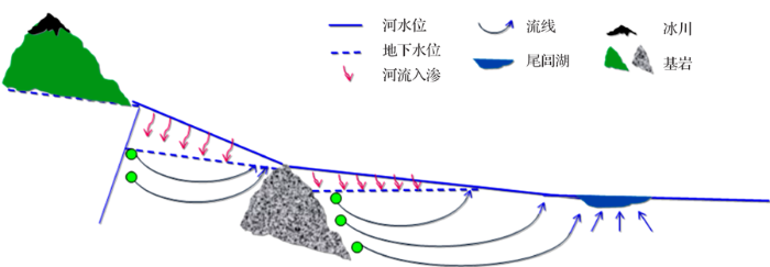
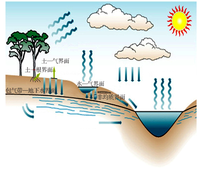
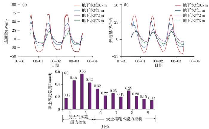