

新一代水文水资源监测卫星SWOT数据特征、应用与展望
收稿日期: 2023-12-27
修回日期: 2024-03-22
网络出版日期: 2024-04-26
基金资助
国家自然科学基金项目(42301501);水利部黄河流域水治理与水安全重点实验室研究基金项目(2022-SYSJJ-04)
Characteristics, Application, and Prospects of a New Generation Hydrological and Water Resources Monitoring Satellite: SWOT
Received date: 2023-12-27
Revised date: 2024-03-22
Online published: 2024-04-26
Supported by
the National Natural Science Foundation of China(42301501);The Research Fund of Key Laboratory of Water Management and Water Security for Yellow River Basin, Ministry of Water Resources(2022-SYSJJ-04)
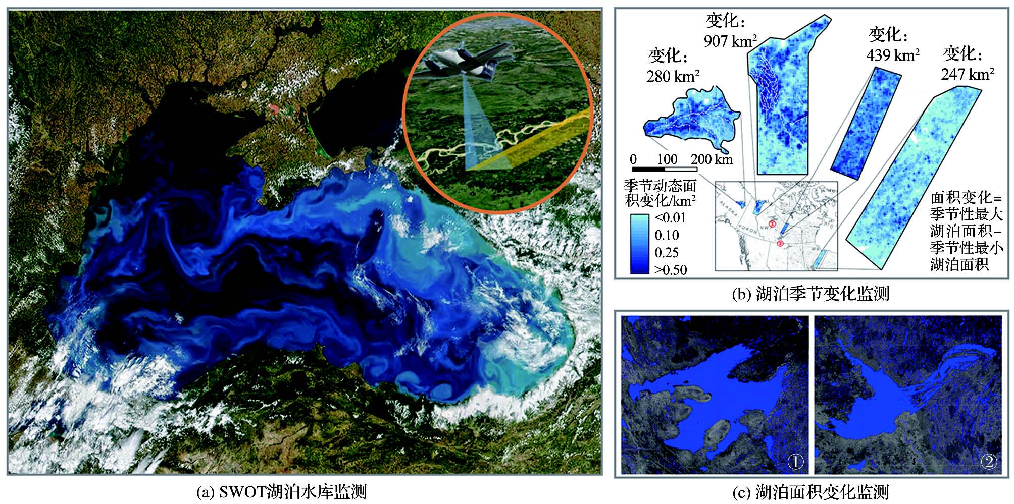
水文水资源监测是对地观测系统的重要任务之一,是支撑新时代水利高质量发展、满足“三水”共治需求和践行“十六字”治水策略的直接有效途径,而卫星遥感技术提供了一种大范围、快速和高精度的数据获取渠道。但是现有卫星遥感在水文水资源应用上存在多星同步观测难、应急响应能力差和易受天气影响等问题,因此美国国家航空航天局于2022年12月发射了地表水和海洋地形卫星(SWOT),这是全球第一颗通过多传感器协同观测全球陆地和海洋水资源的卫星,预期将极大提升水文水资源监测的时空分辨率和精度。系统梳理了水文水资源监测卫星发展现状、应用和技术难点等概况,并分析了SWOT卫星的参数、科学任务、算法流程和应用产品等内容,对我国后续卫星设计规划和数据处理关键技术有一定的参考价值。
关键词: 水资源; 水文学; 卫星遥感; 卫星测高; 地表水和海洋地形卫星(SWOT)任务
么嘉棋 , 常奂宇 , 王梦然 , 陈敏 , 莫凡 , 徐南 , 温振 , 曹永强 . 新一代水文水资源监测卫星SWOT数据特征、应用与展望[J]. 地球科学进展, 2024 , 39(4) : 374 -390 . DOI: 10.11867/j.issn.1001-8166.2024.027
Hydrological and water resource monitoring are pivotal components of Earth observation systems, crucial for supporting the high-quality development of water conservancy in the modern era, fulfilling the requirements of “three water” co-governance, and implementing the “sixteen words” water-control strategy. Satellite remote sensing offers a scalable, rapid, and high-precision data acquisition pathway. Nonetheless, challenges persist in the application of existing satellite remote sensing in hydrology and water resources, including difficulties in achieving multi-satellite synchronous observation, limited emergency response capability, and susceptibility to adverse weather conditions. In December 2022, NASA launched the Surface Water and Ocean Topography (SWOT) satellite, the first satellite in the world designed to observe global land and ocean water resources through multisensor collaboration. This groundbreaking satellite greatly improves the spatial and temporal resolution and accuracy of hydrology and water resource monitoring. This study systematically reviews the development status, applications, and technical challenges of hydrological and water resource monitoring satellites. It also analyzes the satellite parameters, scientific tasks, algorithm flow, and application products of SWOT, providing a valuable reference for future satellite design planning and key data processing technologies, especially in China.
| 1 | ZENG Ziyue, XU Jijun, WANG Yongqiang. Advances in flood risk identification and dynamic modelling based on remote sensing spatial information[J]. Advances in Water Science, 2020, 31(3): 463-472. |
| 1 | 曾子悦, 许继军, 王永强. 基于遥感空间信息的洪水风险识别与动态模拟研究进展[J]. 水科学进展, 2020, 31(3): 463-472. |
| 2 | WANG Zilong, SUN Changhong, JIANG Qiuxiang, et al. Analysis of spatiotemporal variation characteristics of groundwater storage and their influencing factors in three provinces of Northeast China[J]. Advances in Water Science, 2023, 34(3): 360-373. |
| 2 | 王子龙, 孙昌鸿, 姜秋香, 等. 中国东北三省地下水储量时空变化特征及其影响因素分析[J]. 水科学进展, 2023, 34(3): 360-373. |
| 3 | XIONG Lihua, LIU Chengkai, CHEN Shilei, et al. Review of post-processing research for remote-sensing precipitation products[J]. Advances in Water Science, 2021, 32(4): 627-637. |
| 3 | 熊立华, 刘成凯, 陈石磊, 等. 遥感降水资料后处理研究综述[J]. 水科学进展, 2021, 32(4): 627-637. |
| 4 | 中华人民共和国国家发展和改革委员会. “十四五”水安全保障规划[Z]. 2000. [2024-01-12]. https://www.ndrc.gov.cn/xxgk/zcfb/ghwb. |
| 5 | 水利部水文水资源监测预报中心. “十四五”智慧水利建设规划[Z]. 2021. [2024-01-12]. http://xxzx.mwr.gov.cn/. |
| 6 | 中华人民共和国水利部. 《“十四五”水利科技创新规划》 [Z]. 2022. [2024-01-12]. http://gjkj.mwr.gov.cn/slkj1/zcfg_1/202201. |
| 7 | LI Huan, WAN Wei, JI Rui, et al. Inspects and prospects of satellite remote sensing monitoring ability for land surface water in China[J]. National Remote Sensing Bulletin, 2023, 27(7): 1 554-1 573. |
| 7 | 李欢, 万玮, 冀锐, 等. 中国卫星遥感地表水资源监测能力分析与展望[J]. 遥感学报, 2023, 27(7): 1 554-1 573. |
| 8 | JIN Jianwen, LI Guoyuan, SUN Wei, et al. Application status and prospect on water resources investigation and monitoring by satellite remote sensing[J]. Bulletin of Surveying and Mapping, 2020(5): 7-10. |
| 8 | 金建文, 李国元, 孙伟, 等. 卫星遥感水资源调查监测应用现状及展望[J]. 测绘通报, 2020(5): 7-10. |
| 9 | YAO Jiaqi, CHEN Jiyi, CHEN Yun, et al. Cloud detection of remote sensing images based on deep learning and condition random field[J]. Science of Surveying and Mapping, 2019, 44(12): 121-127. |
| 9 | 么嘉棋, 陈继溢, 陈赟, 等. 联合深度学习和条件随机场的遥感影像云检测[J]. 测绘科学, 2019, 44(12): 121-127. |
| 10 | LI Guoyuan, GAO Xiaoming, CHEN Jiyi, et al. Data quality analysis of ZY-3 02 satellite laser altimeter[J]. Journal of Remote Sensing, 2019, 23(6): 1 159-1 166. |
| 10 | 李国元, 高小明, 陈继溢, 等. 资源三号02星激光测高数据质量分析[J]. 遥感学报, 2019, 23(6): 1 159-1 166. |
| 11 | TANG Guoqiang, LONG Di, WAN Wei, et al. An overview and outlook of global water remote sensing technology and applications[J]. Scientia Sinica Technologica, 2015, 45(10): 1 013-1 023. |
| 11 | 唐国强, 龙笛, 万玮, 等. 全球水遥感技术及其应用研究的综述与展望[J]. 中国科学:技术科学, 2015, 45(10): 1 013-1 023. |
| 12 | Editorial Department of Water Conservancy Informatization.The State Council Development Research Center investigates high-scoring water conservancy projects[J]. Water Resources Informatization, 2014(3): 13. |
| 12 | 《水利信息化》编辑部. 国务院发展研究中心调研高分水利项目[J]. 水利信息化, 2014(3): 13. |
| 13 | CHEN Deqing, MA Jianwei, CUI Qian. Design and development of water conservancy application and demonstration application system of Gaofen-3 satellite[J]. Satellite Application, 2018(6): 22-27. |
| 13 | 陈德清, 马建威, 崔倩. 高分三号卫星水利应用及示范应用系统设计开发[J]. 卫星应用, 2018(6): 22-27. |
| 14 | WU Bingfang, ZHU Weiwei, ZENG Hongwei, et al. Watershed remote sensing: definition and prospective[J]. Advances in Water Science, 2020, 31(5): 654-673. |
| 14 | 吴炳方, 朱伟伟, 曾红伟, 等. 流域遥感: 内涵与挑战[J]. 水科学进展, 2020, 31(5): 654-673. |
| 15 | GAO H L, BIRKETT C, LETTENMAIER D P. Global monitoring of large reservoir storage from satellite remote sensing[J]. Water Resources Research, 2012, 48(9). DOI:10.1029/2012WR012063 . |
| 16 | YAO J Q, SUN S Y, ZHAI H R, et al. Dynamic monitoring of the largest reservoir in North China based on multi-source satellite remote sensing from 2013 to 2022: water area, water level, water storage and water quality[J]. Ecological Indicators, 2022, 144. DOI:10.1016/j.ecolind.2022.109470 . |
| 17 | LONG Di, LI Xueying, LI Xingdong,et al.Remote sensing retrieval of water storage changes and underlying climatic mechanisms over the Tibetan Plateau during 2000—2020[J]. Advances in Water Science,2022, 33(3): 375-389. |
| 17 | 龙笛, 李雪莹, 李兴东, 等. 遥感反演2000—2020年青藏高原水储量变化及其驱动机制[J]. 水科学进展,2022, 33(3): 375-389. |
| 18 | LI Ziyang, DAI Jiqun, HUANG Dui,et al. Application and prospects of satellite remote sensing monitoring technology in water conservancy projects[J]. Advances in Water Science, 2023, 34(5): 798-811. |
| 18 | 李子阳, 戴济群, 黄对, 等. 水利工程卫星遥感监测技术应用与展望 [J]. 水科学进展, 2023, 34(5): 798-811. |
| 19 | ZHENG Xuedong. Application of spatial information technology in water conservancy industry: retrospect and prospect[J]. Journal of Yangtze River Scientific Research Institute, 2021, 38(10): 167-173. |
| 19 | 郑学东. 空间信息技术在水利行业的应用回顾与展望[J]. 长江科学院院报, 2021, 38(10): 167-173. |
| 20 | LONG Di, YANG Wenting, SUN Zhangli, et al.Gravity satellite inversion and watershed water balance of groundwater reserves in Haihe Plain[J]. Journal of Hydraulic Engineering, 2023, 54(3): 255-267. |
| 20 | 龙笛, 杨文婷, 孙章丽, 等. 海河平原地下水储量变化的重力卫星反演和流域水量平衡 [J]. 水利学报, 2023, 54(3): 255-267. |
| 21 | PEKEL J F, COTTAM A, GORELICK N, et al. High-resolution mapping of global surface water and its long-term changes[J]. Nature, 2016, 540: 418-422. |
| 22 | TELLMAN B, SULLIVAN J A, KUHN C, et al. Satellite imaging reveals increased proportion of population exposed to floods[J]. Nature, 2021, 596: 80-86. |
| 23 | WANG S L, LI J S, ZHANG W Z, et al. A dataset of remote-sensed Forel-Ule Index for global inland waters during 2000-2018[J]. Scientific Data, 2021, 8. DOI:10.6084/mq.figshare.13257218 . |
| 24 | GUO L, ZHENG H, WU Y, et al. An integrated dataset of daily lake surface water temperature over Tibetan Plateau [J]. Earth System Science Data Discussions, 2021, 2021: 1-15. |
| 25 | KAO H Y, LAGERLOEF G, LEE T, et al. Assessment of Aquarius sea surface salinity[J]. Remote Sensing, 2018, 10(9). DOI:10.3390/rs10091341 . |
| 26 | HORI M, MURAKAMI H, MIYAZAKI R, et al. GCOM-C data validation plan for land, atmosphere, ocean, and cryosphere [J]. Transactions of the Japan Society for Aeronautical and Space Sciences, Aerospace Technology Japan, 2018, 16(3): 218-223. |
| 27 | XU N, ZHENG H Y, MA Y, et al. Global estimation and assessment of monthly lake/reservoir water level changes using ICESat-2 ATL13 products[J]. Remote Sensing, 2021, 13(14).DOI:10.3390/rs13142744 . |
| 28 | SAVE H, BETTADPUR S, TAPLEY B D. High-resolution CSR grace RL05 mascons[J]. Journal of Geophysical Research: Solid Earth, 2016, 121(10): 7 547-7 569. |
| 29 | ZHANG Xiaoning, WEN Qi, WANG Wei. UAV remote sensing monitoring and evaluation of “July 20” torrential rain disaster in Zhengzhou, Henan Province[J]. Disaster Reduction in China, 2021(23): 12-13. |
| 29 | 张晓宁, 温奇, 王薇. 河南郑州“7·20”特大暴雨灾害无人机遥感监测评估[J]. 中国减灾, 2021(23): 12-13. |
| 30 | ZHANG Yanjun, LUO Lan, ZHANG Guo, et al. System conception of small satellite constellation for water sector[J]. China Flood & Drought Management, 2022, 32(11): 1-6, 31. |
| 30 | 张艳军, 罗兰, 张过, 等. 水利小卫星星座总体构想[J]. 中国防汛抗旱, 2022, 32(11): 1-6, 31. |
| 31 | HE Yingqing, QI Zhixin, FENG Youbin, et al. Flood disaster monitoring based on the remote sensing image of GF-3 radar: take the “7·20” heavy rainstorm disaster in Zhengzhou as an example[C]// Volume 2 of proceedings of 2021 annual conference of Chinese Hydraulic Engineering Society. Beijing, 2021:333-340. |
| 31 | 何颖清, 齐志新, 冯佑斌, 等. 基于高分三号雷达遥感影像的洪涝灾害监测: 以郑州“7·20”特大暴雨灾害为例[C]// 中国水利学会2021学术年会论文集第二分册. 北京, 2021: 333-340. |
| 32 | CHANG Huanyu, ZHAO Yong, SANG Xuefeng, et al. Research on the coordinated regulation of water resources-food-energy-ecology in Beijing-Tianjin-Hebei region Ⅰ: methods and model[J]. Journal of Hydraulic Engineering, 2022, 53(6): 655-665. |
| 32 | 常奂宇, 赵勇, 桑学锋, 等. 京津冀水资源—粮食—能源—生态协同调控研究Ⅰ: 方法与模型[J]. 水利学报, 2022, 53(6): 655-665. |
| 33 | ZHAO Yong, CHANG Huanyu, SANG Xuefeng, et al. Research on the coordinated regulation of water resources-food-energy-ecology in Beijing-Tianjin-Hebei region Ⅱ: application[J]. Journal of Hydraulic Engineering, 2022, 53(10): 1 251-1 261. |
| 33 | 赵勇, 常奂宇, 桑学锋, 等. 京津冀水资源—粮食—能源—生态协同调控研究Ⅱ: 应用[J]. 水利学报, 2022, 53(10): 1 251-1 261. |
| 34 | ZHOU Xinghua, YANG Lei, XU Yongsheng, et al. The research progress in calibration/validation of interferometric altimeter[J]. Advances in Marine Science, 2020, 38(4): 549-561. |
| 34 | 周兴华, 杨磊, 徐永生, 等. 干涉雷达高度计定标检验进展[J]. 海洋科学进展, 2020, 38(4): 549-561. |
| 35 | MORROW R, FU L L, ARDHUIN F, et al. Global observations of fine-scale ocean surface topography with the Surface Water and Ocean Topography (SWOT) mission[J]. Frontiers in Marine Science, 2019, 6. DOI:10.3389/fmars.2019.00232 . |
| 36 | YU Haotian, LI Guoyuan. Progress of “surface water and ocean topography” satellite[J]. Space International, 2023(1): 32-37. |
| 36 | 俞昊天, 李国元. “地表水和海洋地形” 卫星进展[J]. 国际太空, 2023(1): 32-37. |
| 37 | BIANCAMARIA S, LETTENMAIER D P, PAVELSKY T M. The SWOT mission and its capabilities for land hydrology[J]. Surveys in Geophysics, 2016, 37(2): 307-337. |
| 38 | DOMENEGHETTI A, SCHUMANN G J P, FRASSON R P M, et al. Characterizing water surface elevation under different flow conditions for the upcoming SWOT mission[J]. Journal of Hydrology, 2018, 561: 848-861. |
| 39 | HUFFMAN G J, BOLVIN D T, NELKIN E J, et al. The TRMM Multisatellite Precipitation Analysis (TMPA): quasi-global, multiyear, combined-sensor precipitation estimates at fine scales[J]. Journal of Hydrometeorology, 2007, 8(1): 38-55. |
| 40 | SHI J C, DONG X L, ZHAO T J, et al. The Water Cycle Observation Mission (WCOM): overview[C]// 2016 IEEE International Geoscience and Remote Sensing Symposium (IGARSS). Beijing: IEEE, 2016: 3 430-3 433. |
| 41 | MU Q Z, ZHAO M S, RUNNING S W. Improvements to a MODIS global terrestrial evapotranspiration algorithm[J]. Remote Sensing of Environment, 2011, 115(8): 1 781-1 800. |
| 42 | MIRALLES D G, JIMéNEZ C, JUNG M, et al. The WACMOS-ET project-Part 2: evaluation of global terrestrial evaporation data sets[J]. Hydrology and Earth System Sciences, 2016, 20(2): 823-842. |
| 43 | WU B F, ZHU W W, YAN N N, et al. Regional actual evapotranspiration estimation with land and meteorological variables derived from multi-source satellite data[J]. Remote Sensing, 2020, 12(2). DOI:10.3390/rs12020332 . |
| 44 | WU B F, YAN N N, XIONG J, et al. Validation of ETWatch using field measurements at diverse landscapes: a case study in Hai Basin of China[J]. Journal of Hydrology, 2012, 436/437: 67-80. |
| 45 | ENTEKHABI D, NJOKU E, O’NEILL P, et al. The Soil Moisture Active/Passive Mission (SMAP)[C]// IGARSS 2008-2008 IEEE International Geoscience and Remote Sensing Symposium. Boston, MA, USA: IEEE, 2008. |
| 46 | YEH P J F, SWENSON S C, FAMIGLIETTI J S, et al. Remote sensing of groundwater storage changes in Illinois using the Gravity Recovery and Climate Experiment (GRACE) [J]. Water Resources Research, 2006, 42(12). DOI:10.1029/2006WR005374 . |
| 47 | MA Yi, ZHANG Jie, ZHANG Jingyu, et al. Progress in shallow water depth mapping from optical remote sensing[J]. Advances in Marine Science, 2018, 36(3): 331-351. |
| 47 | 马毅, 张杰, 张靖宇, 等. 浅海水深光学遥感研究进展[J]. 海洋科学进展, 2018, 36(3): 331-351. |
| 48 | FLUET-CHOUINARD E, LEHNER B, REBELO L M, et al. Development of a global inundation map at high spatial resolution from topographic downscaling of coarse-scale remote sensing data[J]. Remote Sensing of Environment, 2015, 158: 348-361. |
| 49 | KLEIN I, GESSNER U, DIETZ A J, et al. Global WaterPack-A 250 m resolution dataset revealing the daily dynamics of global inland water bodies[J]. Remote Sensing of Environment, 2017, 198: 345-362. |
| 50 | GHULAM A, QIN Q M, TEYIP T, et al. Modified Perpendicular Drought Index (MPDI): a real-time drought monitoring method[J]. ISPRS Journal of Photogrammetry and Remote Sensing, 2007, 62(2): 150-164. |
| 51 | MOU Lingli, WU Bingfang, YAN Nana, et al.Remote sensing monitoring study of agricultural drought situation based on vegetation and temperature conditions [J].World Sci-Tech R & D, 2006, 28(3): 26-31. |
| 51 | 牟伶俐,吴炳方,闫娜娜,等.基于植被与温度条件的农业旱情遥感监测研究[J].世界科技研究与发展, 2006, 28(3): 26-31. |
| 52 | JIANG Xingwei, SONG Qingtao. Satellite microwave measurements of the global oceans and future missions[J]. Science & Technology Review, 2010, 28(3): 105-111. |
| 52 | 蒋兴伟, 宋清涛. 海洋卫星微波遥感技术发展现状与展望[J]. 科技导报, 2010, 28(3): 105-111. |
| 53 | LEBEN R R, BORN G H, ENGEBRETH B R. Operational altimeter data processing for mesoscale monitoring[J]. Marine Geodesy, 2002, 25(1/2): 3-18. |
| 54 | JIANG Xingwei, LIN Mingsen, SONG Qingtao. Active and passive microwave remote sensing technology of the HY-2A ocean satellite mission[J]. Engineering Sciences, 2013, 15(7): 4-11. |
| 54 | 蒋兴伟, 林明森, 宋清涛. 海洋二号卫星主被动微波遥感探测技术研究[J]. 中国工程科学, 2013, 15(7): 4-11. |
| 55 | LIU Zhen, HU Lianbo, HE Mingxia. Retrieval of shallow water depth and optical parameters around islands and reefs in the South China Sea by EO-1/hypeion data[J]. Periodical of Ocean University of China, 2014, 44(5): 101-108. |
| 55 | 刘振, 胡连波, 贺明霞. 卫星高光谱数据反演南沙岛礁区海域浅海水深和光学参数[J]. 中国海洋大学学报(自然科学版), 2014, 44(5): 101-108. |
| 56 | HUANG Motao, ZHAI Gunjun, OUYANG Yongzhong, et al.Study of submarine topography by using satellite height survey data[C]// China Association for Science and Technology, Jilin Provincial People’s Government. In the new century, new opportunities and new challenges—knowledge innovation and high-tech industry development (volume 1). Tianjin: Survey Laboratory of Tianjin Institute of Marine Surveying and Mapping, 2001. |
| 56 | 黄谟涛,翟国君,欧阳永忠,等.利用卫星测高资料反演海底地形研究[C]// 中国科学技术协会,吉林省人民政府.新世纪 新机遇 新挑战——知识创新和高新技术产业发展(上册).天津:天津海洋测绘研究所测量研究室, 2001. |
| 57 | BECKER J J, SANDWELL D T, SMITH W H F, et al. Global bathymetry and elevation data at 30 arc seconds resolution: SRTM30_PLUS[J]. Marine Geodesy, 2009, 32(4): 355-371. |
| 58 | WILKIN J L, BOWEN M M, EMERY W J. Mapping mesoscale currents by optimal interpolation of satellite radiometer and altimeter data[J]. Ocean Dynamics, 2002, 52(3): 95-103. |
| 59 | BONJEAN F, LAGERLOEF G S E. Diagnostic model and analysis of the surface currents in the tropical Pacific Ocean[J]. Journal of Physical Oceanography, 2002, 32(10): 2 938-2 954. |
| 60 | WU Guiping, LIU Yuanbo. Satellite retrieval of important ocean hydrological parameters: an overview[J]. Advances in Water Science, 2016, 27(1): 139-151. |
| 60 | 吴桂平, 刘元波. 海洋重要水文参数的卫星遥感反演研究综述[J]. 水科学进展, 2016, 27(1): 139-151. |
| 61 | ANDREADIS K M, CLARK E A, LETTENMAIER D P, et al. Prospects for river discharge and depth estimation through assimilation of swath‐altimetry into a raster‐based hydrodynamics model [J]. Geophysical Research Letters, 2007, 34(10). DOI:10.1029/2007GL029721 . |
| 62 | DURAND M, ANDREADIS K M, ALSDORF D E, et al. Estimation of bathymetric depth and slope from data assimilation of swath altimetry into a hydrodynamic model [J]. Geophysical Research Letters, 2008, 35(20). DOI:10.1029/2008GL034150 . |
| 63 | BIANCAMARIA S, DURAND M, ANDREADIS K M, et al. Assimilation of virtual wide swath altimetry to improve Arctic River modeling[J]. Remote Sensing of Environment, 2011, 115(2): 373-381. |
| 64 | YOON Y, DURAND M, MERRY C J, et al. Estimating river bathymetry from data assimilation of synthetic SWOT measurements[J]. Journal of Hydrology, 2012, 464/465: 363-375. |
| 65 | YOON Y, DURAND M, MERRY C J, et al. Improving temporal coverage of the SWOT mission using spatiotemporal Kriging[J]. IEEE Journal of Selected Topics in Applied Earth Observations and Remote Sensing, 2013, 6(3): 1 719-1 729. |
| 66 | ANDREADIS K M, SCHUMANN G J P. Estimating the impact of satellite observations on the predictability of large-scale hydraulic models[J]. Advances in Water Resources, 2014, 73: 44-54. |
| 67 | PEDINOTTI V, BOONE A, RICCI S, et al. Assimilation of satellite data to optimize large-scale hydrological model parameters: a case study for the SWOT mission[J]. Hydrology and Earth System Sciences, 2014, 18(11): 4 485-4 507. |
| 68 | PAIVA R C D, DURAND M T, HOSSAIN F. Spatiotemporal interpolation of discharge across a river network by using synthetic SWOT satellite data[J]. Water Resources Research, 2015, 51(1): 430-449. |
| 69 | MUNIER S, POLEBISTKI A, BROWN C, et al. SWOT data assimilation for operational reservoir management on the upper Niger River Basin[J]. Water Resources Research, 2015, 51(1): 554-575. |
| 70 | TUOZZOLO S, LIND G, OVERSTREET B, et al. Estimating river discharge with swath altimetry: a proof of concept using AirSWOT observations[J]. Geophysical Research Letters, 2019, 46(3): 1 459-1 466. |
| 71 | LARNIER K, MONNIER J, GARAMBOIS P A, et al. River discharge and bathymetry estimation from SWOT altimetry measurements[J]. Inverse Problems in Science and Engineering, 2021, 29(6): 759-789. |
| 72 | ALTENAU E H, PAVELSKY T M, DURAND M T, et al. The Surface Water and Ocean Topography (SWOT) Mission River Database (SWORD): a global river network for satellite data products [J]. Water Resources Research, 2021, 57(7). DOI:10.1029/2021WR030054 . |
| 73 | CHEN T, SONG C Q, KE L H, et al. Estimating seasonal water budgets in global lakes by using multi-source remote sensing measurements[J]. Journal of Hydrology, 2021, 593. DOI: 10.1016/j.jhydrol.2020.125781 . |
| 74 | YANG K H, YAO F F, WANG J D, et al. Recent dynamics of alpine lakes on the endorheic Changtang Plateau from multi-mission satellite data[J]. Journal of Hydrology, 2017, 552: 633-645. |
| 75 | YAO F F, WANG J D, WANG C, et al. Constructing long-term high-frequency time series of global lake and reservoir areas using Landsat imagery[J]. Remote Sensing of Environment, 2019, 232. DOI: 10.1016/j.rse.2019.111210 . |
| 76 | ZHANG G Q, CHEN W F, XIE H J. Tibetan Plateau’s lake level and volume changes from NASA’s ICESat/ICESat-2 and landsat missions[J]. Geophysical Research Letters, 2019, 46(22): 13 107-13 118. |
| 77 | YUE H, LI Y, QIAN J X, et al. A new accuracy evaluation method for water body extraction[J]. International Journal of Remote Sensing, 2020, 41(19): 7 311-7 342. |
| 78 | PAPA F, PRIGENT C, ROSSOW W B. Monitoring flood and discharge variations in the large Siberian Rivers from a multi-satellite technique[J]. Surveys in Geophysics, 2008, 29(4): 297-317. |
| 79 | SZOMBARA S, LEWI?SKA P, ??D?O A, et al. Analyses of the Pr?dnik riverbed shape based on archival and contemporary data sets—old maps, LiDAR, DTMs, orthophotomaps and cross-sectional profile measurements [J]. Remote Sensing, 2020, 12(14). DOI: 10.3390/rs12142208 . |
| 80 | CARMELA C, MICHAEL N, NICOLINA P M, et al. Monitoring the morphological evolution of a reach of the Italian Po River using multispectral satellite imagery and stage data[J]. Geocarto International, 2022, 37(25): 8 579-8 601. |
| 81 | WU Q H, KE L H, WANG J D, et al. Satellites reveal hotspots of global river extent change[J]. Nature Communications, 2023, 14. DOI:10.1038/s41467-023-37061-3 . |
| 82 | JIA H C, CHEN F, PAN D H, et al. Flood risk management in the Yangtze River Basin—comparison of 1998 and 2020 events[J]. International Journal of Disaster Risk Reduction, 2022, 68. DOI: 10.1016/j.ijdrr.2021.102724 . |
| 83 | EL-RAWY M, ELSADEK W M, de SMEDT F. Flood hazard assessment and mitigation using a multi-criteria approach in the Sinai Peninsula, Egypt[J]. Natural Hazards, 2023, 115(1): 215-236. |
| 84 | CAO Y Q, WANG M R, YAO J Q, et al. Stereoscopic monitoring methods for flood disasters based on ICESat-2 and sentinel-2 data[J]. Remote Sensing, 2023, 15(12). DOI:10.3390/rs15123015 . |
| 85 | LABORATORY J P. Fine-scale transport of heat & carbon [Z]. 2023. [2024-01-12]. https://swot.jpl.nasa.gov/science/oceanography/. |
| 86 | SONG T, HAN N S, ZHU Y H, et al. Application of deep learning technique to the sea surface height prediction in the South China Sea[J]. Acta Oceanologica Sinica, 2021, 40(7): 68-76. |
| 87 | NIAN R, CAI Y, ZHANG Z G, et al. The identification and prediction of mesoscale eddy variation via memory in memory with scheduled sampling for sea level anomaly[J]. Frontiers in Marine Science, 2021, 8. DOI:10.3389/fmars.2021.753942 . |
| 88 | LABORATORY J P. Altimetry: past, present and future [Z]. 2014. [2024-01-12]. https://swot.jpl.nasa.gov/resources/148/altimetry-past-present-and-future/. |
| 89 | LABORATORY J P. SWOT launched successfully on December 16, 2022[Z]. 2023. [2024-01-12]. https://eospso.nasa.gov/missions/surface-water-ocean-topography. |
/
| 〈 |
|
〉 |
