青藏高原水文模拟的现状及未来
王磊, 李秀萍, 周璟, 刘文彬, 阳坤
中国科学院青藏高原研究所, 北京 100101

作者简介:王磊(1981-),男,新疆乌鲁木齐人,研究员,主要从事分布式陆面水文模型的开发及其在综合水资源管理中的应用等研究.E-mail:wanglei@itpcas.ac.cn

摘要

介绍了青藏高原水文模拟的研究现状和发展趋势。水文模拟是研究水文过程的主要手段,可为流域水资源管理及防灾减灾提供理论和决策支持。国际上第一代水文模型为“集总式”,第二代水文模型为“分布式”,但它们大都以描述降水—产流的水分输移为主(“水圈”),未仔细考虑陆—气水热交换中植被的调节作用(“生物圈—大气圈”)。近10年来,在气候变化的背景下,随着大气科学以及生态学的蓬勃发展,分布式水文模型开始描述生物圈—大气圈相互作用;[JP2]通过改进陆—气间的水热交换过程以及植被的生理过程,实现了对流域水圈—生物圈—大气圈的综合模拟。然而,针对显著受冰冻圈过程影响的青藏高原,需要深入研究冰冻圈与其他圈层(水圈/生物圈/大气圈)的相互作用机理,并实现其在水文模拟中的参数化,以提升区域水资源和水灾害的预测能力。

关键词: 水文过程; 多圈层水文模型; 水和能量平衡; 冰冻圈; 陆面过程
中图分类号:P334 文献标志码:A 文章编号:1001-8166(2014)06-0674-09
Hydrological modelling over the Tibetan Plateau: Current status and Perspective
Wang Lei, Li Xiuping, Zhou Jing, Liu Wenbin, Yang Kun
Institute of Tibetan Plateau Research, Chinese Academy of Sciences, Beijing 100101, China
Abstract

This paper describes the current status and perspective for the hydrological modelling over the Tibetan Plateau (TP). Hydrological models, as primary tools to study hydrological processes, can provide theoretical and decision support for water resources management as well as disaster prevention and mitigation in river basins. As is known, the first-generation hydrological models are “lumped”, and the second-generation hydrological models are “distributed”. However, most of the above models mainly describe the “precipitation-to runoff” water transport processes (“hydrosphere”) without carefully addressing the special role of vegetation in the water and energy exchanges in the landatmosphere interactions (“biosphere-atmosphere”). Over the past decade, in the context of climate change, with the vibrant developments of atmospheric science and ecology, distributed hydrological models began to describe the biosphereatmosphere interactions by improving the water and energy cycle formulations between the land and atmosphere, as well as enhancing the descriptions of physiological processes of vegetation. Up to now, a comprehensive description of hydrosphere-biosphere-atmosphere interactions in river basins has been realized by the hydrological community. However, regarding TP with a large portion of cryosphere land cover, the detailed cryospheric processes are of essence to be further considered in the multi-sphere hydrological modeling over TP. This will largely contribute to studies of the interaction mechanism among the cryosphere and other spheres (hydrosphere /biosphere /atmosphere), and thus improve the predictive ability of the region’s water resources and water-related disasters.

Keyword: Hydrological process; Multi-sphere hydrological model; Water and energy balance; Cyosphere; Land surface process.
1 引 言

青藏高原广泛分布有冰雪、湖泊、多年冻土和季节冻土。在全球变暖背景下,由于冰冻圈对温度变化异常敏感[ 1, 2],青藏高原地表环境已经发生了深刻的变化,表现为雪线上升、冰川退缩、冻土退化以及湖泊面积急剧变化[ 2, 3, 4, 5]。1961—2006年间,中国年平均冰川融水径流量为62.3 km3,2001—2006年平均值则为79.4 km3,青藏高原由于多年冻土退化每年释放的水量达到5-11 km3,冰川和冻土的变化已引起了高原水资源时空分布和水循环过程的变化[ 6]。冰川退缩同时引发下游湖泊扩张,并淹没了周边草场,使得草甸和沼泽湿地面积减少,威胁到生态系统[ 7]。高原地表环境的深刻变化给我国西北干旱区绿洲经济的长期发展带来了很大的不确定性。

对于青藏高原这样的复杂巨系统,构建包括冰冻圈、水圈、生物圈、大气圈等各个圈层的集成模型,通过模型采用数值模拟的方法可以说是再现各个圈层内部过程及其相互作用的唯一手段[ 8]。而水循环过程是连接各个圈层的重要纽带,各个圈层通过水循环组成了一个相互作用的整体系统。借助青藏高原多圈层综合水文模拟,可增进对该地区各圈层间水分和能量交换过程的理解,提高对该地区水资源及水灾害的预测能力。

目前,气候模拟系统中对大尺度的冰冻圈下垫面(冰原、海冰、积雪、和冻土等)与大气的相互作用描述较多,但对非极地冰冻圈的描述还比较弱,也比较零散。相对于极地冰冻圈,高海拔冰冻圈具有尺度小、空间变异性大的特点。不可照搬已有的包含大尺度冰冻圈过程的陆面模型,必须提出新的框架,发展适用于高海拔冰冻圈的陆面水文模型。此外,还有大量的其他地表过程模拟,但大多数是针对单要素的模拟,未考虑青藏高原多圈层耦合的特点,例如冰川径流模拟[ 9]、冻土模拟[ 10]、融雪模拟[ 11]、极地有机质土壤水热传输[ 12]和基于流域地形的水文模拟[ 13]等。针对高原的特点,将基于流域地形和能水平衡的陆面水文模拟与各典型冰冻圈要素(冰川/积雪/冻土/湖泊)的过程模拟进行耦合,发展反映各圈层相互作用的集成水文模型,对于理解圈层间水相转换和物质流的强度和区域差异,预测地表环境的变化至关重要[ 14],在当前显得尤为迫切。基于观测资料分析基本物理过程,发展参数化方案和模型,仍然是实现这一目标的必由之路[ 15]

总之,由于青藏高原地表冰冻圈—水圈—生物圈—大气圈的相互作用,其地表水文过程显得异常复杂。目前研究这些复杂过程主要依赖观测和经验模型,亟需通过多学科的交叉融合,发展多圈层水文模型,提升对高原地表水资源和水灾害的模拟和预测能力。

2 水文模型的发展

水文建模是对水循环规律研究和认识的必然结果,是研究水文过程的主要手段,可为流域水资源管理及防灾减灾提供理论和决策支持。国际上第一代水文模型为“集总式”,如美国斯坦福模型[ 16]、水箱模型[ 17]、以及新安江模型[ 18]等,它们合理地描绘了流域降水产流的基本规律,但是这类模型对物理过程予以抽象概化并通常不考虑水循环过程中的物理机制,大都忽略了地形、植被等的空间变化对流域产汇流过程的影响。1969年,Freeze等[ 21]首次提出了分布式水文模型的概念。该类模型考虑了流域的空间变异性,通常利用数理方程计算坡面产流及河道汇流,较完整地描述了流域水文过程。20世纪80年代以后,随着建模思想、水文理论、计算机性能、遥感和3S技术(GIS, RS, GPS)的飞跃发展,涌现出了一批分布式水文模型,例如TOPMODEL[ 22], SHE[ 23, 24] ,VIC[ 25],DHSVM[ 26],the distributed triangulated irregular network model[ 27]和GBHM[ 28, 29]等,并在实际问题中得到了广泛应用。由于分布式水文模型能够考虑水文参数和过程的空间异质性,能够考虑水分在各个离散单元之间的运动和交换,更真实地模拟了实际水循环过程,从而成为水文模型发展的趋势[ 18, 19, 20]。分布式水文模型也存在参数众多,难以率定,需要大量观测数据验证等问题。尽管相比于“集总式”模型其精度没有实质性提高,但模型的物理基础越来越坚实,离现实情况也越来越接近。20世纪90年代后,大尺度水文模型的研究受到关注,从小流域到大流域,再到大陆尺度,模拟的空间越来越大。

进入21世纪后,以解决无观测资料地区水文预测为目的的PUB (Prediction of Ungauged Basin)项目的启动,使水文模型的开发又迎来了一个新的阶段。PUB项目以减少水文预报中的不确定性为核心,汇集水文理论,遥感技术,对地观测等多方面成果,旨在探索水文模拟的新方法,从而解决无资料地区的水文预测问题[ 30]。最近10年来,由于水文气象学、生态水文学、冰冻圈水文学等的兴起,分布式水文模型与多个学科的交叉使得建模的难度越来越高,模拟研究不断深入,分布式模型已经成为研究区域气候变化的水文响应、水资源综合管理等方面的重要工具之一[ 31]

总之,国际上第一代和第二代水文模型大都以描述降水—产流的水分输移为主(“水圈”),未仔细考虑陆—气水热交换中植被的调节作用(“生物圈—大气圈”)。近10年来,在气候变化的背景下,随着大气科学以及生态学的蓬勃发展,分布式水文模型开始描述生物圈—大气圈相互作用;通过改进陆—气的水热交换过程以及植被的生理过程,实现了对流域水圈—生物圈—大气圈的综合模拟(“多圈层水文模型”[ 32, 33, 34, 35])。

3 水文模型在青藏高原的应用

青藏高原是长江、黄河、怒江、澜沧江、雅鲁藏布江、恒河、印度河等亚洲七大江河的发源地,对众多河流的发育具有决定性作用,大气降水、冰雪消融和地下水是主要河流的补给来源。由于青藏高原自然条件艰苦,难以开展常规的实地观测,必须结合数值模拟和全球卫星资料(为模型提供相应的验证资料)来更好地认识高原的冰川—积雪—冻土—河流—湖泊耦合水文过程[ 34]

因历史气象水文等观测多集中在高原东部地区,导致过去基于水文模型对高原径流过程的认识多集中在长江源区和黄河源区。如高红凯等[ 36]在长江源区的冬克玛底河流域采用HBV模型较好的模拟了流域年月径流深,但对日径流的模拟效果要逊于月径流的模拟;SRM (snowmelt-runoff model) 模型在冬克玛底河流域能够较好的模拟融雪径流过程[ 37]。SWAT模型在三江源区也基本能够刻画该地区的水循环过程,并结合GCM气候模式预测了未来径流的变化趋势[ 38, 39],但SWAT模型在日径流模拟方面还存在不足、因而难以准确描述水灾害等极端事件的变化;VIC模型在长江、黄河源区能较好的模拟该区域的地表径流[ 40],但对冻土相关过程的考虑较弱;Lan et al.在黄河源区运用VIC模型评价了气候和土地利用变化对径流的影响[ 41]。尽管在高原东部已有了不少水文模型的成功应用,而在青藏高原中西部地区的水文模拟工作多年来鲜有开展,这在很大程度上归因于水文气象资料的匮乏和传统水文模型对径流观测的过度依赖(它们大多以径流为水文模拟的唯一验证手段并需要较长序列的径流数据)。因而,研究高原中西部地区的水文过程,需要一个能通过地表径流观测、野外实地观测(如能量通量、土壤水分)及卫星观测数据等进行多尺度校准与验证的新一代水文模型。

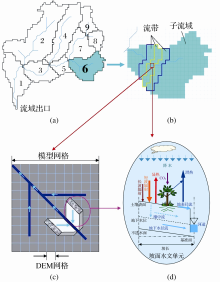
通常,传统水文模型侧重于降雨径流模拟和水分收支,对能量平衡的描述不足,并概念性的描述蒸散发和陆面过程;而陆面模式可物理性的描述蒸散发等过程,并考虑了能量平衡,但对水文过程的考虑较为粗略,不能很好的反映空间异质性[ 42]。二者耦合可以更好的反映陆—气间具有双向反馈的复杂相互关系。新一代水文模型的发展[ 32, 33, 34, 35]逐步采纳相关领域的进展,改进模型的物理机制。例如一维陆面模式(例如:SiB2,the revised simple biosphere model[ 43]或者BATS,biosphere atmosphere transfer scheme[ 44])可物理性的描述土壤—植被—大气之间的水热传输过程,可用来替代水文模型中常用的概念型蒸散发模型。例如,Wang等[ 33]借鉴了SiB2[ 43]的能量平衡和生物物理机制,将其嵌入到基于地形描述坡面产汇流的分布式水文模型GBHM[ 28, 29]中,从而发展了基于能量和水量平衡的分布式水文模型(Water and Energy Budget-based Distributed Hydrological Model,WEB-DHM[ 33, 34, 35])。如图1所示,WEB-DHM模型考虑了微地形影响,既提高了模型的计算精度,也保持了模型的运行效率;另一方面,WEB-DHM耦合了能量平衡过程,除了可用常规径流观测进行模拟验证之外,还可利用水和能量循环的全球卫星观测数据验证和改进模型,这也为多圈层水文模型在第三极地区等缺资料流域的应用提供了可能。目前该模型已经在国内外数十个流域进行了应用,比如:日本Tone上游流域[ 34]、尼泊尔Dudhkoshi流域[ 45]以及黑河上游冰沟小流域[ 46]等,在模拟流域尺度的水分和能量循环方面展示出良好性能。在高原中部的那曲流域[ 47],WEB-DHM成功模拟了流域陆面温度(LST)、土壤含水量和径流,为模型今后在高原的应用提供了很好的借鉴。

图1 多圈层水文模型WEBDHM的总体结构图
(a)子流域划分;(b)遵循等流时线的概念,将子流域进一步划分为若干流段(flow interval);(c)针对每个模型网格,利用子网格参数化计算每个模型网格的坡长和坡角;(d)针对每个模型网格,计算陆—气之间的水、热、CO2交换,从而得到垂向的土壤水分廓线及地表和植被截留,再利用子网格体系在坡面上计算产流(包含地表径流、壤中流、以及地下水径流3部分)。这里,每个流段的产流量是其包含的各网格的总产流,汇流过程则针对全流域的所有流段进行
Fig.1 Overall structure of multi-sphere hydrological model WEB-DHM
(a)Division of sub-basins;(b)Further division of a sub-basin into several flow intervals following the concept of equal stream lines;(c)For each model grid, slope length and slope angle are calculated with the sub-grid parameterization;(d)For each model grid, the exchanges of water, energy, CO2between land and atmosphere are calculated, and thus get the vertical soil moisture profiles as well as the interceptions by canopy and ground. Finally, hillslope runoff (including surface runoff, subsurface flow, and groundwater runoff) is calculated using the sub-grid scheme. Here, the runoff of a flow interval is the total runoff of all model grids within the specified flow interval. Finally, the river routing is carried out for all the flow intervals within the whole basin

4 青藏高原多圈层水文模型的发展

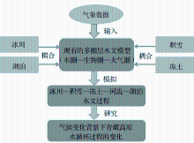
青藏高原同时受季风和西风带影响,孕育了大量的冰川和湖泊。以水的多相态转换为纽带的冰冻圈—水圈—大气圈相互作用,为该地区提供了大量水资源的同时,也为该地区带来了环境的风险与灾害。理解青藏高原的冰雪—湖泊—大气间的水体转换,以及对局地和区域气候的能量和水分反馈,是预测该地区的水文水资源变化以及相应的环境影响的基础。因而,要提升对青藏高原多圈层相互作用机理的认识,必须在现有的多圈层水文模型(WEB-DHM,可描述“水圈—生物圈—大气圈”相互作用)中进一步耦合冰川、积雪、冻土、湖泊等冰冻圈要素的物理过程模块,发展青藏高原多圈层集成水文模型(图2),才能更好地再现青藏高原冰冻圈—水圈—大气圈—生物圈耦合过程,增强对气候变化背景下青藏高原水循环过程变化的理解。下面逐一介绍各类冰冻圈要素的模型发展。

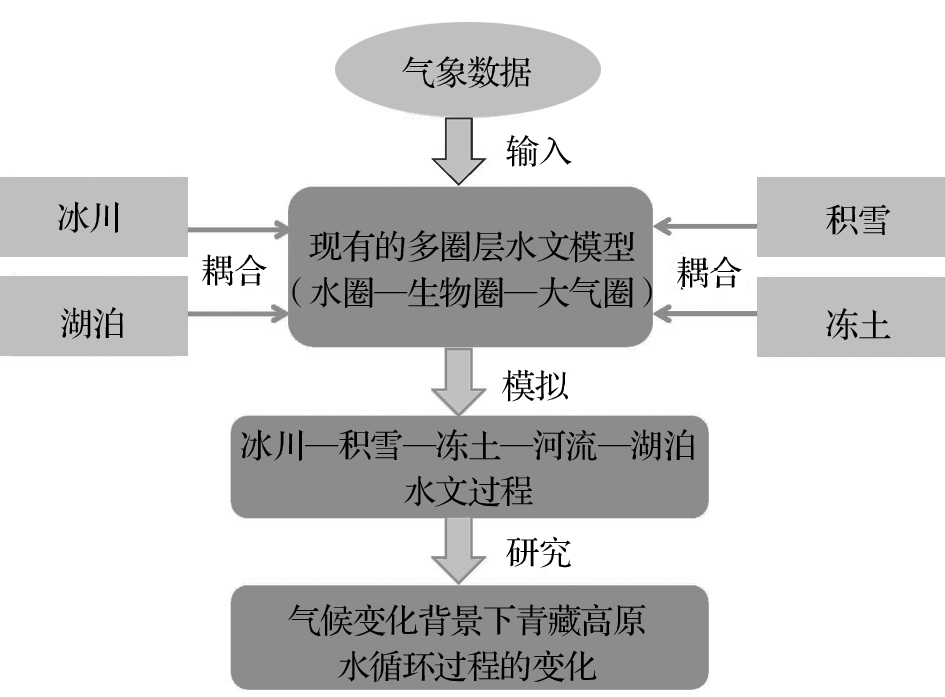
图2 青藏高原多圈层水文模型的发展示意图Fig.2 Schematic diagram of the development of multi-sphere hydrological model for the Tibet Plateau

4.1 冰川消融模型

中国境内的青藏高原有现代冰川36 793条,冰川面积49 873 km2,分别占中国冰川总条数的79.5%和冰川总面积的84%[ 2, 48]。由于冰川对气候变化的敏感性,如何估算冰川消融成为重要的课题。对冰川消融的模拟基于2类模型。一类是基于气象因子的经验统计模型。常用的统计模型是度日因子法。度日因子法由于其简单且输入的参数少而被广泛使用[ 49, 50, 51]。有许多研究在度日因子中还增加了辐射、风速等变量,使得模拟结果好于只基于温度的模拟结果[ 52]。这类模型不是建立在严格的物理基础上,需要进行局部校正。另一类模型是基于能量平衡机制发展起来的模型,具有普适性,但一些理论和技术问题仍待解决[ 53, 54, 55, 56, 57]。尽管如此,基于能量平衡机制的冰雪消融模型近年来发展很快[ 58, 59, 60, 61, 62, 63, 64],也是今后应进一步发展的方向。目前,这种模型与水文模型的耦合已经初步应用于冰川径流和流域径流方面的研究中[ 65, 66]。应用基于能量平衡的冰川模型的一个主要困难是缺乏可靠的降水数据,特别是降水类型(雨、雪)对冰雪水文具有完全不同的影响,需要发展能识别雨雪类型的算法[ 67]。WEB-DHM对于冰川消融模型的耦合,目前主要考虑度日因子法,基于能量平衡机制的冰雪消融模型并在其中加入识别雨雪类型的算法是今后模型发展的主要方向。

4.2 积雪模型

积雪下垫面是一个非常重要的陆面类型,其高反照率特征明显改变地表能量输送,可显著影响天气系统。由于认识到单层积雪模型[ 44, 68]的局限性,中度复杂的多层积雪模型[ 69, 70, 71](通常2~5层)自20世纪90年代以来逐渐涌现并得到了长足的发展。由于采用多雪层结构,它们可较好地考虑积雪内部物理过程,比如:考虑雪花形态的破坏而引起的密度变化及由于压实过程而引起的密度变化等[ 71]。目前国际上有不少这类多层积雪模型,比如:JULES[ 72],CLASS[ 73],the Community Land-surface Model (CLM)[ 74],WEB-DHM-S[ 11]和Snow 17[ 75]。另外,还有一类更复杂的积雪模型注重于描述积雪的微结构和物理性质,比如:SNTHERM[ 76],Crocus[ 77, 78]以及SNOWPACK[ 79] 等。

水文模拟中比较常用的是中度复杂的多层积雪模型。这里以已成功发展的分布式积雪模型WEB-DHM-S[ 11](the WEB-DHM with improved snow physics)为例:它在雪深小于5 cm时保留WEB-DHM的单层积雪模块;而在雪深大于5 cm时、则耦合孙菽芬等[ 70, 71]开发的三层积雪模型,其用焓代替温度作为预报量、克服了相变时直接预报温度时造成的计算误差、有效地预报了相变过程。WEB-DHM-S积雪反照率的参数化则借鉴BATS陆面模型、考虑了反照率随积雪时间和太阳入射角的变化[ 80, 81]

4.3 冻土模型

土壤水的冻结与融化,不仅影响着土壤的热力学和水力学性质,也对区域陆面—大气能水交换过程有着重要的影响。比如:冻土区活动层冻融过程对相变热的消耗形成了对地表温度的负反馈作用,降低了地气温差,致使多年冻土区的感热呈现下降趋势。因此,通过监测,在阐明冻土水热过程及其物理机制的基础上,构建适宜于高寒区的冻土模型,才能提高青藏高原冻土水文过程的模拟和预测水平。WEB-DHM根据实测地表辐射通量和上层土壤水分(5cm,10cm和20cm),优化了地表参数和土壤水力方程中的参数,并根据实测土壤温度(5cm)校准了冻土参数同时根据实测径流校准了其他土壤水力参数,从而在模型中加入了冻土模拟[ 46]。目前,冻土模拟已有较明显的进展,已在黑河上游的冰沟小流域等得到成功应用[ 46, 82, 83],但仍然存在几个关键问题有待解决:①巨大相变热的释放作为控制方程中的源汇项存在,易导致方程数值求解的不稳定;②冻结状态下土壤水力和热力性质如何改变;③在高寒区,草甸层下由于有机质的长期积累,显著改变了土壤的性质[ 84, 85, 86],这一有机土层对冻土的影响如何在模拟中体现。

4.4 湖泊模型

青藏高原的湖泊总面积达45 000 km2,约占全国湖泊总面积的一半[ 87]。内流湖约占高原湖泊总面积的90%,多分布在海拔4 000~5 000 m的范围。由于缺乏长期的野外定位监测系统,很少有研究探讨湖泊—大气之间水热交换过程。湖泊模型发展起步于20世纪60年代,经历了从单层、单成分、零维的简单模型到多层、多成分、三维的复杂模型的发展历程。按空间属性划分,可分为一维 (如FLake[ 88])、二维 (如CE-QUAL-W2[ 89])、三维 (如EFDC[ 90])。关于研究湖泊的水热传输模型,早在1985年,Henderson-Sellers[ 91]提出了最初的涡旋扩散模型;Hostetler和Bartlein[ 92]提出了更接近物理过程的涡旋扩散模型,用来模拟湖泊温度及其蒸发的季节性变化[ 93]。2008年,孙菽芬等[ 94]发展了一个在低海拔已经验证的湖泊冻融模型,但在高海拔地区由于空气密度和湖水盐分的变化,该模型的适用性有待检验。2010年,Bowling等[ 95]在VIC模型的框架内开发了包含湖泊和湿地的算法,包含了永久性水体和季节性洪水在每个网格点上的相互作用;该算法可模拟湖水温度、净辐射、冰冻结/解冻以及产流,被广泛用于研究高纬度地区湖泊的水热模拟。然而,由于青藏高原湖泊的特殊性,该模型的适用性也有待进一步检验。WEB-DHM对于湖泊模型的耦合目前还处于发展阶段,Flake以及可以灵活处理边界的EFDC水动力模块是今后耦合中需主要考虑的湖泊模型。

5 结论与展望

青藏高原冰冻圈变化是全球变化的研究热点,但目前水文模型对冰冻圈变化的模拟能力不强。为了改进该区域对水资源及水灾害的模拟和预测能力,迫切需要选择若干重点研究区域,兼顾高原西部和周边地区湖泊和冰川的多样性,通过强化野外综合观测(比如:典型冰雪—大气界面和湖泊—大气界面能量通量等)和室内分析(比如:土壤水热性质测量等),研究该地区的冰雪消融、土壤冻融和湖泊表面水热传输过程,并发展相关下垫面过程模型,并集成到现有的多圈层水文模型中,从而实现冰川—积雪—冻土—河流—湖泊的综合水文过程模拟,以更好地认识青藏高原多圈层相互作用机理,提升对区域水资源和水灾害的模拟和预测能力。

由于青藏高原地区观测资料缺乏,以及其耦合多圈层相互作用的特点,使得多圈层水文模型成为研究青藏高原水循环过程的理想工具[ 47, 96],这也是未来青藏高原水文学发展的主要方向之一。在构建未来的青藏高原多圈层水文模型(耦合水圈—大气圈—生物圈—冰冻圈相互作用、包括冰-水—汽多相态转换)过程中,需要回答一些关键科学问题,如:① 青藏高原季风区和西风区的冰川消融的能量机制有何区别?②冰雪表面和湖泊表面的湍流能量通量和反照率如何参数化?③在分布式水文模型中集成冰雪消融模型时如何解决冰川尺度与水文计算网格尺度不匹配的问题?

The authors have declared that no competing interests exist.

参考文献
[1] Ding Yongjian. Response of cryosphere to climatic warming since 1980 over the Northern Hemisphere[J]. Journal of Glaciology and Geocryology, 1996, 18(2): 132-138.
[丁永建. 1980年以来冰冻圈对气候变暖响应的若干证据[J]. 冰川冻土, 1996, 18(2): 132-138. ] [本文引用:1] [CJCR: 1.301]
[2] Liu Shiyin, Ding Yongjian, Li Jing, et al. Glaciers in response to recent climate warming in western China[J]. Quaternary Sciences, 2006, 26(5): 762-771.
[刘时银, 丁永建, 李晶, . 中国西部冰川对近期气候变暖的响应[J]. 第四纪研究, 2006, 26(5): 762-771. ] [本文引用:3] [CJCR: 1.911]
[3] Lu Anxin, Yao Tand ong, Wang Lihong, et al. Study on the fluctuations of typical glaciers and lakes in the Tibetan Plateau using remote sensing[J]. Journal of Glaciology and Geocryology, 2005, 27(6): 783-792.
[鲁安新, 姚檀栋, 王丽红, . 青藏高原典型冰川和湖泊变化遥感研究[J]. 冰川冻土, 2005, 27(6): 783-792. ] [本文引用:1] [CJCR: 1.301]
[4] Wang Ninglian, He Jianqiao, Pu Jianchen, et al. Variations in equilibrium line altitude of the Qiyi Glacier, Qilian Mountains, over the past 50 years[J]. Chinese Science Bulletin, 2010, 55(32): 3107-3115.
[王宁练, 贺建桥, 蒲健辰, . 近50年来祁连山七一冰川平衡线高度变化研究[J]. 科学通报, 2010, 55(32): 3107-3115. ] [本文引用:1] [CJCR: 0.95]
[5] Zhu Liping, Xie Manping, Wu Yanhong. Quantitative analysis of lake area variations and the influence factors from 1971 to 2004 in the Nam Co Basin of the Tibetan Plateau[J]. Chinese Science Bulletin, 2010, 55(13): 1294-1303. [本文引用:1] [CJCR: 0.95]
[6] Ren Jiawen, Ye Baisheng, Ding Yongjian, et al. Initial estimate of the contribution of cryospheric change in China to sea level rise[J]. Chinese Science Bulletin, 2011, 56(14): 1084-1087.
[任贾文, 叶柏生, 丁永建, . 中国冰冻圈变化对海平面上升潜在贡献的初步估计[J]. 科学通报, 2011, 56(14): 1084-1087. ] [本文引用:1] [CJCR: 0.95]
[7] Yao Tand ong, Wang Youqing, Liu Shiyin, et al. Recent glacial retreat in High Asia in China and its impact on water resource in Northwest China[J]. Science in China (Series D), 2004, 47(12): 1065-1075. [本文引用:1]
[8] Li Xin, Cheng Guodong, Kang Ersi, et al. Digital Heihe River Basin. 3: Model integration[J]. Advances in Earth Science, 2010, 25(8): 851-865.
[李新, 程国栋, 康尔泗, . 数字黑河的思考与实践3: 模型集成[J]. 地球科学进展, 2010, 25(8): 851-865. ] [本文引用:1] [CJCR: 1.388]
[9] Chen Rensheng, Liu Shiyin, Kang Ersi, et al. Daily glacier runoff estimation methods—A case study of Koxkar Glacier[J]. Advances in Earth Science, 2008, 23(9): 942-951.
[陈仁升, 刘时银, 康尔泗, . 冰川流域径流估算方法探索——以科其喀尔巴西冰川为例[J]. 地球科学进展, 2008, 23(9): 942-951. ] [本文引用:1] [CJCR: 1.388]
[10] Li Qian, Sun Shufen. Deveolopment of the universal and simplified soil model coupling heat and water transport[J]. Science in China (Series D), 2008, 51(1): 88-102. [本文引用:1]
[11] Shrestha M, Wang L, Koike T, et al. Improving the snow physics of WEB-DHM and its point evaluation at the SnowMIP sites[J]. Hydrology and Earth System Sciences, 2010, 14: 2577-2594, doi: DOI:10.5194/hess-14-2577-2010. [本文引用:3] [JCR: 3.587]
[12] Lawrence D M, Slater A G. Incorporating organic soil into a global climate model[J]. Climate Dynamics, 2008, 30(2/3): 145-160, doi: DOI:10.1007/s00382-007-0278-1. [本文引用:1] [JCR: 4.231]
[13] Yang Dawen, Li Chong, Ni Guangheng, et al. Application of a distributed hydrological model to the Yellow River Basin[J]. Acta Geographica Sinica, 2004, 59(1): 143-154.
[杨大文, 李翀, 倪广恒, . 分布式水文模型在黄河流域的应用[J]. 地理学报, 2004, 59(1): 143-154. ] [本文引用:1] [CJCR: 2.937]
[14] Ding Yongjian, Zhou Chenghu, Shao Ming’an, et al. Studies of earth surface processes: Progress and prospect[J]. Advances in Earth Science, 2013, 28(4): 407-419.
[丁永建, 周成虎, 邵明安, . 地表过程研究进展与趋势[J]. 地球科学进展, 2013, 28(4): 407-419. ] [本文引用:1] [CJCR: 1.388]
[15] Wang Jiemin. Land surface process experiments and interaction study in China—From HEIFE to IMGRASS and GAME-Tibet/TIPEX[J]. Plateau Meteorology, 1999, 18(3): 280-294.
[王介民. 陆面过程实验和地气相互作用研究——从HEIFE到IMGRASS和GAME-Tibet/TIPEX[J]. 高原气象, 1999, 18(3): 280-294. ] [本文引用:1] [CJCR: 1.688]
[16] Crawford N, Linsley R. Digital simulation in hydrology: Stanford watershed model IV[M]∥Technical Report No. 39, Department of Civil Engineering. Califormia: Stanford University, 1966. [本文引用:1]
[17] Sugawara M. Tank model and its application to Bird Creek, Wollombi Brook, Bikin River, Kitsu River, Sanaga River and Nam Mune[M]. Tokyo: National Research Center for Disaster Prevention, 1974. [本文引用:1]
[18] Zhao R J, Zhang Y L, Fang L R, et al. The Xinanjiang model[C]∥Hydrological Forecasting Proceedings Oxford Symposium. Wallingford: IAHS, 1980. [本文引用:2]
[19] Liu Changming, Zheng Hongxing, Wang Zhonggen. Distributed Simulation of Water Cycle[M]. Zhengzhou: Yellow River Water Conservancy Press, 2006.
[刘昌明, 郑红星, 王中根. 流域水循环分布式模拟[M]. 郑州: 黄河水利出版社, 2006. ] [本文引用:1]
[20] Jia Yangwen, Wang Hao, Ni Guangheng, et al. Principles and Practice of Distributed Hydrological Model[M]. Beijing: China Water & Power Press, 2005.
[贾仰文, 王浩, 倪广恒, . 分布式流域水文模型原理与实践[M]. 北京: 中国水利水电出版社, 2005. ] [本文引用:1]
[21] Freeze R A, Harlan R L. Blueprint for a physically based digitally simulated hydrological response model[J]. Journal of Hydrology, 1969, 9(3): 237-258, doi: DOI:10.1016/0022-1694(69)90020-1. [本文引用:1] [JCR: 2.964]
[22] Beven K, Kirkby M J. A physically based variable contributing area model of basin hydrology[J]. Hydrological Sciences Bulletin, 1979, 24(1): 43-69. [本文引用:1]
[23] Abbott M B, Bathurst J C, Cunge J A, et al. An introduction to the European hydrological system—Systeme Hydrologique Europeen, SHE, 2. Structure of a physically based distributed modeling system[J]. Journal of Hydrology, 1986, 87(1/2): 61-77, doi: DOI:10.1016/0022-1694(86)90115-0. [本文引用:1] [JCR: 2.964]
[24] Bathurst J C, Wicks J M, O’Connell P E. The SHE/SHESED basin scale water flow and sediment transport modeling system[M]∥Singh V P, ed. Computer Models of Watershed Hydrology. Colo, Littleton: Water Resource Publication, 1995: 563-594. [本文引用:1]
[25] Liang Xu, Lettenmaier D P, Wood E F, et al. A simple hydrologically based model of land surface water and energy fluxes for general circulation models[J]. Journal of Geophysical Research, 1994, 99(D7): 14415-14428, doi: DOI:10.1029/94JD00483. [本文引用:1]
[26] Wigmosta M S, Vail L, Lettenmaier D P. A distributed hydrology-vegetation model for complex terrain[J]. Water Resources Research, 1994, 30(6): 1663-1679. [本文引用:1] [JCR: 3.149]
[27] Ivanov V Y, Vivoni E R, Bras R L, et al. Catchment hydrologic response with a fully distributed triangulated irregular network model[J]. Water Resources Research, 2004, 40(11): W11102, doi: DOI:10.1029/2004WR003218. [本文引用:1] [JCR: 3.149]
[28] Yang D W. Distributed Hydrological Model Using Hillslope Discretization Based on Catchment Area Function: Development and Applications[D]. Tokyo: University of Tokyo, 1998. [本文引用:2]
[29] Yang D W, Koike T, Tanizawa H. Application of a distributed hydrological model and weather radar observations for flood management in the upper Tone River of Japan[J]. Hydrological Processes, 2004, 18(16): 3119-3132, doi: DOI:10.1002/hyp.5752. [本文引用:2]
[30] Xu Zongxue. Hydrological Models[M]. Beijing: Science Press, 2009.
[徐宗学. 水文模型[M]. 北京: 科学出版社, 2009. ] [本文引用:1]
[31] Hu Siyi, Liu Guowei, Xia Jun, et al. Hydrology and Water Resources[M]∥Frontier in Water Science and Technology. Beijing: China Water & Power Press, 2005.
[胡四一, 刘国纬, 夏军, . 水文学及水资源[M]∥当代水利科技前沿. 北京: 中国水利水电出版社, 2005. ] [本文引用:1]
[32] Tang Q H, Oki T, Kanae S. A distributed biosphere hydrological model (DBHM) for large river basin[J]. Annual Journal of Hydraulic Engineering, 2006, 50: 37-42. [本文引用:2]
[33] Wang L, Koike T, Yang Kun, et al. Development of a distributed biosphere hydrological model and its evaluation with the Southern Great Plains experiments (SGP97 and SGP99)[J]. Journal of Geophysical Research: Atmospheres, 2009, 114: D08107, doi: DOI:10.1029/2008JD010800. [本文引用:4]
[34] Wang L, Koike T, Yang Kun, et al. Assessment of a distributed biosphere hydrological model against streamflows and MODIS land surface temperature in the upper Tone River Basin[J]. Journal of Hydrology, 2009, 377(1/2): 21-34. [本文引用:5] [JCR: 2.964]
[35] Wang L, Koike T, Yang D W, et al. Improving the hydrology of the Simple Biosphere Model 2 and its evaluation within the framework of a distributed hydrological model[J]. Hydrological Sciences Journal, 2009, 54(6): 989-1006. [本文引用:3] [JCR: 1.114]
[36] Gao Hongkai, He Xiaobo, Ye Baisheng, et al. The simulation of HBV hydrology model in the Dongkemadi Rriver Basin, headwater of the Yangtze River[J]. Journal of Glaciology and Geocryology, 2011, 33(1): 171-181.
[高红凯, 何晓波, 叶柏生, . 1955—2008年冬克玛底河流冰川径流模拟研究[J]. 冰川冻土, 2011, 33(1): 171-181. ] [本文引用:1] [CJCR: 1.301]
[37] Liu Junfeng, Yang Jianping, Chen Rensheng, et al. The simulation of snowmelt runoff model in the Dongkemadi River Basin[J]. Acta Geographica Sinica, 2006, 61(11): 1149-1159.
[刘俊峰, 杨建平, 陈仁升, . SRM融雪径流模型在长江源区冬克玛底河流域的应用[J]. 地理学报, 2006, 61(11): 1149-1159. ] [本文引用:1] [CJCR: 2.937]
[38] Zhao Fangfang, Xu Zongxue. Hydrological response to climate change in headwater catchment of the Yellow River Basin[J]. Resources Science, 2009, 31(5): 722-730.
[赵芳芳, 徐宗学. 黄河源区未来气候变化的水文响应[J]. 资源科学, 2009, 31(5): 722-730. ] [本文引用:1] [CJCR: 2.123]
[39] Zhang Yongyong, Zhang Shifeng, Zhai Xiaoyan, et al. Runoff variation in the three rivers source region and its response to climate change[J]. Acta Geographica Sinica, 2012, 67(1): 71-82.
[张永勇, 张士锋, 翟晓燕, . 三江源区径流演变及其对气候变化的响应[J]. 地理学报, 2012, 67(1): 71-82. ] [本文引用:1] [CJCR: 2.937]
[40] Cheng Zhigang, Liu Xiaodong, Fan Guangzhou, et al. Trends in runoff of the source region of the Yangtze River and the Yellow River for 21st century[J]. Resources and Environment in the Yangtze Basin, 2010, 19(11): 1333-1339.
[程志刚, 刘晓东, 范广洲, . 21世纪长江黄河源区径流量变化情势分析[J]. 长江流域资源与环境, 2010, 19(11): 1333-1339. ] [本文引用:1] [CJCR: 1.536]
[41] Lan Cuo, Zhang Yongxin, Gao Yanhong, et al. The impacts of climate change and land cover/use transition on the hydrology in the upper Yellow River Basin, China[J]. Journal of Hydrology, 2013, 502: 37-52. [本文引用:1] [JCR: 2.964]
[42] Yong Bin, Zhang Wanchang, Liu Chuansheng. Advances in the coupling study of hydrological models and land -surface models[J]. Journal of Glaciology and Geocryology, 2006, 28(6): 961-970.
[雍斌, 张万昌, 刘传胜. 水文模型与陆面模式耦合研究进展[J]. 冰川冻土, 2006, 28(6): 961-970. ] [本文引用:1] [CJCR: 1.301]
[43] Sellers P J, Rand all D A, Collatz G J, et al. A revised land surface parameterization (SiB2) for atmospheric GCMs, Part I: Model formulation[J]. Journal of Climate, 1996, 9(4): 676-705. [本文引用:2] [JCR: 4.362]
[44] Dickinson R E, Shaikh M, Bryant R, et al. Interactive canopies for a climate model[J]. Journal of Climate, 1998, 11(11): 2823-2836. [本文引用:2] [JCR: 4.362]
[45] Shrestha M, Wang L, Koike T, et al. Modeling the spatial distribution of snow cover in the Dudhkoshi region of the Nepal Himalayas[J]. Journal of Hydrometeorology, 2012, 13(1): 204-222. [本文引用:1] [JCR: 3.273]
[46] Wang L, Koike T, Yang K, et al. Frozen soil parameterization in a distributed biosphere hydrological model[J]. Hydrology and Earth System Sciences, 2010, 14(6): 557-571. [本文引用:3] [JCR: 3.587]
[47] Xue B L, Wang L, Yang K, et al. Modeling the land surface water and energy cycle of a mesoscale watershed in the central Tibetan Plateau with a distributed hydrological model[J]. Journal of Geophysical Research: Atmospheres, 2013, 118: 8857-8868, doi: DOI:10.1002/jgrd.50696. [本文引用:2]
[48] Ding Yongjian, Xiao Cunde. Challenges in the study of cryospheric changes and their impacts[J]. Advances in Earth Science, 2013, 28(10): 1067-1076.
[丁永建, 效存德. 冰冻圈变化及其影响研究的主要科学问题概论[J]. 地球科学进展, 2013, 28(10): 1067-1076. ] [本文引用:1] [CJCR: 1.388]
[49] Hock R. Temperature index melt modeling in mountain areas[J]. Journal of Hydrology, 2003, 282(1/4): 104-115. [本文引用:1] [JCR: 2.964]
[50] Zhou S Q, Kang S C, Gao T G, et al. Response of Zhadang glacier runoff in Nam Co Basin, Tibet, to changes in air temperature and precipitation form[J]. Chinese Science Bulletin, 2010, 55(20): 2103-2110. [本文引用:1] [CJCR: 0.95]
[51] Magnusson J, Farinotti D, Jonas T, et al. Quantitative evaluation of different hydrological modeling approaches in a partly glacierized Swiss watershed[J]. Hydrological Processes, 2011, 25(13): 2071-2084. [本文引用:1]
[52] Yang W, Guo X F, Yao T D, et al. Summertime surface energy budget and ablation modeling in the ablation zone of a maritime Tibetan glacier[J]. Journal of Geophysics Research, 2011, 116 (D14), doi: DOI:10.1029/2010JD015183. [本文引用:1] [JCR: 3.174]
[53] Salmond J A, McKendry I G. A review of turbulence in the very stable nocturnal boundary layer and its implications for air quality[J]. Progress in Physical Geography, 2005, 29(2): 171-188. [本文引用:1] [JCR: 3.419]
[54] Paterson W S B. The Physics of Glaciers[M]. Amsterdam: Butterworth Heinemann, 1994: 480. [本文引用:1]
[55] Yao Tand ong. Dynamic Characteristics of the Cryosphere on the Central Tibetan Plateau[M]. Beijing: Geological Publishing House, 2002.
[姚檀栋. 青藏高原中部冰冻圈动态特征[M]. 北京: 地质出版社, 2002. ] [本文引用:1]
[56] Chen Liang, Duan Keqin, Wang Ninglian, et al. Characteristics of the surface energy balance of the Qiyi Glacier in Qilian Mountains in melting season[J]. Journal of Glaciology and Geocryology, 2007, 29(6): 882-888.
[陈亮, 段克勤, 王宁练, . 祁连山七一冰川消融期间的能量平衡特征[J]. 冰川冻土, 2007, 29(6): 882-888. ] [本文引用:1] [CJCR: 1.301]
[57] Anderson P S, Neff W D. Boundary layer physics over snow and ice[J]. Atmospheric Chemistry and Physics, 2008, 8: 3563-3582. [本文引用:1] [JCR: 5.51]
[58] Schneider C, Kilian R, Glaser M. Energy balance in the ablation zone during the summer season at the Gran Campo Nevado Ice Cap in the Southern Andes[J]. Global and Planetary Change, 2007, 59(1/4): 175-188. [本文引用:1] [JCR: 3.155]
[59] Anslow F S, Hostetler S, Bidlake W R, et al. Distributed energy balance modeling of South Cascade Glacier, Washington and assessment of model uncertainty[J]. Journal of Geophysical Research, 2008, 113: F02019, doi: DOI:10.1029/2007JF000850. [本文引用:1]
[60] Hoffman M J, Fountain A G, Liston G E. Surface energy balance and melt thresholds over 11 years at Taylor Glacier, Antarctica[J]. Journal Geophysical Research, 2008, 113: F04014, doi: DOI:10.1029/2008JF001029. [本文引用:1] [JCR: 3.174]
[61] Giesen R H, van den Broeke M R, Oerlemans J, et al. Surface energy balance in the ablation zone of Midtdalsbreen, a glacier in southern Norway: Interannual variability and the effect of clouds[J]. Journal of Geophysical Research, 2008, 113: D21111, doi: DOI:10.1029/2008JD010390. [本文引用:1]
[62] Fox A M, Willis I C, Arnold N S. Modification and testing of a one-dimensional energy and mass balance model for supraglacial snowpacks[J]. Hydrological Processes, 2008, 22(16): 3194-3209. [本文引用:1]
[63] Jiang X, Wang N L, He J Q, et al. A distributed surface energy and mass balance model and its application to a mountain glacier in China[J]. Chinese Science Bulletin, 2010, 55(20): 2079-2087, doi: DOI:10.1007/s11434-010-3068-9. [本文引用:1] [CJCR: 0.95]
[64] MacDougall A H, Flowers G E. Spatial and temporal transferability of a distributed energy-balance glacier melt model[J]. Journal of Climate, 2011, 24(5): 1480-1498. [本文引用:1] [JCR: 4.362]
[65] Richards K, Sharp M, Arnold N, et al. An Integrated approach to modeling hydrology and water quality in glacierized catchments[J]. Hydrological Processes, 1996, 10(4): 479-508. [本文引用:1]
[66] Sicart J E, Hock R, Ribstein P, et al. Analysis of seasonal variation in mass balance and meltwater discharge of the tropical Zongo glacier by application of a distributed energy balance model[J]. Journal of Geophysical Research, 2011, 116: D13105, doi: DOI:10.1029/2010JD015105. [本文引用:1]
[67] Ding B, Yang K, Qin J, et al. The dependence of precipitation types on surface elevation and meteorological conditions and its parameterization[J]. Journal of Hydrology, 2014, 513: 154-163. [本文引用:1] [JCR: 2.964]
[68] Xue Y, Sellers P J, Kinter J L, et al. A simplified biosphere model for global climate studies[J]. Journal of Climate, 1991, 4(3): 345-364. [本文引用:1] [JCR: 4.362]
[69] Loth B, Graf H. Modeling the snow cover in climate studies 1. Long-term integrations under different climatic conditions using a multilayered snow-cover model[J]. Journal of Geophysical Research, 1998, 103(D10): 11313-11327. [本文引用:1]
[70] Sun Shufen, Jin Jiming, Wu Guoxiong. A snow model design for coupling with GCM[J]. Acta Meteorologica Sinica, 1999, 57(3): 293-300.
[孙菽芬, 金继明, 吴国雄. 用于GCM耦合的积雪模型的设计[J]. 气象学报, 1999, 57(3): 293-300. ] [本文引用:2] [JCR: 0.799] [CJCR: 0.363]
[71] Sun S F, Jin J M, Xue Y K. A simple snow-atmosphere-soil transfer model[J]. Journal of Geophysical Research, 1999, 104(D16): 19587-19597. [本文引用:3]
[72] Best M J, Pryor M, Clark D B, et al. The Joint UK Land Environment Simulator (JULES), Model description-Part 1: Energy and water fluxes[J]. Geoscientific Model Development, 2011, 4: 595-640, doi: DOI:10.5194/gmd-4-677-2011. [本文引用:1] [JCR: 5.03]
[73] Brown R, Bartlett P, MacKay M, et al. Evaluation of snow cover in CLASS for SnowMIP[J]. Atmosphere-Ocean, 2006, 44(3): 223-238, doi: DOI:10.3137/ao.440302. [本文引用:1] [JCR: 1.673]
[74] Oleson K, Lawrence D, Gordon B, et al. Technical description of version 4. 0 of the Community Land Model (CLM)[R]∥NCAR Technical Note NCAR/TN-478+STR, doi: DOI:10.5065/D6FB50WZ. [本文引用:1]
[75] Anderson E A. A Point Energy and Mass Balance Model of A Snow Cover[R]. Marryland : Office of Hydrology-National Weather Service, 1976. [本文引用:1]
[76] Jordan R. A One-Dimensional Temperature Model for a Snow Cover: Technical Documentation for SNTHERM. 89[R]. Hanaver: Cold Regions Research and Engineering Laboratory, 1991. [本文引用:1]
[77] Brun E, Martin E, Simon V, et al. An energy and mass model of snow cover suitable for operational avalanche forecasting[J]. Journal of Glaciology, 1989, 35(121): 333-342. [本文引用:1] [JCR: 2.882]
[78] Brun E, David P, Sudul M, et al. A numerical model to simulate snow-cover stratigraphy for operational avalanche forecasting[J]. Journal of Glaciology, 1992, 38(128): 13-22. [本文引用:1] [JCR: 2.882]
[79] Bartelt P, Lehning M. A physical SNOWPACK model for the Swiss avalanche warning. Part I: Numerical model[J]. Cold Regions Science and Technology, 2002, 35(3): 123-145. [本文引用:1] [JCR: 1.293]
[80] Dickinson R E, Henderson-Sellers A, Kennedy P J. Biosphere-Atmosphere Transfer Scheme (BATS) Version 1e as Coupled to the NCAR Community Climate Model[R]. Colorado: NCAR Technical Note TN-387 1 STR, 1993, doi: DOI:10.5065/D67W6959. [本文引用:1]
[81] Yang Z L, Dickinsion R E, Robock A, et al. Validation of the snow submodel of the biosphere-atmosphere transfer scheme with Russian snow cover and meteorological observational data[J]. Journal of Climate, 1997, 10(2): 353-373. [本文引用:1] [JCR: 4.362]
[82] Zhang Y L, Cheng G D, Li X, et al. Coupling of a simultaneous heat and water model with a distributed hydrological model and evaluation of the combined model in a cold region watershed[J]. Hydrological Processes, 2013, 27(25): 3762-3776, doi: DOI:10.1002/hyp.9514. [本文引用:1]
[83] Li Q, Sun S F. Development of the universal and simplified soil model coupling heat and water transport[J]. Science in China (Series D), 2008, 51(1): 88-102. [本文引用:1]
[84] Yang K, Koike T, Ye B S, et al. Inverse analysis of the role of soil vertical heterogeneity in controlling surface soil state and energy partition[J]. Journal of Geophysics Research, 2005, 110: D08101, doi: DOI:10.1029/2004JD005500. [本文引用:1] [JCR: 3.174]
[85] Lawrence D M, Slater A G. Incorporating organic soil into a global climate model[J]. Climate Dynamics, 2008, 30(2/3): 145-160, doi: DOI:10.1007/s0038200702781. [本文引用:1] [JCR: 4.231]
[86] Chen Y Y, Yang K, Tang W J, et al. Parameterizing soil organic carbon’s impacts on soil porosity and thermal parameters for Eastern Tibet grassland s[J]. Science in China (Series D), 2012, 55: 1001-1011, doi: DOI:10.1007/s11430-012-4433-0. [本文引用:1]
[87] Wang Sumin, Dou Hongshen. Journal of Chinese Lakes[M]. Beijing: Science Press, 1998.
[王苏民, 窦鸿身. 中国湖泊志[M]. 北京: 科学出版社, 1998. ] [本文引用:1]
[88] Steppeler J, Doms G, Schttler U, et al. Meso-gamma scale forecasts using the non-hydrostatic model LM[J]. Meteorology and Atmospheric Physics, 2003, 82(1/4): 75-96.
[JP3][89]Bowen J D, Hieronymus J W. A CE-QUAL-W2 Model of Neuse Estuary for total maximum daily load development[J]. Journal of Water Resources Planning and Management, 2003, 129(4): 283-294. [JP] [本文引用:1] [JCR: 1.327]
[90] Hamrick J M. A three-dimensional environmental fluid dynamics computer code: Theoretical and computational aspects[R]∥Special Report 317 in Applied Marine Science and Ocean Engineering. The College of William and Mary, Virginia Institute of Marine Sciences, 1992. [本文引用:1]
[91] Henderson-Sellers B. New formulation of eddy diffusion thermocline models[J]. Applied Mathematical Modelling, 1985, 9(6): 441-446. [本文引用:1] [JCR: 1.706]
[92] Hostetler S W, Bartlein P J. Simulation of lake evaporation with application to modeling lake level variations of Harney-Malheur Lake[J]. Water Resources Research, 1990, 26(10): 2603-2612.  [本文引用:1] [JCR: 3.149]
[93] Hostetler S W. Simulation of lake ice and its effect on the late-Pleistocene evaporation rate of lake Lahontan[J]. Climate Dynamics, 1991, 6(1): 43-48. [本文引用:1] [JCR: 4.231]
[94] Sun Shufen, Yan Jinfeng, Xia Nan, et al. Study on heat transfer between land surface water and the atmosphere[J]. Science in China (Series G), 2008, 38(6): 704-713.
[孙菽芬, 颜金凤, 夏南, . 陆面水体与大气之间的热传输研究[J]. 中国科学: G辑, 2008, 38(6): 704-713. ] [本文引用:1] [JCR: 1.413]
[95] Bowling L C, Lettenmaier D P. Modeling the effects of lakes and wetland s on the water balance of arctic environments[J]. Journal of Hydrometeorology, 2010, 11(2): 76-95. [本文引用:1] [JCR: 3.273]
[96] Zhang Leilei, Su Fengge, Yang Daqing, et al. Discharge regime and simulation for the upstream of major rivers over Tibetan Plateau[J]. Journal of Geophysical Research, 2013, 118(15): 8500-8518. [本文引用:1]