
基于树轮资料初探过去千年强火山喷发与青藏高原东部温度变化关系
[李明启1  , 邵雪梅
, 邵雪梅1, 2 ]
, 邵雪梅|
|


作者简介:李明启(1979-),男,山东东明人,助理研究员,主要从事树轮气候学研究.E-mail:limq@igsnrr.ac.cn
强火山喷发是影响年际至年代际全球气候变化的重要因素之一。基于树木年轮资料重建的6条温度序列,集成重建了青藏高原东北部过去1 300多年和青藏高原东南部过去600多年的温度序列。在过去1 300多年,青藏高原东北部存在3个明显的冷期:670—920年、1000—1310年和1590—1930年;3个明显的暖期:920—1000年、1310—1590年和1930—2000年。青藏高原东南部过去600多年存在2个明显的冷期:1385—1450年和1570—1820年,2个明显的暖期:1450—1570年和1820—2000年。结合火山活动序列年表,利用时序叠加法,初步分析了过去千年强火山喷发对青藏高原东部温度变化的影响。结果表明:10°S~10°N的强火山喷发后第一年青藏高原东部出现降温,并且在α=0.05置信水平上东北部地区降温显著,东南部地区第二年达到降温显著水平;其他纬度的强火山喷发对青藏高原东北部和东南部的温度影响存在一定差异,第一年后两区均发生降温,但均未达到显著水平,然而青藏高原东北部地区第四年降温达到显著水平。这可能主要是由区域差异、不同季节温度对火山活动响应差异,或者火山喷发性质、季节、纬度以及区域的气候背景存在差异引起的。
First author:Li Mingqi(1979-), male, Dongming County, Shandong Province, Research Assistant. Research areas include the dendroclimatology.E-mail:limq@igsnrr.ac.cn
Volcanic eruptions can significantly cool the global troposphere on the time scales from several months up to a decade due to reflection of solar radiation by sulfate aerosols and feedback mechanisms in the climate system. The impact of volcanic eruptions on global climate are discussed in many studies. However, few studies have been done on the impact of volcanic eruption on climate change in China in the past millennium. The 1300-year and 600-year temperature series were reconstructed based on the six tree-ring temperature proxy data in northeastern and southeastern Tibetan Plateau, respectively. Three warm periods occurred in 670-920,1000-1310 and 1590-1930, and three cold periods happened at 920-1000,1310-1590 and 1930-2000 in the northeastern Tibetan Plateau. There were two obviously warm periods (1385-1450 and 1570-1820) and two cold periods (1450-1570 and 1820-2000) in southeastern Tibetan Plateau. Contrasting with volcanic eruption chronology, we analyzed the relationship between volcanic activity and temperature variation in the eastern Tibetan plateau during the past millennium using Superposed Epoch Analysis (SEA) method. The results indicated that the temperature decreased one year after large volcanic eruptions located beteen 10°S and 10°N in latitude in northeastern Tibetan Plateau and two years in southeastern Tibetan Plateau. The volcanic eruptions occurred at different latitudes have different impacts on the temperature variations, which may be caused by regional difference, the nature of the eruption, the magnitude of the resulting change in incoming solar radiation, prevailing background climate and internal variability, season, latitude, and other considerations.
火山活动是影响年际至年代际全球气候变化的重要自然驱动因素之一[1]。其主要影响机制是强火山喷发将大量硫化物抛向大气层, 到达平流层形成硫化物气溶胶, 从而减少到达地表的太阳辐射, 引起地表降温; 而又由于硫化物气溶胶在平流层吸收太阳辐射和地表辐射, 使平流层温度升高[2]。但模式模拟结果表明, 强火山喷发通过改变海洋洋流和大气环流, 影响地球表面热量分布, 导致地表不同季节温度变化存在差异[2], 大部分地区在强火山喷发后1~2年夏季降温[3], 北极海冰扩张[3, 4], 而在强火山喷发后10~12年斯堪的纳维亚和俄罗斯西部地区冬季升温[5]。强火山喷发引起的气候变化给人们的生产生活造成了很大影响。如1815年Tambora火山喷发导致北美和欧洲1816年无夏, 对这些地区农业生产造成不可估量的损失[6]; 同样此次火山喷发导致中国大范围出现低温, 尤其是云南地区, 在1816年最冷, 导致云南发生了长达3年(1815— 1817年)的大饥荒[7]。因此, 研究火山喷发对气候的影响, 能更好地了解自然强迫和人类活动对气候系统的影响。
树木年轮以其分辨率高、复本量大、定年准确和分布范围广等特点, 在确定过去强火山喷发时间及研究其对气候变化影响方面起到了重要作用。早在20世纪30年代, 美国研究人员就开始利用树轮资料对火山事件进行定年[8]。之后相关研究人员开始研究树轮中的特征轮(霜轮、浅轮和窄轮)与火山活动的关系。Lamarche等[9]通过统计对比美国西部过去5 000多年霜轮与气象事件及主要火山活动的关系, 认为强火山喷发是出现霜轮的因素之一。此外, 一些研究人员认为火山喷发后引起的夏季低温是浅轮形成的一个重要因素[10, 11], Filion等[12]发现, 1398— 1982年, 加拿大魁北克北部66%的浅轮发生年与火山喷发活动吻合。另外, 在过去5 000年, 美国西部狐尾松中86%窄轮与火山喷发记录相吻合[13]。因此, 树木中的特征轮(霜轮、浅轮和窄轮)在一定条件下可以作为确定火山喷发时间的直接证据。关于火山喷发的气候效应, 目前主要集中在对温度影响的研究上。D’ Arrigo等[14]发现基于树轮宽度和密度年表重建的北半球过去1 000年的温度序列中可以检测到火山喷发的信号。Briffa等[10]探讨了火山喷发事件与基于树轮密度年表网络重建的北半球过去600年夏季温度的关系:在年际尺度上, 火山喷发的降温效应非常明显; 在年代际尺度上, 邻近空间上多次火山喷发能引起区域温度降低, 如1810s。此外, 火山喷发对温度的影响还存在区域差异。Esper等[15]利用欧洲树轮晚材最大密度年表研究了过去9个世纪夏季温度对火山喷发的响应, 发现北欧在火山喷发后第二年降温幅度最大, 而中欧降温发生在火山喷发后的第一年, 并且降温幅度较小。在中国, 目前也有很多研究人员通过树轮研究了气候变化与火山活动的关系, 但主要是利用统计学方法研究重建的温度序列中极端低温年与强火山喷发活动的对应关系, 认为火山活动是造成低温的因素之一[16~19], 但所有的强火山喷发都能导致区域降温吗?降温过程表现如何?对不同区域产生降温过程是否存在差异?这些问题还需要进一步系统研究。
青藏高原作为地球的第三极, 受人类活动干扰较少, 已经成为继南极和北极之外又一个气候变化研究的热点地区[20], 该区域的气候变化不仅是全球气候变化的重要组成部分, 而且是全球气候波动的驱动机和放大器[21, 22]。因此, 加强研究青藏高原气候变化与外在驱动因素的关系显得尤为重要。在过去几十年, 该区树木年轮研究取得了丰硕的成果, 利用树轮宽度、密度及同位素等代用指标重建了多条温度[17, 23~27]和降水序列[28~31], 为研究高分辨率的气候变化与火山活动的关系提供了丰富的基础资料。
因此, 本文拟利用已经公开发表的基于树轮资料重建的年分辨率的温度序列, 集成重建为区域温度序列, 结合已有的火山年表序列, 利用时序叠加法初探过去1 000年强火山喷发与青藏高原东部温度变化的关系。
选取基于树轮资料重建的6条公开发表的青藏高原东部温度序列来分析火山活动与气候变化的关系(表1和图1)。这6条温度序列中5条是用树木年轮宽度序列重建, 1条用树木年轮晚材最大密度数据重建。长度分别为1 343, 1 005和441年的3条序列(编号:Zhang2014, Zhu2008和Gou2008)分布在青藏高原的东北部。 Zhang2014序列位于甘肃省中部, 反映当年1~8月的平均最低温, Zhu2008和Gou2008序列位于青海省东部, 分别反映上一年9月至当年4月的平均温度和上一年10月至当年4月的平均最低温; 另外长度为618, 421和319年的3条序列(Zhu2011, Fan2010和Li2015)位于青藏高原东南部。Zhu2011序列位于西藏自治区波密地区, 揭示了当年8月平均温度, Fan2010和Li2015序列位于云南省西北部, 分别反映当年5~8月和8~9月的平均温度。从以上信息可以看出, 青藏高原东北部的3条序列中有2条反映的是冬半年温度, 1条反映的是当年1~8月温度; 青藏高原东南部3条序列反映的是夏季, 或者晚夏早秋的温度。首先分别计算了青藏高原东北部和东南部3条序列的相关性, 发现青藏高原东北部的3条序列显著相关(p< 0.001); 青藏高原东南部的3条序列中Fan2010和Li2015显著相关, 相关系数达0.447(p< 0.01), 但Zhu2011与Fan2010和Li2015相关性很低(表2)。在原文献中Zhang2014, Zhu2011, Fan2010和Li20154条温度序列均与CRU格点数据做了空间相关分析, 结果表明:Zhang2014可以反映大区域的温度变化过程, 尤其是青藏高原地区[19]; Zhu2011序列能准确地反映青藏高原广大地区的温度变化过程[27]; Fan2010序列捕捉到了青藏高原南部较大区域温度变化过程[32]; Li2015序列也可以反映青藏高原南部大部分地区的温度变化过程[33]。Zhu2008序列是用4个CRU格点数据进行的重建[26], CRU格点温度数据变化在空间上具有一致性, 因此该序列能反映一定区域的温度变化。Gou2008序列重建的时候用的是青海省兴海站的温度数据[34], 相关分析结果显示, 兴海站年温度与德令哈站、张掖与野牛沟站、德钦站年温度相关系数分别为0.808, 0.757和0.741(p< 0.001), 说明Gou2008温度序列能反映大区域的温度变化。由此可以看出, 本文所利用的6条温度序列在很大空间上具有区域代表性。虽然青藏高原东北部和东南部分别在1060年和1585年以前均只有1条序列, 但是根据其空间相关分析结果可以断定[19, 27], 2个区域的2条序列均可以代表其区域温度。
| 表1 本文所收集的6条温度序列的信息 Table 1 Information of six temperature series selected in this study |
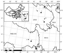
 | 图1 本文所收集序列和气象站点分布图 黑圆圈:1.Zhang2014, 2.Zhu2008, 3.Gou2008, 4.Zhu2011, 5.Fan2010, 6.Li2015; 黑三角:7.张掖站, 8.野牛沟站, 9.德令哈站, 10.兴海站, 11.波密站, 12.德钦站Fig.1 Locations of the six temperature series and six meteorological stations in this study Black dots: 1.Zhang2014, 2.Zhu2008, 3.Gou2008, 4.Zhu2011, 5.Fan2010, 6.Li2015; Black triangles: 7.Zhangye, 8.Yeniugou, 9.Delingha, 10.Xinghai, 11.Bomi, 12.Deqin |
| 表2 青藏高原东北部及东南部3条序列相关系数 Table 2 Correlation coefficients between the selected series in the eastern Tibetan Plateau |
为了验证集成重建序列的可靠性, 根据树轮采样点的位置, 本文还采用了6个气象站观测的月和年温度序列, 包括张掖站、野牛沟站和兴海站的月和年平均最低气温, 以及德令哈、德钦和波密气象站月和年平均温度数据, 气象站位置见图1。所有气象数据均来源于中国气象数据共享网(http:∥data.cma.cn/)。
火山活动资料来源于史密斯苏尼亚火山研究所公布的火山喷发指数(Volcanic Explosivity Index, VEI)序列(http:∥volcano.si.edu/)。本文根据该序列选取了过去千年VEI为6和7的10次强火山喷发事件, 10° S~10° N的4次, 10° S~20° S 1次, 10° ~20° N的2次, 40° N以北3次(表3)。
| 表3 过去千年10次强火山喷发(VEI≥ 6)的喷发年份、经纬度和VEI等级 Table 3 The time, latitude, longitude and VEI of 10 volcanic eruptions (VEI≥ 6) in the past millennium |
6条温度序列在空间上均具有一定的代表性, 青藏高原东北部的3条序列在空间上高度相关[19, 26, 34], 青藏高原东南部的3条序列空间上同样高度相关[27, 32, 33], 因此可以用来集成区域温度变化。区域温度集成方法:首先将青藏高原东北部的3条序列按照公共时段分为3个阶段, 其中670— 1059年有1条序列, 1060— 1559年有2条序列, 1560— 2000年3条序列; 然后根据3个时段分别对每条序列进行标准化处理, 使每条序列在公共时段上的平均值均为0, 标准差为1; 之后对青藏高原东北部的3条序列分别在公共时段进行算术平均, 这样得到3段反映青藏高原东北部温度变化的指数序列; 最后对3段温度指数序列分别标准化处理, 相互衔接成一条序列, 反映青藏高原东北部区域的温度变化序列。同样, 青藏高原东南部也分为3个阶段, 即1385— 1584年仅1条序列, 1585— 1689年2条序列, 1690— 2000年3条序列。之后用同样的方法进行处理, 最后得到1条反映青藏高原东南部的温度变化序列。
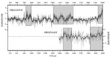
本文分别利用3条序列集成重建了青藏高原东北部670— 2000年和青藏高原东南部1385— 2000年的温度变化序列(图2)。根据原始重建序列反映的温度信息, 青藏高原东北部序列主要反映区域冬春季的温度变化, 而青藏高原东南部揭示的是区域夏季温度变化。本文将1385— 2000年温度指数均值作为正常情况, 高于其值为暖, 低于其值为冷。根据该标准, 在青藏高原东北部, 过去1 330年存在3个冷期(670— 920年, 1000— 1310年和1590— 1930年)和3个暖期(920— 1000年, 1310— 1590年和1930— 2000年); 在青藏高原东南部, 过去615年存在2个明显的冷期(1385— 1450年和1570— 1820年)和2个暖期(1450— 1570年和1820— 2000年)。在过去615年, 虽然这2个区域冷暖期存在一定的一致性, 但冷暖期的起止时间存在差异, 如青藏高原东南部1450— 1570年的暖期与青藏高原东北部1310— 1590年暖期部分重合, 而青藏高原东南部1820— 2000年暖期长于青藏高原东北部1930— 2000年的暖期。这可能是由于区域差异和反映的不同季节温度差异造成的。青藏高原东南部地处高原上的较低纬度, 受西南季风和东南季风影响, 水热条件较好; 而东北部气候高寒, 其北部边缘受东南季风影响, 而内部地区属于柴达木盆地一部分, 常年盛行西风[42]。局地的大气环流差异造成了温度变化的差异。
此外, 本文利用张掖和野牛沟站月和年平均最低温度的均值、兴海气象站月和年平均最低温度, 以及德令哈、德钦和波密气象站的月和年均温度数据分别计算了前一年秋季(前一年9~11月), 当年冬季(前一年12月至当年2月)、春季(当年3~5月)和夏季(当年6~8月), 以及年温度与青藏高原东北部和东南部集成重建序列的相关系数, 结果见表4和表5。从季节的相关系数来看(表4), 青藏高原东北部温度序列与张掖和野牛沟冬、春和夏季, 德令哈站秋和冬季, 兴海四季, 波密冬季, 以及德钦秋、春和夏季温度在α =0.01水平上均显著相关; 青藏高原东南部温度序列与兴海、波密和德钦夏季温度在α =0.01水平上均显著相关。该结果表明青藏高原东北部集成重建序列主要反映了冬春季温度变化, 而青藏高原东南部序列主要反映了区域夏季温度变化, 基本上与原始序列重建的温度信息相吻合。从与年温度相关系数看(表5):青藏高原东北部的集成序列与选取的气象站点年温度序列在α =0.01水平上均显著相关; 而青藏高原东南部与气象站点温度数据相关系数相对较小, 与德令哈气象站的年平均温度在α =0.05水平上显著相关, 与兴海和波密气象站在α =0.01水平上显著相关。此结果表明, 青藏高原东北部温度序列能代表更大的区域温度变化, 同时也反映了冬半年温度更能代表年温度变化[43]。从整个相关分析结果来看, 虽然青藏高原东南部3条序列中1条与其他2条相关性较差(表2), 但是集成结果与站点温度显著相关, 说明这3条序列集成可以反映区域温度变化。
 | 图2 青藏高原东北部冬春季和东南部夏季温度变化 灰色曲线为温度距平值, 黑色粗曲线是11年平滑曲线Fig.2 The winter-spring temperature variations in northeastern Tibetan Plateau and summer temperature variations in southeastern Tibetan Plateau Grey line: Temperature anomaly; Thick black line: 11-year smoothing values |
| 表4 青藏高原东北部(NE)和东南部(SE)集成温度序列与季节观测温度的相关系数 Table 4 Correlation coefficients of instrumental seasonal temperature and the reconstructed temperature in Northeastern Tibetan Plateau (NE) and Southeastern Tibetan Plateau (SE) |
| 表5 青藏高原东北部(NE)和东南部(SE)集成温度序列与观测年温度的相关系数 Table 5 Correlation coefficients of instrumental annual temperature and the reconstructed temperature in Northeastern Tibetan Plateau (NE) and Southeastern Tibetan Plateau (SE) |
根据火山喷发的纬度分布, 本文利用SEA方法探讨了火山喷发对青藏高原东部温度的影响(图3)。结果显示:位于10° S~10° N的火山喷发事件导致青藏高原东北部在火山喷发后第一年明显降温(图3a); 青藏高原东南部第一年也出现降温, 但未达到显著水平, 第二年降温显著(图3d)。热带地区强火山将火山灰喷发到平流层, 形成气溶胶, 平流层经圈环流将气溶胶往极地方向传送, 在1~2年内传送到高纬度地区[2]。气溶胶在平流层阻碍太阳辐射到达地表。因此, 热带地区强火山喷发引起青藏高原东部在其后1~2年内发生降温。其他纬度的强火山喷发事件也引起青藏高原东北部和东南部第一年均发生降温, 但均未达到显著水平(图3b, c, e, f); 青藏高原东北部第4年降温明显, 达到显著水平(图3b和c)。因为高纬度的火山喷发在平流层形成的气溶胶很少能传送到同半球的中纬度以南, 火山灰形成的气溶胶在平流层的扩散速度极大程度上取决于火山喷发时风速[2]。因此, 中高纬度火山喷发对青藏高原东部温度的影响较弱, 并且在青藏高原东北部和东南部产生差异。这和其他研究结果一致, 即热带地区火山喷发影响范围较广, 能影响半球, 甚至全球的温度变化, 而其他区域的火山影响范围较小, 且存在区域差异[44]。因为火山喷发的影响取决于其喷发的位置和时间、喷发强度、区域气候类型等, 这些因素能干扰局地的大气环流, 导致一些地区变冷, 而另外一些地区温度没有发生明显变化, 甚至变暖[11, 14, 44, 45]。这可能主要是由于火山喷发的季节、纬度和强度等的差异, 导致喷发物的空间特征不同, 对辐射的影响不同, 引起了不同区域之间降温出现的时间和降温幅度不一致[44]。如Esper等[15]对北欧和中欧研究结果表明:强火山喷发对北欧和中欧的影响存在差异, 对北欧影响较大, 喷发后2年降温幅度较大; 而中欧降温幅度较小, 一般发生在火山喷发后的1年内。此外, 由于两区域序列反映了不同季节的温度, 这也是造成不同火山活动对青藏高原东北部和东南部温度影响差异的原因之一[2]。
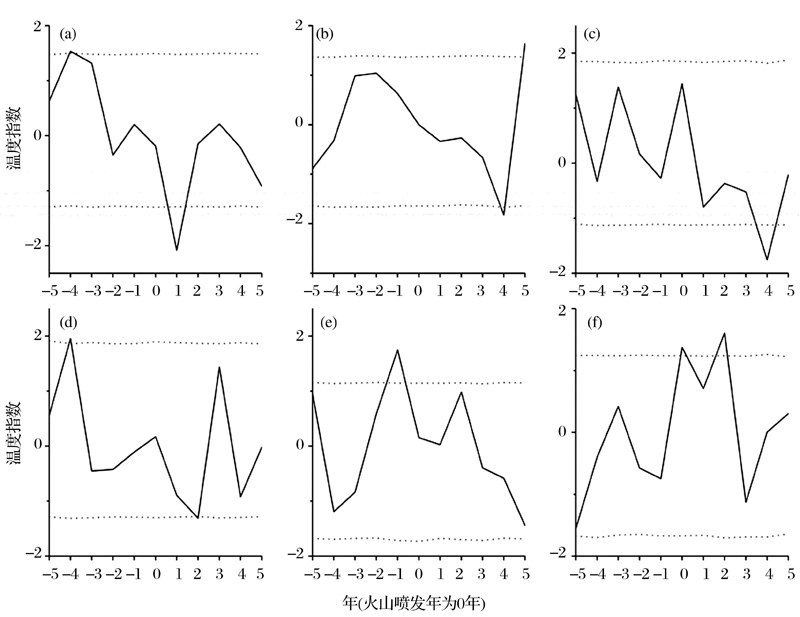 | 图3 10次强火山喷发(VEI≥ 6)对青藏高东部过去1 000年温度变化影响的时序叠加法分析结果 (a), (b)和(c)分别代表10° S~10° N、南北纬10° ~40° 及北纬40° 以北强火山喷发对青藏高原东北部温度变化影响分析结果; (d), (e)和(f)分别为10° S~10° N、南北纬10° ~40° 及北纬40° 以北强火山喷发对青藏高原东南部温度变化影响分析结果; 虚线表示95%置信度Fig.3 Superposed epoch analyses centered on 10 large volcanic eruptions (VEI≥ 6) of the past millennium in the eastern Tibetan Plateau (a)~(c): The impact of large volcanic eruptions in 10° S~10° N, 10° ~40° S/N and north of 40° N on the northeastern Tibetan Plateau, respectively; (d)~(f): The impact of large volcanic eruptions in 10° S~10° N, 10° ~40° S/N and north of 40° N on the southeastern Tibetan Plateau, respectively. The dot lines:95% confidence limit |
本文基于树轮资料集成重建了青藏高原东北部和东南部过去千年的温度序列。在过去1 300多年, 青藏高原东北部存在3个明显的冷期(670— 920年、1000— 1310年和1590— 1930年)和3个明显的暖期(920— 1000年、1310— 1590年和1930— 2000年); 过去600多年, 青藏高原东南部存在2个明显的冷期(1385— 1450年和1570— 1820年)和2个明显的暖期(1450— 1570年和1820— 2000年)。时序叠加法分析结果表明:10° S~10° N的强火山喷发后第一年青藏高原东北部温度降低显著, 青藏高原东南部发生降温, 第二年达到显著; 其他纬度的强火山喷发对青藏高原东北部和东南部的温度影响存在一定差异, 虽然喷发后第一年青藏高原东北部和东南部均降温, 但不显著, 东北部在第4年降温显著, 这可能是由于区域差异, 也有可能由于火山喷发的季节、纬度和强度等的差异, 引起了不同区域之间降温出现的时间和降温的幅度不一致。
本文在分析火山活动和区域温度的关系时, 仅仅考虑了火山喷发的强度和位置, 而没有考虑火山喷发的季节、类型等因素。在未来的研究中需要考虑更多的影响因素, 如按照不同的区域、不同季节进行分类探讨, 揭示火山活动对区域温度变化的影响。
致 谢:感谢中国科学院西双版纳热带植物园范泽鑫研究员、兰州大学勾晓华教授、中国科学院青藏高原研究所朱海峰博士以及中国科学院地理科学与资源研究所王丽丽研究员、张永和李名勇博士提供的重建序列数据。衷心感谢两名审稿人对文章提出的建设性修改意见。
The authors have declared that no competing interests exist.
| [1] |
|
| [2] |
|
| [3] |
|
| [4] |
|
| [5] |
|
| [6] |
|
| [7] |
|
| [8] |
|
| [9] |
|
| [10] |
|
| [11] |
|
| [12] |
|
| [13] |
|
| [14] |
|
| [15] |
|
| [16] |
|
| [17] |
|
| [18] |
|
| [19] |
|
| [20] |
|
| [21] |
|
| [22] |
|
| [23] |
|
| [24] |
|
| [25] |
|
| [26] |
|
| [27] |
|
| [28] |
|
| [29] |
|
| [30] |
|
| [31] |
|
| [32] |
|
| [33] |
|
| [34] |
|
| [35] |
|
| [36] |
|
| [37] |
|
| [38] |
|
| [39] |
|
| [40] |
|
| [41] |
|
| [42] |
|
| [43] |
|
| [44] |
|
| [45] |
|