Research Progress on Aeolian Sand Process Near Ground in Oasis-Desert Transitional Zone
Zhang Kecun, An Zhishan, Cai Diwen, Guo Zichen, Wang Junzhan
Dunhuang Gobi and Desert Ecology and Environment Research Station/Key Laboratory of Desert and Desertification, Cold and Arid Regions Environmental and Engineering Research Institute, Chinese Academy of Sciences, Lanzhou 730000, China
Abstract
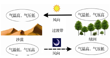
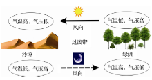
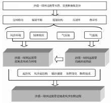
Controlled by the landscape pattern of oasis and desert,the oasis-desert transitional zone is very sensitive to the change of environmental conditons. The processes of wind-blown sand in the oasis-desert transitional zone have direct impact on the stability and development of oasis. Local circulation and microclimate induced by the gradient differences of environment factors between oasis and desert such as vegetation, relief, underlying surface, hydrographic and meteorological factors and so on have restricted the back and forward of desert or the transition of oasis. This paper summarizes the latest research achievements in such six aspects that include local climate, soil erosion, sand storms, aeolian environments, sand transport and prevention system of sand damages. It is expected to solve the problems of sand damages and ensure ecological safety of oasis. Moreover, it will provide scientific evidence for establishing the oasis-protection system in arid region,which is both significant in theory and in practice.
Keyword:
Oasis-desert transitional zone; Special research; Aeolian sand process; Prevention sysytem of sand damages.
WenZixiang, DongGuangrong, QuJianjun. Paying emphasis on the study of desert oasis in China[J]. Advances in Earth Science, 1996, 11(3): 270-274. [文子祥, 董光荣, 屈建军. 应重视和加强我国沙漠绿洲的研究[J]. 地球科学进展, 1996, 11(3): 270-274. ][本文引用:1]
[2]
HuYinqiao, ZuoHongchao. Forming mechanism of oasis environmental and building countermeasure of ecological environment in arid area[J]. Plateau Meteorology, 2003, 22(6): 537-544. [胡隐樵, 左洪超. 绿洲环境形成机制和干旱区生态环境建设对策[J]. 高原气象, 2003, 22(6): 537-544. ][本文引用:1]
[3]
DangJianhua, Wahap·Halik, ZhangYuping, et al. A brief analysis of the situations of the urbanization development and the coordination in arid area[J]. Advances in Earth Science, 2014, 29(3): 420-428. [党建华, 瓦哈甫·哈力克, 张玉萍, 等. 干旱区绿洲城市城镇化发展状况及协调性浅析——以吐鲁番地区为例[J]. 地球科学进展, 2014, 29(3): 420-428. ][本文引用:1]
[4]
Salman AB, Howari FM, Sankary MM, et al. Environmental impact and natural hazards on Kharga Oasis monumental sites, Western Desert of Egypt[J]. Journal of African Earth Sciences, 2010, 58: 341-353. [本文引用:1]
[5]
WangXunming, ZhouNa, LangLili, et al. Aeolian processes and their effects on terrestrial ecosystem: An overview[J]. Advances in Earth Science, 2015, 30(6): 627-635. [王训明, 周娜, 郎丽丽, 等. 风沙活动对陆地生态系统影响研究进展[J]. 地球科学进展, 2015, 30(6): 627-635. ][本文引用:1]
[6]
HanDelin. Artificial Oasis in Xinjiang[M]. Beijing: China Environmental Science Press, 2000. [韩德林. 新疆人工绿洲[M]. 北京: 中国环境科学出版社, 2000. ][本文引用:1]
[7]
Wang YG, LiY. Land exploitation resulting in soil salinization in a desert-oasis ecotone[J]. Catena, 2012, 100: 50-56. [本文引用:1]
[8]
AosierB, TsuchiyaK, KanekoM, et al. Land cover of oases and forest in Xinjiang, China retrieved from ASTER data[J]. Advances in Space Research, 2007, 39: 39-45. [本文引用:1]
[9]
Jia BQ, Zhang ZQ, Ci LJ, et al. Oasis land -use dynamics and its influence on the oasis environment in Xinjiang, China[J]. Journal of Arid Environments, 2004, 30: 11-26. [本文引用:1]
[10]
ZhangQiang, YaoYubi, LiYaohui, et al. Research progress and prospect on the monitoring and early warning and mitigation technology of meteorological drought disaster in northwest China[J]. Advances in Earth Science, 2015, 30(2): 196-213. [张强, 姚玉璧, 李耀辉, 等. 中国西北地区干旱气象灾害监测预警与减灾技术研究进展及其展望[J]. 地球科学进展, 2015, 30(2): 196-213. ][本文引用:1]
[11]
LadjiR, YassaaN, BalducciC, et al. Organic components of Algerian desert dusts[J]. Chemosphere, 2010, 81: 925-931. [本文引用:1]
[12]
LiuShuhua, LiuHeping, HuYu, et al. Numerical simulation of land surface physical processes and land -atmosphere interactions over oasis-desert/gobi region[J]. Science in China (Series D), 2007, 50(2): 290-295. [本文引用:1]
[13]
XingWenjuan, LeiJiaqiang, WangHaifeng, et al. Analysis on wind regime borne sand potential in a desert-oasis ecotone[J]. Arid Zone Research, 2008, 25(6): 894-898. [刑文娟, 雷加强, 王海峰, 等. 荒漠—绿洲过渡带风况及输沙势分析[J]. 干旱区研究, 2008, 25(6): 894-898. ][本文引用:2]
[14]
YangXinghua, HeQing, HuoWen, et al. Study on wind-blown sand characteristics at different directions near the surface in the frontier of an oasis-desert ecotone in Qira County, Xinjiang[J]. Arid Zone Research, 2012, 29(6): 1 100-1 104. [杨兴华, 何清, 霍文, 等. 策勒绿洲—荒漠过渡带风沙前沿近地面不同方向的输沙特征[J]. 干旱区研究, 2012, 29(6): 1 100-1 104. ][本文引用:1]
[15]
WangTao. Advances and trends of oasisization and desertification in arid zone[J]. Journal of Desert Research, 2009, 29: 1-9. [王涛. 干旱区绿洲化、荒漠化研究的进展与趋势[J]. 中国沙漠, 2009, 29: 1-9. ][本文引用:1]
[16]
DongZhibao. 50 years of wind-blown sand physics in China (1)[J]. Journal of Desert Research, 2005, 25: 293-305. [董治宝. 中国风沙物理50年(1)[J]. 中国沙漠, 2005, 25: 293-305. ][本文引用:1]
ZhangHui, ZhangZhiqiang. Studies on the quantitative relation between economic development and ecological environment of Minqin county[J]. Advances in Earth Science, 2014, 29(5): 632-639. [张惠, 张志强. 民勤县经济发展与生态环境的定量关系研究[J]. 地球科学进展, 2014, 29(5): 632-639. ][本文引用:1]
[19]
ZhuZhenda, WuZheng, LiuShu, et al. Outline of China Desert[M]. Beijing: Science Press, 1980: 90-94. [朱震达, 吴正, 刘恕, 等. 中国沙漠概论[M]. 北京: 科学出版社, 1980: 90-94. ][本文引用:1]
[20]
ZhangKebin. Some problem about desert oasis exploitation in Northwestern China[J]. Journal of Beijing Forestry University, 1986, 1: 124-128. [张克斌. 关于我国西北沙漠绿洲开发中的若干问题[J]. 北京林业大学学报, 1986, 1: 124-128. ][本文引用:1]
MuGuijin, HeJunxia, LeiJiaqiang, et al. A discussion on the transitional zone from oasis to sand y desert: A case study at Cele Oasis[J]. Arid Land Geography, 2013, 36: 195-202. [穆桂金, 贺俊霞, 雷加强, 等. 再议绿洲—沙漠过渡带——以策勒绿洲—沙漠过渡带为例[J]. 干旱区地理, 2013, 36: 195-202. ][本文引用:1]
[23]
DongZhi, LiHongli. Comprehensive control technology system of sand disasters in artificial oases in Ulan Buh Desert[J]. Journal of Desert Research, 2011, 31: 339-345. [董智, 李红丽. 乌兰布和沙漠人工绿洲沙害综合控制技术体系[J]. 中国沙漠, 2011, 31: 339-345. ][本文引用:1]
[24]
WangTao, ZhaoHalin. 50 years of Chinese desert science[J]. Journal of Desert Research, 2005, 25: 145-165. [王涛, 赵哈林. 中国沙漠科学的五十年[J]. 中国沙漠, 2005, 25: 145-165. ][本文引用:1]
[25]
ZhangZhengcai, DongZhibao. Research progress on aeolian geomorphology and morphodynamics[J]. Advances in Earth Science, 2014, 29(6): 734-747. [张正偲, 董治宝. 风沙地貌形态动力学研究进展[J]. 地球科学进展, 2014, 29(6): 734-747. ][本文引用:1]
[26]
SuCongxian, HuYinqiao. Cold Island effect over oasis and lake[J]. Chinese Science Bulletin, 1988, 33(12) : 1 023-1 026. [本文引用:1]
ZhangQiang, ZhaoMing. Field experiment and numerical simulation of inverse humidity of atmosphere over desert near oasis[J]. Acta Meteorologica Sinica, 1999, 57(6): 729-740. [张强, 赵明. 绿洲附近荒漠大气逆湿的外场观测和数值模拟[J]. 气象学报, 1999, 57(6): 729-740. ][本文引用:1]
[29]
PotchterO, GoldmanD, KadishD. The oasis effect in an extremely hot and arid climate: The case of southern Israel[J]. Journal of Arid Environments, 2008, 72: 1 721-1 733. [本文引用:1]
[30]
LüShihua, ShangLunyu. Numerical simulation of characteristics of wind field, air temperature and humidity in Jinta Oasis, Hexi Corridor[J]. Journal of Desert Research, 2005, 25(5): 623-628. [吕世华, 尚伦宇. 金塔绿洲风场与温湿场特征的数值模拟[J]. 中国沙漠, 2005, 25(5): 623-628. ][本文引用:1]
[31]
GuZhaolin, ZhaoYongzhi, YuYongzhang, et al. Numerical study of formation evolution and structure of dust devil[J]. Acta Meteogologica Sinica, 2003, 61(6): 751-759. [顾兆林, 赵永志, 郁永章, 等. 尘卷风的形成、结构和卷起沙尘过程的数值研究[J]. 气象学报, 2003, 61(6): 751-759. ][本文引用:1]
[32]
Richard WT, Steven RE, Terry AH. The Bowen ratio-energy balance method for estimating latent heat flux of irrigated alfalfa evaluated in a semiarid, advective environment[J]. Agricultural and Forest Meteorology, 2000, 103: 335-348. [本文引用:1]
[33]
HuYinqiao, WangJunqin, ZuoHongchao. Character of water vapor transportation in the surface layer over desert near oasis[J]. Plateau Meteorology, 1993, 12(2): 125-132. [胡隐樵, 王俊勤, 左洪超. 临近绿洲的沙漠上空近地面层内水汽输送特征[J]. 高原气象, 1993, 12(2): 125-132. ][本文引用:1]
[34]
Misak RF, Draz MY. Sand drift control of selected coastal and desert dunes in Egypt: Case studies[J]. Journal of Arid Environments, 1997, 35: 17-28. [本文引用:1]
[35]
WangHui, HuZeyong, LiDongliang, et al. Comparative of climatologic characteristics of the surface radiation balance on Dingxin Gobi and Zhangye oasis and desert underlaying surfaces in Heihe watershed, Gansu[J]. Journal of Glaciology and Geocryology, 2009, 31: 464-473. [王慧, 胡泽勇, 李栋梁, 等. 黑河地区鼎新戈壁与绿洲和沙漠下垫面地表辐射平衡气候学特征的对比分析[J]. 冰川冻土, 2009, 31: 464-473. ][本文引用:1]
[36]
ThomasT. Desert Meteorology[M]. Cambridge: Cambridge University Press, 2004: 224-242. [本文引用:1]
[37]
ZhengHaixia, WangJiemin, MaitaniToshihiko, et al. Some characteristics of energy exchange at the underlying surface of desert and oasis in Hexi Corridor[J]. Acta Ecologica Sinica, 2000, 20: 88-92. [郑海霞, 王介民, 米谷俊颜, 等. 河西走廊沙漠和绿洲下垫面生态条件下能量交换若干特征[J]. 生态学报, 2000, 20: 88-92. ][本文引用:1]
[38]
ShenZhibao, ZouJiling. The radiative energy budget on the ground surface over desert and oasis in Heihe area[J]. Plateau Meteorology, 1994, 13: 314-322. [沈志宝, 邹基玲. 黑河地区沙漠和绿洲的地面辐射收支[J]. 高原气象, 1994, 13: 314-322. ][本文引用:1]
[39]
ChenShiqiang, LüShihua, AoYinhuan, et al. Preliminary analysis on ground level wind field of second circulation in Jinta oasis and desert in summer[J]. Plateau Meteorology, 2005, 24(4): 534-539. [陈世强, 吕世华, 奥银焕, 等. 夏季金塔绿洲与沙漠次级环流近地表风场的初步研究[J]. 高原气象, 2005, 24(4): 534-539. ][本文引用:1]
[40]
LüShihua, ChenYuchun, ChenShiqiang, et al. Preliminary study of thermodynamic of oasis-desert interaction in Hexi area in summer[J]. Plateau Meteorology, 2004, 23(2): 127-132. [吕世华, 陈玉春, 陈世强, 等. 夏季河西地区绿洲—沙漠环境相互作用的热力过程的初步分析[J]. 高原气象, 2004, 23(2): 127-132. ][本文引用:1]
[41]
JiaLi, WangJiemin. The local and effective aerodynamic roughness length of a complex land scape of oasis and desert[J]. Acta Meteorologica Sinica, 1999, 57(3): 346-357. [贾立, 王介民. 绿洲沙漠复合地表条件下的局地和有效粗糙度[J]. 气象学报, 1999, 57(3): 346-357. ][本文引用:1]
[42]
Bo TL, ZhengX J. Nunerical simulation of the evolution and propagation of aeolian dune fields toward a desert-oasis zone[J]. Geomophology, 2013, 180/181: 24-32. [本文引用:2]
GuZhaolin, QiuJian, LuLuyi, et al. Advances in study of dust devils[J]. Journal of Desert Research, 2007, 27(5): 843-850. [顾兆林, 邱剑, 鲁录义, 等. 尘卷风的研究进展[J]. 中国沙漠, 2007, 27(5): 843-850. ][本文引用:2]
[45]
ZhangZhigang, GaoQingxian, JiaoMeiyan, et al. Analysis on source locations and transportation paths of sand -dust affecting Beijing[J]. Research of Environmental Sciences, 2007, 20: 21-27. [张志刚, 高庆先, 矫梅燕, 等. 影响北京地区沙尘天气的源地和传输路径分析[J]. 环境科学研究, 2007, 20: 21-27. ][本文引用:1]
[46]
GuZhaolin. Eolian Dust: Turbulent Current and Gas—Solid Two-Phase Flow of Air And Solid Near Earth Surfaces[M]. Beijing: Science Press, 2010. [顾兆林. 风扬粉尘——近地层湍流与气固两相流[M]. 北京: 科学出版社, 2010. ][本文引用:1]
[47]
ZhaoMing, ZhanKejie, YangZihui, et al. Characteristics of the lower layer of sand storms in the Minqin desert-oasis zone[J]. Science in China (Series D), 2011, 54(5): 703-710. [本文引用:1]
[48]
YangXinghua, HeQing, ChengYujing, et al. Near-surface horizontal aeolian sand -dust flux over an oasis-desert ecotone in Qira County, Xinjiang[J]. Arid Zone Research, 2013, 30: 1 100-1 105. [杨兴华, 何清, 程玉景, 等. 策勒绿洲荒漠过渡带风沙前沿近地表沙尘水平通量观测[J]. 干旱区研究, 2013, 30: 1 100-1 105. ][本文引用:1]
[49]
ZhaoMing, FangEtian, ZhanKejie, et al. Construction of near surface dust storm monitoring system in Minqin and evaluation on its operation[J]. Journal of Desert Research, 2008, 28: 1 163-1 168. [赵明, 方峨天, 詹科杰, 等. 民勤地区近地面沙尘监测系统的建立及其运行的初步评价[J]. 中国沙漠, 2008, 28: 1 163-1 168. ][本文引用:1]
[50]
ZhangKecun, QuJianjun, MaZhonghua. The environmental characteristics of sand -dust storm in Minqin over recent 50 years[J]. Journal of Desert Research, 2004, 24: 257-260. [张克存, 屈建军, 马中华. 近50年民勤沙尘暴的环境特征[J]. 中国沙漠, 2004, 24: 257-260. ][本文引用:1]
[51]
WangYongsheng, YangWenbin, LiYonghua, et al. Wind regime and resultant sand -transporting potential in the desert-oasis ecotone in the eastern marginal zone of the Kumtag Desert[J]. Journal of Arid Land Resources and Environment, 2015, 29: 140-144. [王永胜, 杨文斌, 李永华, 等. 库姆塔格沙漠东缘荒漠绿洲过渡带风况及输沙势[J]. 干旱区资源与环境, 2015, 29: 140-144. ][本文引用:1]
[52]
ZouXueyong, ZhangChunlai, ChengHong, et al. Classification and representation of factors affecting soil wind erosion in a model[J]. Advances in Earth Science, 2014, 29(8): 875-889. [邹学勇, 张春来, 程宏, 等. 土壤风蚀模型中的影响因子分类与表达[J]. 地球科学进展, 2014, 29(8): 875-889. ][本文引用:3]
[53]
LiuGuoqing, LiShaokun, BaiJunhua, et al. Study on soil wind erosion of the main Earth’s surface in Hetian district[J]. Journal of Soil and Water Conservation, 2008, 22: 7-10. [刘国庆, 李少昆, 柏军华, 等. 和田地区主要土地类型风蚀研究[J]. 水土保持学报, 2008, 22: 7-10. ][本文引用:1]
[54]
MaoDonglei, LeiJiaqiang, ZengFanjiang, et al. Sand erosion and deposition on different underlying land surfaces in the desert-oasis ecotone in Cele, Xinjiang, China[J]. Journal of Desert Research, 2014, 34: 961-969. [毛东雷, 雷加强, 曾凡江, 等. 新疆策勒沙漠绿洲过渡带不同下垫面地表蚀积变化特征[J]. 中国沙漠, 2014, 34: 961-969. ][本文引用:2]
[55]
WangPing, WangYan. Characteristics of aeolian sediment under different underlying surfaces in oasis-desert transitional region of Minqin[J]. Transactions of the Chinese Society of Agricultural Engineering, 2012, 28: 138-145. [王萍, 王燕. 民勤荒漠绿洲过渡带不同下垫面条件的土壤风蚀特征[J]. 农业工程学报, 2012, 28: 138-145. ][本文引用:2]
[56]
LiuYanping, LiuTiejun, MengZhongju. Wind tunnel simulation test on the influence factors of wind erosion in grassland areas[J]. Journal of Desert Research, 2013, 33(3): 668-672. [刘艳萍, 刘铁军, 蒙仲举. 草原区植被对土壤风蚀影响的风洞模拟试验研究[J]. 中国沙漠, 2013, 33(3): 668-672. ][本文引用:1]
[57]
HongChuanxun. Analysis for the factors affecting soil wind erosion in Xinjiang Deserts[J]. Science of Soil and Water Conservation, 2013, 11: 25-28. [洪传勋. 新疆戈壁荒漠区域风蚀影响因子分析[J]. 中国水土保持科学, 2013, 11: 25-28. ][本文引用:1]
[58]
NanLing, DuLingtong, ZhanXiuli. Advances in study on soil erodibility for wind erosion[J]. Soils, 2014, 46(2): 204-211. [南岭, 杜灵通, 展秀丽. 土壤风蚀可蚀性研究进展[J]. 土壤, 2014, 46(2): 204-211. ][本文引用:1]
[59]
WangPing, ZhengXiaojing. Development of unsteady windblown sand transport[J]. Advances in Earth Science, 2014, 29(7): 786-794. [王萍, 郑晓静. 非平稳风沙运动研究进展[J]. 地球科学进展, 2014, 29(7): 786-794. ][本文引用:1]
[60]
ZhangChunlai, ZouXueyong, YangShuo, et al. Grain size characteristics of aeolian deposits in the shelterbelt of railway at Shapotou[J]. Geographical Research, 2007, 26(1): 75-82. [张春来, 邹学勇, 杨硕, 等. 沙坡头铁路防护体系内风沙沉积的粒度特征[J]. 地理研究, 2007, 26(1): 75-82. ][本文引用:1]
[61]
Liu LY, Gao SY, Shi PJ, et al. Wind tunnel measurements of adobe abrasion by blown sand : Profile characteristics in relation to wind velocity and sand flux[J]. Journal of Arid Environments, 2003, 53: 351-363. [本文引用:1]
[62]
LiSen, YangPing, GaoShangyu, et al. The dynamic changes and development trends of land aeolian desertification in Xizang Plateau over recently 10 years[J]. Advances in Earth Science, 2004, 19(1): 63-70. [李森, 杨萍, 高尚玉, 等. 近10 年西藏高原土地沙漠化动态变化与发展态势[J]. 地球科学进展, 2004, 19(1): 63-70. ][本文引用:1]
[63]
Hassan WN, Ribberink JS. Transport processes of uniform and mixed sand s in oscillatory sheet flow[J]. Coastal Engineering, 2005, 52: 745-770. [本文引用:1]
[64]
ZouXueyong, HaoQingzhen, ZhangChunlai, et al. The trajectory parameter analysis of saltation sand grains driven by wind[J]. Chinese Science Bulletin, 1999, 44(18): 1 681-1 685. [本文引用:1]
[65]
RaquelF, Almerindo DF, Sismeiro JL, et al. Wind tunnel and computational study of the stoss effect on the aeolian erosion of transverse sand dunes[J]. Aeolian Research, 2011, 3: 303-314. [本文引用:1]
[66]
Remigius EO. Wind tunnel study on aeolian saltation dynamics and mass flow[J]. Journal of Arid Environments, 2003, 53: 569-583. [本文引用:1]
[67]
HasiEerdum. Structural variations of sand -bearing airflow over dune at southeastern fringe of Tengger Desert[J]. Chinese Science Bulletin, 2004, 49(9): 942-948. [本文引用:1]
[68]
ZouXueyong, LiuYuzhang, DongGuangrong. Tentative Calculation of wind-sand current energy[J]. Chinese Science Bulletin, 1994, 39(12): 1 016-1 020. [本文引用:1]
Hesse PP, Simpson RL. Variable vegetation cover and episodic sand movement on longitudinal desert sand dunes[J]. Geomorphology, 2006, 81: 276-291. [本文引用:1]
[71]
Anderson RS. Eolian sediment transport as a stochastic process: The effects of a fluctuating wind on particle trajectories[J]. Journal of Geology, 1987, 95: 497-512. [本文引用:1]
[72]
Anderson RS, Haff PK. Simulation of aeolian saltation[J]. Science, 1988, 241: 820-823. [本文引用:1]
[73]
Anderson RS, Haff PK. Wind modification and bed response during saltation of sand in air[J]. Acta Mechanica, 1991, 1: 21-55. [本文引用:1]
[74]
MaoDonglei, LeiJiaqiang, LiShengyu, et al. Differences of sand transportation flux and sand grain size characteristics in different underlying surfaces on desert-oasis ecotone in Cele[J]. Journal of Arid Land Resources and Environment, 2014, 28: 167-174. [毛东雷, 雷加强, 李生宇, 等. 策勒沙漠绿洲过渡带不同下垫面的输沙通量及粒度差异特征[J]. 干旱区资源与环境, 2014, 28: 167-174. ][本文引用:1]
[75]
MaoDonglei, LeiJiaqiang, WangCui, et al. Characteristics of sand flow structure and sand transportation particles in Cele desert-oasis ecotone of Xinjiang Wei Autonomous Region[J]. Bulletin of Soil and Water Conservation, 2015, 35: 25-33. [毛东雷, 雷加强, 王翠, 等. 新疆策勒县沙漠—绿洲过渡带风沙流结构及输沙粒度特征[J]. 水土保持通报, 2015, 35: 25-33. ][本文引用:1]
[76]
QianYibing, ZhangXiming, LiXiaoming. A study on grain-size features of sand material of the oases in the southern margin of the Taklimakan Desert[J]. Journal of Desert Research, 1995, 15: 131-135. [钱亦兵, 张希明, 李晓明. 塔克拉玛干沙漠南缘绿洲沙物质粒度特征[J]. 中国沙漠, 1995, 15: 131-135. ][本文引用:1]
[77]
PangYingjun, LeiJiaqiang, ZengFanjiang, et al. Microclimate change of oasis-desert transitional zone in Qira county of Xinjiang Wei Autonomous Region[J]. Bulletin of Soil and Water Conservation, 2011, 31: 240-245. [庞营军, 雷加强, 曾凡江, 等. 新疆维吾尔自治区策勒县绿洲—沙漠过渡带小气候特征[J]. 水土保持通报, 2011, 31: 240-245. ][本文引用:1]
[78]
WangXueqin, YangDongliang, MaYang, et al. Wind fluctuation over three typical ground surfaces in desert-oasis ecotone: A case study at the southern rim of the Taklimakan Desert[J]. Journal of Desert Research, 2015, 35(3): 542-548. [王雪芹, 杨东亮, 马洋, 等. 沙漠绿洲过渡带典型下垫面风速脉动特征——以塔克拉玛干沙漠南缘策勒绿洲为例[J]. 中国沙漠, 2015, 35(3): 542-548. ][本文引用:1]
[79]
HuangXincheng, LiuBo, WangXufeng, et al. A numerical simulation of sand particle concentration profiles based on the distribution of the initial lift-off velocity[J]. Journal of Desert Research, 2015, 35(3): 534-541. [黄新成, 刘博, 王旭峰, 等. 基于起跳初速度分布的沙颗粒浓度廓线的数值模拟[J]. 中国沙漠, 2015, 35(3): 534-541. ][本文引用:1]
WuJianjun, LuoShenghu, YanGuanghu, et al. Numerical simulation on windblown sand clound in the fluctuating wind field[J]. Journal of Desert Research, 2011, 31(3): 602-606. [武建军, 罗生虎, 闫光虎, 等. 脉动风场下风沙流结构的数值模拟[J]. 中国沙漠, 2011, 31(3): 602-606. ][本文引用:1]
[82]
YangJiecheng, ZhangYu, LiuDayou, et al. CFD-DEM simulation of three dimensional aeolian sand movement[J]. Science in China (Series G), 2010, 53(7): 1 306-1 318. [本文引用:1]
[83]
XiaXuncheng, YangGensheng. Some issues about sand storms in northwest China[J]. Journal of Chinese Academy of Science, 1994, 4: 346-350. [夏训诚, 杨根生. 关于西北地区风沙尘暴的几个问题[J]. 中国科学院院刊, 1994, 4: 346-350. ][本文引用:1]
[84]
DongZhi, LiHongli, SunBaoping, et al. The change of sand -wind climate and response to the shelter belt system construction in the Northeastern Ulanbuh Desert[J]. Journal of Arid Land Resources and Environment, 2004, 18: 269-275. [董智, 李红丽, 孙保平, 等. 乌兰布和沙漠东北缘磴口县沙尘天气变化规律及其对防护林体系建设的响应[J]. 干旱区资源与环境, 2004, 18: 269-275. ][本文引用:1]
[85]
HeLingyun, Haimiti·Yimiti. Lack and loss of oasis-desert ecotone layer structure during the process of oasis development and the change of oasis protection way[J]. Journal of Arid Land Resources and Environment, 2010, 24: 94-96. [贺凌云, 海米提·依米提. 论绿洲发展过程中绿洲—荒漠交错带圈层结构的缺失及绿洲防护方式的改变[J]. 干旱区资源与环境, 2010, 24: 94-96. ][本文引用:1]
[86]
Pan XL, Chao JP. Theory of stability, and regulation and control of ecological system in oasis[J]. Global and Planetary Change, 2003, 37: 287-295. [本文引用:1]
[87]
ZhangJinchun, ZhaoMing, FangEtian, et al. Seasonal variations of sand storm-aerosol concentration near the ground surface around Minqin[J]. Acta Scientiae Circumstantiae, 2009, 29: 496-504. [张锦春, 赵明, 方峨天, 等. 民勤近地面沙尘暴气溶胶浓度变化特征初探[J]. 环境科学学报, 2009, 29: 496-504. ][本文引用:1]
[88]
SunTao, WangJihe, LiuHujun, et al. Analysis on vegetation characteristics of activating sand dunes in the oasis-desert ecotone[J]. Research of Soil and Water Conservation, 2009, 16: 174-178. [孙涛, 王继和, 刘虎俊, 等. 绿洲荒漠交错带活化沙丘的植物群落特征分析[J]. 水土保持研究, 2009, 16: 174-178. ][本文引用:1]
[89]
TianYuan, DingJianli, Tashpolat·Tiyip, et al. Studies on driving forces to dynamic changes of arable land in arid area resulted from interaction of natural and human factors: A case study in Yutian oasis of Xinjiang Province[J]. Journal of Desert Research, 2009, 29: 1 162-1 168. [田源, 丁建丽, 塔西甫拉提·特依拜, 等. 自然与人文交互作用下的干旱区典型绿洲耕地动态变化驱动力分析——以新疆于田绿洲为例[J]. 中国沙漠, 2009, 29: 1 162-1 168. ][本文引用:1]
[90]
DongZhi, HaoYuguang, LingXia, et al. Partition of different ecological-function areas and its construction strategy in Ulan Buh oasis[J]. Journal of Arid land Resources and Environment, 2005, 19(7): 18-23. [董智, 郝玉光, 凌霞, 等. 乌兰布和沙漠绿洲不同生态功能区划及其建设策略[J]. 干旱区资源与环境, 2005, 19(7): 18-23. ][本文引用:1]
[91]
LiuXinmin, WuZuoqi, WangHonglou, et al. A discussion on aeolian desertification control of north Linze oasis in Gansu Province[J]. Journal of Desert Research, 1982, 2: 9-15. [刘新民, 吴佐祺, 王宏楼, 等. 甘肃临泽绿洲北部沙漠化防治的探讨[J]. 中国沙漠, 1982, 2: 9-15. ][本文引用:1]
[92]
BaiYungang, SongYudong, HongChuanxun, et al. A study of eco-protection system construction in oases around Taklimakan Desert[J]. Bulletin of Soil and Water Conservation, 2005, 25: 78-80. [白云岗, 宋郁东, 洪传勋, 等. 环塔里木盆地绿洲生态防护体系建设研究[J]. 水土保持通报, 2005, 25: 78-80. ][本文引用:1]
It is of great significance to conduct intensive study on the oases scattered in the arid deserts in China as special and comprehensive regional units. Desert oases are the optimum areas in arid desert, which is the would-be bases for our future economic development. It Is terribly urgent to construct and rehabilitate me desert oases as China’s economic development emphasis is shifted to the northwest of China. It must consider the desert oases as the beginning point and regional development bases, regards the regional economy, population, resources and environment as a whole system to develop and rehabilitate the arid desert oases. Therefore the study of desert oases should place emphasis on the optimum regulation of population, resources and environment, including resource bearing capacity and environment loading analysis; regulation of population, resources and environment for sustainable development; optimization of population economy and resource environment.
The build of oasis ecological environment has special important stratagem signification for the sustainable economy development in northwest China region.This paper reviews a series of the research results about the oasis microclimate.Based on the forming mechanism of oasis microclimate and the stability of oasis,we bring forward building of countermeasure the ecological environment in northwest arid area of our country and enhancing the oasis stability and anti-jamming ability.The paper indicate that protecting and building oasis ecological environment should use fully the microclimate characteristics of oasis cold island effect to develop inimitable climate ecology style with the limited water resource and the abundant solar heat resource.The oasis environment build should adopt distinct countermeasure for ecological environment with distinct oasis stability.The ecology build of well-run oasis should develop the ecological agriculture with more drought resistant and temperature-enjoying crops to enhance the efficiency and make the full of use of water resource.The low efficiency oasis should adjust the oasis structure as much as possible,and link the patch oases as unit unity and try hard to minish the clothesline effect.The countermeasure of ecological environment build for the degenerate oasis should rehabilitate the ecosystem under the condition of enough supplying the water resource,and should restrict the exploitation of groundwater,the development of the agriculture and the animal husbandry to restrain more degeneration of the ecosystem.
1. The Key Laboratory for Oasis Ecosystem of MOE, Xinjiang University, Urumqi 830046, China; 2. College of Resource and Environment Science, Xinjiang University, Urumqi 830046, China; 3. College of Tourism Management, Xinjiang University, Urumqi 830046, China
The urbanization is the necessary way for the economic development of a country or region and at the same time one of the important signs to measure the level of economic development in a region. This study focuses on the urbanization in Turpan area to analyze the situation and the coordination of the urbanization development in the oasis of the arid area. By building the index system of urbanization in population, economy, society and ecology system including 16 evaluation index and using the entropy-based weight to determine the weight of each index, with the weighted sum of the Turpan area in 2001-2011, the urbanization of the composite index were quantitatively analyzed. Based on the situation of urbanization, the coordination of the urbanization is calculated and the future development trend on the mathematical models is predicted. On this basis, the development trend of Turpan area in the future is predicted with linear-regression analysis method and trend extrapolation method. Through the above information, the main driving force and the restricting factors of urbanization development in Turpan area can be found. Then, the specific suggestions and opinions in the development of the urbanization in Turpan area, even in the arid area are put forward. The innovation of this study is the study area located in the arid zone in oasis area and then the calculation of the coordination in the urbanization development process. Therefore, a more in-depth understanding of urbanization in the arid zone in oasis area is achieved.
Aeolian processes and the related material transports are the key land surface process, which play a major role in the ecologicial environments. This paper generialized the mechanisms of nutrient emission, transport, and deposition of the blown wind materials in arid and semiarid regions. Based on the results of enormous previous studies, the componets of the nutrients and materials, the source-sink models of the aeolian transports, the influence of nutrient loss and depositions on vegetation growth, reallocations and utilizations of the nutrients within wind blown materials on phytocommunity development, the responses of phytocommunity development to the aeolian transports in arid and semiarid regions were discussed. Finally, based on the current results of studies our colleagues acquired, pointed out that the researches in the near future may reveral the deposition mechanisms of aeolian materials in different terrestrial ecologicial systems, appraise the composition and effect contents of the nutrients, highlight the dominant transporting routes of the aeolian nutrients, found the source-sink models of the nutrients, analyze the responses between the aeolian activity and vegetation formation, and by adopting the integrated qualitative and quantitative methodologies understand the dynamic relationships between the aeolian activity and vegetation evolution. The related studies may further improve the understanding of the roles of the aeolian transport on terrestrial ecosystem evolution, thereby providing new evidence for the theories of arid geomorphology and providing academic supports for local ecological remediation of arid and semiarid regions.
Drought disaster is an important natural factor to restrict the socio-economic development, agricultural production and ecological civilization construction in Northwest China.With the global warming, the frequency and intensity of extreme drought events show a significantly increasing trend and the impact of drought increases continually. The results of “the research on monitoring and early warning and mitigation technology of meteorological drought disaster” have been obtained based on the support from dozens of national research projects in the past two decades. These projects have received a series of innovative achievements by long-term theoretical research and applied technology development through the continuous study around the formation mechanism, monitoring and early warning methods of meteorological drought and its impact on agricultural industry, the drought disaster prevention and mitigation technology and other relative scientific issues as well. The major achievements are as follows: New knowledge on the drought formation mechanism and the law of occurrence and development of severe drought events, especially the discovery of four main physical ways of drought circulation modals were obtained in Northwest China. The new drought prediction and monitor indices, and the new equipment of monitoring field evapotranspiration were developed in Northwest China, and these obviously improved drought monitoring accuracy and pertinence. A new meteorological theory of mountain cloud physics was proposed. The exploitation and utilization technology of air cloud water resources were developed over Qilian Mountain, which is the national key ecological function zone with water conservation. The new laws of land surface moisture transport and recycling in arid and semi-arid areas, and the physical mechanism of self-sustaining of oasis were revealed. The new characteristics of impact of arid climate change on agro-ecological system were recognized. The response relationship of rain-fed agriculture to drought disaster was set up. The mitigation disaster technologies to cope with climate change in arid area were developed by using coated soil conservation, rainwater harvesting for supplemental irrigation, furrow cultivation, suitable sowing date and so on. These technologies provided a scientific scheme to the implementation of cropping systems, layout and structural adjustment of agriculture and efficient utilization of agricultural climate resources in Northwest China. The above achievements promote the technological level on drought disaster prevention and mitigation, cultivated research teams working on arid meteorological science and raised the service ability of arid meteorology in Northwest China. These results also play an important role in promoting socio-economic development, agricultural modernization and construction of ecological civilization. In addition, the authors covered the main fields which are in urgent need to be studied and possible breakthrough might be made in arid meteorology research in Northwest China in the future.
1. Institute of Desert Meteorology, China Meteorological Administration, Urumqi 830002, Xinjiang, China; 2. Taklimakan Station for Desert Atmospheric and Environmental Observation and Experiment, Tazhong 841000, Xinjiang, China; 3. Korla Meteorological Bureau, Korla 841000, Xinjiang, China
Aeolian sand transport is serious in many arid regions in the world, and it is considered to be as a significant part of global biogeochemical cycles. Furthermore, windblown sand brings often disasters. Therefore, widespread attention has been paid to the significance of aeolian sand transport in many fields, such as geomorphology, climatology, meteorology, ecology and environmental science. Windblown sand direction is a base for both studying the formation and evolution of aeolian geomorphology and carrying out the sand damage control measures. In this study, a statistical analysis on windblown sand direction in an oasisdesert ecotone in Qira County, located in the south marginal zone of the Tarim Basin, was carried out during the period from 2010 to 2011. Some preliminary conclusions are as follows: (1) In the study area, the wind directions of sanddriving wind are mainly W and WNW, and the change of wind direction is comparatively simple; (2) In the study area, the wind directions at which the values of sediment discharge are high are dominated by NW, WNW, W, SW and WSW, and the occurring frequency is as high as 68.3%. An aeolian sediment discharge of 96 kg passing through a height extent of 0-40 cm and 1cm width occurred. The annual resultant windblown sand amount is 45.9 kg, and the resultant windblown sand direction is 102.5°; (3) In the study area, the windblown sand potential and resultant windblown sand potential are 43.2 VU and 31.04 VU respectively. There is a considerable difference between the direction of windblown sand potential and the measured sediment discharge. It is recognized that windblown sand is a complex process, and various factors affecting windblow sand, such as wind speed, wind direction and underlying surface, should be comprehensively considered and researched.
Oasification and desertification are the two contrarily developing but correlated processes of arid regions. The area of osification of China has increased to 10.4×10⁴ km2 from 2.5×10⁴ km2 of the late 1950s in the past 60 years, simultaneously, the area of desertification has expanded from 5.3×10⁴ km2 to 11.4×10⁴ km2 and the arable land area suffered from salinization has reached up to 1.5×10⁴ km2, accounting for 30% of the total arable land area. The process of oasification has improved the local eco\|environment and extended the living space of human being, but the planless and low\|level development of oases has lowered the oasis stability and triggered a series of eco\|environmental problems, in which desertification involved. This paper reviewed the research progresses on oasification and desertification, and has put forward a general thinking and some important subjects waiting for performing in the near future against several key problems. The prospect of researches in this field lies in disclosing the forming of oasification and desertification as well as their evolution mechanism on the premise of completely cognizing the processes of Water\|Soil\|Atmosphere\|Biology and their interaction under functioning of anthropogenic activities and climatic changes, providing scientific bases for synthetically evaluating environment changing trend and environmental effect, formulating controlling strategies and management models.
Key Laboratory of Desert and Desertification, Cold and Arid Regions Environmental and Engineering Research Institute, Chinese Academy of Sciences, Lanzhou 730000, China
The aeolian physics research in China dates back to 1955 when aeolian research was started to control the blown sand in the north of China. This paper presents a detailed overall review of the research achievements in aeolian physics between the late 1950's and implantation of the CAS's Knowledge Innovation Project in the late 1990's. From the late 1950's to mid 1960's, aeolian physics research in China focused on introducing the basic knowledge with respect to blown sand movement from other countries, mainly the former Soviet Union. At the same time, field survey, investigation and observation were conducted to obtain basic data about aeolian physics. Achievements in this stage is summarized: a preliminary insight of blown sand movement, dune advancement, the activities of the dune fields in the north of China, design principles of blown sand control and a few theoretical attempts in blown sand and dune movement. The first blowing sand wind tunnel was set up in 1967, making it possible to study aeolian physics by experimental methods. Since the 1980's the research of aeolian physics in China had been extending to both micro and macro fields. The research work was involved in every main aspect of aeolian physics, such as the dynamics of blown sand particle movement, blowing sand cloud, soil erosion by wind, dynamics of aeolian geomorphology and the principles of blown sand control. At the same time, helpful attempts were also made in some future promising research fields.
Relationship between environmental pressure and economic growth is a long debated topic. Environmental protection and economic development are two aspects of the unity of opposites. Environment offers material basis for survival and development of human, but human activities and economic development has brought pollution and damage to the ecology and environment. This problem is more severe in Shiyang River Basin which has slow economy relatively, eco-environment is instable, and contradictions are more prominent between environmental pressures and economic growth. This paper choosed the ecological footprint as indicators of environmental pressure, and calculated the Ecological Footprint (EF), Ecological Capacity (EC) and Ecological Deficit (ED) from 1978 to 2012 of Minqin County. Then, we used STIRPAT model to simulate the impact of per capita ecological footprint on economic development. And we use ridge regression and PLS regression to find out the coupling and coordinative characteristics between economic growth and environment. The results show that: ①Ecological footprint and per capita ecological footprint of Minqin County increased from 1978 to 2012, and ecological deficit becomes serious gradually that it has increased 719.62% in the past 31 years; ② The changes of per capita GDP and per capita GDP squared have influence on environment, and followed by urbanization level. The changes of population and grassland utilization intensity have little impact on environment. The increase of proportion of primary industry can mitigate environment change; ③ The degree range of coupling and coordinative is 0.2759~0.4987 and 0.1263~0.3090. The economic development is extensive growth. And it has a negative effect on environment change.
(1 Xinjiang Institute of Ecology and Geography,Chinese Academy of Sciences,Urumqi 830011,Xinjiang,China;2 Graduate University of ChineseAcademy of Sciences,Beijing 100049,China; 3 Cele National Station of Observation & Research for Desert-Grassland Ecosystem in Xinjiang,Cele 848300,Xinjiang,China)
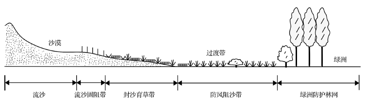
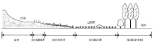
A complete understanding of the transitional zone from oasis to desert was achieved,which had been long-term disputed,based on the abundent accumulation from continuous observation.Cele oasis is chosed as an example to analysis the ecotone from oasis to desert.As a typical type of transitional zone from oasis to desert,the Transitional Zone from Oasis to Sandy Desert can be defined as the desert zone from the edge of oasis(border of artificial protection system or natural sparse shrubs ) to fixed or semi-fixed sandy ground with the vegatation cover between 20%~25% on the outer edge between oasis and mobile desert. The inner boundary of the transitional zone is the artificial protection system on the periphery of oasis,including shelterbelt defending wind and sand or natural sparse shrubbery. The formation of transitional zone is due to the gradient difference of environment factors such as water and temperature that exist from oasis to the outer desert,leading to the transitional feature of the integrated landscape that showed by vegetation,soil and geomorphology,etc. Its composition and structure pattern is sparse shrubs (or shelterbelt system on the edge)-gentle relief ground with bushes and herbs where sand settled-relief ground with bush-herb cones and high relief ground with bush-herb cones in the direction from oasis to desert. The transitional zone is an important region to be retained and protected for native flora and fauna,a buffer zone where energy and material can be transported and exchanged between oasis and desert,and a natural ecological barrier for oasis. It has a protective function on topography,soil and vegetation,and plays an important role in carbon sequestration.
Oases in Ulan Buh Desert can be divided into three function areas, namely oasis eco-economic core area, oasis-desert ecological buffering area and desert ecological restoration area from oasis core to edge. Based on field observation of topography, vegetation, soil, sand disasters and sand sources of different functional areas, a comprehensive control technology system with four parts, which were "fixing shifting-sand zone", " fencing dune for grass recovery zone", "preventing wind and stopping sand zone", and "oasis protection forest network", was proposed to defend the intrusion of shifting sand. An emergency measure system, including engineering and agricultural measures, was proposed to reduce the damage of wind erosion and scattered shifting sand in oases. The study provides a scientific basis for comprehensive control of sand disasters in artificial oases.
Desert Science of China has developed from nonexistence to pass into existence, and from filling a vacancy to getting rapid progress in the past 50 years under the unremitting efforts of several generation researchers. Meantime, Desertification Research has greatly enriched China Desert Science due to its theory progresses on innovation and systematicness, and practical achievements on economic, social and environmental effects, which has made considerable contribution to the national economy construction and eco-environmental protection of northern China; a great group of research achievements were rewarded with awards including National Scientific Progress Special Grade Award etc. and have made hundred millions of direct economic benefit. In the past 20 years, there were 10% percent of desertified lands were reversed, 12% of them were improved, and part of them came forth new phase of "human advances and desert recedes". Up to now, the desert and desertification research institutions on national level that take The Chinese Academy of Sciences and The State Forestry Bureau as the principal parts have come into being, where assembled with many excellent desert and desertification scientists. The relatively complete desert/desertification science system and research system have been established, which have obtained great progress in studies on blown-sand physics and desert environment, desert formation and evolution, global climate change, desertification process and its control, resource environment and sustainable development of desert area, remote sensing and information about desertification; as one result, abundant research original data have been accumulated. Nowadays, a field long-term observation station net has been set up in China desert and desertification areas, they have been providing scientific research achievement and theory bases. The great successes on desert science and practice of China are popularly recognized by local people, government and international science field.
Aeolian geomorphology is formed by wind power in arid, semi-arid, and even humid regions. It is the study of the characteristics of land surface patterns, spatial combinations, formation, and development. Wind regime controls aeolian geomorphology patterns, spatial combinations, and development. Near surface air flow and aeolian flow control the development and movement of dunes. Recently, the field has developed rapidly. This paper summarized recent progress in aeolian geomorphology patterns, wind regime, and dune morphodynamics based on aeolian geomorphology observation methods, analysis method and morphodynamics. The new terrain observation techniques, such as Total Station and three dimensional terrain scanner, provided accuracy terrain data for morphodynamics study. Meanwhile, three dimensional sonic sensor measured high frequency field wind velocity data, which gave more information on the relationship between terrain and near surface air flow. However, the analysis method, such as the relationship between wind regime and dune types, high frequency wind velocity data and reciprocal relationship between dune pattern and near surface air flow, is still not solved.
To study desert-oasis circulation and boundarylayer characteristics in Dunhuang Oasis summer, a set of triple nested numerical simulation experiments with and without the Dunhuang Oasis was conducted, using NCAR nonhydrostatic meso-scale model, MM5V3.6 and the NCEP reanalysed grid data on July 24, 2001.The main results show: The oasis surrounded desert is a cold source in summer.The surface sensitive heat and latent heat fluxes in the oasis are different from its surroundings.In oasis, the sensitiveheat flux is small and latent heat flux is large;but vice versa, in desert.The boundary layer height is low in oasis and high indesert.Oasis could make the unstable stratified atmosphere in desert change to stablein oasis and it changes the circulation and the distribution of temperature and humidity there.The vertical motion is downwards over oasis and upwards over desert, then the air is dry and cold over oasis;warm and moist over desert.There is the wet air colume around oasis, which playsa key role in protecting oasis.It is divergence flow in lower layer over oasis which slow down the desert wind speed in upstream direction of the oasis, but quicken the desert wind speed in downstream direction of the oasis.
The characteristics of specific humidity profile of atmosphere over desert near oasis,observed in HEIFE,are given.And the structure of specific humidity profiles of atmosphere over oasis and desert near it is simulated by a developed mesoscale numerical model of soilplant-atmosphere continuum.In the simulation,inverse humidity of atmosphere over desert near oasis is shown numerically,patterns of three kinds of typical specific humidity profile and law of presence of them are obtained,and the mechanism and physical process,forming the inverse humidity of atmosphere,are explained.
Using the NCAR nonhydrostatic mesoscale model MM5V3.6 and through triple nested technique, we simulated the characteristics of wind field, air temperature and humidity field in Jinta Oasis, middle reaches of Heihe river basin in Hexo Corridor. The main results show that oasis-desert circulation has influence to the local circulation. When dry and hot air in desert is advected to oasis, the inverse temperature phenomenon appears in oasis and sensitive heat flux transports inversely. Because of the vapor advection near oasis, the atmospheric specific humidity in desert is higher and higher from the bottom up. That is the inverse humidity phenomenon.
An observation experiment about water vapour transportation over desert is carried out at desert station in the HEIFE on July 1991 to find the specific humidity profiles often appear minimum in the surface layer.The level of the minimun value is at the height of zero water vapour flux.The water vapour is transported downwards and the profile of specific humidity appears inverse humidity character above the zero flux height,but the vapour is transported upwards and the profile is evaporation character under the zero flux height.The water vapour flux is unconstant in the surface laved at a fixed level,can not represent the evaporativity and the latent heat flux on ground surface.
Lanzhou Institute of Plateau Atmospheric Physics, Chinese Academy of Sciences, Lanzhou Gansu 730000
The characteristics of the surface radiation balance over desert and oasis in HEIFE area were analysed and compared by using the data observed at Desert and Zhangye stations.The results show that ground surface plays an important role on surface radiative energy budget, the non-uniform ground surface leads up to remarkable special variation of surface net radiation in HEIFE atea.Under clear-sky condition, the incoming short-wave and long-wave radiations are nearly equal and have the same diurnal variations over desert and oasis in summer and winter.In summer the differences of net radiation between desert and oasis are caused by the differences of surface albedo and upward long-wave radiation determined by the ground surface and their thermodynamic natures, but in winter the thermodynamic cinditions of ground surface in HEIFE area are nearly the same, so the difference of the surface net radiation betweem desert and oasis is caused by the difference of albedo.Finally, the method for calculating surface net radiation over whole HEIFE area, and the effects of the difference of net radiation between desert and oasis on the micro-climate in HEIFE area are discussed.
1. Cold and Arid Regions Environmental and Engineering Research Institute, Chinese Academy of Sciences, Lanzhou 730000, China; 2. Department of Oceanography, Naval Postgraduate School, Monterey, California 93943, USA
Based on the surface heat and water balance facts in desert and oasis, the equations of atmospheric stability and circulation over the oasis are given.It shows that the main causes that makes oasis surface temperature lower is the obvious great evaporation from the oasis surface.The atmospheric stability over the oasis is an important self-protection mechanism to maintain oasis.From dynamic point of view, obvious downdraft (updraft) over the oasis leads to stabilization (destabilization) of the atmosphere.The albedo effect will reduce the oasis circulation, on the contrary, the evaporation from the oasis can drive the oasis circulation.The excessive evaporation from oasis (than from the desert surface) makes the oasis surface is colder than the surrounding desert surface.The temperature difference between oasis and surrounding desert drives an oasis breeze circulation, in which there is the downdraft over the oasis and the updraft over the desert.
Aerodynamic roughness length z 0m is the basic parameter in research for land surface processes. In this paper, the values of aerodynamic roughness length z 0m were estimated with different surface types in experiment field of Heihe river basin. It could be found that the values of z 0m were rather different between different surfaces, ones in oasis were larger than in desert, especially during canopy growing. With measurements at different height, local and effective roughness length were obtained at same site. Effective roughness length were realistically larger than local ones due to the relationship between the horizontal extent of landscape elements and aerodynamic roughness parameters of total stress at increasing heights. It could be drawn that the horizontal scale thereby aerodynamic roughness length related to had to be determined when one concerned to the research on the parameterization on land surface processes.
地表空气动力学粗糙度是研究水平非均匀条件下陆面过程的基础,文中对黑河试验区各不同下垫面上地表空气动力学粗糙度进行了估算和分析,分别得到了地表空气动力学粗糙度 z 0m 的有效值和局地值,发现各不同典型下垫面的局地 z 0m 值明显不同,尤其在有作物存在时,绿洲的局地 z 0m 值比沙漠、戈壁的值明显要大;而对同一测站,有效空气动力学粗糙度比局地空气动力学粗糙度值明显要大,运用应力分解理论对这种差异进行了解释,认为有效空气动力学粗糙度与复合表面的总应力有关,其代表了较大水平尺度内的表面和较高障碍物的综合作用,当涉及对陆表通量参数化问题时,必须首先确定水平尺度及相应的地表粗糙度参数。
Cold and Arid Regions Environmental and Engineering Research Institute, Chinese Academy of Sciences, Lanzhou 730000, China
Using the NCAR nonhydrostatic mesoscale model MM5V3.6 and triple-nested simulation method, the circulation and boundary layer characteristic over desert and oasis were simulated. The results showed that the oasis-desert circulation and atmospheric boundary layer structure are symmetric without the influence of the background westerly air flow. The desert-oasis changes the circulation structure, temperature and humidity fields of original desert area. The vertical motion is downwards over oasis and upwards over desert, then the air is dry and cold over oasis; but warm and moist over desert. There is the wet air colume around oasis, which plays a key role in protecting the oasis. The oasis-desert circulation and atmospheric boundary layer structure are asymmetric due to the influence of the background westerly air flow. Because of the background westerly air flow, they can break the circulation structure of oasis system symmetry, which is unfavourable for the steady development of oasis system.
Dust devils are unique meteorological phenomena, occurring in the atmosphere boundary layer. Dust devil, usually of short duration, has a low pressure and warm-core, swirling dust, debris, and sand to high levels. This paper reviews the advances of dust devil studies, including the physical characteristics of dust devils and their environmental effect; some results obtained through three kinds of research tools-observation, experiment and numerical simulation; the particle transportation in the air flow field of dust devil and the dust stratification; the electrostatic field by particulate impact. Some aspects are finally summarized for further investigations.
Based on the satellite RS data of sand-dust weather processes and themeteorological observational data from 1980 to 2005, the temporal variation of sand-dusts invading Beijing was analyzed. The source locations and transportationpaths of sand-dusts were determined in assistance with GIS. The results show that sand-dusts in Beijing occurred frequently in the spring and early summer, especially in April. Based on historic statistical data, the annual number of times of sand-dusts in Beijing is in the trend of decreasing in general, but it increased in late 1990s. According to their source locations, the sand-dusts are classified into two types, i.e. the initial-source and enhancive-source locations. The external initial-source locations are in the middle and southeast of Mongolia.The interna1 initial-source locations are in the area near the boundary betweenChina and Mongolia. The interna1 enhancive-source locations are in the desert,gobi and sandy grasslands of middle and west Inner Mongolia, and in the vast reclaimed lands of Hexi Corridor and agro-pastoral ectones of Gansu. There are three transportation paths: north paths, west paths and northwest paths. Most of theexternal source sand-dusts move along the north and northwest paths.
(1. Institute of Desert Meteorology, China Meteorological Administration, Urumqi 830002,Xinjiang, China; 2. Taklimakan Station of Desert Atmosphere and Environment Observation and Experiment, Tazhong 841000, Xinjiang, China; 3. Korla Meteorological Bureau, Korla 841000, Xinjiang, China; 4. Yanqi County Meteorological Bureau, Yanqi 841100, Xinjiang, China)
Aeolian sanddust transport is a serious problem in many arid regions in the world, and it is considered to be as a significant part of global biogeochemical cycle. Deserts are the main sources of nearsurface aeolian sanddust transport, and aeolian sanddust transport process is closely related to the variation of nearsurface horizontal aeolian sanddust flux with height. In this paper, the variation of horizontal aeolian sanddust flux within height 2 m above the ground surface was discussed based on the oneyear observation on a level sand land in the south Taklimakan Desert by BSNE samplers. It was revealed that the horizontal aeolian sanddust flux was decreased with the increase of height, which could be described with the distribution of power function and exponential function. A 55%-58% amount of horizontal aeolian sanddust was transported within an air layer 0.5 m above the ground surface, a 73%-75% amount of that was transported within an air layer 1 m above the ground surface, and a 87%-89% amount of that was transported within 1.5 m above the ground surface. In the study area, the amount of horizontal aeolian sanddust load in a height range from 0 to 2 m was 1 846.7 kg•m -1 , in which the amounts of PM80 and PM50 were 1 192.0 kg•m -1 and 387.9 kg•m -1 respectively.
Minqin in Gansu province of China has being concerned by lots of scholars due to its high dust storm emissions and environmental deterioration. In 2005, the first near surface dust storm observing system in China was founded in this region, and the aims are to monitor the dust storm occurrence, transportation and deposition, supplying the monitoring results the other methods cannot acquired. The system mainly includes three towers (built in desert areas, margins of oasis, and inside the oasis), dust collection instruments and meteorological observing devices. The dust collection instruments mainly include self-collection filter-bags, horizontal collection devices and the instruments for TSP (total suspended particles) instantaneous concentration measures. Preliminary monitoring results on dust occurrence in this region show that the TSP concentration has power function relation with the height; the aerosol concentration in areas of desert and margins of oasis decreases with the increase of height, but increases with height inside the oasis. In addition, the horizontal dust flux also has power function relation with height. The dust concentration decreased by 42.0% from areas of desert to the margins of oasis, and decreased by 74.42% to inside the oasis, which showed high protection function of forest belts in this region.
1. Cold and Arid Regions Environmental and Engineering Research Institute, Chinese Academy of Sciences, Lanzhou 730000, China; 2. Minqin Meteorological Bureau of Gansu Province, Minqin 733300, Gansu Province, China
The temporal characteristics of sandstorm in recent 50 years have been systemically analyzed based on the 1 436 times of sandstorm data observed by Minqin meteorological bureau in this period. According to mechanism of sandstorm-occurring and being linked with other meteorological factors in this area, the relationship between sandstorm and influencing factors has been primarily confirmed. Whether on the times or on the retaining interval of sandstorm-occurring, the general trend of sandstorm-occurring is decreasing, and sandstorms mostly focused on the period from March to April in a year. The research results would supply theoretic gist for controlling sand calamities and rehabilitating ecology of this region.
Soil erosion is an interaction of multi factors including wind, vegetation, soil characteristics, land use, precipitation, micro-geomorphology and so on. It is a continuous dynamic process occurring on airflow-soil interface in the specific geographical locations. Soil erosion empirical model, based on statistic theory, is difficult to avoid overlap of some factors affecting soil wind erosion between sub-models and not enable sub-models to be strictly independent from each other, thereby leading to lack of theoretical basis for modeling. Such empirical model is also not able to objectively reflect dynamic process of soil erosion. On the basis of clarifying basic concepts of soil erosion and analyzing the global research background and inadequacy, we proposed a new theoretical framework for soil erosion models based on wind erosion dynamics theory and the classification as well as representation of factors affecting soil wind erosion under the framework. We also elaborated the rationality of both the framework and the classification as well as the representation of factors affecting soil wind erosion, and further explored the research approaches on the latter.
1. Cele National Station of Observation and Research for Desert-Grassland Ecosystem, Xinjiang Institute of Ecology and Geography, Chinese Academy of Sciences, Urumqi 830011, China; 2. Geographical Science and Tourism College, Xinjiang Normal University, Urumqi 830054, China; 3. University of Chinese Academy of Sciences, Beijing 100049, China
Natural vegetation in desert-oasis ecotone have well effects in preventing and intercepting wind blown sand and have important ecological prevention function for farmland in oasis. On the basis of field observation of wind erosion and wind deposition changes over 1 quadrat of mobile sand land, 1 quadrat of semi-fixed sand land and 4 quadrats of fixed sand land in desert-oasis ecotone in Cele, Xinjiang, China, characteristics of wind erosion and wind deposition changes and its cause over mobile sand land, semi-fixed sand land and fixed sand land were discussed with wind velocity data. Intense wind erosion occurs over surface of mobile sand land; Intense wind deposition occurs over surface of semi-fixed sand land; and the wind deposition volume will be more and wind erosion volume will be fewer in unit area when vegetation coverage and plant height are higher and arrangements pattern of plants are more well-distributed with lower landform as a whole over fixed sand land. Wind erosion mainly occurred on the surfaces of bare low sandy land in upwind and leeward areas and two flanks around nebkhas. The maximum amount of wind erosion always occurs at flank part around high nebkhas. It conforms to polynomial or exponential decreasing function relationship between wind erosion amount and vegetation coverage, and it doesn't follow any function relationship between wind deposition amount and vegetation coverage. Besides for vegetation coverage, kinds, height and arrangement pattern of plants and topography all influence wind deposition amount.
In order to investigate the effects of different soil water content threshold on growth, yield production and irrigation water utility efficiency of muskmelon (Cucumis melo L., Yilishabai variety) in greenhouse, four treatments of soil water content thresholds (I45 with 45% field capacity, I55 with 55% field capacity, I65 with 65% field capacity, I75 with 75% field capacity) were conducted, and a furrow irrigation (G75 with 75% field capacity) as control treatment. The results showed that plant height, stem diameter, leaf area and aboveground biomass decreased with soil water content threshold declined. Values of fruit diameter, pericarp thickness and flesh thickness are the largest for treatment I75, while the index of fruit shape is the least; but the fruit length of I65 is the biggest. As to the fruit quality, total soluble solids (TSS) content ranked as: I65>I55>I75>I45; soluble sugar content ranked as: I55>I65>I45>I75; Vitamin C (Vc) content ranked as: I55>I65>I75>I45; soluble protein content as follows: I55>I65>I45>I75; free amino acid content as follows: I45>I65>I55>I75. The yield and mean fruit weight are highest for I75; the value of water use efficiency for I65 is the highest among the treatments as to 29.16 kg/m3 that is 76.4% higher than that of furrow irrigation (G75), it can save irrigation water 58.1% and the mean fruit weight only declined 3.2% compared with furrow irrigation. Therefore, based on production and quality, 65% field capacity would be the most appropriate thresholds for muskmelon starting irrigation on vegetative growth stage.
Based on previous studies, selecting desert grasslands in the Ulanqab League of the Inner Mongolia as studied area, we carried out a quantitative analysis on influence of vegetation coverage on wind erosion by simulation test with a field mobile wind tunnel, which aimed at discussing the change of aerodynamic roughness and flow structure features under different vegetation coverage, and the quantitative relationship between vegetation coverage and sediment yield. Results show that aerodynamic roughness increases linearly approximately with the increase of vegetation coverage, and linear functional relationship is Z0=ax3+bx2+cx+d. With the increasing of the height above the ground, sediment yield decreases. With the increase of vegetation coverage, sediment yield at each layer also reduces. Under different wind speeds, the relation between sediment yield of wind erosion and vegetation coverage is related by a power function. The conclusion will provide a theory basis for soil and water loss mechanism research.
The threshold condition and mass flux of aeolian sediment transport are the essential quantities for wind erosion prediction, dust storm modeling and geomorphological evolution, as well as the sand control engineering design. As a consequence, they have long been the key issues of windblown sand physics. Early researches on aeolian sediment transport focus mainly on steady transport process. While recently, synchronous, high frequency measurements show that wind field in atmospheric boundary layer is always unsteady, showing up as intense fluctuation of wind speed, which thus results in the intense spatial-temporal variability of aeolian sand transport. It has been proven that unsteady sand/dust transport is closely related with boundary layer turbulence and affects significantly the determination of threshold condition and the prediction of aeolian transport rate. The researches of experiment, theory analysis and numerical simulation on unsteady sand/dust transport in recent two decades are reviewed. Finally, open questions and future developments are suggested.
By sampling along a representative section across the shelterbelt of Baotou-Lanzhou Railway at Shapotou area, grain-size characteristics of aeolian deposits in the shelterbelt and the influences of landform were studied. The total 20 sampling points covered various landform sites such as the windward and leeward slopes of sand dunes, dune crests, and inter-dune depressions.Three of which were located on the surface of a mobile dune at the upwind edge of the shelterbelt, and the other points were located in the straw checkerboard and artificial vegetation belt. The results show that clay and silt contents in surface soil increase greatly and mean grain-size decreases from moving sand area to the artificial vegetational belt due to the changes of the surface properties, and sorting becomes poor. It seems that silt contents decrease with relative height of surface in the shelterbelt; mean grain-size and sorting increase with surface height. Statistics further show that mean grain-size, sorting coefficient and silt content were well linearly related to the relative elevation. Dependence relation between clay content and landform was not observed. The possible cause is that clay material in the deposition was mainly sourced from general dust events. The influence of the landform on dust deposition is very limited. Clay sediments tend to cumulate in the shelterbelt under the protection of the straw checkerboard and artificial vegetation but hardly accumulate in moving sand area due to intensive aeolian activities. Vertically, silt content is high and sorting is poor in the surface 5 cm layer; below this depth silt content decreases and sorting becomes well. The grain-size profile varies among landforms. Estimated aeolian deposition rates around the crest of fixed dunes average 0.147 cm per year, versus more than 0.588 cm on the leeward side and in inter-dune depressions. As a whole, this study revealed the changing regulation of grain-size characteristics along the direction of NNW-SSE in the shelterbelt of Baotou-Lanzhou Railway at Shapotou area, demonstrated the relations between grain-size characteristics and landform, as well as the relations between deposition rates and landform. The results objectively reflected the effects of the landform on aeolian deposition in the shelterbelt.
This paper,through the characteristic analysis of sediment grain-size, discuss the grain-size parameters,the frequency distributions of grain-size, the response diagram of mean grain-size to sorting and their spatial relations. The sand samples studied are collected from the oases in the southern margin of the Taklimakan Desert. The aims are to make clear the properties of sand materials and the condition of wind action, to analyse the movement of blown sand and the formation of blown sand landforms, thus laying a basis for building the protective system of oases.
1. Qira Station for Desert Steppe Ecosystem Research and Observation, Xinjiang Institute of Ecology and Geography, Chinese Academy of Sciences, Urumqi 830011, China; 2. University of Chinese Academy of Sciences, Beijing 100049, China
Field measurement of wind direction at 200 cm high and wind velocity at five heights (20 cm, 40 cm, 60 cm, 100 cm and 200 cm) over three typical plots, with plant coverage of < 5%, 10%-15% and 20%-25% respectively, was conducted in the Qira desert-oasis ecotone. The purpose of this research is to help to understand the characteristics of wind fluctuation over different ground surface at the southern rim of the Taklimakan Desert. It is concluded that the vegetation type affects the change of average wind velocity, wind velocity fluctuation and wind direction fluctuation, but it has little influence on probability distribution of wind velocity fluctuation. With increasing plants density, the change range of average wind velocity and absolute wind velocity fluctuation decrease. The absolute wind velocity fluctuation increases with increase of wind velocity and with increase of height to ground surface in all three plots. Affected by plant community structure, the relative wind velocity fluctuation becomes complicated. The range of wind direction fluctuation increases with plants density, but it has no obvious change in the same plot when wind velocity changes.
The sand particle concentration profile of wind blown sand in the saltation layer results from the interaction between wind and sand particles, and precise sand particle concentration profile can help to clarify the feed-back mechanism of wind-sand interactions and interactions between sand particles. Based on a special distribution function of sand particles' initial lift-off velocity and a physical model for the sand particles that moving in the wind flow, the trajectories of sand particles that in the steady state wind-sand flow are numerically calculated by fourth order Adams-Bashforth-Moulton method, and the sand particle concentration profiles are analyzed. The results indicate that the sand particle concentration profiles are directly and closely relevant with wind velocity and sand particle diameters and are exponentially or Gamma distributed with height. Interestingly, it will increase with the increase of the sand particle diameter and decrease with the increase of the shear velocity at any particular height.
Based on experiment and the description of fluctuating wind field by Langevin equation, the characteristics of saltating grains as well as the windblown sand cloud have been discussed. The numerical simulations demonstrate that the fluctuating wind field exerts a great influence on saltation of grains, and the smaller the grain size is, the greater the influence would be. Moreover, the windblown sand cloud in the fluctuating wind field also shows a stratified characteristic and the mass fluxes agree well with the previous experiments.
In order to continuously monitor the sand-dust aerosol concentration in Minqin,a dust source area in China,a monitoring system was set up in 2005.The characteristics of the sandstorm-aerosol concentrations near the surface were determined from January to December 2006.The results showed that the concentration of aerosols in spring was the highest with an average value of 14.61 mg·m -3 ,It reduced gradually to 12.49 mg·m -3 in summer.There was no sandstorm in fall and the average concentration was 9.82 mg·m -3 in winter.The sandstorm-aerosol concentration increased proportionally with the sandstorm intensity: the average concentration for strong,middle,and weaker sandstorms was 18.80,13.56,and 3.07 mg·m -3 respectively.The sandstorm-aerosols concentration dropped sharply from desert to oasis and the corresponding concentrations were 21.07,12.09,and 6.49 mg·m -3 in desert,at the edge of desert and oasis,and in oasis,respectively.Regardless of the type of ground cover,sandstorm-aerosol concentration reduced in power function with height.The range of the sandstorm-aerosol concentrations in the high-frequency season was larger than that in the low-frequency season.The sandstorm-aerosol concentrations were almost the same above a height of 41 m,regardless of the ground cover,indicating that the effects of different ground cover were only apparent to a height of 40 m in the Minqin area.
以民勤绿洲-荒漠交错带活化沙丘上的植物群落为对象,研究了活化沙丘不同部位的沙地植物群落物种组成、结构和多样性的变化.研究结果表明:从活化沙丘的下部、中部、丘顶,到背风坡的中部、下部,再到丘间低地,每一个生境对应着不同的群落类型.各部位不仅植物种类和数量存在差异,而且群落结构差异明显,其中丘顶为一年生草本植被构成,而丘间低地处只有灌木.群落物种多样性与相似性指数表明,从沙丘下部到丘顶再到丘间地,生态因子的差异对物种的分布格局产生了影响,从而导致了群落结构和功能发生了变化.活化沙丘植被简单,退化严重,需加强保护,防止继续退化. Abstract: The vegetation communities of activating dune in the Minqin oasis-desert ecotone were investigated by a conventional way for researching the plant species structures and characteristics in different position of the dune. The results showed that there is a different plant community type in each position of the activating dune from low,midst,dune tops and midst, low of slope depressions and sandy land among the dunes. The differences of plant species and quantity had exist, also the variance of plant communities obviously. There is only annual grass species on dune tops, but shrubs on sandy land. The bio-diversity and the similarity index of communities showed that the differenee of ecological factors not only affected the distribution patterns of species, but also changed the structures and functions of plant communities. The vegetations of these activating sanddunes are simple and suffer degeneration serious, then need enhanced protection methods to prevent sand dunes from becoming mobile.
1.College of Resources and Environment Science, Xinjiang University, Urumqi 830046, China; 2.Key Laboratory of Oasis Ecology, Xinjiang University Urumqi 830046, China
Driving forces to the changes of arable land is one of important issues for LUCC (land use/cover change) research nowadays. The driving forces can be classified into two kinds: natural or human factors. Yutian country is located in the south of the Tarim Basin, and belongs to the extreme arid desert climate. Most social-economic activities occurred in the oasis region, but the oasis area is unceasingly reducing. In order to keep a sustainable development of economy, the protection of the arable land is very important in this region. The authors firstly have a look back to the dynamic change of arable land from 1949 to 2004 in Yutian Oasis, then analyze the driving forces to the change of arable land from two natural and human aspects. The results indicate that the natural factor is a basic restriction in the long-term development of oasis, and social-economical factor is a main factor in the short-term development. If the human activities are conformable to the natural the oasis area will enlarge, otherwise the oasis area will reduce.
The desertificaton and its control in the northern part of the Linze Oasis were studied. The results indicated that the degradation of the oasis ecosystem is mainly due to the imbalance between the fragile ecosystem and the human's unwise overuse, which triggers and worsens such natural factors as paucity of precipitation, abundance of sand materials and sparseness of vegetation. However, control and reversion of desertification in this area is possible and can be speeded-up artificially when we have a sound understanding of its causation and adopt correct ways to establish and maintain an integrative protection system, which consists of the shelterbelt networks in the farmlands, the sand controlling forest belts along the periphery of the oasis, different types of sand fixing forests, vegetation protecting belts, sand barriers, irrigation system and agri-culural techniques for sand controlling. Through the above approaches for only 15 years, desertification in this area has been controlled and reversed. Not only has the oasis not suffered from sand and drought disasters, but the abandoned desertified land has been recultivated largely, and a stable oasis ecosystem with high productivity formed. Strategies in increasing the stability of the oasis protection system were discussed also.
 , 安志山, 蔡迪文, 郭紫晨, 王军战]