中国近海海洋锋和锋面预报研究进展
任诗鹤, 王辉*, 刘娜
国家海洋环境预报中心 国家海洋局海洋灾害预报技术研究重点实验室,北京100081
*通讯作者:王辉(1962-),男,安徽濉溪人,研究员,主要从事海洋预报理论与方法、业务化海洋学和海洋动力学研究. E-mail: wangh@nmefc.gov.cn

作者简介:任诗鹤(1986-),男,河北唐山人,研究实习员,主要从事海洋数值预报模拟研究.E-mail:rensh@nmefc.gov.cn

摘要

海洋锋是水文要素特性不同的2个水团之间的狭窄过渡带,是一种重要的中尺度海洋现象,对渔业、军事和海洋环境保护等许多领域有重要影响,已经成为近年来物理海洋学以及海洋交叉学科中的重要课题之一。中国近海由于众多环流、水团和涡旋在此交汇,海洋锋现象十分显著,近年来,我国学者对中国近海的海洋锋产生机制和变化规律取得了一定的进展。首先从实测水文资料分析、遥感资料分析和数值模拟3个方面分别回顾了黄海、东海、南海北部等中国近海海域海洋锋的研究进展。对于海洋锋的预报研究,我国起步较晚,但目前对近海海洋锋预报的需求十分迫切。回顾总结了国外海洋锋预报的进展,集中介绍了黑潮锋、冰岛—法罗群岛锋、湾流锋和墨西哥湾锋面涡旋的预报方法和现状,最后对如何开展中国近海海洋锋预报提出思考和展望。

关键词: 海洋锋; 锋面预报; 中国近海
中图分类号:P731.1 文献标志码:A 文章编号:1001-8166(2015)05-0552-12
Review of Ocean Front in Chinese Marginal Seas and Frontal Forecasting
Ren Shihe, Wang Hui, Liu Na
Key Laboratory of Research on Marine Hazards Forecasting, National Marine Environmental Forecasting Center, Beijing, 100081, China
Abstract

Ocean front is transition zone between two water mass with different hydrological features. Ocean front is an important mesoscale phenomenon, which has important significances in various fields, such as fishery, environment protection and marine military defense. Thus, ocean front becomes one of the key points in the physical oceanography and also in the inter-disciplinary studies. In Chinese marginal seas, ocean front is very importrant because of complex situation of water mass, circulation and eddies. In recent years, researchers have studied the distribution characteristics and the dynamic mechanism of fronts in Chinese marginal seas based on in-situ hydrographic data, remote sensing satellite data, theoretical analysis and numerical model. In this paper, we review the progress of fronts in the Yellow Sea, East China Sea and the northern part of South China Sea. In our country, the research on frontal forecasting is still in the beginning stage, but forecast of ocean front is strongly demanded in China. Progress about forecasting of Kuroshio front, Gulf Stream front, frontal eddies in Gulf of Mexico and Iceland-Faeroe front is introduced in this paper. In addition, some thoughts and prospects about developing frontal forecast system in Chinese marginal seas are presented.

Keyword: Ocean front; Frontal forecasting; Chinese marginal seas.
1 引言

海洋锋是性质不同的2个或几个水团之间的狭窄过渡带, 可用某一特定的水文特征, 如温度、盐度、密度、颜色、叶绿素等要素的水平梯度来描述[1], 其空间尺度小至几米, 大至上千公里, 时间尺度短至几天, 有些海洋锋甚至常年稳定存在。海洋锋对渔业、军事和海洋环境保护等许多领域有重要影响。

海洋锋区内局地平流和垂直运动加强, 导致锋区内营养盐等物质富集[2], 在锋面附近的水团中, 浮游植物十分丰富, 从而为浮游生物提供充足的饵料。海洋锋区的强度与渔获量的关系十分密切, 常与重要的渔场分布相一致[3~5]。例如中国的舟山渔场和闽南渔场存在较强的海洋锋。对锋面这类海洋中尺度现象的理解和预测对海洋军事也有巨大的价值, 包括战术安排、航线设计、海上搜救等均需要考虑海洋锋的影响。由于锋面影响海洋内部的物理过程对声波在海洋中的传播有很大的影响, 所以锋面是海洋军事必须考虑的重要问题[6]。海洋锋的研究在海洋环境保护方面也起到了很重要的作用, 锋区常常伴有海水的辐合, 能将浮游碎屑、油污和重金属等物质聚集在锋带附近[7]。对海洋锋面研究也成为海洋交叉学科研究中的一个重要课题[8]

随着卫星技术和数值模式的不断发展, 大量的全球范围表层海洋遥感实时资料, 结合日益成熟的高时空分辨率的数值模式结果和大范围的现场观测数据, 对全球海洋锋的时空变化和演变机制的研究逐渐成为物理海洋学研究的热点之一。中国近海众多环流、水团和涡旋在此交汇, 海洋锋现象十分显著, 我国学者也逐渐认识到认识和揭示锋面物理过程的重要性, 近年来对中国近海的海洋锋的产生机制以及其分布和变化规律也取得了一定的进展[9~11]。但对海洋锋这类中尺度现象的预报研究起步较晚, 全球范围内来看, 海洋锋预报研究目前主要集中在大西洋沿岸海域。

2 中国近海海洋锋的研究现状

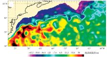
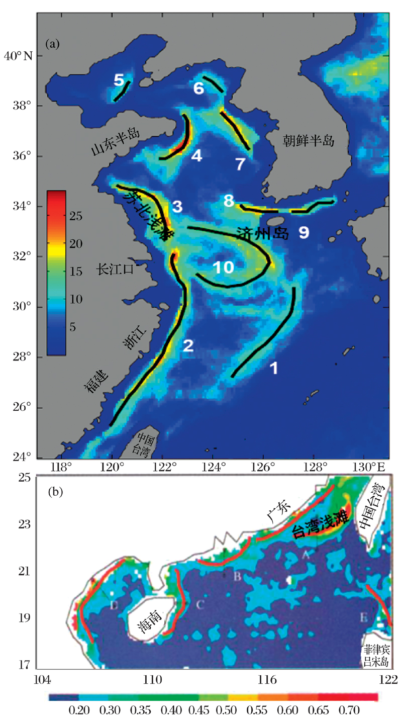
整个中国近海海域在季风、河流径流、海底地形以及海表热通量的相互作用下, 环流结构十分复杂[12~17], 产生了性质相对独立的不同水团, 为锋面的形成和发展提供了有利条件。Hickox等[12]和Wang等[13]利用长时间卫星遥感海表温度(Sea Surface Temperature, SST)数据, 通过计算锋面出现频率的方法, 给出了黄海、东海和南海北部主要锋面的大致分布位置(图1a和1b), 并通过锋面强度等特征, 分析了各锋面的季节变化规律。从整体上看, 中国近海的海洋锋位置比较固定, 但受季风影响大多数海温锋面具有季节性变化, 冬季锋面强度偏大, 分布较广; 而夏季由于整个海区的海温升高掩盖了海表温度锋面的形成, 由对流产生的海温锋面基本消失, 仅在沿岸地区和浅滩边缘存在由潮汐混合和地形共同作用产生的温度锋面。后文将从实测水文资料分析、遥感资料分析和数值模拟3个方面分别回顾黄海、东海、南海北部等中国近海海域海洋锋的研究进展。

图 1 基于长时间序列卫星遥感SST数据得到的黄、东海(a)[12]和南海北部(b)[13]海洋锋出现频率分布图Fig.1 Frontal probability maps in the Yellow Sea and East China Sea (a) [12] and the South China Sea (b)[13] base on long-term satellite remote-sensing SST data

2.1 黄海

黄海是位于大陆架上的一个半封闭的浅海。黄海海洋锋大体分为2类, 一类主要是冬半年因冷暖平流辅聚形成的海洋锋, 另一类主要形成于春夏季, 是由强垂向湍流混合引起的潮汐锋[18]

黄海暖流作为冬季黄海环流的主要组成部分, 是一支向黄海和渤海输送高温高盐水的海流[19~23]。黄海暖流和南下的黄海沿岸冷水相遇会导致锋面的产生[24, 25]。郑义芳等[26]和Ning等[27]通过卫星数据描述了一个从南黄海中部开始沿苏北浅滩和长江浅滩边缘向东南方向延伸直至东海的狭长锋面, 称为黄海暖流锋面。He等[28]通过卫星遥感SST数据发现, 济州岛西部存在一个东西向的温度锋面, 长江河口外围边缘也存在一个环状锋面。Park等[14]通过数值模拟的结果认为, 这2处的锋面呈S状相连。在夏季, 黄海一个显著的特点就是在黄海中部的海底存在一个低温水团— 黄海底层冷水团[29], 黄海冷水团环流几乎控制着整个黄海海域, 锋面在冷水团的边缘形成, 在潮汐的搅拌混合作用下, 近岸一侧的混合区和离岸一侧的层化区之间形成锋面[23, 25, 30]。赵保仁[31, 32]利用现场水文调查资料和卫星遥感图像探讨了夏季黄海潮汐锋现象, 并参考Simpson等[33]用于划分层化和混合区界限的层化参量 P=lg(H/U3), (其中H代表水深, U代表潮流整层平均振幅)较为明确地给出了黄海和东海北部夏季表层温度锋的位置。其中较明显的锋区包括山东半岛东部、渤海海峡东侧、朝鲜江华湾西部海域、朝鲜半岛西南岸的木浦外海和苏北浅滩等区域。针对黄海潮汐锋的数值模拟已有较多研究, 戚建华等[34]利用一个三维环流模式的模拟证明了潮流的混合作用是维持黄海夏季海洋锋的重要因子。Liu等[35]基于三维近岸环流模型对黄海M2分潮、密度环流和锋区环流等进行了数值模拟, 对2个断面锋区环流的模拟结果显示锋区对应的上升流特征与锋区表面观测到的冷水现象吻合。Ma等[36]通过一个波浪— 潮汐的三维环流模式分析认为影响黄海西部的潮汐锋的主要因素是潮汐引起的垂直混合、垂直对流作用和经向平流导致。Ren等[37]也通过数值模拟比较了潮汐混合和潮致上升流对黄海夏季潮汐锋的不同作用。Moon等[25]还通过对风和潮汐的一系列数值实验证明了冬季影响黄海环流和锋面过程的主要动力因子是风, 而夏季潮汐则是影响黄海锋面的主导因素。

2.2 东海

东海海洋锋的种类较丰富, 有沿岸锋、陆架锋和陆坡锋。东海的锋面季节变化十分显著:冬季海表锋面的宽度和强度达到最强, 主要锋面有浙闽沿岸锋和黑潮锋[38]; 夏季受海区升温影响, 掩盖了大部分锋面的形成, 表层温度锋仅出现在长江口附近。现场观测是比较早的海洋锋研究手段, 汤毓祥[39, 40]依据多年的东海水文观测资料, 较为系统地总结了东海海洋锋面的类型, 分析了黑潮锋和浙闽沿岸锋位置的季节变化。He等[28]利用卫星SST和高度计资料也大致确定了东海的几个主要锋区, 分别是黑潮锋区、浙江沿岸锋区和长江河口锋区。Ning等[27]用卫星遥感水色和SST资料结合现场实测资料, 分析了东海水团和锋面分布的大体结构, 并指出SST资料更适合对冬季黄东海水温的区域变化较大的情况下水团和锋面的区分和识别, 而在夏秋季水温分布较为均匀的情况下, 水色数据能够更好的用于确定锋面。Yuan等[17, 41, 42]利用MODIS(Moderate Resolution Imaging Spectroradiometer)叶绿素浓度a和卫星SST数据首次发现了夏秋之交的浙闽外海的跨陆架穿刺锋面, 并通过模式结果证实了的确存在此类锋面, 还发现了叶绿素浓度锋与温度锋在空间分布上不一致的情况。

2.3 南海北部

和东海锋面特征类似, 季风系统引起的沿岸流锋面的季节变化是南海北部锋面的主要特点。由于多种水系在此交汇, 加上季风的作用, 海域的流系结构相当复杂, 浙闽沿岸水、粤东沿岸水、南海暖流水、黑潮入侵水等不同流系在不同季节的相互作用, 导致了南海北部海洋锋的季节变化。陈俊昌[43]最早尝试应用红外卫星云图对南海北部冬季海洋锋进行了分析。Wang等[13]利用多年月平均卫星遥感SST资料, 通过计算锋面出现频率的方法分析了南海北部的几条主要锋面的分布位置和季节变化情况。Chu等[44]用美国海军的GDEM(Generalized Digital Environmental Model)气候态数据集分析了南海锋面的季节变化, 指出了南海北部陆架区沿越南东岸到吕宋岛一线存在一条锋面, 锋面的最大梯度位置出现在次表层50 m深, 并且伴随着一支跨越海盆的海流, 沿着这条海流的中尺度涡旋也比较丰富。王磊[45]对南海北部陆架海洋锋区域的锋面涡旋现象进行了初步的分析和讨论, 指出了黑潮流套的入侵可能是南海北部1999年冬季观测到的“ 猫眼” 式涡旋结构的可能原因。

台湾海峡作为连接东海与南海的狭窄水道, 主要受以下因素影响:季风、浙闽沿岸流、上升流和南海暖流等。复杂的动力机制及多变的地形导致了台湾海峡附近海域存在复杂的海洋锋结构[46~49]。夏季对台湾海峡海洋锋影响最大的是上升流。肖晖等[50~52]通过多次对福建广东沿岸和台湾海峡海域海洋综合调查的实测水文资料, 发现了夏季台湾浅滩附近存在较强的上升流锋面。许多学者也通过卫星遥感的SST和水色资料发现了台湾海峡的上升流锋面[53~55], 台湾浅滩的上升流锋面一年四季基本上均稳定存在, 而粤东外海的上升流锋面则主要出现在夏季。李立等[56]结合卫星和历史水文资料, 对台湾海峡南部海域的海洋锋现象进行了分析表明, 受季风气候影响, 锋面分布有显著的季节差异:夏季主要以上升流锋面为主, 而冬季则主要是浙闽沿岸流锋面。Chang等[57]也利用卫星遥感资料分析了冬季台湾海峡内的浙闽沿岸锋。

3 海洋锋预报的研究现状

目前对于中国近海的锋面预报研究还比较少, 主要集中在黑潮锋的预报, 国际上对于锋面预报的工作主要包括湾流锋、墨西哥湾的锋面涡旋和北欧海的冰岛— 法罗群岛锋, 这些研究可为中国近海锋面预报研究以及预报系统的建立和发展提供一些借鉴和参考。

3.1 黑潮锋

黑潮锋是东海最重要的水文特征之一。前人关于黑潮锋的研究主要包括黑潮锋的分布特征、变化规律、次级环流结构等[58~63]。林传兰[58]分析了东海黑潮锋的海洋学特征, 并发现东海黑潮锋是一支常年稳定存在的中等强度海洋锋, 兼具西边界流锋和陆坡锋的特点。郭炳火等[10]指出东海北部海区黑潮锋位置存在季节变化, 锋面结构受陆架水系季节层化的重大影响, 其季节差异明显, 冬、夏季锋区位置存在几十公里的变动。除了季节变化之外, 我国学者还指出了黑潮流轴存在着短周期性的震荡, 而黑潮路径的变化会导致黑潮锋出现波动特征[10, 28, 35, 60, 63~66]。一系列现场调查以及数值模拟分析的结果也指出黑潮次表层水的涌升、地转流量和长江径流量是影响黑潮锋位置变化的重要因素[59~61, 63]。尽管直接对黑潮锋的预报研究比较少, 但黑潮的位置变化会直接影响黑潮对陆架的入侵程度, 因而影响黑潮锋的位置。目前针对黑潮路径的预报工作也有很多, 特别是对于日本以南的黑潮大弯曲的预报。Komori等[67]用一个1.5层的原始方程模式建立一个短期的黑潮路径预报系统, 该系统对黑潮流轴位置的预报取得了不错的效果, 预报时效长达75天。Kamachi等[68]研发了一个基于更加复杂的海洋环流模式的预报系统, 并于2001年在日本气象厅(Japan Meteorological Agency)实现了业务化运行, 取得了较好的预报效果。Kagimoto等[69]基于POM(Princeton Ocean Model)开发了一个高分辨率(10 km)的预报系统, 该系统成功地对2003— 2004年的黑潮大弯曲路径变化进行了预报。

3.2 湾流锋

和黑潮一样, 湾流是西北大西洋一支强劲的西边界流, 来自热带的高温高盐水向高纬度侵入而形成一个斜压性很强的锋面, 湾流的弯曲及其流轴的变化, 经常导致锋面斜压结构和位置的变化[1, 70]。对于湾流锋的预报, 最早开始的是美国海军, 对锋面这类海洋中的“ 天气” 现象的理解和预测对军事作战有重大的意义, 包括战术安排, 航线设计, 海上搜救等等。国外建立的全球和区域涡分辨率实时预报系统能够实现对海洋锋的预报。

从2000年开始, 美国海军基于水平分辨率为1/16° 的分层海洋环流模式(NRL Layered Ocean Model, NLOM)建立了第一代全球海洋的涡分辨的实时的即时预报/预报系统[71], 该系统采用了最优插值(Optimal Interpolation, OI)同化方法, 主要用于同化SST和SLA(Sea Level Anomaly)数据, 并且每周进行一次30天的预报。该预报系统于2006年将分辨率由1/16° 提升到1/32° , 模式的动力过程和设置也做了优化[72]。对该预报系统一个很重要的评估就是对全球范围内主要的锋面和涡旋位置的即时预报[73]。美国海军下属的作战支持中心(Warfighting Support Center, WSC)主要依靠红外波段的卫星SST资料对锋面进行定位并向舰队发布海洋锋分析产品, 但红外波段的卫星图像受云层的干扰很大, 当前对湾流锋的预报也主要是针对湾流主流轴位置的预报, 所以对湾流锋面预报来说, 海表高度(Sea Surface Height, SSH)往往是比SST更好的指标。WSC采用了NLOM每天的SSH预报结果作为另外一个重要的工具改进分析产品的准确度, 另外NLOM提供SSH的动画可以更好的追踪锋面和中尺度涡的移动路径, 帮助作战中心提供空间和时间上更完整的锋面预报产品。图2显示了NLOM的预报结果和WSC的锋面分析结果(白色实线), 证明了系统对湾流锋具有较好的预报能力。

目前, 美国海军所采用的全球预报系统基于混合坐标海洋模式HYCOM(Hybrid Coordinate Ocean Model)的水平分辨率是1/12° , 使用的同化方法是三维多变量最优插值, 今后几年业务化系统将会采用三维变分数据同化方法(Three- dimensional Variational Analysis, 3DVAR), 模式水平分辨率也将提升至1/25° , 将会对海洋锋和中尺度涡这类中小尺度过程有更好的预报效果[74]。模式也对湾流锋面的预报结果进行了评估, 模式后报的SSH结果显示预报的锋面位置和独立观测SST分析的锋面位置基本吻合。

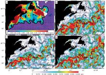
法国的Mercator中心基于NEMO(Nucleus for European Models of the Ocean)模式建立了水平分辨率为1/12° 的全球海洋预报系统, 该系统对湾流锋面预报水平进行了评估。图3是Mercator预报系统对湾流流速10天的预报结果。图3b~d分别显示了大西洋-地中海区域预报系统(分辨率1/12° )和全球预报系统(分辨率为1/4° 和1/12° )对湾流锋面的预报结果。图3a显示的是由水色遥感资料得到的锋面位置, 可以看出Mercator预报结果中的锋面强流区能够很好的和MODIS的水色锋面相对应[75]

3.3 墨西哥湾锋面涡旋

湾流在向北流动的过程中进入墨西哥湾后其路径会弯曲形成一个流环(Loop Current), 然后从佛罗里达海峡流出墨西哥湾重新汇入湾流主流系[76]。湾流流环形成过程中, 会产生许多中尺度涡旋从流环中脱落下来, 并不断向西发展, 而在涡旋的外围常常伴随锋面的形成[77, 78]。而且湾流流环的路径经常发生变化, 涡旋脱落的过程也伴随着很强的非线性作用, 因此锋面涡旋的过程很难预报出来。随着模式的分辨率的不断提高, 近些年也有许多关于对墨西哥湾锋面涡旋的预报和研究工作。

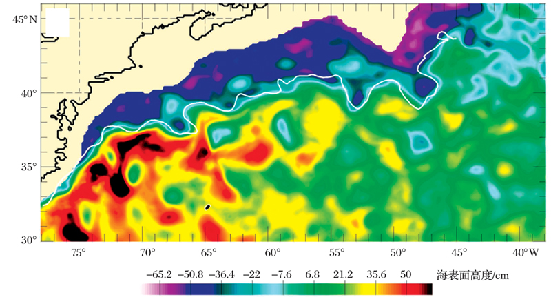
图2 2001年6月11日NLOM全球1/16° 系统对湾流区域SSH即时预报结果(色标)[73]图中叠加了WSC的独立锋面分析结果(白色实线)Fig.2 SSH analysis in the Gulf Stream region from the real-time 1⁄16° global NLOM for June 11, 2001[73]Superimposed on this figure is independent Gulf Stream frontal analysis determined from WSC (white lines) for the same days

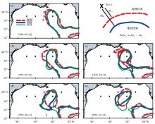
Oey等[77]采用基于POM模式的PROFS(Princeton Regional Ocean Forecast System)预报系统对湾流流环和锋面涡旋的位置进行了试验性的预报, 其主要针对2000年8~9月的一次涡旋脱落过程进行后报试验, 过程中同化了卫星高度计资料和卫星海表温度资料。锋面位置的后报试验能够很好的预报出一个很强的涡旋脱落并向西南方向移动的过程(图4), 还指出了预报误差主要来源于初始场。Yin等[79]采用孵化集合预报(bred-ensemble forecast, BEnF)方法构建一系列初始场对锋面涡旋的位置和强度得到的集合预报结果比传统的单一初始场预报更接近观测结果。挪威的TOPAZ(Towards an Operational Prediction system for the North Atlantic European coastal Zones)预报系统用HYCOM模式选取10个样本对墨西哥湾锋面涡旋进行了集合预报[80], 其中初始场集合样本的选取是通过选取不同的同化参数实现的。7天的集合预报结果显示, 集合预报的结果和水色资料以及卫星高度计显示的锋面位置都比较接近, 而且集合预报也能够很好的重现和预报墨西哥湾中尺度涡Eddy Yankee的脱落过程。Gopalakrishnan 等[81]通过伴随(四维变分同化)方法在较长的时间窗口内通过调整初始场、边界条件和大气强迫场不断的将模式结果向观测逼近, 从而得到一个动力协调的初始场, 再用这个初始场继续进行预报, 结果显示预报水平要明显高于持续性预报和初始场选用HYCOM再分析结果的控制试验预报。

3.4 冰岛— 法罗群岛锋

冰岛— 法罗群岛锋(Iceland-Faroe Front, IFF)存在于冰岛— 苏格兰海脊的上方, 是高温高盐的北大西洋水团和低温低盐的北极水团的分界面, 这个区域常常伴随着强流速和强温度梯度[82~84]。由于渔业作为北欧海周边国家的支柱经济产业之一, 受海洋锋的影响十分显著, 所以对北欧海锋面系统, 特别是对冰岛— 法罗群岛锋位置的预报有重要的意义。

从20世纪70年代末开始, 观测就揭示出IFF区域的复杂的锋面和涡旋演变过程, 指出了IFF的锋面弯曲的空间尺度为10~40 km, 时间尺度约为几天[85]。如此小的空间和时间尺度对锋面的预报提出了很大的挑战。Miller等[82, 86]利用一个准地转(Quasi-Geostrophic, QG)模型以1992年10月航次的实测水文数据作为初始场对IFF冷舌入侵的快速增长过程进行了预报, 证明了QG模型对IFF的变化具有一定的预报能力, 并指出了斜压不稳定机制是影响IFF变化的重要因素。1993年8月大西洋最高联合司令部水下研究中心(Supreme Allied Commander Atlantic Undersea Research Center)和哈佛大学第一次采用原始方程模式以业务化运行模式实现了在船舶上对冰岛— 法罗群岛锋的实时预报[87]。预报过程采用最优插值同化方案得到7天的预报结果, 其中预报的初始场、分析场更新和验证所需的数据都来自于实时的船舶观测。结果显示模式能够对冰岛和法罗群岛之间强烈的中尺度弯曲和锋面涡旋系统的剧烈快速的变化准确的进行预报, 预报和观测的相关系数和均方根误差(RMSE)都明显强于持续性预报。21世纪初, 对IFF的实时预报又扩展到海洋生物领域, 哈佛大学海洋预测系统(Harvard Ocean Prediction System, HOPS)采用一个物理和生物过程耦合的三维海洋模式针对2001年6月的一次锋面演变过程在船舶上进行了实时预报, 成功的预报出反气旋弯曲的锋面过程和由此产生的上层海洋初级生产力的聚集[83]

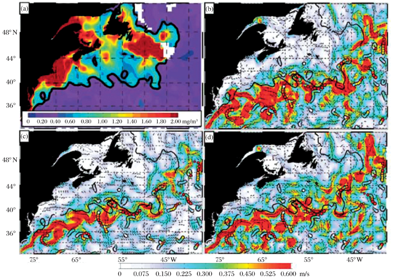
图3 Mercator中心不同分辨率的全球和区域预报系统对湾流锋面的预报[75](a)2008年4月26日MODIS(Moderate Resolution Imaging Spectroradiometer)水色遥感资料的叶绿素a浓度; 黑色实线代表0.5 mg/m3等值线, 用来代表湾流锋面位置; (b~d)Mercator系统10天的流速预报; (b)大西洋— 地中海区域预报系统(分辨率1/12° ), (c)全球预报系统(分辨率1/4° )和(d)全球预报系统(分辨率1/12° ).(b~d)全部叠加(a)中的黑色实线Fig.3 Gulf Stream frontal forecasting of different horizontal resolution global and regional forecast system in Mercator[75](a) Chlorophyll-a concentration from Moderate Resolution Imaging Spectroradiometer(MODIS) on April 26, 2008. The thick black line is the 0.5 mg/m3 contour, which tends to follow the Gulf Stream front. (b~d) 10-day ocean current velocities forecasts on April 26, 2008, from three Mercator Ocean prediction systems, (b) Atlantic and Mediterranean system(1/12° ), (c)global system(1/4° ), and (d)global system(1/12° ), (b~d)all overlaid with the black line from (a)

4 展望

当前社会、经济和军事等各个行业对海洋环境信息需求日益迫切, 促使着海洋预报技术的不断发展, 也为我国海洋预报提出了更高的要求和挑战。未来我国的业务化海洋预报系统分辨率和预报精度将需要继续提高, 还要加强对海洋可预报性的研究, 改进海洋预报系统、提高预报技巧[88]。当前目前国内外海洋预报机构对海洋环境要素的预报涉及从天气尺度到气候尺度的多种海洋过程和现象, 包括全球和区域的短期海温、海流的业务化预报产品[89, 90]。未来海洋预报要素也将从基本的温盐流扩展到中尺度涡、锋面和跃层等中小尺度海洋物理现象, 我国的海洋预报部门未来将重点关注对海洋锋、中尺度涡等中尺度现象的诊断预报技术研究和预报试验, 为渔业、海洋军事等领域提供精细化的产品和预报保障服务。发展针对中国近海中尺度过程的预报系统将重点关注以下3个方面:数值模式、观测系统和资料同化方案。

4.1 发展高分辨率海洋模式

三维海洋环流模式是海洋预报系统的核心, 对于像中尺度涡和锋面这类海洋“ 天气” 现象, 模式分辨率是一个重要的影响因素, 只有当模式的水平分辨率小于或等于局地第一斜压罗斯贝变形半径, 模式才能分辨出中尺度涡旋和锋面, 这样的模式称为涡旋识别模式[91]。目前国家海洋环境预报中心的中国近海区域业务化预报系统分辨率已经达到了1/30° , 西北太平洋预报系统的分辨率也达到了1/20° , 已经具备涡旋识别的分辨率[92]。今后还将在局部海域发展更加精细的区域模式, 可以对一些空间尺度更小的次级中尺度涡和锋面进行模拟研究。中国近海从南到北跨40个纬度, Rossby变形半径差异巨大, 层结季节变化大, 对斜压Rossby变形半径影响更大, 在发展精细区域模式时应该依此考虑模型分辨率的设置。

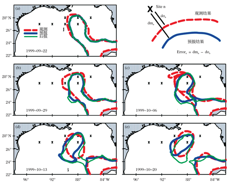
图4 墨西哥湾流绕流锋面位置以及中尺度涡脱落过程[77]1999年9月22日至10月20日期间, 墨西哥湾流绕流锋面位置以及中尺度涡脱落情况的比较, 红色曲线为观测, 蓝色曲线为预报, 绿色曲线为后报结果; “ X” 为固定观测站; 右上图为观测与预报锋面间最小距离的计算示意图Fig.4 Frontal positions and the shedding of eddy from Loop Current[77]Comparison of frontal positions and the shedding of eddy from Loop Current for Sep/22-Oct/20/1999, red line is observed, blue line is forecast and green line is hindcast. Crosses “ X” show the fix observation sites. Inset on top right shows schematics of observed and forecast fronts

模式物理过程的参数化方案的优化对于改进中尺度现象的预报也是至关重要的。中国近海区域地形复杂, 又处在季风控制区域, 对于不同的海区的环流主导因素也有所不同, 影响锋面和中尺度涡过程的关键参数化方案包括:侧向混合参数化、垂向混合参数化、潮汐、径流和短波辐射参数化等。对中尺度过程的预报来说, 模式对这些参数化过程方案的选取具有很强的敏感性, 需要进行大量的模拟实验和检验评估。

通过回顾国外对锋面预报的研究现状可以看出, 一个准确而且动力协调的初始场对于中尺度现象的预报是至关重要的。目前针对区域海洋模拟, Gangopadhyay等[93]提出了一种面向特征(Feature-oriented)的初始化方法, 这种方法的核心思想是将影响研究区域的重要中尺度环流结构和演变过程的历史信息考虑进来, 包括不同时空尺度的海洋现象的相互作用。这样得到的初始场不但在动力上是协调的, 而且包含了研究区域的各种尺度的环流信息。目前这种方法对湾流大弯曲[94]、墨西哥湾流环的锋面涡旋[78]、美国西海岸的加利福尼亚流系[95]以及东海岸的乔治浅滩[96]都进行了预报试验, 得到的结果也都被证明是有效的。对于中国近海的锋面来说, 东海黑潮锋面的特点和湾流类似, 都属于强西边界流锋面, 而南海环流和墨西哥湾类似, 都是由其内部的中尺度涡旋主导, 在今后对中国近海中尺度预报系统的研制和改进过程中也可以考虑采用这种方法改善初始场, 提高预报能力。

4.2 海洋观测系统

虽然现在海洋观测迅速发展, 但还是不能满足业务化海洋预报的需求, 特别对于中尺度过程的预报, 更高时空分辨率的观测是至关重要的。随着我国综合国力不断提升, 目前对海洋观测的投入迅速增加, 但如何更好的规划海洋观测系统成为了亟待解决的问题。海洋观测系统实验(Observing System Experiment, OSE)和海洋观测系统模拟实验(Observing System Simulation Experiment, OSSE)可以对观测系统进行合理的规划设计, OSE和OSSE不但能够得到最优观测方案, 还能对模式参数的设置方案提供科学的理论依据[97~101]

4.3 资料同化方案

海洋中的多源观测数据越来越丰富, 从传统的船舶观测和沿岸水文站观测到现在大量的卫星遥感和浮(潜)标等观测, 将获得前所未有的海量海洋资料, 资料同化系统的作用就是从这些海量的资料中将所需要的信息提取融合、通过将大量的现场和卫星遥感资料同化到海洋环流模式中, 可以有效减少模式误差, 为海洋数值预报提供好的初始场, 改进预报效果[102, 103]

目前海洋资料同化常用方法根据其理论原理可分为2类, 一类是基于统计估计理论的, 如集合最优插值(Ensemble Optimal Interpolation, EnOI)、集合Kalman滤波(Ensemble Kalman Filter, EnKF)等; 另外一类是基于变分方法的, 如三维变分(3DVAR)和四维变分(4DVAR)[104~110]。在海洋业务预报过程中, 资料同化不但要考虑到同化效果, 还要考虑计算资源和预报时效问题, 因此目前国际上主流的海洋预报系统主要采用的是三维变分和集合同化方法。随着高性能计算机的不断发展, 更加合理的四维变分资料同化方法可能会成为未来业务预报中主要的同化方法。

The authors have declared that no competing interests exist.

参考文献
[1] Belkin I M, Cornillon P C, Sherman K. Fronts in large marine ecosystems[J]. Progress in Oceanography, 2009, 81(1/4): 223-236. [本文引用:2] [JCR: 3.708]
[2] Bost C A, Cotte C, Bailleul F, et al. The importance of oceanographic fronts to marine birds and mammals of the southern oceans[J]. Journal of Marine Systems, 2009, 78(3): 363-376. [本文引用:1] [JCR: 2.655]
[3] Pan Yuqiu, Cao Xinzhong, Xu Jianping. A preliminary investigation of the cause and characteristics of the upwelling front zone off Zhejiang[J]. Transactions of Oceanology and Limnology, 1982, 3: 1-7.
[潘玉球, 曹欣中, 许建平. 浙江沿岸上升流锋区特征及其成因的初步探讨[J]. 海洋湖沼通报, 1982, 3: 1-7. ] [本文引用:1] [CJCR: 0.464]
[4] Ning Xiuren, Liu Zilin, Cai Yuming. A review on primary production studies for China seas in the past 20 years[J]. Donghai Marine Science, 2000, 18(3): 13-20.
[宁修仁, 刘子琳, 蔡昱明. 我国海洋初级生产力研究二十年[J]. 东海海洋, 2000, 18(3): 13-20. ] [本文引用:1]
[5] Wang Wenyu, Shao Quanqin, Xue Yunchuan, et al. On the relationship between the resources of ommastrephes bartrami and marine environment in the Northwest Pacific Ocean based on GIS[J]. Geo-Information Science, 2003, 1: 39-44.
[王文宇, 邵全琴, 薛允传, . 西北太平洋柔鱼资源与海洋环境的 GIS 空间分析[J]. 地球信息科学, 2003, 1: 39-44. ] [本文引用:1] [CJCR: 0.681]
[6] Burnett W, Harper S, Preller R, et al. Overview of operational ocean forecasting in the US Navy: Past, present and future[J]. Oceanography, 2014, 27(3): 24-31. [本文引用:1] [JCR: 2.701]
[7] Wei Qinsheng, Xin’gang, Wang Zongxing, et al. The preliminary analysis on the characteristics of the continental shelf front and its ecological effects in the Yellow sea[J]. Advances in Earth Science, 2010, 25(4): 435-443.
[韦钦胜, 吕新刚, 王宗兴, . 黄海陆架锋特征及其生态效应的初步分析[J]. 地球科学进展, 2010, 25(4): 435-443. ] [本文引用:1] [CJCR: 1.388]
[8] Liu Baoyin, Zhang Jie. A new frontier area for Marine Science-“Digital Ocean”[J]. Geo-Information Science, 2000, 1: 8-11.
[刘宝银, 张杰. 海洋科学的前沿——“数字海洋”[J]. 地球信息科学, 2000, 1: 8-11. ] [本文引用:1] [CJCR: 0.681]
[9] Zhao Baoren. A preliminary study of continental shelf fronts in the western part of Southern Huanghai Sea and circulation structure in the front region of the Huanghai Cold Water Mass (HCWM)[J]. Oceanologia et Limnologia Sinica, 1987, 18(3): 217-226.
[赵保仁. 南黄海西部的陆架锋及冷水团锋区环流结构的初步研究[J]. 海洋与湖沼, 1987, 18(3): 217-226. ] [本文引用:1] [CJCR: 1.344]
[10] Guo Binghuo, Wan Bangjun. Wavelike features and evolution of the oceanic fronts in the East China Sea[J]. Journal of Oceanograpgy of Huanghai & Bohai Seas, 1995, 13(2): 1-10.
[郭炳火, 万邦君. 东海海洋锋的波动及演变特征[J]. 黄渤海海洋, 1995, 13(2): 1-10. ] [本文引用:2]
[11] Huang Weigen, Lin Chuanlan, Lou Xiulin, et al. Satellite observations of the thermal front in the Taiwan Strait and its adjacent seas[J]. Acta Oceanologica Sinica, 2006, 28(4): 49-55.
[黄韦艮, 林传兰, 楼塄林, . 台湾海峡及其邻近海域海面温度锋的卫星遥感观测[J]. 海洋学报, 2006, 28(4): 49-55. ] [本文引用:1] [CJCR: 0.915]
[12] Hickox R, Belkin I, Cornillon P, et al. Climatology and seasonal variability of ocean fronts in the east China, Yellow and Bohai Seas from satellite SST data[J]. Geophysical Research Letters, 2000, 27(18): 2 945-2 948. [本文引用:2] [JCR: 3.982]
[13] Wang D X, Liu Y, Qi Y Q, et al. Seasonal variability of thermal fronts in the northern South China Sea from satellite data[J]. Geophysical Research Letters, 2001, 28(20): 3 963-3 966. [本文引用:2] [JCR: 3.982]
[14] Park S, Chu P C. Thermal and haline fronts in the Yellow/East China Seas: Surface and subsurface seasonality comparison[J]. Journal of Oceanography, 2006, 62(5): 617-638. [本文引用:1] [JCR: 1.051]
[15] Yuan D L, Zhu J R, Li C Y, et al. Cross-shelf circulation in the Yellow and East China Seas indicated by MODIS satellite observations[J]. Journal of Marine Systems, 2008, 70(1/2): 134-149. [本文引用:1] [JCR: 2.655]
[16] Chen C T. Chemical and physical fronts in the Bohai, Yellow and East China seas[J]. Journal of Marine Systems, 2009, 78(3): 394-410. [本文引用:1] [JCR: 2.655]
[17] Yuan D L, Hsueh Y. Dynamics of the cross-shelf circulation in the Yellow and East China Seas in winter[J]. Deep-Sea Research Part I: Topical Studies in Oceanography, 2010, 57(19/20): 1 745-1 761. [本文引用:2]
[18] Liu Chuanyu. Distribution and Variations of the Thermal Fronts in the Eastern China Seas[D]. Qingdao: Institute of Oceanology, China Academy of Sciences, 2009.
[刘传玉. 中国东部近海温度锋面的分布特征和变化规律[D]. 青岛: 中国科学院海洋研究所, 2009. ] [本文引用:1]
[19] Mask A C, O’Brien J J, Preller R. Wind-driven effects on the Yellow Sea Warm Current[J]. Journal of Geophysical Research—Oceans, 1998, 103(C13): 30 713-30 729. [本文引用:1]
[20] Riedlinger S K, Jacobs G A. Study of the dynamics of wind-driven transports into the Yellow Sea during winter[J]. Journal of Geophysical Research—Oceans, 2000, 105(C12): 28 695-28 708. [本文引用:1]
[21] Ichikawa H, Beardsley R C. The current system in the Yellow and East China Seas[J]. Journal of Oceanography, 2002, 58(1): 77-92. [本文引用:1] [JCR: 1.051]
[22] Ma J, Qiao F L, Xia C S, et al. Effects of the Yellow Sea Warm Current on the winter temperature distribution in a numerical model[J]. Journal of Geophysical Research—Oceans, 2006, 111: C11S04, doi: DOI:10.1029/2005JC003171. [本文引用:1]
[23] Xia C S, Qiao F L, Yang Y Z, et al. Three-dimensional structure of the summertime circulation in the Yellow Sea from a wave-tide-circulation coupled model[J]. Journal of Geophysical Research—Oceans, 2006, 111: C11S03, doi: DOI:10.1029/2005JC003218. [本文引用:2]
[24] Lie H J, Cho C H, Lee S. Tongue-shaped frontal structure and warm water intrusion in the southern Yellow Sea in winter[J]. Journal of Geophysical Research—Oceans, 2009, 114: C01003, doi: DOI:10.1029/2007JC004683. [本文引用:1]
[25] Moon J H, Hirose N, Yoon J H. Comparison of wind and tidal contributions to seasonal circulation of the Yellow Sea[J]. Journal of Geophysical Research—Oceans, 2009, 114: C08016, doi: DOI:10.1029/2009JC005314. [本文引用:3]
[26] Zheng Yifang, Ding Liangmo, Tan Duo. Distribution characteristics of marine fronts in the southern Huanghai Sea and the Donghai Sea[J]. Journal of Oceanography of Huanghai & Bohai Seas, 1985, 5(1): 9-17.
[郑义芳, 丁良模, 谭铎. 黄海南部及东海海洋锋的特征[J]. 黄渤海海洋, 1985, 5(1): 9-17. ] [本文引用:1]
[27] Ning X, Liu Z, Cai Y, et al. Physicobiological oceanographic remote sensing of the East China Sea: Satellite and in situ observations[J]. Journal of Geophysical Research—Oceans, 1998, 103(C10): 21 623-21 635. [本文引用:2]
[28] He M, Chen G, Sugimori Y. Investigation of mesoscale fronts, eddies and upwelling in the China Seas with satellite data[J]. The Global Atmosphere and Ocean System, 1995, 3(4): 273-288. [本文引用:3]
[29] Su Jilan, Huang Daji. On the current field associated with the Yellow Sea Cold Water Mass[J]. Oceanologia et Limnologia Sinica, 1995, 26(5): 1-7.
[苏纪兰, 黄大吉. 黄海冷水团的环流结构[J]. 海洋与湖沼, 1995, 26(5): 1-7. ] [本文引用:1] [CJCR: 1.344]
[30] Lu X G, Qiao F L, Xia C S, et al. Upwelling and surface cold patches in the Yellow Sea in summer: Effects of tidal mixing on the vertical circulation[J]. Continental Shelf Research, 2010, 30(6): 620-632. [本文引用:1] [JCR: 1.889]
[31] Zhao Baoren. The fronts of the Huanghai Cold Water Mass (HCWM) induced by tidal mixing[J]. Chinese Journal of Oceanology and Limnology, 1985, 16(6): 451-460.
[赵保仁. 黄海冷水团锋面与潮混合[J]. 海洋与湖沼, 1985, 16(6): 451-460. ] [本文引用:1] [JCR: 0.577] [CJCR: 0.3746]
[32] Zhao Baoren. The continental shelf fronts induced by tidal mixing in the Huanghai Sea[J]. Journal of Oceanography of Huanghai & Bohai Seas, 1987, 5(2): 16-23.
[赵保仁. 黄海潮生陆架锋的分布[J]. 黄渤海海洋, 1987, 5(2): 16-23. ] [本文引用:1]
[33] Simpson J, Hunter J. Fronts in the Irish Sea[J]. Nature, 1974, 250: 404-406. [本文引用:1] [JCR: 38.597]
[34] Qi Jianhua, Su Yusong. The numerical research on the tidal shelf front in the Yellow Sea[J]. Oceanologia et Limnologia Sinica, 1998, 29(3): 247-254.
[戚建华, 苏育嵩. 黄海潮生陆架锋的数值模拟研究[J]. 海洋与湖沼, 1998, 29(3): 247-254. ] [本文引用:1] [CJCR: 1.344]
[35] Liu G, Wang H, Sun S, et al. Numerical study on the velocity structure around tidal fronts in the Yellow Sea[J]. Advances in Atmospheric Sciences, 2003, 20(3): 453-460. [本文引用:2] [JCR: 1.338] [CJCR: 0.9244]
[36] Ma J, Qiao F, Xia C, et al. Tidal effects on temperature front in the Yellow Sea[J]. Chinese Journal of Oceanology and Limnology, 2004, 22(3): 314-321. [本文引用:1] [JCR: 0.577] [CJCR: 0.3746]
[37] Ren S, Xie J, Zhu J. The roles of different mechanisms related to the tide-induced fronts in the Yellow Sea in summer[J]. Advances in Atmospheric Sciences, 2014, 31(5): 1 079-1 089. [本文引用:1] [JCR: 1.338] [CJCR: 0.9244]
[38] Hu Xiaomin. A Study of Tempo-spatial Distribution Features of Fronts in the Seas East of China and Dynamical Diagnosis of Fronts along the Western Boundary of Kuroshio[D]. Qingdao: Ocean University of China, 2013.
[胡筱敏. 中国东部海域海洋锋时空分布特征及黑潮西锋区动力学诊断研究[D]. 青岛: 中国海洋大学, 2013. ] [本文引用:1]
[39] Tang Yuxiang. Preliminary study on classification of oceanic fronts in East China Sea[J]. Journal of Oceanograpgy of Huanghai & Bohai Seas, 1995, 13(2): 16-22.
[汤毓祥. 东海海洋锋分类的初步探讨[J]. 黄渤海海洋, 1995, 13(2): 16-22. ] [本文引用:1]
[40] Tang Yuxiang. Distributional features and seasonal variations of temperature fronts in the East China Sea[J]. Oceanologia et Limnologia Sinica, 1996, 27(4): 436-444.
[汤毓祥. 东海温度锋的分布特征及其季节变异[J]. 海洋与湖沼, 1996, 27(4): 436-444. ] [本文引用:1] [CJCR: 1.344]
[41] Yuan D L, Qiao F L, Su J. Cross-shelf penetrating fronts off the southeast coast of China observed by MODIS[J]. Geophysical Research Letters, 2005, 32: L19603, doi: DOI:10.1029/2005GL023815. [本文引用:1] [JCR: 3.982]
[42] Yuan D L, Li Y, He L, et al. An observation of the three-dimensional structure of a cross-shelf penetrating front off the Changjiang mouth[J]. Deep-Sea Research Part II: Topical Studies in Oceanography, 2010, 57(19/20): 1 827-1 834. [本文引用:1] [JCR: 2.243]
[43] Chen Junchang. Some explanation of sea surface temperature distribution in northern South China Sea in winter[J]. Acta Oceanologica Sinica, 1983, 5(3): 391-395.
[陈俊昌. 南海北部冬季海面温度实时分布特征的若干解译[J]. 海洋学报, 1983, 5(3): 391-395. ] [本文引用:1] [CJCR: 0.915]
[44] Chu P C, Wang G H. Seasonal variability of thermohaline front in the central South China Sea[J]. Journal of Oceanography, 2003, 59(1): 65-78. [本文引用:1] [JCR: 1.051]
[45] Wang Lei. A Study of Fronts and Frontal Eddies in the Northern Shelf Region of the South China Sea[D]. Qingdao: Ocean University of China, 2004.
[王磊. 南海北部陆架区域的海洋锋及锋面涡旋研究[D]. 青岛: 中国海洋大学, 2004. ] [本文引用:1]
[46] Jan S, Wang J, Chern C S, et al. Seasonal variation of the circulation in the Taiwan Strait[J]. Journal of Marine Systems, 2002, 35(3/4): 249-268. [本文引用:1] [JCR: 2.655]
[47] Tang D, Kester D R, Ni I H, et al. Upwelling in the Taiwan Strait during the summer monsoon detected by satellite and shipboard measurements[J]. Remote Sensing of Environment, 2002, 83(3): 457-471. [本文引用:1] [JCR: 5.103]
[48] Hu J, Kawamura H, Hong H, et al. A review of research on the upwelling in the Taiwan Strait[J]. Bulletin of Marine Science, 2003, 73(3): 605-628. [本文引用:1] [JCR: 1.297]
[49] Jiang Y, Chai F, Wan Z, et al. Characteristics and mechanisms of the upwelling in the southern Taiwan Strait: A three-dimensional numerical model study[J]. Journal of Oceanography, 2011, 67(6): 699-708. [本文引用:1] [JCR: 1.051]
[50] Xiao Hui. Studies of coastal upwelling in western Taiwan Strait[J]. Journal of Oceanography in Taiwan Strait, 1988, 7(2): 135-142.
[肖晖. 台湾海峡西部沿岸上升流的研究[J]. 台湾海峡, 1988, 7(2): 135-142. ] [本文引用:1] [CJCR: 0.612]
[51] Xiao Hui, Cai Shuhui. Distribution characters of sea temperature and salinity in western Taiwan Strait[J]. Journal of Oceanography in Taiwan Strait, 1988, 7(3): 227-234.
[肖晖, 蔡淑惠. 台湾海峡西部海域温、盐度分布特征[J]. 台湾海峡, 1988, 7(3): 227-234. ] [本文引用:1] [CJCR: 0.612]
[52] Xiao Hui, Guo Xiaogang. Summarization of studies on hydrographic characteristics in Taiwan Strait[J]. Journal of Oceanography in Taiwan Strait, 2002, 21(1): 126-138.
[肖晖, 郭小钢. 台湾海峡水文特征研究概述[J]. 台湾海峡, 2002, 21(1): 126-138. ] [本文引用:1] [CJCR: 0.612]
[53] Lan K W, Kawamura H, Lee M A, et al. Summertime sea surface temperature fronts associated with upwelling around the Taiwan Bank[J]. Continental Shelf Research, 2009, 29(7): 903-910. [本文引用:1] [JCR: 1.889]
[54] Pi Q, Hu J. Analysis of sea surface temperature fronts in the Taiwan Strait and its adjacent area using an advanced edge detection method[J]. Science in China (Series D), 2010, 53(7): 1 008-1 016. [本文引用:1]
[55] Zhang F, Li X, Hu J, et al. Summertime sea surface temperature and salinity fronts in the southern Taiwan Strait[J]. International Journal of Remote Sensing, 2014, 35(11/12): 4 452-4 466. [本文引用:1]
[56] Li Li, Guo Xiaogang. Oceanic fronts in southern Taiwan Strait[J]. Journal of Oceanography in Taiwan Strait, 2000, 19(2): 147-156.
[李立, 郭小钢. 台湾海峡南部的海洋锋[J]. 台湾海峡, 2000, 19(2): 147-156. ] [本文引用:1] [CJCR: 0.612]
[57] Chang Y, Shieh W J, Lee M A, et al. Fine-scale sea surface temperature fronts in wintertime in the northern South China Sea[J]. International Journal of Remote Sensing, 2010, 31(17/18): 4 807-4 818. [本文引用:1]
[58] Lin Chuanlan. Oceanographic characteristics of the Kuroshio Front in the East China Sea and the relationship with fisheries[J]. Donghai Marine Science, 1986, 4(2): 8-16.
[林传兰. 东海黑潮锋的海洋学特征及其与渔场的关系[J]. 东海海洋, 1986, 4(2): 8-16. ] [本文引用:2]
[59] Zheng Yifang, Tan Duo. Ocean fronts and thermocline in East China Sea[C]∥Kuroshio Research Papers (I). Beijing: China Ocean Press, 1987.
[郑义芳, 谭铎. 东海海洋锋和跃层现象[C]∥黑潮调查研究论文集(一). 北京: 海洋出版社, 1987. ] [本文引用:1]
[60] Sugimoto T, Kimura S, Miyaji K. Meand er of the Kuroshio front and current variability in the East China Sea[J]. Journal of the Oceanographical Society of Japan, 1988, 44(3): 125-135. [本文引用:1]
[61] Wong G T, Pai S C, Liu K K, et al. Variability of the chemical hydrography at the frontal region between the East China Sea and the Kuroshio north-east of Taiwan[J]. Estuarine, Coastal and Shelf Science, 1991, 33(2): 105-120. [本文引用:1] [JCR: 2.324]
[62] Wan Bangjun, Tang Yuxiang, Guo Binghuo. Preliminary analysis on the feature of ocean front in the northeast part of the East China Sea[C]∥Kuroshio Research Papers (IV). Beijing: China Ocean Press, 1992.
[万邦君, 汤毓祥, 郭炳火. 东海东北部海洋锋特征的初步分析[C]∥黑潮调查研究论文选 (四). 北京: 海洋出版社, 1992. ] [本文引用:1]
[63] James C, Wimbush M, Ichikawa H. Kuroshio meand ers in the East China Sea[J]. Journal of Physical Oceanography, 1999, 29(2): 259-272. [本文引用:3] [JCR: 3.179]
[64] Qiu B, Toda T, Imasato N. On Kuroshio front fluctuations in the East-China-Sea using satellite and insitu observational data[J]. Journal of Geophysical Research—Oceans, 1990, 95(C10): 18 191-18 204. [本文引用:1]
[65] Zheng Yifang, Tang Yuxiang, Huang Weimin. Short period change of fronts in East China Sea[C]∥Kuroshio Research Papers (III). Beijing: China Ocean Press, 1991.
[郑义芳, 汤毓祥, 黄卫民. 东海北部黑潮锋的短周期变动及其两侧海况的变化[C]∥黑潮调查研究论文选(三). 北京: 海洋出版社, 1991. ] [本文引用:1]
[66] Zhang D, Lee T N, Johns W E, et al. The Kuroshio east of Taiwan: Modes of variability and relationship to interior ocean mesoscale eddies[J]. Journal of Physical Oceanography, 2001, 31(4): 1 054-1 074. [本文引用:1] [JCR: 3.179]
[67] Komori N, Awaji T, Ishikawa Y, et al. Short-range forecast experiments of the Kuroshio path variabilities south of Japan using TOPEX/Poseidon altimetric data[J]. Journal of Geophysical Research: Oceans, 2003, 108(C1): 3 010. [本文引用:1]
[68] Kamachi M, Kuragano T, Ichikawa H, et al. Operational data assimilation system for the Kuroshio south of Japan: Ranalysis and validation[J]. Journal of Oceanography, 2004, 60(2): 303-312. [本文引用:1] [JCR: 1.051]
[69] Kagimoto T, Miyazawa Y, Guo X, et al. High resolution Kuroshio forecast system: Description and its applications[M]∥High Resolution Numerical Modelling of the Atmosphere and Ocean. Yokohama, Japan: Springer, 2008: 209-239. [本文引用:1]
[70] Lee T N, Atkinson L P, Legeckis R. Observations of a Gulf Stream frontal eddy on the Georgia continental shelf, April 1977[J]. Deep-Sea Research Part I: Oceanographic Research Papers, 1981, 28(4): 347-378. [本文引用:1] [JCR: 2.816]
[71] Smedstad O M, Hurlburt H E, Metzger E J, et al. An operational eddy resolving 1/16 global ocean nowcast/forecast system[J]. Journal of Marine Systems, 2003, 40: 341-361. [本文引用:1] [JCR: 2.655]
[72] Shriver J F, Hurlburt H E, Smedstad O M, et al. 1/32°real-time global ocean prediction and value-added over 1/16°resolution[J]. Journal of Marine Systems, 2007, 65(1/4): 3-26. [本文引用:1] [JCR: 2.655]
[73] Rhodes R C, Hurlburt H E, Wallcraft A J, et al. Navy real-time global modeling systems[J]. Oceanography, 2002, 15(1): 29-43. [本文引用:1] [JCR: 2.701]
[74] Chassignet E P, Hurlburt H E, Metzger E J, et al. US GODAE: Global ocean prediction with the Hybrid Coordinate Ocean Model (HYCOM)[J]. Oceanography, 2009, 22(2): 64-75. [本文引用:1] [JCR: 2.701]
[75] Hurlburt H E, Brassington G B, Drillet Y, et al. High-resolution global and basin-scale ocean analyses and forecasts[J]. Oceanography, 2009, 22(3): 110-127. [本文引用:1] [JCR: 2.701]
[76] Oey L Y, Ezer T, Lee H C. Loop Current, rings and related circulation in the Gulf of Mexico: A review of numerical models and future challenges[J]. Circulation in the Gulf of Mexico: Observations and Models, 2005, doi: DOI:10.1029/161gm04. [本文引用:1]
[77] Oey L Y, Ezer T, Forristall G, et al. An exercise in forecasting loop current and eddy frontal positions in the Gulf of Mexico[J]. Geophysical Research Letters, 2005, 32(12), doi: DOI:10.1029/200GL023253. [本文引用:2] [JCR: 3.982]
[78] Frolov S A, Rothstein L M. Feature modeling approach to simulating loop current frontal eddies[J]. Estuarine, Coastal and Shelf Science, 2006, 70(4): 533-540. [本文引用:2] [JCR: 2.324]
[79] Yin X Q, Oey L Y. Bred-ensemble ocean forecast of Loop Current and rings[J]. Ocean Modelling, 2007, 17(4): 300-326. [本文引用:1] [JCR: 2.628]
[80] Counillon F, Bertino L. High-resolution ensemble forecasting for the Gulf of Mexico eddies and fronts[J]. Ocean Dynamics, 2009, 59(1): 83-95. [本文引用:1] [JCR: 1.761]
[81] Gopalakrishnan G, Cornuelle B D, Hoteit I, et al. State estimates and forecasts of the loop current in the Gulf of Mexico using the MITgcm and its adjoint[J]. Journal of Geophysical Research: Oceans, 2013, 118(7): 3 292-3 314. [本文引用:1]
[82] Miller A J, Poulain P M, Warn-Varnas A, et al. Quasigeostrophic forecasting and physical processes of Iceland -Faroe frontal variability[J]. Journal of Physical Oceanography, 1995, 25(6): 1 273-1 295. [本文引用:2] [JCR: 3.179]
[83] Popova E E, Srokosz M A, Smeed D A. Real-time forecasting of biological and physical dynamics at the Iceland -Faeroes Front in June2001[J]. Geophysical Research Letters, 2002, 29(4): 14-1-14-4. [本文引用:1]
[84] Liang X S, Robinson A R. A study of the Iceland -Faeroe frontal variability using the multiscale energy and vorticity analysis[J]. Journal of Physical Oceanography, 2004, 34(12): 2 571-2 591. [本文引用:1] [JCR: 3.179]
[85] Hansen B, Meincke J. Eddies and meand ers in the Iceland -Faroe Ridge area[J]. Deep-Sea Research Part I: Oceanographic Research Papers, 1979, 26(9): 1 067-1 082. [本文引用:1] [JCR: 2.816]
[86] Miller A J, Poulain P M, Robinson A R, et al. Quantitative skill of quasi-geostrophic forecasts of a baroclinically unstable Iceland -Faroe Front[J]. Journal of Geophysical Research: Oceans, 1995, 100(C6): 10 833-10 849. [本文引用:1]
[87] Robinson A R, Arango H, Leslie W, et al. Real-time operational forecasting on shipboard of the Iceland -Faeroe frontal variability[J]. Bulletin of the American Meteorological Society, 1996, 77(2): 243-259. [本文引用:1] [JCR: 6.591]
[88] Wang Hui, Liu Na, Li Benxia, et al. An overview of ocean predictability and ocean ensemble forecast[J]. Advances in Earth Science, 2014, 29(11): 1 212-1 225.
[王辉, 刘娜, 李本霞, . 海洋可预报性和集合预报研究综述[J]. 地球科学进展, 2014, 29(11): 1 212-1 225. ] [本文引用:1] [CJCR: 1.388]
[89] Wang H. Operational Oceanography Forecasting System in Developing Countries[R]. Baltimore, Maryland : GODAE Ocean View Symposium, 2013. [本文引用:1]
[90] Zhang Binjian. Chinese Global Operational Oceanography Forecasting System is Officially Issued[N]. China Ocean News, 2013 -10-18.
[张斌键. 全球业务化海洋学预报系统正式运行[N]. 中国海洋报, 2013 -10-18. ] [本文引用:1]
[91] Semtner A J, Chervin R M. Ocean general circulation from a global eddy-resolving model[J]. Journal of Geophysical Research: Oceans, 1992, 97(C4): 5 493-5 550. [本文引用:1]
[92] Wang H.  GOVST-III Meeting Presentations: China-NMEFC[R]. Paris: The 3rd Meeting of the GODAE Ocean View Science Team, 2011. [本文引用:1]
[93] Gangopadhyay A, Robinson A, Arango H. Circulation and dynamics of the western North Atlantic. Part I: Multiscale feature models[J]. Journal of Atmospheric and Oceanic Technology, 1997, 14(6): 1 314-1 332. [本文引用:1] [JCR: 1.693]
[94] Gangopadhyay A, Robinson A. Circulation and dynamics of the western North Atlantic. Part III: Forecasting the meand ers and rings[J]. Journal of Atmospheric and Oceanic Technology, 1997, 14(6): 1 352-1 365. [本文引用:1] [JCR: 1.693]
[95] Gangopadhyay A, Lermusiaux P F, Rosenfeld L, et al. The California Current System: A multiscale overview and the development of a Feature-Oriented Regional Modeling System (FORMS)[J]. Dynamics of Atmospheres and Oceans, 2011, 52(1): 131-169. [本文引用:1] [JCR: 1.734]
[96] Gangopadhyay A, Robinson A R, Haley P J, et al. Feature-oriented regional modeling and simulations in the Gulf of Maine and Georges Bank[J]. Continental Shelf Research, 2003, 23(3): 317-353. [本文引用:1] [JCR: 1.889]
[97] Hirschi J, Baehr J, Marotzke J, et al. A monitoring design for the Atlantic meridional overturning circulation[J]. Geophysical Research Letters, 2003, 30(7): 1 413. [本文引用:1] [JCR: 3.982]
[98] Schiller A, Wijffels S E, Meyers G A. Design requirements for an Argo float array in the Indian Ocean inferred from observing system simulation experiments[J]. Journal of Atmospheric and Oceanic Technology, 2004, 21(10): 1 598-1 620. [本文引用:1] [JCR: 1.693]
[99] Sakov P, Oke P R. Objective array design: Application to the tropical Indian Ocean[J]. Journal of Atmospheric and Oceanic Technology, 2008, 25(5): 794-807. [本文引用:1] [JCR: 1.693]
[100] Xue P F, Chen C S, Beardsley R C, et al. Observing system simulation experiments with ensemble Kalman filters in Nantucket Sound, Massachusetts[J]. Journal of Geophysical Research—Oceans, 2011, 116: C01011, doi: DOI:10.1029/2010JC006428. [本文引用:1]
[101] Xue P F, Chen C S, Beardsley R C. Observing system simulation experiments of dissolved oxygen monitoring in Massachusetts Bay[J]. Journal of Geophysical Research—Oceans, 2012, 117: C05014, doi: DOI:10.1029/2011JC007843. [本文引用:1]
[102] Bouttier F, Courtier P. Data Assimilation concepts and methods March 1999[Z]∥Meteorological Training Course Lecture Series Reading. ECMWF, 2002. [本文引用:1]
[103] Cummings J A. Operational multivariate ocean data assimilation[J]. Quarterly Journal of the Royal Meteorological Society, 2005, 131(613): 3 583-3 604. [本文引用:1] [JCR: 3.327]
[104] Counillon F, Bertino L. Ensemble optimal interpolation: Multivariate properties in the Gulf of Mexico[J]. Tellus Series A, 2009, 61(2): 296-308. [本文引用:1] [JCR: 2.736]
[105] Li Hong, Xu Jianping. Development of data assimilation and its application in ocean science[J]. Marine Science Bulletin, 2011, 30(4): 463-472.
[李宏, 许建平. 资料同化技术的发展及其在海洋科学中的应用[J]. 海洋通报, 2011, 30(4): 463-472. ] [本文引用:1] [CJCR: 0.674]
[106] Han Pei, Shu Hong, Xu Jianhui. A comparative study of background error covariance localization in EnKF data assimilation[J]. Advances in Earth Science, 2014, 29(10): 1 175-1 185.
[韩培, 舒红, 许剑辉. EnKF同化的背景误差协方差矩阵局地化对比研究[J]. 地球科学进展, 2014, 29(10): 1 175-1 185. ] [本文引用:1] [CJCR: 1.388]
[107] Qiao Fangli. The unification and application reviews of modern oceanic/atmospheric data assimilation algorithms[J]. Advances in Marine Science, 2002, 20(4): 79-93.
[乔方利. 现代海洋/大气资料同化方法的统一性及其应用进展[J]. 海洋科学进展, 2002, 20(4): 79-93. ] [本文引用:1] [CJCR: 0.669]
[108] Zhang Aizhong, Qi Linlin, Ji Fei, et al. Advancement in data assimilation method research[J]. Meteorological Science and Technology, 2006, 33(5): 385-389.
[张爱忠, 齐琳琳, 纪飞, . 资料同化方法研究进展[J]. 气象科技, 2006, 33(5): 385-389. ] [本文引用:1] [CJCR: 1.0338]
[109] He Na, Zhang Zuqiang, Xiao Xianjun, et al. Advancement in application to satellite data assimilation in the ocean circulation model[J]. Marine Sciences, 2008, 32(12): 92-96.
[何娜, 张祖强, 肖贤俊, . 海洋环流模式中卫星遥感资料同化的应用进展[J]. 海洋科学, 2008, 32(12): 92-96. ] [本文引用:1] [CJCR: 0.497]
[110] Evensen G. The ensemble Kalman filter: Theoretical formulation and practical implementation[J]. Ocean Dynamics, 2003, 53(4): 343-367. [本文引用:1] [JCR: 1.761]