中国历史土地覆被变化重建研究进展
 , 叶瑜, 崔玉娟
Review of China’s Historical Land Cover Change Reconstructions
Wei Xueqiong1 , Ye Yu1, 2 , Cui Yujuan1 , Li Beibei3 , Yuan Cun1 , Fang Xiuqi1
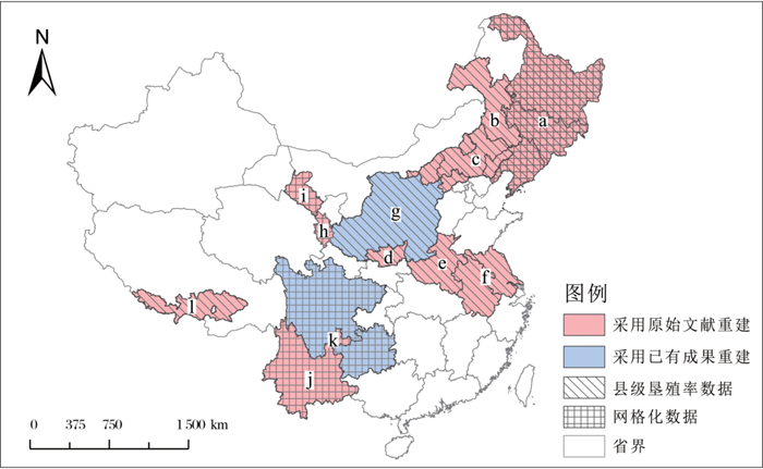
, Ye Yu, Cui YujuanFig.2 Regions of historical land cover reconstructionserving global change research in China a. CNEC dataset,forest cover dataset in Northeast China during past 300a and cropland over Heilongjiang in the late 19th century from references[32,33, 51~53];b.Cultivation ratio in the eastern farming-pastoral ecotone in northern China during the twentieth century, from reference[55];c. Land cover data on county level in Re-Cha-Sui area during past 300a, from reference[54]; d. Cultivation ratio of Guanzhong region in the Qing Dynasty, from reference[58];e.Cropland data on county levelin He’nan Province from 1368 to 1953, from reference[59]; f. Cropland data on county level in the region of Su-Wan from 1500 to 1937, from reference[60];g. Cultivation ratioin Loess Plateau over past 300 years, from reference[57]; h. Cropland spatial patterns for 1726 on Yellow River-Huangshui River vally in northeast Qinghai Tibet Plateau, from reference[64]; i. Historical cultivated land distribution in middle reached of Heihe River Basin, from references[65, 67];j. Gridding cropland data of Yunnan Province in the Qing Dynasty, from reference[63];k. Gridding cropland and forest data in Southwest in the Qing Dynasty, from references[61,62]; l. Cropland data on county level in Central Tibet from 1830 to 1990, from reference[66]