华文剑, 陈海山, 李兴. 中国土地利用/覆盖变化及其气候效应的研究综述. 地球科学进展, 2014, 29(9): 1025-1036[Hua Wenjian, Chen Haishan, Li Xing. Review of Land Use and Land Cover Change in China and Associated Climatic Effects. Advances in Earth Science, 2014, 29(9): 1025-1036]
This is an open-access article distributed under the terms of the Creative Commons Attribution License, which permits unrestricted use, distribution, and reproduction in any medium, provided the original author and source are credited.
人类活动引起的土地利用/覆盖变化(Land Use and Land Cover Change,LUCC)是重要的外强迫之一,但是LUCC对全球及区域气候影响的研究仍然薄弱,至今无法对LUCC的气候效应问题做出系统的评估。研究针对人类活动比较剧烈的中国区域问题,首先回顾了近几十年来中国LUCC的特征,接着从观测和数值模拟2个方面系统地讨论了过去LUCC的研究成果,主要针对LUCC通过生物地球物理过程影响区域气候的工作,总结和归纳了LUCC对中国区域气候的影响问题,进而探讨了LUCC在未来气候变化中可能扮演的角色、亟待解决的问题,以及国内外在这方面的研究动态和未来发展方向。
关键词:
土地利用/覆盖变化; 生物地球物理过程; 气候效应
中图分类号:P96
文献标志码:A
文章编号:1001-8166(2014)09-1025-12
Review of Land Use and Land Cover Change in China and Associated Climatic Effects
Hua Wenjian1,2,3, Chen Haishan1,2,3, Li Xing3
1. Collaborative Innovation Center on Forecast and Evaluation of Meteorological Disasters/Key Laboratory of Meteorological Disaster, Ministry of Education, Nanjing 210044, China
2. International Joint Laboratory on Climate and Environment Change (ILCEC), Nanjing University of Information Science & Technology (NUIST), Nanjing 210044, China
3. School of Atmospheric Sciences, NUIST, Nanjing 210044, China;
Fund:
Abstract
Land Use and Land Cover Change (LUCC) due to human activities is one of important anthropogenic forcings. However, the effects of LUCC on global and regional climate have not been addressed in depth yet. In particular, a systematic evaluation of the climatic effects associated with LUCC is lacking. In this paper, we reviewed the observational and simulation findings of LUCC-related issues, focusing on the characteristic of LUCC in China in recent decades and the impacts of biogeophysical processes on regional climate. The roles of LUCC in future projections and the issues which should be further studied were also discussed. In addition, the latest research tendency and future focuses at home and abroad were also described.
Keyword:
Land Use and Land Cover Change (LUCC); Biogeophysical processes; Climatic effects.
作为人类有目的、有意识的活动,土地利用变化贯穿在人类社会不断发展的整个历史进程中,对全球及区域气候有重要影响[ 4]。随着全球气候与环境变化研究的深入,土地利用/覆盖变化的气候效应受到越来越多的关注,这种变化被认为是近百年来引起全球和区域气候环境变化的主要原因之一[ 5]。为进一步了解土地覆盖变化对气候变化的驱动作用和影响,国际地圈—生物圈计划(IGBP)和全球环境变化人文计划(IHDP)于1995年联合提出了土地利用/覆盖变化(Land Use and Land Cover Change,LUCC)研究计划[ 5]。计划指出,由人类引起的地表覆盖状况的变化,不仅会对局地和区域气候产生影响;而且还可以通过其与天气气候、生态过程、生物地球物理、化学过程等相互作用,影响全球气候。LUCC不仅可以影响大气与地表之间的能量、动量和物质交换,同时还可以对陆地生态系统多样性产生影响,而陆地生态系统的变化是人类社会的可持续性发展及其对全球变化响应的最直接体现[ 6]。所以,LUCC对气候和陆地生态系统有着十分重要的影响,是全球变化研究领域重要的组成部分。
IPCC. Climate change 2013: The physical science basis[M]∥Stocker T F, Qin D, Plattner G K, et al, eds. Contribution of Working Group I to the Fifth Assessment Report of the Intergovernmental Panel on Climate Change. Cambridge, United Kingdom and New York, NY, USA: Cambridge University Press, 2013. [本文引用:1]
[2]
FoleyJ A, DeFriesR, AsnerG P, et al. Global consequences of land use[J]. Science, 2005, 309: 570-574. [本文引用:1]
[3]
National Research Council. Radiative Forcing of Climate Change: Expand ing the Concept and Addressing Uncertainties[M]. Washington DC: National Academies Press, 2005. [本文引用:1]
[4]
Pielke Sr R A. Land use and climate change[J]. Science, 2005, 310: 1 625-1 626. [本文引用:1]
[5]
TurnerB L, MossR H, SkoleD L. Relating land use and global land -cover change: A proposal for an IGBP-HDP core project[R]∥Report from the IGBP-HDP Working Group on Land -Use/Land -Cover Change. Joint Publication of the International Geosphere-Biosphere Programme (Report No. 24) and the Human Dimensions of Global Environmental Change Programme (Report No. 5). Stockholm: Royal Swedish Academy of Sciences, 1993. [本文引用:2]
BartholoméE, BelwardA. GLC2000: A new approach to global land cover mapping from Earth observation data[J]. International Journal of Remote Sensing, 2005, 26(9): 1 959-1 977. [本文引用:1]
[9]
Loveland T, ReedB, BrownJ, et al. Development of a global land cover characteristics database and IGBP DISCover from 1 km AVHRR data[J]. International Journal of Remote Sensing, 2000, 21(6/7): 1 303-1 330. [本文引用:1]
[10]
FriedlM A, McIverD K, HodgesJ C, et al. Global land cover mapping from MODIS: Algorithms and early results[J]. Remote Sensing of Environment, 2002, 83(1): 287-302. [本文引用:1][JCR: 5.103]
[11]
HansenM, ReedB. A comparison of the IGBP DISCover and University of Maryland 1 km global land cover products[J]. International Journal of Remote Sensing, 2000, 21: 1 365-1 373. [本文引用:1]
[12]
RanYouhua, LiXin, LuLing. Accuracy evaluation of the four remote sensing based land cover products over China[J]. Advances in Earth Science, 2009, 24(2): 192-203. 冉有华, 李新, 卢玲. 基于多源数据融合方法的中国1km土地覆盖分类制图[J]. 地球科学进展, 2009, 24(2): 192-203. [本文引用:1][CJCR: 1.388]
[13]
RanYouhua, LiXin, LuLing. Evaluation of four remote sensing based land cover products over China[J]. International Journal of Remote Sensing, 2010, 31: 391-401. [本文引用:1]
[14]
GongPeng. Accuracy test on global land cover map based on the global flux observation station[J]. Progress in Natural Science, 2009, 19(7): 754-759. 宫鹏. 基于全球通量观测站的全球土地覆盖图精度检验[J]. 自然科学进展, 2009, 19(7): 754-759. [本文引用:1][CJCR: 0.854]
[15]
RanYouhua, LiXin, LuLing. Accuracy evaluation of the four remote sensing based land cover products over China[J]. Journal of Glaciology and Geocryology, 2009, 31(3): 490-500. 冉有华, 李新, 卢玲. 四种常用的全球1km土地覆盖数据中国区域的精度评价[J]. 冰川冻土, 2009, 31(3): 490-500. [本文引用:2][CJCR: 1.301]
YangYongke, XiaoPengfeng, FengXuezhi, et al. Comparison and assessment of large-scale land cover datasets in China and adjacent regions[J]. Journal of Remote Sensing, 2014, 18(2): 453-475. 杨永可, 肖鹏峰, 冯学智, 等. 大尺度土地覆盖数据集在中国及周边区域的精度评价[J]. 遥感学报, 2014, 18(2): 453-475. [本文引用:1][CJCR: 0.992]
PielkeSr R A, PitmanA, NiyogiD, et al. Land use/land cover changes and climate: Modeling analysis and observational evidence[J]. WIREs Climate Change, 2011, 2: 828-850. [本文引用:1][JCR: 3.462]
[20]
GeQuansheng, DaiJunhu, HeFanneng, et al. Chinese Land Use Change and Terrestrial Carbon Budget over the Past Three Centuries[M]. Beijing: Science Press, 2008. 葛全胜, 戴君虎, 何凡能, 等. 过去三百年中国土地利用变化与陆地碳收支[M]. 北京: 科学出版社, 2008. [本文引用:3]
[21]
ZouJian, LongHualou. The variation of farm land use and the security pattern of grain production in China since 1978[J]. Journal of Natural Resources, 2009, 24(8): 1 366-1 377. 邹健, 龙花楼. 改革开放以来中国耕地利用与粮食生产安全格局变动研究[J]. 自然资源学报, 2009, 24(8): 1 366-1 377. [本文引用:1][CJCR: 2.407]
[22]
LiuJiyuan, ShaoQuanqin, YanXiaodong, et al. An overview of the progress and research framework on the effects of land use change upon global climate[J]. Advances in Earth Science, 2011, 26(10): 1 015-1 022. 刘纪远, 邵全琴, 延晓冬, 等. 土地利用变化对全球气候影响的研究进展与方法初探[J]. 地球科学进展, 2011, 26(10): 1 015-1 022. [本文引用:1][CJCR: 1.388]
[23]
LiuJiyuan, LiuMingliang, ZhuangDafang, et al. Spatial analysis on recent land use change in China[J]. Science in China (Series D), 2002, 32(12): 1 031-1 040. 刘纪远, 刘明亮, 庄大方, 等. 中国近期土地利用变化的空间格局分析[J]. 中国科学: D辑, 2002, 32(12): 1 031-1 040. [本文引用:1]
[24]
GeQuansheng, ZhaoMingcha, ZhenJingyun. Land use change of China during the 20th century[J]. Acta Geographica Sinica, 2000, 55(6): 698-706. 葛全胜, 赵名茶, 郑景云. 20世纪中国土地利用变化研究[J]. 地理学报, 2000, 55(6): 698-706. [本文引用:1][CJCR: 2.937]
[25]
GeQuansheng, DaiJunhu. Forestry land use change of China in the prometaphase 21st Century[J]. Science in China (Series D), 2005, 35(1): 54-63. 葛全胜, 戴君虎. 20 世纪前、中期中国农林土地利用变化及驱动因素分析[J]. 中国科学: D辑, 2005, 35(1): 54-63. [本文引用:1]
[26]
LiuJiyuan, ZhangZengxiang, ZhuangDafang, et al. A study on the spatial-temporal dynamic changes of land -use and driving forces analyses of China in the 1990s[J]. Geographical Research, 2003, 22(1): 1-12. 刘纪远, 张增祥, 庄大方, 等. 20 世纪90年代中国土地利用变化时空特征及其成因分析[J]. 地理研究, 2003, 22(1): 1-12. [本文引用:1]
[27]
PiaoShilong, FangJingyun. Dynamic vegetation cover change over the last 18 years in China[J]. Quaternary Sciences, 2001, 21(4): 294-302. 朴世龙, 方精云. 最近18年来中国植被覆盖的动态变化[J]. 第四纪研究, 2001, 21(4): 294-302. [本文引用:1][CJCR: 1.911]
[28]
FangJingyun, PiaoShilong, HeJinshi, et al. Enhanced vegetation activity in China for recent two decades[J]. Science in China (Series C), 2003, 33(6): 554-565. 方精云, 朴世龙, 贺金世, 等. 2003. 近20年来中国植被活动在增强[J]. 中国科学: C辑, 33(6): 554-565. [本文引用:1][CJCR: 0.833]
[29]
LiuJiyuan, ZhangZengxiang, XuXinliang, et al. Spatial patterns and driving forces of land use change in China in the early 21st Century[J]. Acta Geographica Sinica, 2009, 64(12): 1 411-1 420. 刘纪远, 张增祥, 徐新良, 等. 21世纪初中国土地利用变化的空间格局与驱动力分析[J]. 地理学报, 2009, 64(12): 1 411-1 420. [本文引用:1][CJCR: 2.937]
[30]
LiQiaoping, DingYihui. Research progress in the effects of vegitation change on regional climate[J]. Journal of Nanjing Institute of Meteorology, 2004, 27(1): 131-140. 李巧萍, 丁一汇. 植被覆盖变化对区域气候影响的研究进展[J]. 南京气象学院学报, 2004, 27(1): 131-140. [本文引用:1][CJCR: 1.005]
ShaoPu, ZengXiaodong. Progress in the study of the effects of land use and land cover change on the climate system[J]. Climatic and Environmental Research, 2012, 17(1): 103-111. 邵璞, 曾晓东. 土地利用和土地覆盖变化对气候系统影响的研究进展[J]. 气候与环境研究, 2012, 17(1): 103-111. [本文引用:1][CJCR: 1.166]
HoughtonR A, HacklerJ L. Sources and sinks of carbon from land -use change in China[J]. Global Biogeochemical Cycles, 2003, 17(2), doi: DOI:10.1029/2002GB001970. [本文引用:1][JCR: 4.682]
[35]
FangJ, ChenA, PengC, et al. Changes in forest biomass carbon storage in China between 1949 and 1998[J]. Science, 2001, 292: 2 320-2 322. [本文引用:1]
GaoZhiqiang, LiuJiyuan. The LUCC responses to climate changes in China from 1980 to 2000[J]. Acta Geographica Sinica, 2006, 61(8): 865-872. 高志强, 刘纪远. 1980—2000年中国LUCC对气候变化的响应[J]. 地理学报, 2006, 61(8): 865-872. [本文引用:1][CJCR: 2.937]
[38]
LinXuechun, YuShuqiu. Interdecadal changes of temperature in the Beijing region and its heat island effect[J]. Chinese Journal of Geophysics, 2005, 48(1): 39-45. 林学椿, 于淑秋. 北京地区气温的年代际变化和热岛效应[J]. 地球物理学报, 2005, 48(1): 39-45. [本文引用:1]
[39]
XieZhiqing, DuYin, ZengYan, et al. Impact of urbanization on regional temperature changein the Yangtze River delta[J]. Acta Geographica Sinica, 2007, 62(7): 717-727. 谢志清, 杜银, 曾燕, 等. 长江三角洲城市带扩展对区域温度变化的影响[J]. 地理学报, 2007, 62(7): 717-727. [本文引用:1][CJCR: 2.937]
[40]
ZhangAiying, RenGuoyu, ZhouJiangxing, et al. On the urbanization effect on surface air temperature trends over China[J]. Acta Meteorologica Sinica, 2010, 68(6): 957-966. 张爱英, 任国玉, 周江兴, 等. 中国地面气温变化趋势中的城市化影响偏差[J]. 气象学报, 2010, 68(6): 957-966. [本文引用:1][JCR: 0.799][CJCR: 0.363]
[41]
RenG, ChuZ, ChenZ, et al. Implications of temporal change in urban heat island intensity observed at Beijing and Wuhan stations[J]. Geophysical Research Letters, 2007, 34, doi: DOI:10.1029/2006GL027927. [本文引用:1][JCR: 3.982]
[42]
TangGuoli, RenGuoyu, ZhouJiangxing. Change of urban heat island intensity and its effect on surface mean air temperature records in Southwest China[J]. Journal of Applied Meteorological Science, 2008, 17: 722-730. 唐国利, 任国玉, 周江兴. 西南地区城市热岛强度变化对地面气温序列影响[J]. 应用气象学报, 2008, 17: 722-730. [本文引用:1][CJCR: 1.379]
[43]
WangFang, GeQuansheng. Estimation on 1980-2009 urban heat island effect in China based on satellite observation of urban land use change[J]. Chinese Science Bulletin, 2012, 57: 951-958. 王芳, 葛全胜. 根据卫星观测的城市用地变化估算中国1980—2009年城市热岛效应[J]. 科学通报, 2012, 57: 951-958. [本文引用:1][CJCR: 0.95]
[44]
ChuZiying, RenGuoyu. Change in urban heat island magnitude and its effect on mean air temperature record in Beijing region[J]. Acta Meteorologica Sinica, 2005, 63(4): 534-540. 初子莹, 任国玉. 北京地区城市热岛强度变化对区域温度序列的影响[J]. 气象学报, 2005, 63(4): 534-540. [本文引用:1][JCR: 0.799][CJCR: 0.363]
[45]
LiQ, ZhangH, LiuX, et al. Urban heat island effect on annual mean temperature during the last 50 years in China[J]. Theoretical and Applied Climatology, 2004, 79: 165-174. [本文引用:1]
[46]
WuKai, YangXiuqun. Urbanization and ground heterogeneous warming in Eastern China[J]. Chinese Science Bulletin, 2013, 58: 642-652. 吴凯, 杨修群. 中国东部城市化与地面非均匀增暖[J]. 科学通报, 2013, 58: 642-652. [本文引用:1][CJCR: 0.95]
[47]
WangJun, YanZhongwei, LiZhen, et al. The influence of urbanization on extreme temperaturein Beijing in recent 30 years[J]. Chinese Science Bulletin, 2013, 58: 3 464-3 470. 王君, 严中伟, 李珍, 等. 近30年城市化对北京极端温度的影响[J]. 科学通报, 2013, 58: 3 464-3 470. [本文引用:1][CJCR: 0.95]
[48]
KalnayE, CaiM. Impact of urbanization and land -use change on climate[J]. Nature, 2003, 423: 528-531. [本文引用:1][JCR: 38.597]
[49]
RenG, ZhouY, ChuZ, et al. Urbanization effects on observed surface air temperature trends in North China[J]. Journal of Climate, 2008, 21: 1 333-1 348. [本文引用:1][JCR: 4.362]
[50]
YangX, HouY, ChenB. Observed surface warming induced by urbanization in east China[J]. Journal of Geophysical Research, 2011, 116, doi: DOI:10.1029/2010JD015452. [本文引用:1]
[51]
LiY, ZhuL, ZhaoX, et al. Urbanization impact on temperature change in China with emphasis on land cover change and human activity[J]. Journal of Climate, 2013, 26: 8 765-8 780. [本文引用:1][JCR: 4.362]
ZhangJ, DongW, WuL, et al. Impact of land use changes on surface warming in China[J]. Advances in Atmospheric Sciences, 2005, 22(3): 343-348. [本文引用:1][JCR: 1.338][CJCR: 0.9244]
[54]
YangXuchao, ZhangYili, LiuLinshan, et al. Sensitivity of surface air temperature change to land types in China[J]. Science in China (Series D), 2009, 39(5): 638-646. 杨续超, 张镱锂, 刘林山, 等. 中国地表气温变化对土地利用/覆被类型的敏感性[J]. 中国科学: D辑, 2009, 39(5): 638-646. [本文引用:1]
[55]
GongTianyu, ShaoQuanqin, LiuJiyuan, et al. The impact of land use/cover types on climate warming in southern China[J]. Geographical Research, 2012, 31(8): 1 465-1 478. 龚天宇, 邵全琴, 刘纪远, 等. 中国南方不同土地利用/覆盖类型对气温升温的影响[J]. 地理研究, 2012, 31(8): 1 465-1 478. [本文引用:2]
[56]
CaoWei, ShaoQuanqin, LiuJiyuan, et al. Impact of land use/land cover and its change on climate warming in Beijing area[J]. Climatic and Environmental Research, 2013, 18(4): 451-460. 曹巍, 邵全琴, 刘纪远, 等. 北京地区土地利用/覆被及其变化对气温升温的影响分析[J]. 气候与环境研究, 2013, 18(4): 451-460. [本文引用:1][CJCR: 1.166]
[57]
ZhangJingyong, DongWenjie, YeDuzheng, et al. New evidence on the impact of China vegetation cover on summer climate[J]. Chinese Science Bulletin, 2003, 48(1): 91-95. 张井勇, 董文杰, 叶笃正, 等. 中国植被覆盖对夏季气候影响的新证据[J]. 科学通报, 2003, 48(1): 91-95. [本文引用:1][CJCR: 0.95]
[58]
WuL, ZhangJ, DongW. Vegetation effects on mean daily maximum and minimum surface air temperatures over China[J]. Chinese Science Bulletin, 2011, 56, doi: DOI:10.1007/s11434-011-4349-7. [本文引用:1][CJCR: 0.95]
[59]
YangXuchao, ZhangYili, DingMingjun, et al. Observational evidence of the impact of vegetation cover on surface air temperature change in China[J]. Chinese Journal of Geophysics, 2010, 53(4): 833-841. 杨续超, 张镱锂, 丁明军, 等. 植被覆盖状况影响中国地表气温变化的观测事实[J]. 地球物理学报, 2010, 53(4): 833-841. [本文引用:1]
[60]
KaufmannR K, SetoK C, SchneiderA, et al. Climate response to rapid urban growth: Evidence of a humaninduced precipitation deficit[J]. Journal of Climate, 2007, 20: 2 299-2 306. [本文引用:1][JCR: 4.362]
[61]
ZhangC, ChenF, MiaoS, et al. Impacts of urban expansion and future green planting on summer precipitation in the Beijing metropolitan area[J]. Journal of Geophysical Research, 2009, 114: D02116, doi: DOI:10.1029/2008JD010328. [本文引用:1]
ZhengYiqun, QianYongfu, MiaoManqian, et al. The effects of vegetation change on regional climate Ⅰ: Simulation results[J]. Acta Meteorologica Sinica, 2002, 60(1): 1-16. 郑益群, 钱永甫, 苗曼倩, 等. 植被变化对中国区域气候的影响I: 初步模拟结果[J]. 气象学报, 2002, 60(1): 1-16. [本文引用:1][JCR: 0.799][CJCR: 0.363]
[70]
MaDi, LiuZhengyu, LüShihua, et al. Short-term climatic impacts of afforestation in the East Asian monsoon region[J]. Chinese Science Bulletin, 2013, 58: 1 661-1 669. 马迪, 刘征宇, 吕世华, 等. 东亚季风区植被变化对局地气候的短期影响[J]. 科学通报, 2013, 58: 1 661-1 669. [本文引用:1][CJCR: 0.95]
[71]
WangLanning, ZhengQinglin, SongQingli. Numerical simulation of the influences of West Central Qinghai Xizang Plateau on East Asia seasonal transition[J]. Plateau Meteorology, 2003, 22(2): 179-184. 王兰宁, 郑庆林, 宋青丽. 青藏高原中西部下垫面对东亚大气环流季节转换影响的数值模拟[J]. 高原气象, 2003, 22(2): 179-184. [本文引用:1][CJCR: 1.688]
[72]
FanGuangzhou, LüShihua, LuoSiwei. The influence of the NW China afforestation on regional climate in East and South Asia[J]. Plateau Meteorology, 1998, 17(3): 300-309. 范广洲, 吕世华, 罗四维. 西北地区绿化对该区及东亚、南亚区域气候影响的数值模拟[J]. 高原气象, 1998, 17(3): 300-309. [本文引用:1][CJCR: 1.688]
[73]
LüShihua, ChenYuchun. The influence of Northwest China afforestation on regional climate in China[J]. Plateau Meteorology, 1999, 18(3): 416-424. 吕世华, 陈玉春. 西北植被覆盖对我国区域气候变化影响的数值模拟[J]. 高原气象, 1999, 18(3): 416-424. [本文引用:1][CJCR: 1.688]
[74]
DingYihui, LiQiaoping, DongWenjie. A numerical simulation study of the impacts of vegetation changes on regional climate in China[J]. Acta Meteorologica Sinica, 63(5): 613-621. 丁一汇, 李巧萍, 董文杰. 植被变化对中国区域气候影响的数值模拟研究[J]. 气象学报, 2005, 63(5): 613-621. [本文引用:1][JCR: 0.799][CJCR: 0.363]
[75]
FanGuangzhou, LüShihua. Numerical simulation study for the effect of ground vegetation type on North China summer precipitation[J]. Plateau Meteorology, 1999, 18(4): 649-658. 范广洲, 吕世华. 陆面植被类型对华北地区夏季降水影响的数值模拟研究[J]. 高原气象, 1999, 18(4): 649-658. [本文引用:1][CJCR: 1.688]
[76]
ZhangYaocun, FuXiaofeng. Possible effect of land use and land cover change on regional climate in south of Jiangsu Province[J]. Advances in Earth Science, 1998, 13(4): 409-411. 张耀存, 傅小锋. 苏南地区土地利用状况变化对区域气候环境的可能影响[J]. 地球科学进展, 1998, 13(4): 409-411. [本文引用:1][CJCR: 1.388]
[77]
ZhangJingyong, DongWenjie, FuCongbin. Impact on regional climate in northern China and southern Mongolia[J]. Chinese Science Bulletin, 2005, 50(1): 53-58. 张井勇, 董文杰, 符淙斌. 中国北方和蒙古南部植被退化对区域气候的影响[J]. 科学通报, 2005, 50(1): 53-58. [本文引用:1][CJCR: 0.95]
[78]
YeZhuojia, LiKerang, HuangMei. Numerical experiments on the impact of land cover on climate[J]. Acta Geographica Sinica, 2000, 55(Suppl. ): 71-81. 叶卓佳, 李克让, 黄玫. 土地覆盖对气候影响的数值敏试验[J]. 地理学报, 2000, 55(增刊): 71-81. [本文引用:1][CJCR: 2.937]
[79]
LiXin, YangXiuqun, TangJianping, et al. Multiple urban heat island s and surface energy balance during summer in Yangtze River Delta city cluster region simulated with WRF/NCAR[J]. Journal of the Meteorological Sciences, 2011, 31(4): 441-450. 李欣, 杨修群, 汤剑平, 等. WRF/NCAR模拟的夏季长三角城市群区域多城市热岛和地表能量平衡[J]. 气象科学, 2011, 31(4): 441-450. [本文引用:1]
[80]
ChenHaishan, ZhangYe. Sensitivity experiments of impacts of large-scale urbanization in East China on East Asian winter monsoon[J]. Chinese Science Bulletin, 2013, 58(13): 1 221-1 227. 陈海山, 张叶. 大规模城市化影响东亚冬季风的敏感性试验[J]. 科学通报, 2013, 58(13): 1 221-1 227. [本文引用:1][CJCR: 0.95]
[81]
ShaoHaiyan, SongJie, MaHongyun. Modeling effect of large-scale urban land use on summer precipitation in East China—The 1994 and 1998 case[J]. Journal of Tropical Meteorology, 2013, 29(2): 299-305. 邵海燕, 宋洁, 马红云. 东亚城市群发展对中国东部夏季风降水影响的模拟——以1994年和1998年为例[J]. 热带气象学报, 2013, 29(2): 299-305. [本文引用:1][CJCR: 1.371]
[82]
FuCongbin, YuanHuiling. Impact of restore natural vegetation on climate and environment in East Asia[J]. Chinese Science Bulletin, 2001, 46(8): 691-695. 符淙斌, 袁慧玲. 恢复自然植被对东亚夏季气候和环境影响的一个虚拟试验[J]. 科学通报, 2001, 46(8): 691-695. [本文引用:1][CJCR: 0.95]
[83]
FuC. Potential impacts of human-induced land cover change on East Asia monsoon[J]. Global and Planetary Change, 2003, 37(3): 219-229. [本文引用:1][JCR: 3.155]
[84]
GaoX, LuoY, LinW, et al. Simulation of effects of land use change on climate in China by a regional climate model[J]. Advances in Atmospheric Sciences, 2003, 20(4): 583-592. [本文引用:1][JCR: 1.338][CJCR: 0.9244]
[85]
GaoXuejie, ZhangDongfeng, ChenZhongxin, et al. Numerical simulation on impact of land use change on regional climate in China[J]. Science in China(Series D), 2007, 37(3): 397-404. 高学杰, 张冬峰, 陈仲新, 等. 中国当代土地利用对区域气候影响的数值模拟[J]. 中国科学: D辑, 2007, 37(3): 397-404. [本文引用:1]
[86]
DongSiyan, YanXiaodong, XiongZhe. Varying responses in mean surface air temperature from land use/cover change in different seasons over northern China[J]. Acta Ecologica Sinica, 2013, 33(3): 167-171. [本文引用:1]
[87]
HuaWenjian, ChenHaishan. Impacts of regional-scale land use/ land cover change on diurnal temperature range[J]. Advances in Climate Change, 2013, 9(2): 117-122. 华文剑, 陈海山. 大尺度土地利用/土地覆盖变化对气温日较差的影响[J]. 气候变化研究进展, 2013, 9(2): 117-122. [本文引用:1]
[88]
ChenJunming, ZhaoPing, GuoXiaoyin. Numerical simulation of the impacts of changes in the vegetation in the western China on the summer climate over the northern China[J]. Acta Meteorologica Sinica, 2010, 68(2): 173-181. 陈军明, 赵平, 郭晓寅. 中国西部植被覆盖变化对北方夏季气候影响的数值模拟[J]. 气象学报, 2010, 68(2): 173-181. [本文引用:1][JCR: 0.799][CJCR: 0.363]
[89]
DongSiyan, YanXiaodong, XiongZhe. Modeled impacts of land use/cover change at northeast on climate[J]. Climatic and Environmental Research, 2014, 19(3): 351-361. 董思言, 延晓冬, 熊喆. 东北农田扩张对气候影响的数值模拟[J]. 气候与环境研究, 2014, 19(3): 351-361. [本文引用:1][CJCR: 1.166]
[90]
ChenHaishan, LiXing, HuaWenjian. Numerical simulation on impact of land use/land cover change over China on regional climate during the last 20 years[J]. Chinese Journal of Atmospheric Sciences, 2014, doi: DOI: 103878/j. issn. 1006-9895. 1404. 14114. 陈海山, 李兴, 华文剑. 近20年中国土地利用变化影响区域气候的数值模拟[J]. 大气科学, 2014, doi: DOI:10.3878/j.issn.1006-9895.1404.14114. [本文引用:1][CJCR: 1.948]
[91]
ChenXing, LeiMing, TangJianping. Simulating the effect of changes vegetation on the climate change in Eurasia[J]. Advances in Earth Science, 2006, 21(10): 1 075-1 082. 陈星, 雷鸣, 汤剑平. 地表植被改变对气候变化影响的模拟研究[J]. 地球科学进展, 2006, 21(10): 1 075-1 082. [本文引用:1][CJCR: 1.388]
[92]
LiQiaoping, DingYihui, DongWenjie. A numerical simulation on impact of historical land -use changes on regional climate in China since 1700[J]. Acta Meteorologica Sinica, 2006, 64(3): 257-270. 李巧萍, 丁一汇, 董文杰. 中国近代土地利用变化对区域气候影响的数值模拟[J]. 气象学报, 2006, 64(3): 257-270. [本文引用:1][JCR: 0.799][CJCR: 0.363]
[93]
YinYongfei, ChenXing, ZhangJie, et al. Land use change of the past 300 years in China and its climate effects[J]. Quaternary Sciences, 2009, 29(6): 1 162-1 169. 尹永飞, 陈星, 张洁, 等. 中国过去300年土地利用变化及其气候效应[J]. 第四纪研究, 2009, 29(6): 1 162-1 169. [本文引用:1][CJCR: 1.911]
[94]
ChenFeng, XieZhenghui. A land cover dataset based on Chinese vegetation data and its impact on land surface simulations[J]. Chinese Journal of Atmospheric Sciences, 2009, 33(4): 681-697. 陈锋, 谢正辉. 基于中国植被数据的陆面覆盖及其对陆面过程模拟的影响[J]. 大气科学, 2009, 33(4): 681-697. [本文引用:1][CJCR: 1.948]
ZhengYiqun, YuGe, WangSumin, et al. Simulation of vegetation and climate changes in atmospheric CO2 concentration influence of East Asia in recent 140 years[J]. Progress in Natural Science, 2003, 13(9): 951-956. 郑益群, 于革, 王苏民, 等. 140年来植被和大气CO2浓度变化对东亚气候影响的数值模拟[J]. 自然科学进展, 2003, 13(9): 951-956. [本文引用:1][CJCR: 0.854]
[97]
ZhaoM, PitmanA J. The relative impact of regional scale land cover change and increasing CO2 over China[J]. Advances in Atmospheric Sciences, 2005, 22(1): 58-68. [本文引用:1][JCR: 1.338][CJCR: 0.9244]
[98]
FindellK L, PitmanA J, England M H, et al. Regional and global impacts of land cover change and sea surface temperature anomalies[J]. Journal of Climate, 2009, 22: 3 248-3 269. [本文引用:1][JCR: 4.362]
[99]
VoldoireA. Quantifying the impact of future land -use changes against increases in GHG concentrations[J]. Geophysical Research Letters, 2006, 33: L04701, doi: DOI:10.1029/2005GL024354. [本文引用:1][JCR: 3.982]
[100]
PitmanA J, AvilaF B, AbramowitzG, et al. Importance of background climate in determining impact of land -cover change on regional climate[J]. Nature Climate Change, 2011, doi: DOI:10.1038/NCLIMATE1294. [本文引用:1][JCR: 14.472]
[101]
HuaWenjian, ChenHaishan. Recognition of climatic effects of land use/land cover change under global warming[J]. Chinese Science Bulletin, 2013, 58: 3 852-3 858. 华文剑, 陈海山. 全球变暖背景下土地利用/土地覆盖变化气候效应的新认识[J]. 科学通报, 2013, 58: 2 832-2 839. [本文引用:1][CJCR: 0.95]
[102]
HeChunyang, ShiPeijun, LiJinggang, et al. Scenarios simulation land use change in the Northern China[J]. Acta Geographica Sinica, 2004, 59(4): 599-607. 何春阳, 史培军, 李景刚, 等. 中国北方未来土地利用变化情景模拟[J]. 地理学报, 2004, 59(4): 599-607. [本文引用:1][CJCR: 2.937]
[103]
LiYuechen, HeChunyang. Simulation and projection of land use/cover change over north China[J]. Chinese Science Bulletin, 2008, 53(6): 713-723. 李月臣, 何春阳. 中国北方土地利用/覆盖变化的情景模拟与预测[J]. 科学通报, 2008, 53(6): 713-723. [本文引用:1][CJCR: 0.95]
[104]
SongShuai, JuYongmao, WangHanjie. Possible impacts of land use change on regional rainfallassociated with orderly human activities[J]. Climatic and Environmental Research, 2008, 13(6): 759-774. 宋帅, 鞠永茂, 王汉杰. 有序人类活动造成的土地利用变化对区域降水的可能影响[J]. 气候与环境研究, 2008, 13(6): 759-774. [本文引用:1][CJCR: 1.166]
[105]
LiJianyun, WangHanjie. Regional climate effects of large-scale agricultural irrigation related to South-to-North Water Transfer Project in China[J]. Advances in Water Science, 2009, 20(3): 343-349. 李建云, 王汉杰. 南水北调大面积农业灌溉的区域气候效应研究[J]. 水科学进展, 2009, 20(3): 343-349. [本文引用:1][CJCR: 1.23]
PitmanA J, deNoblet-Ducoudré N, CruzF T, et al. Uncertainties in climate responses to past land cover change: First results from the LUCID intercomparison study[J]. Geophysical Research Letters, 2009, 36: L14814, doi: DOI:10.1029/2009GL039076. [本文引用:2][JCR: 3.982]
[108]
BrovkinV, BoysenL, AroraV K, et al. Effect of anthropogenic land -use and land cover changes on climate and land carbon storage in CMIP5 projections for the 21st century[J]. Journal of Climate, 2013, 26: 6 859-6 881. [本文引用:1][JCR: 4.362]
[109]
BrovkinV, SitchS, WernerV B, et al. Role of land cover changes for atmospheric CO2 increase and climate change during the last 150 years[J]. Global Change Biology, 2004, 10: 1 253-1 266. [本文引用:2][JCR: 6.91]
[110]
deNoblet-Ducoudré N, BoisierJ, PitmanA, et al. Determining robust impacts of land use induced land -cover changes on surface climate over North America and Eurasia: Results from the first set of LUCID experiments[J]. Journal of Climate, 2012, 25: 3 261-3 281. [本文引用:1][JCR: 4.362]
[111]
MahmoodR, PielkeSr R A, HubbardK G, et al. Impacts of land use/land cover change on climate and future research priorities[J]. Bulletin of the American Meteorological Society, 2010, 91: 37-46. [本文引用:1][JCR: 6.591]
[112]
SokolovA P, KicklighterD W, MelilloJ M, et al. Consequences of considering carbon-nitrogen interactions on the feedbacks between climate and the terrestrial carbon cycle[J]. Journal of Climate, 2008, 21: 3 776-3 796. [本文引用:1][JCR: 4.362]
[113]
MatthewsH D, WeaverA J, MeissnerK J, et al. Natural and anthropogenic climate change: Incorporating historical land cover change, vegetation dynamics and the global carbon cycle[J]. Climate Dynamics, 2004, 22: 461-479. [本文引用:1][JCR: 4.231]
[114]
LawrenceP J, FeddemaJ J, BonanG B, et al. Simulating the biogeochemical and biogeophysical impacts of transient land cover change and wood harvest in the Community Climate System Model (CCSM4) from 1850 to 2100[J]. Journal of Climate, 2012, 25: 3 071-3 095. [本文引用:1][JCR: 4.362]
[115]
BettsR A. Offset of the potential carbon sink from boreal forestation by decreases in surface albedo[J]. Nature, 2000, 408: 187-190. [本文引用:1][JCR: 38.597]
[116]
AroraV K, MontenegroA. Small temperature benefits provided by realistic afforestation efforts[J]. Nature Geoscience, 2011, 4(8): 514-518. [本文引用:1][JCR: 12.367]
①Department of Geography,University of Maryland,Maryland,US;②Institute of Geography,CAS,Beijing 100101,China
Terrestrial ecosystems and climatic systems influence each other through biophysical processes that involve the transfers of energy and water at the land surface and biogeochemical cycles that affect the concentrations of greenhouse gases and aerosols in the atmosphere. Studies of ecosystem-climate interactions have evolved from uses of land surface parameterizations (LSPs) to sensitivity analysis of climatic responses to equilibrium ecosystem changes and to dynamic, interactive coupling of ecosystem and climatic processes. System modeling is the most important means to study ecosystem-climate interactions. The global ecosystem models that have been used in the studies can be classified into biophysical, biogeography, and biogeochemical types.Ecosystem changes as a whole in the past have accelerated warming by increasing the emissions of CO2, CH4, and N2O and reducing the regulation of vegetation to water cycling.Ecosystem negative feed-backs on climate have emerged with increases in CO2sequestration and the stabilization of CH4emissions,but continued increases in anthropogenic N2fixation may greatly enhance N2O emissions. To quantify accurately the feedback effects requires investigations of the dynamic ecosystem-climate interactions at seasonal and interannual scales. Future studies should focus on both developing integrated dynamic ecosystem models (IDEM) that can describing both functional and structural changes and coupling biophysical and biogeochemical processes and observing large-scale, long-term ecosystem changes. The observations are essential for deepening understanding of ecosystem-climate interactions and validate global ecosystem models.
1.Cold and Arid Regions Environmental and Engineering Research Institute, Chinese Academy of Sciences, Lanzhou730000, China; 2. College of Earth and Environmental Sciences, Lanzhou University, Lanzhou730000, China
Historical land use and cover change have been one of the hot topics of international concerns. Reconstruction and research of historical land use and cover change can understand the process of past changes in landscape environments of land surface, and have an important guiding role in the current land use patterns and in predicting the future land use and cover change. Based on the main data sources used and data process metheds and study ideas, the research status of historical land use change are reviewed both at home and abroad in terms of historical documents, historical maps, inspection and investigation reports, model simulation and integrated multisource data and multidisciplinary approaches. Then, the advantages and disadvantages and uncertainties of the various methods used to carry out the research of historical land use change are discussed and analyzed according to the characteristics of different data sources and methods: ①We have wide range of historical documents and huge quantity of information, but there are a lot of noise and omissions, and lack of visual spatial information; ②Historical maps can provide a relatively intuitive spatial location information, but the mapping technology was poor and the land use categories were coarse in historical period; ③Past inspection and investigation records with a smaller spatial and temporal scales are fairly standard, but they are difficult to meet the needs of the earlier period; ④Using the models to implement the simulation in different spatial and temporal scales is relatively easy, but more input data are needed. Finally, the integrated multisource data and multidisciplinary approach are considered as the only way to understand the process of historical land use change essentially and completely, and it will be the main ideas to study the historical land use change in the future.
Cold and Arid Regions Environmental and Engineering Research Institute, Chinese Academy of Sciences, Lanzhou 730000, China
Land cover plays a significant role in the earth system science, which reflects the influence of human activities and environmental changes. In China, many land use/cover maps can be used in recent years. How to combine these date effectively to better produce land cover map is a key question. This paper presents a method to map land cover classification using Dempster-Shafer evidential reasoning (DS). DS theory is a non-parametric classifier and can handle data from any number of sources at any scale of measurement and has an explicit mechanism for handling information uncertainty through the use of the concept of ignorance. The 1km land use data of China in 2000 from China landuse database, the 1∶1000000 vegetation map, the 1km glacier map from 1∶100000 glacier map, the 1∶1000000 wetland map and the MODIS land cover classification product (MOD12Q1) as multi-source of evidence to support each IGBP land cover class. These evidences are then combined using Dempster′s Rule of combination. Finally, a new land cover map with higher accuracy is generated by a decision rule based on maximum belief function and could be representative of the Chinese land-cover status in 2000. A simple compare validation is taken and result shows that the accuracy of each land cover class of new land cover map has be strongly promoted relative to IGBP DISCover and MOD12Q1 land cover map especially for the accuracy of the croplands, urban, glacier, wetland and water bodies class. The evidence theory is can be used for fusing multi classification information. The fusion result is sensitive for the basic probability assignment of input data. The results will be validated further and the basic probability for multi-source input data will be assigned more scientific.
Accuracy evaluation is the precondition and foundation for the application of land cover data. In order to study the ability of describing the land cover status in China, GLC2000, MODIS V004 and MODIS V005 land cover data on distribution area and spatial distribution were compared with the reference data in 2000 from RESDC (Data Center for Resources and Environmental Sciences, Chinese Academy of Science) based on land cover types aggregating. Land cover diversity index was introduced in this study to analyze the impact of land cover data accuracy. The results showed that: all the three data can describe the spatial distribution of land cover well in China; the precision of GL2000, MODIS V004 and MODIS V005 were 62.8%, 61.7% and 61.9% respectively; the proportion of forest/woods for the three land cover data were larger than that of reference data, the areas of building, wetlands and water bodies were smaller; the accuracy of forest/woods, grass/shrub lands, croplands and barren/ice were higher than that of urban and wetlands; the precise of forest/woods and croplands of GLC2000 were the most in provincial level, MODIS V005 has the highest user and producer accuracy on average; the precision of the three data were decreased with the increase of land cover diversity index, and it was increased with the increase of the proportion of land cover diversity index that equals to 1, land cover heterogeneity has the least impact on MODIS V005 data.
Large-scale land cover datasets comprise an important foundation of the research on land surface processes, ecosystem assessment, and environmental modeling. The evaluation of existing land cover datasets provides a guide to dataset use and new dataset production. Five kinds of global land cover datasets (IGBP DISCover, UMD, GLC2000, MOD12Q1, and GlobCover 2005) over China and adjacent regions are evaluated in this paper. First, the categories of five land cover datasets are translated into the International Geosphere-Biosphere Programme-IGBP scheme based on the correlation coefficients of the corresponding classes, which is computed according to the class definition in each land cover dataset. Second, the spatial agreements of the five land cover datasets are analyzed using visual comparison and per-pixel comparison. Finally, the classification accuracy of the five land cover datasets is evaluated based on validation samples collected through Google Earth high-resolution satellite images. The results show large areas of disagreement among the five land cover datasets, and the overall consistency among them is low. GLC2000 has the highest overall accuracy and Kappa coefficient, whereas GlobCover 2005 has the lowest overall accuracy and Kappa coefficient.
该研究以中国耕地类别为研究对象,选择2000年中国土地利用数据(NLCD-2000)为参考数据,利用比较分析法,从面积数量精度和空间位置精度两方面对目前4类全球土地覆盖数据(UMD、IGBP-DISCover、MODIS和GLC2000)产品进行了精度验证,并分析研究了4类数据精度的异同性.结果表明,4类全球数据对中国耕地数量特征和空间位置特征的估测具有明显的区域差异性.MODIS数据集和GLC2000数据集对中国耕地制图的总体精度要高于UMD数据集和IGBP-DISCover数据集.4类数据制图精度高的区域主要分布在中国的农业主产区,而误差大的区域主要分布在中国山区或耕地比例低的区域.低空间分辨率的信息源、基于像元的分类方法,以及中国复杂地形特征是4类全球土地覆盖数据精度差异的主要原因. Abstract: This study aims to examine the suitability of four global land cover datasets (UMD, IGBP-DISCover, MODIS and GLC2000) for their accuracies in mapping and monitoring cropland across China. For that, four global land cover products were firstly compared with the national land cover dataset 2000 (NLCD-2000) at provincial, regional and national scales to evaluate the accuracies of estimation of aggregated cropland area in China. This was followed by a spatial comparison to assess their accuracies in estimating the spatial distribution of cropland across China. The results showed that there were varying levels of apparent discrepancies in estimating China's cropland among these four global datasets, and that both aggregated areas and spatial agreement between them varied from region to region. MODIS and GLC2000 datasets had a relatively higher accuracy in depicting China's cropland than UMD and IGBP-DISCover datasets. The coarse spatial resolution and per pixel classification approach, as well as landscape heterogeneity, are the main reasons for large discrepancies between these four global land cover datasets and NLCD-2000 dataset.
1.The Institute of Geographic Sciences and Natural Resources Research, Chinese Academy of Sciences, Beijing100101,China; 2.The Institute of Atmospheric Physics,Chinese Academy of Sciences,Beijing 100029,China; 3. Beijing Normal University, Beijing 100875, China; 4. The National Climate Centre of China Meteorological Administration, Beijing100081, China
In this paper, the primary scientific issues about the impacts of land use and land cover change (LUCC) on global climate are analyzed, and its research progress is reviewed. LUCC-climate-ecosystem research system integrated with satellite and field observation is constructed, with the consideration of the intercross, integration and interpenetration among subjects to study the land use change effects on global climate. Furthermore, dynamic patterns and mechanisns of LUCC, research approaches about the mechanisms and effectiveness of LUCC impacts on ecosystem and climate, and then the technical routes for the application of integrated satellite-earth research system to land use change effects on global climate are discussed and analyzed. The following scientific objectives will be realized based on above research approaches and technical routes. ① to further study the basic regulation, driving forces and its climatic/ecological effects of LUCC in three spatial scales: typical regions, key nations and global; ② to illustrate the mutual-feedback mechanisms among anthropogenic activities, climate change and LUCC processes, and to reveal the impact mechanisms of large scale LUCC processes on climate and terrestrial ecosystem; ③ to construct integrated simulated platform on multiple scale LUCC and its climatic and ecological effectiveness, and to quantitatively simulate the different spatial and temporal scale of LUCC trends and its climatic/ecological effects in different scenarios, then to define the contribution rate of large scale LUCC impacts on climate change in two ways, that is through initiation of the budget change of greenhouse gases and through the change in land surface and atmosphere processes; ④ to propose the strategy to responding to the impacts of LUCC on climate and ecosystem in the future, and to supply scientific basis for nations to respond to global change and to achieve sustainable development.
Institute of Geographic Sciences and Natural Resources Research, CAS, Beijing 100101, China
The research of landuse and land cover change is a core project in the international global environmental change studies, and project aims at revealing how landcover has been changed in China in the last century will be an important and necessary action. Based on the standardized and unified data collected from numrable and valuable historical documents and various statistical reports which were published before 1950 but now are scattered in the nationwide libraries and archives, and the classification data obtained by investigations and remote sensing after 1950, the landcover change and characteristics of land use in China during the 20th century are traced and analyzed in this paper. The results are: ① The unused and non arable land keeps decreasing and landcover has been changed obviously. ② The cultivated land, forestland, horticultural land, settlement, and mining land, and transportation land are increasing, in which, the augmentations from 1914 to 1997 for cultivated land, forest land, horticultural land, settlement and mining land, and transportation land were 49×10 6 hm 2 , 49×10 6 hm 2 , 7 1×10 6 hm 2 , 17 5×10 6 hm 2 , 3 1×10 6 hm 2 , respectively. ③ The grasslands, uncultivated arable land, water bodies and wetland are decreasing, in which, the decrements from 1950 to 1990 for the grasslands and uncultivated arable land were 65×10 6 hm 2 and 90×10 6 hm 2 . ④ The proportional structure of land use consisted in the cultivated, forestland, grassland, horticultural land, settlement and mining land, transportation land, water bodies, and others by 10 19%, 13 02%, 40 83%, 0 11%, 0 49%, 0 21%, 2 35%, 32 8% in 1949, and by 14 14%, 23 65%, 26 91%, 0 85%, 2 33%, 0 53%, 4 30%, 27 29% in 1997, respectively.
Department of Urban &|Environmental Science, and Center for Ecological Research &Education, Peking University, Beijing 100871
Dynamic changes in Chinese terrestrial vegetation over the last 18 years from 1982 to 1999 and their spatial patterns were explored, using NDVI (normalized difference vegetation index) data derived from remote sensing imagery (NOAA/AVHRR), along with the information of vegetation distribution and climatic records. As a result, the dynamic vegetation cover change was closely coupled with climatic fluctuation, and showed a remarkable regional difference. In the past 18 years, regions with significant decline in NDVI appeared in Northwest China and Tibetan Plateau whilest a marked increase occurred in eastern regions of the country. The trends in interannual NDVI change displayed a large discrepancy between 1980's and 1990's; areas with decline in NDVI in 1990's was considerably larger than in 1980's, especially for northwest arid region. Due to rapid urbanization, Zhujiang River delta and Changjiang River delta showed a sharp drop in NDVI during the past 18 years.
1. Institute of Geographic Sciences and Natural Resources Research, CAS, Beijing 100101, China; 2. Institute of Remote Sensing Applications, CAS, Beijing 100101, China; 3. Chengdu Institute of Mountain Hazards and Environment, CAS, Chengdu 610041, China; 4. Northeast Institute of Geography and Agricultural Ecology, CAS, Changchun 130012, China; 5. Wuhan Institute of Geodesy and Geophysics, CAS, Wuhan 430077, China; 6. Cold and Arid Regions Environmental and Engineering Research Institute, CAS, Lanzhou 730000, China; 7. Nanjing Institute of Soil Science, CAS, Nanjing 210008, China; 8. Xinjiang Institute of Ecology and Geography, CAS, Urumqi 830011, China; 9. Nanjing Institute of Geography and Limnology, CAS, Nanjing 210008, China
Land use and land cover change as the core of coupled human-environment systems has become a potential field of land change science (LCS) in the study of global environment change. Based on remotely sensed data of land use change with the spatial resolution of 1km ×1km on national scale among every five years, this paper designed a new dynamic regionalization according to the comprehensive characteristics of land use including regional differentiation, physical, economic, and macro-policy factors as well. Spatial pattern of land use change and its driving forces were investigated in Chia in the early 21st century. To sum up, land use pattern of this period was characterized by rapid changes in the whole country. Over the agricultural zones,e.g., Huang-Huai-Hai Plains, the southeast coastal area and Sichuan Basin, the built-up and residential areas were considerably expanded to a great proportion in the northwestern oasis agricultural zones and the northeastern zone led to a slight increase of arable land aea in the northern China. Due to the "grain for green" policy, forest area was significantly increased in the middle and western developing region,Where the vegetation coverage was substanially enlarged, likewise. This paper argued the main driving forces as the implementation of the strategy on land use and regional development, such as the "Western Development", "the Revitalization of the Northeast" policy, coupled with rapidly economic development during this period.
Worldwide land use changes are being driven by the demand of food, fiber, water, and shelter to more than six billion people. Land use change is becoming an important anthropogenic forcing of global climate system as referred by IPCC AR4(IPCC,2007). The impacts of land use change on climate system can be divided into two major processes,that is biogeophysical and biogeochemical. The authors reviewed relative researches and hot topics on the two processes, respectively, and introduced two methodologies of assessing the relative importance for the two processes, one is to calculate their radiative forcing, the other is to use the couple model to simulate the two processes at the same time. These two methodologies were applied to access the policy of climate change such as afforestation, reforestation, and carbon sequestration. The uncertainties and further research topics were also discussed.
Land Use and Land Cover Change (LUCC or LULCC) has a significant influence on the environment on which mankind’s survival depends, and it is closely related to human being’s social-economical activities. The role of humans within the climate system involves much more than global warming due to greenhouse gases. By changing the natural land surface directly and other biogeophysical or biogeochemical processes indirectly, LUCC represents a first order human climate forcing. This manuscript reviews the history of the study of LUCC and its correlation to climate system briefly. Forcing due to LUCC has significant spatial heterogeneity, leading to spatial variability in the associated climate response. Summarizing recent peer-reviewed papers, the authors conclude that the impact of LUCC such as deforestation, urbanization, damming, etc on regional climate is robust while it does not have strong effects at global level, because the variability of LUCC has regional magnitudes much greater than its global average. The net biogeophysical impact of LUCC results from the competition between the effects of variation of albedo, evapotranspiration efficiency, and surface roughness. LUCC leads to warming in tropical and subtropical regions and cooling in temperate and boreal zones. Current global warming owing to LUCC is predominantly driven by changes in surface hydrology through reduced evapotranspiration and latent heat flux, with the radiative forcing playing a secondary role. Finally existing issues in current study of the influence of LUCC on climate system are pointed out. The authors recommend that three climate metric should be assessed as a start and interdisciplinary cooperation is essential in future research.
Laboratory of Quantitative Vegetation Ecology, Institute of Botany, CAS, Beijing 100093, China
Land Use /Cover Change (LUCC) directly reflects the dominant factor leading to global change—human activities.The study on LUCC will enhance the understanding of the interaction between global change and terrestrial ecosystems,and improve the accuracy of evaluating and predicting the responses of terrestrial ecosystems to global change.In this paper,based on the two well known balance equations—heat and water balance equations on the earth's surface,the authors discuss the feedback of LUCC on climate.The study shows:(a)Vegetation has the function of reducing runoff,storing water and mitigating the effects of global climate change.The effect of vegetation on precipitation may not be considered.(b)The effect of vegetation on climate depends on specific regions.(c)In the middle latitude areas,if changes of the surface albedo and runoff meet the following relationship,Δf=5Δα×10 -4 g/cm 2 ·min vegetation will not have an effect on earths surface temperature.This result indicates that strategies concerning global change should be suitable to local conditions.
Institute of Geographic Sciences and Natural Resources Research, CAS, Beijing 100101, China
Adopted with Holdridge Life Zone Model (HLZM), Weight Centre Model (WCM) and Land Use Degree Model (LUDM), climate data of China in recent 20 years and 2-period LUCC data covering China are used to analyze the impact degree and direction of changes caused by climatic changes and human activities to China vegetation covers and land use. In recent 20 years, the rise in temperature and increase in precipitation in most parts of China have influenced not only China's biome, but also growth conditions of Holdridge life zone deeply. In this period, variations in both precipitation and temperature in Northeast China, North China and the Inner Mongolia Plateau have improved living environment and led to the transformation of Nature Covered Ecological Type from unutilized land to grassland and shrubland types, grassland and shrubland types transformed to forest and arable land. Meanwhile, China's economic development in recent 20 years, as well as land use increment in rural and urban areas for construction and transportation purposes in eastern coastal zones have made Land Use Type developed from farmland to construction land, leading to increase in land use degree index. Thereby the dual impacts by climatic changes and economic development resulted in a shift of Land Use Degree Weight Centre northeastward by 54 km. With regard to Land Use Degree Excursion Intensity, in east-west direction, 81% is caused by climatic changes and 19% by anthropogenic impacts; while in north-south direction, 85% is caused by climatic changes and 15% by anthropogenic impacts.
1National climate Center, CMA, Beijing 100081 2Chinese Academy of Meteorological Sciences, Beijing 100081
We study large scale temperature changes and heat island effect in the Beijing region are investigated in this paper using the annual mean temperature data from 1960 to 2000 at 20 meteorological stations. Main conclusions are the following two points. First, the interannual changes of the temperature in the region show a feature of large-scale temperature change. 1981 is a remarkable jump point, the temperature increases by 0.55℃ after the jump compared with that before the jump and the warming rate in the recent 40-year is 0.25℃/10-year. Second, the urban heat island effect in the Beijing region is typical. The averaged urban heat island intensity over 1960-2000 is about 1℃. Along with the acceleration of urban construction and urbanization, the urban heat island intensity is also increasing, and its growth rate in the recent 40-year is 0.31℃/10-year.
1. Jiangsu Institute of Meteorological Sciences, Nanjing 210008, China; 2. Department of Atmospheric Sciences, Nanjing University, Nanjing 210093, China; 3. Nanjing Institute of Geography and Limnology, CAS, Nanjing 210008, China
Based on non-radiance-calibrated DMSP/OLS nighttime light imagery from 1992 to 2003, urban land area statistical data, meteorological data and land surface temperature data retrieved by MODIS and NOAA/AVHRR data, the influence of urbanization on regional climate trend of temperature in the Yangtze River Delta was analyzed. Conclusions are as follows: (1) There is a significant urbanization process from 1992 to 2003 in the Yangtze River Delta, and the annual mean air temperature increased at a rate of 0.28-0.44 o C/10a in mega city. (2) The urban heat island (UHI) effect on regional mean air temperature in different seasons is summer > autumn > spring > winter. (3) The UHI intensity and the urban total population logarithm are creditable correlated. (4) The UHI effect made the regional annual mean air temperature increased 0.072 o C from 1961 to 2005 and 0.047 o C from 1991 to 2005, and the annual maximum air temperature increased 0.162 o C and 0.083 o C from 1991 to 2005, all indicating that the urban expansion in the Yangtze River Delta from 1991 to 2005 may be regarded as a serious climate signal.
利用DMSP/OLS 夜间灯光数据、土地利用统计数据和气象站常规观测资料, 结合NOAA/AVHRR、MODIS 反演的月地表温度数据, 定量考察了长江三角洲城市群热岛增温效应对区域温度气候趋势的贡献, 结果表明: ① 1992-2003 年长江三角洲城市化经历了一个快速的空间扩展过程, 宁镇扬、苏锡常、上海大城市区、杭州湾4 个城市群构成了一个“之” 字形城市带, 城市群之间出现城市化连片趋势, 城市带区域内1961-2005 年年平均气温增温 速率为0.28~0.44 o C/10a, 显著高于非城市带区域。② 城市热岛效应对区域平均温度的影响以夏秋季最强, 春季次之, 冬季最弱。③ 长江三角洲城市带热岛强度和城市总人口对数呈线性正相关关系。④ 城市带增温效应使得区域的年平均气温在1961-2005 年间增加了0.072 o C, 其中1991-2005 年间增温幅度为0.047 o C; 年最高气温升高了0.162 o C, 其中1991-2005 年间 增温幅度为0.083 o C, 表明1991-2005 年间长江三角洲城市带的空间扩展正在改变区域温度变化趋势, 且这种增温趋势显著。
Using a data set of monthly mean temperature from 20 stations, the effect of urban heat island magnitude evolution on mean surface air temperature records of the last 40 years in Beijing region was analyzed. Two stages, a short cooling period between 1961-1969 and a significant warming period after 1969, were observed for both the urban and rural annual mean temperatures in Beijing area, and an obvious warming trend for each station is detected. The warming rate in winter is much higher than in any other seasons. It was also noted that the temperature anomaly series as calculated using the data from Beijing Station and the national basic/reference stations of the study area are significantly impacted by urban warming, especially for the last 20 years. Although the positive tendency of temperature anomalies is much greater in winter than in any other seasons, the urban warming is generally stronger in warm seasons. By analyzing the difference of rates of temperature changes between basic/reference stations and rural stations, we could further obtain the rate of warming induced by urbanization, and could calculate the relative contribution of urban warming to the total change in mean temperature. The contribution for annual mean temperature change of the basic/reference stations in Beijing area reaches to 48.5% for period of 1979-2000 and 71.1% for period of 1961-2000. It is also obvious that the contribution generally increases from winter and spring to summer and autumn. During 1961-2000, the recorded warming in summer and autumn can be entirely accounted for by the urbanization effect. Above all, these results indicate the essentiality to pay more attention to the effect of urban heat island magnitude change on long-term mean temperature series at least on regional scale.
1.National Meteorological Center, CMA Beijing China 2.Physical Institute, Peking University Beijing China 3.Jiangsu Province Key Laboratory of Meteorological Disaster and Environmental Variation Nanjing China
Based on China s fifth population survey (2000) data and homogenized annual mean surface air temperature data, the urban heat island (UHI) effect on the warming during the last 50 years in China was analyzed in this study. In most cities with population over 10 4 , where there are national reference stations and principal stations, most of the temperature series are inevitably affected by the UHI effect. To detect the UHI effect, the annual mean surface air temperature (SAT) time series were firstly classified into 5 subregions by using Rotated Principal Components Analysis (RPCA) according to its high and low frequency climatic change features. Then the average UHI effect on each subregion s regional annual mean STA was studied. Results indicate that the UHI effect on the annual mean temperatures includes three aspects: increase of the average values, decrease of variances and change of the climatic trends. The effect on the climatic trends is different from region to region. In the Yangtze River Valley and South China, the UHI effect enhances the warming trends by about 0.011 °C/decade. In the other areas, such as Northeast, North-China, and Northwest, UHI has little impact on the warming trends of the regional annual temperature; while in the Southwest of China, introducing UHI stations slows down the warming trend by –0.006 °C/decade. But no matter what subregion it is, the total warming/cooling of these effects is much smaller than the background change in regional temperature. The average UHI effect for the entire country, during the last 50 years is less than 0.06 °C, which agrees well with the IPCC (2001). This suggests that we cannot conclude that urbanization during the last 50 years has had much obvious effect on the observed warming in China.
... 国内外学者对典型区域的观测统计分析做了大量工作,其中Kalnay等[48]在这方面做了开创性的工作,他们提出了“Observation Minus Reanalysis”(OMR)方法,即用观测资料与再分析数据的趋势差值来表征土地利用变化和城市化的作用,因为再分析数据反映了大尺度环流和温室气体的作用,对土地利用/覆盖不敏感,而观测数据中包含了所有辐射强迫因子的作用 ...
Global Change System for Analysis, Research and Training/Regional Research Center for Temperate East Asia,Institute of Atmospheric Physics, Chinese Academy of Sciences, Beijing 100029;Atmospheric Sciences Program, School of Earth and Environmental Science,Seoul National University, Seoul 151-747, Korea,National Climate Center, China Meteorological Administration, Beijing 100081,Global Change System for Analysis, Research and Training/Regional Research Center for Temperate East Asia,Institute of Atmospheric Physics, Chinese Academy of Sciences, Beijing 100029;Atmospheric Sciences Program, School of Earth and Environmental Science,Seoul National University, Seoul 151-747, Korea,School of Earth and Atmospheric Sciences, Georgia Institute of Technology, Atlanta, Georgia 30332-0340, U. S. A.,Shanghai Typhoon Institute, China Meteorological Administration, Shanghai 200030,Atmospheric Sciences Program, School of Earth and Environmental Sciences,Seoul National University, Seoul 151-747, Korea
Land use changes such as urbanization, agriculture, pasturing, deforestation, desertification and irrigation can change the land surface heat flux directly, and also change the atmospheric circulation indirectly, and therefore affect the local temperature. But it is difficult to separate their effects from climate trends such as greenhouse-gas effects. Comparing the decadal trends of the observation station data with those of the NCEP/NCAR Reanalysis (NNR) data provides a good method to separate the effects because the NNR is insensitive to land surface changes. The effects of urbanization and other land use changes over China are estimated by using the difference between the station and the NNR surface temperature trends. Our results show that urbanization and other land use changes may contribute to the observed 0.12℃ (10 yr)- 1 increase for daily mean surface temperature, and the 0.20℃ (10 yr)- 1 and 0.03℃ (10 yr)-1 increases for the daily minimum and maximum surface temperatures, respectively. The urban heat island effect and the effects of other land-use changes mayalso play an important role in the diurnal temperature range change. The spatial pattern of the differences in trends shows a marked heterogeneity.The land surface degradation such as deforestation and desertification due to human activities over northern China, and rapidly-developed urbanization over southern China, may have mostly contributed to the increases at stations north of about 38°N and in Southeast China, respectively. Furthermore, the vegetation cover increase due to irrigation and fertilization may have contributed to the decreasing trend of surface temperature over the lower Yellow River Basin. The study illustrates the possible impacts of land use changes on surface temperature over China.
1. Institute of Geographic Sciences and Natural Resources Research, CAS, Beijing 100101, China; 2. Hohai University, Nanjing 210098, China; 3. National Climate Center, Beijing 100081, China
In this article we have analyzed the impact of land cover types on climate warming in southern China based on observation data of 136 reference meteorological stations from China Meteorological Bureau in Southern China,the 1:100000 national land cover data from the 1980s to 2005 and NCEP/DOE AMIP-ⅡReanalysis.We extracted the underlying surface of 3-km radius buffer zones around the meteorological stations in different historical periods,and distinguished the observational environment of the meteorological stations.Then,annual,seasonal and monthly changes of air temperature are analyzed.We compared the difference of temperature change at meteorological stations with different observational environments which are respectively cropland,built-up land and woodland,and drew some conclusions about the impact of land cover types on climate warming in southern China.The result shows that,in southern China,among the three main types of land cover in the study area,the changing trends of the annual average,annual average maximum and the annual average minimum temperature in built-up areas are most significant,while those in cropland area are moderate,and those in forest area are least significant.By analysis of OMR values which are observed minus data of NCEP/DOE AMIP-ⅡReanalysis,we found that the changing trend of annual average temperature in built-up land is still most significant(0.105℃/10a),followed by cropland area(0.056℃/10a),and forest area(-0.025℃/10a).So,it is concluded that forest plays an inhibitory effect in climate warming,while built-up land and cropland play an enhanced effect,and urban areas enhance the climate warming more than cropland.We also conclude that the changing trends of average seasonal and monthly temperature in woodland are less significant than those of any other land cover types.
The effects of three types of land cover on the temperature trends in Beijing area were analyzed on the basis of meteorological data recorded by 13 climatological surface stations from 1979 to 2005. In addition, reanalysis data obtained by NCEP/DOE AMIP-Ⅱ and 1:100000 national land cover data reported from 1990 to 2005 were used in this study. The authors identified statistics on the area proportion of land cover type in 3-km radius buffer zones around the meteorological stations to clarify the observational environment. The data was then used to compare annual and seasonal temperature variations in addition to observational and observation minus reanalysis (OMR) temperature trends in a variety of historical periods and observational environments. Result shows that among the three main land cover types including forest, grassland, and cropland, the annual mean observational temperature trend over urban areas is the largest (0.822 ℃ /10 a); that over mixed areas of forest, grassland, and cropland is smaller (0.296 ℃ /10 a); and that over forest areas is the least (0.197 ℃ /10 a). Moreover, the annual mean OMR temperature trend over urban areas is also the largest (0.527 ℃ /10 a); that over mixed areas of forest, grassland, and cropland is smaller (-0.012 ℃ /10 a); that over forest areas is the least (-0.118 ℃ /10 a). Therefore, climate warming is inhibited in forests and enhanced in urban areas. Furthermore, growth of intensity in land use or cover from other types to urban can result in a slightly higher temperature variation.
1 Institute of Meteorology, Zhejiang Metelrological Bureau, Hangzhou 310017, China 2 Institute of Geographic Sciences and Natural Resources Research, Chinese Academy of Sciences,Beijing 100101, China 3 School of Geography and Environment, Jiangxi Normal University, Nanchang 330022, China 4 Climate Center of Zhejiang Province, Hangzhou 310017, China
Using NOAA/AVHRR normalized difference vegetation index (NDVI) data, the impact of vegetation cover on surface air temperature change is investigated by subtracting the reanalysis from the observation (observation minus reanalysis, OMR). The results show that the temperature OMR trend is inversely correlated to the surface vegetation index and the strong (weak) surface warming corresponds to the surface barrenness (greenness). Areas with NDVI less than 0.1 show a large warming trend of more than 0.2℃/10a, but areas with NDVI larger than 0.5 show little surface warming and even decreasing trends of temperature. Moreover, the OMR trend sensitively responds to the seasonal vegetation cover change. Atmosphere-land feedbacks over areas with different vegetation covers can alter the response of regional surface air temperature to global warming induced by the increase in anthropogenic greenhouse gases concentrations. Thus, it is suggested that projection of future surface climate of China should incorporate the impacts of spatio-temporal variability in vegetation cover.
利用NOAA/AVHRR归一化植被指数(NDVI)及观测气温与再分析地表气温的差值(Observation Minus Reanalysis, OMR)分析了植被覆盖状况对中国地表气温变化的影响.结果表明,地表气温OMR趋势值与NDVI在空间上呈现出显著的负相关关系,植被覆盖状况差(NDVI小于0.1)的区域地表升温较为显著,气温OMR趋势值超过0.2℃/10a,而植被覆盖度高(NDVI大于0.5)的区域气温OMR趋势值则变化不大,甚至出现降温.气温OMR趋势值对植被的季节变化还有着敏感的响应.不同区域植被覆盖状况的差异可能导致中国地表气温变化对全球变暖的响应不同,预测中国未来气候变化需要考虑植被覆盖状况及其动态变化的影响.
The observational climate data during 1961-2008 are used to investigate the features of the seasonal and interannual variations of temperature, precipitation, relative humidity, and wind speed over the urban and rural areas in Beijing and the effects of urbanization on the regional climate in Beijing are discussed. The results show that, over the past half century, the average temperature has an increasing trend, in particular in the winter season, and there is a weaker signal in the summer season. By analyzing the decadal variations of the temperature, it is found that this increasing trend has become stronger in recent decades, enhancing the effects of urban heat island, especially after the 1990s. Both the maximum and minimum temperatures show increasing trend in recent 48 years and the urbanization has the most important effects on the minimum temperature followed by the average temperature, and has the weakest effects on the maximum temperature. For precipitation, there is a decreasing trend, in particular for the summer season. Over the urban areas, both wind speed and relative humidity show decreasing trend which is closely related to the urbanization, especially to the changes of the surface types.
The situation of wind speed and temperature is analyzed by utilizing the observational meteorology data from the Beijing 325-m meteorology tower of the Institute of Atmospheric Physic of Chinese Academy of Sciences. The analysis indicates that the relative wind speed is in decrease, and at lower levels the decrease is even more apparent. The vertical increasing rate of wind speed, calculated by making a linear fitting of the wind speed profile, shows an increase trend at both the lower levels under 100 m and the levels above. The vertical decreasing rate of temperature, which is generated from the temperature profile, is in increase over those years, indicating the urbanization influence on the thermodynamic structure of boundary layer. By utilizing the wind speed profile in a nearly neutral stratification, the aerodynamic parameters of the boundary layer are calculated based on the Monin-Obukhov similarity theory, showing an apparent increasing trend of the roughness length and zero-plane displacement. The analysis also shows that the relationship between friction wind speed and average wind speed is linear, and the increasing trend of friction wind speed with the average wind speed increases becomes more and more apparent. The results of this paper can be referenced by the researches of urbanization and urban environment, and can also provide potential parameterization for the boundary layer model as well as the regional climate model.
利用NCAR最新的公用陆面模式CLM3.0,通过数值模拟初步研究了植被叶面积指数(LAI,leaf area index)异常变化对陆面状况的可能影响,结果表明,植被LAI的异常变化能够引起地表能量平衡、地表水循环等陆面状况的异常.(1)植被LAI的异常变化主要影响太阳辐射在植被与地表之间的分配,以及地表的感热、潜热通量.植被LAI增大,能够引起植被吸收的太阳辐射增加,而到达土壤表面的太阳辐射减小,并导致植被的蒸发、蒸腾潜热通量增加,造成地表的蒸发潜热和感热通量不同程度的减小.(2)植被LAI增大时,植被对降水的拦截和植被叶面的蒸发增大,植被的蒸腾作用也明显增强;植被LAI增加会使得热带地区各个季节的土壤表面蒸发、地表径流减小,而土壤湿度有所增加;LAI增加造成中高纬度地区土壤蒸发的减少主要出现在夏季;LAI增加还能够引起中高纬地区冬、春积雪深度不同程度的增加,造成春末、夏初地表径流的增加.(3)植被LAI增加能够使得叶面和土壤温度有所下降,但植被LAI的变化对叶面、土壤温度的影响相对较小.
Institute of Atmospheric Physics, Chinese Academy of Sciences, Beijing 100029;National Climate Center, Beijing 100081,National Climate Center, Beijing 100081,Institute of Atmospheric Physics, Chinese Academy of Sciences, Beijing 100029,National Climate Center, Beijing 100081,The Abdus Salam International Center for Theoretical Physics, Trieste, Italy
Climate effects of land use change in China as simulated by a regional climate model (RegCM2)are investigated. The model is nested in one-way mode within a global coupled atmosphere-ocean model(CSIRO R21L9 AOGCM). Two multi-year simulations, one with current land use and the other withpotential vegetation cover, are conducted. Statistically significant changes of precipitation, surface airtemperature, and daily maximum and daily minimum temperature are analyzed based on the differencebetween the two simulations. The simulated effects of land use change over China include a decrease ofmean annual precipitation over Northwest China, a region with a prevalence of arid and semi-arid areas;an increase of mean annual surface air temperature over some areas; and a decrease of temperature alongcoastal areas. Summer mean daily maximum temperature increases in many locations, while winter meandaily minimum temperature decreases in East China and increases in Northwest China. The upper soilmoisture decreases significantly across China. The results indicate that the same land use change 05-cause different climate effects in different regions depending on the surrounding environment and climatecharacteristics.
Key Laboratory of Meteorological Disaster of Ministry of Education, Nanjing University of Information Science & Technology
The NCAR Community Atmosphere Model (CAM4.0) was used to investigate the climate effects of land use/land cover change (LUCC). Two simulations, one with potential land cover without significant human intervention and the other with current land use, were conducted. Results show that the impacts of LUCC on diurnal temperature range (DTR) are significant. In the mid-latitudes, LUCC leads to a decrease in DTR, which is mainly caused by the reduction in daily maximum temperature. The reduction in DTR in East Asia of the low latitudes is chiefly the result of the decrease in daily maximum temperature, while in the Indian Peninsula, the decrease in DTR is due to an increase in daily minimum temperature. In general, the LUCC significantly controls the DTR change through the changes in vegetation transpiration and canopy evaporation.
Department of Atmospheric Sciences, Nanjing University, Nanjing 210093,China
The global land cover has been changed in the last hundreds of years due to human activity. Land cover change (LCC) affects climate through the surface energy and moisture budgets. The purpose of this study is to understand the climatic effects of these physical processes by numerical simulation. We used an AGCM+SSiB model to simulate the sensitivity of climate changes due to the land cover change. The studying area is Eurasia. Equilibrium climatic state simulations were conducted in summer and winter by using estimated land cover for the years of 1700,1800,1900,1950 and 1990. Each simulation experiment run 11 years and the average of the results of the last 10 years represents mean climate state. The LCC between these periods was extensive over Eurasia, where large area altered from forest to either grass or crops, or from natural grassland to crops. Results show that the effect of LCC on climate change is very complex, and there are statistically significant impacts in the most middle latitudes. We can summarize some primer conclusions. With the degradation of vegetation from 1700 to 1950, in East Asia the climate was warmer in summer and colder in winter and in Europe it was both colder. The summer precipitation in South China decreased while the Asian summer monsoon was weakening. From 1950 to 1990, the effects are not significant because the LCC is not obvious compared to the time before 1950.
School of Atmospheric Sciences, Nanjing University, Nanjing 210093
With the help of the two vegetation database,a regional climate model and a global climate model were used to simulate the effect of land cover change on climate of the past 300 years(1700~1995)in China. The regional model used in this study is RegCM3 developed from the NCAR first version of regional model by the Abdus Salam International Center for Theoretical Physics in 2003~2004.In RegCM3 the large scale cloud parameterization,cumulus convective parameterization,and sea surface flux parameterization are modified. RegCM3 is one of the popular regional climate models in climate modeling. The Global model used is AGCM+SSiB,which is the third version of IAP ninelevel GCM plus improved land surface processes. These two models have different roles in climate simulation. The global model can give responses of climate to vegetation change on global scale,while the regional model can show more detailed dynamical structures when land cover changes. For the global model,the historical land cover change during 1700~1990 from HYDE V2.0 are used in simulations,and reconstructed regional vegetation from historical documents of China during 1724~1995 is used in RegCM3.The simulations from global and regional climate models with different vegetation types in historical times are analyzed to detect the potential effects of land cover change on the regional climate of China. The modeling results by these two models show that the natural vegetation deterioration duo to the expanding of crop land might have significant effects on regional climate. Through comparative analyses of surface temperature,summer precipitation and low atmospheric circulation in different land covers and in different times,it is found that the annual mean temperature had some decrease and obvious seasonal difference after the natural vegetation was replaced by crop land,especially in East China. In vegetation deteriorated regions increase in summer temperature and decrease in winter temperature were universal. Moreover,the summer precipitation had significant decrease. The 850hPa wind field also had obvious change. The significant decrease in summer precipitation might be related to the enhanced lower anticyclonic circulation. It means that the deteriorated vegetation due to land use would weaken the summer monsoon circulation in the past 300 years. Therefore,the land use change might be a potential cause of weakening of the East Asian monsoon.
The authors develop a new land cover dataset (CLCV) based on the 1:1000000 Vegetation Atlas of China, the AVHRR (Advanced Very High Resolution Radiometer) Continuous Fields Tree Cover of UMD (University of Maryland), and the precipitation and temperature data of 753 weather stations in China, and investigate its effects on the energy and water balance over continental China. Compared to the MODIS data, the CLCV data have a decrease of 14.5% in bare soil fraction, which is realized through increased tree, shrub, grass, crop, glacier, lake, and wet land at 3.3%, 4.8%, 4.4%, 0.3%, 0.4%, 0.8%, and 0.6%, respectively. Compared to the statistic data and land use data, the CLCV data is much closer to them than the MODIS data. The simulation results show that the simulated evapotranspiration increases about 7.7 mm/a, and the simulated surface albedo, heat flux, and runoff decrease about 0.7%, 0.3 W/m2, and 7.6 mm/a, respectively; compared to the MODIS albedo data and the GRDC runoff data, the simulated surface albedo and runoff by the CLM with CLCV data get much closer to the observed data than that with the MODIS data.
本文基于中国1:100万植被图、马里兰大学AVHRR森林覆盖资料和中国753个气象站点40年的降水气温资料, 发展了一套用于气候模拟的中国陆面覆盖资料(Chinese land cover derived from vegetation map, 简称CLCV)。该套资料与CLM(Community Land Model)原来所用的MODIS (Moderate Resolution Imaging Spectroradiometer) 陆面覆盖资料相比有较大不同: 其中裸土比例减少了14.5%, 森林、灌木、草原和农作物比例分别增加了3.3%、4.8%、4.4%和0.3%, 冰川、湖泊和湿地比例分别增加了0.4%、0.8%和0.6%。将CLCV和MODIS资料分别与全国土地资源概查汇总结果分省统计资料和基于中国1 km土地利用图的土地利用资料比较表明, CLCV与两者较为接近。最后, 利用CLM模式分别采用CLCV与MODIS陆面覆盖资料在中国区域内进行数值模拟, 结果显示, 使用CLCV资料所模拟的蒸散增加了约7.7 mm/a; 地表反照率、 感热和径流分别减小了约0.7%、 0.3 W/m2和7.6 mm/a; 与MODIS卫星反演地表反照率和GRDC (Global Runoff Data Centre) 径流资料比较表明, 利用CLCV资料所模拟的地表反照率有一定改进, 并能基本模拟出径流分布趋势。
Regional climate model RegCM4 was used to investigate the regional climate effects of land cover change over China. Two 24-year (1978-2001) simulations, one with the land cover derived from the MODIS data and the other with the CLCV (Chinese land cover derived from vegetation map) data, were conducted for a domain encompassing China. The differences between the MODIS and CLCV data can basically reflect the characteristics of desertification and degradation of vegetation in China. Results indicate that the land cover change has important impacts on local climate through changes of surface energy and water budget and large-scale circulation. In summer, the land cover change leads to decrease in surface air temperature over southern China, reduction in precipitation and increase in surface air temperature in the monsoon marginal zone and the northern Tibetan Plateau, and increase in interannual variability of surface air temperature in the monsoon marginal zone and northwestern China. Strengthened southwesterly winds increase precipitation to some extent in central and eastern Inner Mongolia by enhancing water vapor transport. In winter, enhanced northerly winds bringing more dry and cold air lead to a precipitation reduction and a temperature decline over areas south of the Yellow River.
1.COLA 4041 Powder Mill Rd., Suite 302 20705 Calverton MD USA 2.Macquarie University Department of Physical Geography 2109 NSW Australia
A series of 17-yr equilibrium simulations using the NCAR CCM3 (T42 resolution) were performed to investigate the regional scale impacts of land cover change and increasing CO 2 over China. Simulations with natural and current land cover at CO 2 levels of 280, 355, 430, and 505 ppmv were conducted. Results show statistically significant changes in major climate fields (e.g. temperature and surface wind speed) on a 15-yr average following land cover change. We also found increases in the maximum temperature and in the diurnal temperature range due to land cover change. Increases in CO 2 affect both the maximum and minimum temperature so that changes in the diurnal range are small. Both land cover change and CO 2 change also impact the frequency distribution of precipitation with increasing CO 2 tending to lead to more intense precipitation and land cover change leading to less intense precipitation—indeed, the impact of land cover change typically had the opposite effect versus the impacts of CO 2 . Our results provide support for the inclusion of future land cover change scenarios in long-term transitory climate modelling experiments of the 21st Century. Our results also support the inclusion of land surface models that can represent future land cover changes resulting from an ecological response to natural climate variability or increasing CO 2 . Overall, we show that land cover change can have a significant impact on the regional scale climate of China, and that regionally, this impact is of a similar magnitude to increases in CO 2 of up to about 430 ppmv. This means that that the impact of land cover change must be accounted for in detection and attribution studies over China.
Key Laboratory of Environmental Change and Natural Disaster, Ministry of Education of China, Beijing Normal University; College of Resources Science & Technology, Beijing Normal University, Beijing, China, 100875
Modeling land use scenarios change and its impact in typical regions are helpful to investigate the interactive mechanism between land use system and terrestrial ecosystem, and optimize land use pattern and reduce potential ecological risk in the process of future land use. A System Dynamic (SD) model aims at modeling land use scenarios change and assessing its ecological impact in the northern China in the next 50 years is developed in this paper. The accuracy assessment with historical data covering 1990 to 2001 indicated the SD model is reliable. After the different "what-if" scenarios controlled by GDP, population, market and technology advancement were built, the different land use scenarios changes in the northern China from 2000 to 2050 were simulated with their ecological impact assessment. The result suggested that such factors as GDP, population, market and technology have good relationship with land use structure change in the northern China. It also indicated that such measures as strictly controlling population growth, importing proper amount of grain from other regions in addition to increasing per unit area grain yield to keep supply-demand balance in the region, and improving agricultural technology are the guarantee to the regional sustainable development with fast economic growth and obvious land use structure improvement at the same time.
1. Institute of Meteorology, PLA University of Science and Technology, Nanjing 211101, China; 2. Institute of Aeronautical Meteorology, Air Force Academy of Equipment, Beijing 100085, China
The social-economic dynamic model(SEDM)reflecting land use and land cover(LULC)variation is coupled with the regional climate model(RegCM3)and used to simulate the regional climate change in north China as if a large scale of agriculture and pastureland is irrigated after the completion of the South-to-North Water Transfer Project(SNWTP).The preliminary simulation results show that the large-scale agriculture irrigation might cause significant regional climate change in China1 During the most possible irrigation time of summer months from June to August,the ground temperature,sensible heat flux as well as the potential height at 500 hPa are all decreased within the irrigated region and the adjacent areas,while the low-level air humidity,cloud cover,latent heat flux and precipitation are all increased.The large-scale agricultural irrigation not only changes the water vapor factors of soil moisture and air humidity,but also the thermal factors,such as temperature,the sensible heat flux,the dynamic factors of potential height and wind field in the atmosphere,which cause the regional climate change in the whole numerical domain.
... 为了探讨未来LUCC 变化对气候的影响,国际上组织了LUCID(Land Use and Climate,IDentification of robust impacts),LUCID 计划不是描述不同模式土地覆盖变化的敏感性,而是认知LUCC 对气候影响的可靠性,分离LUCC 的变化和模式变率造成的噪声[107,108] ...
... 为了探讨未来LUCC 变化对气候的影响,国际上组织了LUCID(Land Use and Climate,IDentification of robust impacts),LUCID 计划不是描述不同模式土地覆盖变化的敏感性,而是认知LUCC 对气候影响的可靠性,分离LUCC 的变化和模式变率造成的噪声[107,108] ...
1.School of Earth and Ocean Sciences, University of Victoria, PO Box 3055, Victoria, BC, V8W 3P6, Canada
This study explores natural and anthropogenic influences on the climate system, with an emphasis on the biogeophysical and biogeochemical effects of historical land cover change. The biogeophysical effect of land cover change is first subjected to a detailed sensitivity analysis in the context of the UVic Earth System Climate Model, a global climate model of intermediate complexity. Results show a global cooling in the range of –0.06 to –0.22 °C, though this effect is not found to be detectable in observed temperature trends. We then include the effects of natural forcings (volcanic aerosols, solar insolation variability and orbital changes) and other anthropogenic forcings (greenhouse gases and sulfate aerosols). Transient model runs from the year 1700 to 2000 are presented for each forcing individually as well as for combinations of forcings. We find that the UVic Model reproduces well the global temperature data when all forcings are included. These transient experiments are repeated using a dynamic vegetation model coupled interactively to the UVic Model. We find that dynamic vegetation acts as a positive feedback in the climate system for both the all-forcings and land cover change only model runs. Finally, the biogeochemical effect of land cover change is explored using a dynamically coupled inorganic ocean and terrestrial carbon cycle model. The carbon emissions from land cover change are found to enhance global temperatures by an amount that exceeds the biogeophysical cooling. The net effect of historical land cover change over this period is to increase global temperature by 0.15 °C.
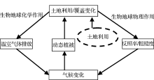
 , 陈海山
, 陈海山

