气候模式中关键陆面植被参量遥感估算的研究进展
陈洪萍1,2, 贾根锁1, 冯锦明1, 董燕生3
1. 中国科学院大气物理研究所东亚区域气候#cod#x02014;环境重点实验室, 北京 100029
2. 中国科学院大学, 北京 100049
3. 北京农业信息技术研究中心, 北京 100097
作者简介:贾根锁(1966-), 男, 内蒙古乌兰察布人, 研究员, 主要从事气候变化, 生态系统能量物质通量, 遥感和陆面过程研究. E-mail:jiong@tea.ac.cn

*通讯作者:陈洪萍(1982-),女,云南玉溪人,博士研究生,主要从事遥感在气候变化中的应用研究. E-mail:chenhp@mail.tea.ac.cn

摘要

卫星遥感资料对于改善气候模式的强迫场, 改进相关物理参数, 提高数值模式模拟的准确性具有重要作用。目前, 全球已经积累了多年的卫星遥感资料, 并且已有多种陆面参量遥感产品。然而, 卫星遥感资料在气候模式中的应用还非常有限。充分利用卫星遥感资料, 对于提高气候模式模拟能力具有重要作用。选择植被覆盖度(Fractional Vegetation Cover, FVC)、叶面积指数(Leaf Area Index, LAI) 和地表反照率(Albedo)3个关键陆面参量的遥感估算方法进行评述, 并分析了陆面参量真实性检验的尺度转换问题, 还以WRF (Weather Research and Forecasting model)为例, 阐述了遥感估算的陆面参量应用于模式的表达方式。最后讨论了关键陆面参量遥感估算的不确定性和遥感参量应用于气候模式的尺度匹配等亟待解决的问题, 并对这些问题的未来改进方向进行了展望。

关键词: 气候模式; 陆面参量; 卫星遥感
中图分类号:P46 文献标志码: 文章编号:1001-8166(2014)01-0056-12
Remote Sensing Estimates of Key Land Surface Vegetation Variables Used in Climate Model: A Review
Chen Hongping1, Jia Gensuo1, Feng Jinming1, Dong Yansheng3
1. Key Laboratory of Regional Climate-Environment Research for Temperate East Asia (RCE-TEA), Chinese Academy of Sciences, Beijing 100029, China
2. University of Chinese Academy of Sciences, Beijing 100049, China
3. National Engineering Research Center for Information Technology in Agriculture, Beijing 100097, China
Abstract

Satellite remote sensing data play an important role in the improvement of climate models forcing field, relevant physical parameters and simulation accuracy. At present, there are many years of satellite remote sensing data and a variety of products about land surface attributes. However, the application of satellite remote sensing data to climate models is still very limited. Fully using satellite remote sensing data is important to improving the simulation ability. In the paper, remote sensing estimates methods of three key land surface parameters including Fractional Vegetation Coverage(FVC), Leaf Area Index(LAI)and surface albedo(Albedo)is reviewed and upor downscaling land surface variables in validation process is analyzed. Secondly, taking WRF(Weather Research and Forecasting)model as an example, three parameters in climate model are described. Finally, the key problems of using remote sensing data in climate models are discussed, which comprise the uncertainties and scales of remote sensing estimation parameters and the future direction is prospected.

Keyword: Climate model; Land surface parameter; Satellite remote sensing.
1 引言

陆面过程是区域和全球气候的重要驱动因素[ 1~ 5]。陆面过程研究对于改进陆面的生态和水文过程理论、陆气相互作用理论、大气边界层物理理论、生态模型、陆面过程模式、数值天气预报模式、气候变化及气候模式, 提高天气、气候预测精度等方面具有重要意义。陆面过程模式主要是为大气模式提供动量、感热、水汽输送等下边界条件, 并以大气模式输出的压、温、湿、风、辐射、降水等作为陆面模式的强迫场。陆面过程模式有众多参量, 包括Albedo、LAI、FVC、冠层属性、粗糙度和土壤含水量等。由于观测资料的缺乏, 确定网格尺度上参量的代表值往往很难。卫星遥感资料为改善数值模式的强迫场, 改进相关物理参数, 评估或提高模式模拟的准确性和精确性提供了强有力的数据支持。EOS(Earth Observing System)和WCRP (World Climate Research Program)研究认为:卫星遥感观测具有提供模式所需输入参数的潜在能力, 卫星遥感产品可能有足够的精度和适用性。EOS系列卫星将能够提供业务化应用的全球表面生物物理特性, 包括植被、陆面覆盖类型、表面反射率等空间分布及其变化图。大多数模式, 如SiB2(Simple Biosphere Model Version 2), CLM (Community Land Model)等都要用到参量。然而, 哪些参量可用遥感资料进行估算, 如何从地物的光谱反射特征中提取地面植被及冠层属性的生物物理参数, 特别是如何应用EOS卫星遥感产品是目前陆面模式研究中的重要问题。

目前, 已经积累了多年的全球卫星遥感资料, 并且已经存在可以用于驱动气候模式的多种陆面参量遥感产品。如卫星遥感LAI产品包括:MODIS(Moderate resolution Imaging SpectroRadiometer)[ 6], MISR (Multi-angle Imaging SpectroRadiometer)[ 7~ 9], MERIS (Medium Resolution Imaging Spectrometer)[ 10~ 12] 等。卫星遥感FVC产品包括:POLDER (Polarization and Directionality of Earth Reflectances)[ 13], CYCLOPES[ 14], MERIS[ 15]等。卫星遥感Albedo产品除MODIS[ 16]以外, 还包括MISR[ 17], POLDER[ 18]等。然而, 大多陆面参量遥感产品开发的初衷并不是专门为气候模式服务, 而且由于受到云的覆盖、大气中的气溶胶、季节性的雪覆盖、传感器故障等因素的影响, 导致现有的遥感参量产品存在着大量的噪音或时空不连续等缺陷[ 19~ 21], 这严重限制了卫星遥感资料在气候模式中的广泛应用。因此, 研究者在使用这些遥感产品之前, 有必要了解这些关键参量的遥感估算方法, 进而对关键陆面参量遥感产品进行有效预处理。

为此, 本研究择LAI、Albedo和FVC 3个关键陆面参量, 分析陆面参量遥感估算的研究进展, 旨在为气候模式使用者提供这些参量生成的参考知识, 以便在使用气候模式过程中更好地利用这些基于卫星遥感资料估算的参量。同时, 本研究以WRF模式为例, 分析遥感估算的关键陆面植被参量应用于气候模式的表达方式, 讨论限制遥感估算的陆面参量应用于气候模式的关键问题及解决思路。

2 气候模式对陆面参量的敏感性

陆面属性, 如植被状态、植被覆盖度、地表反照率等对于气候变化研究尤为重要[ 22~ 25]。气候模式在气候模拟过程中对FVC, LAI和Albedo等陆面参量非常敏感, 如Copeland等[ 26]用模式ClimRAMS(The climate version of Regional Atmospheric Modeling System)评估了模式默认的植被分布与真实自然植被分布对天气和气候的影响, 发现模拟的气象要素的变化与植被参数的变化紧密相关, 特别是对FVC, LAI和Albedo等参量极为敏感。同时, 卫星遥感资料能够有效提高模式模拟的准确性和精确性, 例如Crawford等[ 27]以美国俄克拉何马州为研究区, 利用卫星遥感估算的FVC, LAI和Albedo驱动气候模式MM5(Mesoscale Model 5), 对近地表温度进行模拟, 结果表明模式提高了对1.5 m温度模拟的准确性。

LAI定义为单位地表面积上单面绿叶面积的总和[ 28]。LAI是一个重要的植被结构参数, 因为叶片表面为物质和能量的交换提供了场所, 重要的生物物理过程, 如蒸散发、冠层截留、太阳光的截取、光合作用等都与LAI密切相关。LAI 影响地表和行星边界层之间的能量、物质和动量通量[ 29]。Chase等[ 30]分析了模式GCM(General Circulation Model) 对全球LAI变化的敏感性, 发现在1月和7月, 逐渐减小的LAI降低了地面潜热通量, 增加了感热通量。Lu等[ 31]分别以美国大平原和岩石山区为研究区, 将遥感估算的LAI用于模式ClimRAMS, 结果表明区域气候对植被物候的季节性变化非常敏感, 而且在植被生长季节, 气候模式模拟的结果更为湿润、温度更低。其他类似的GCMs数值试验, 都表明了遥感估算的LAI有助于提高模式模拟结果的准确性[ 32 ~ 37]。Kang等[ 38]分析了卫星遥感估算的LAI对GCM模式季节气候模拟的影响, 指出采用卫星遥感估算的LAI后, 显著地提高了气候模式对东亚、非洲西部夏季季风区和北美温带森林的近地表气候的模拟。同时, 他们的研究认为卫星遥感估算的LAI将净辐射能量分成潜热和感热通量, 将导致气候变暖和降水的减小, 其原因是卫星估算LAI值比气候模式默认值偏小。

Albedo 定义为在整个太阳光谱内, 地表反射的太阳辐射与总的入射太阳辐射之比[ 39]。Albedo表征了地球表面对太阳辐射的反射能力, 广泛应用于地表辐射收支、地表能量平衡的研究。Albedo是一个重要的影响地球气候变化的物理变量, 估量Albedo的变化不仅可以定量化地研究地表和大气之间的能量传递, 而且还可以提高区域和全球气候模拟的准确性。空间和时间上监测Albedo对于全球气候模式的开发非常重要[ 40~ 42], Charney等[ 43]证明了在气候模式中5% Albedo的增加将导致5%~20% 降水的减少。Wang等[ 44]使用MODIS Albedo数据评估模式CCSM2(NCAR Community Climate System Model)计算的地表反照率, 发现模式明显低估了约0.05的地表反照率, 并且在沙漠或一些半干旱地区更为明显。史小康等[ 45]将 MODIS Albedo数据运用到WRF模式, 模拟黄河源区不同下垫面的降水量变化, 表明模式能够更准确地模拟降水量的变化过程。张学珍等[ 46]通过WRF模式分析了MODIS Albedo数据在中国温度模拟中的应用, 结果表明模式能够改进中国东部地区的温度模拟。

FVC定义为植被 (包括叶、茎、枝) 在地面的垂直投影面积占统计区总面积的百分比, 是表征植被水平方向上覆盖程度的一个重要参数。FVC和地表生物圈的众多应用都息息相关, 在地表过程和气候变化、天气预报数值模拟中都需要准确估算FVC[ 47]。FVC也是生态、水文和气候模式中的关键参量。如在WRF模式耦合的Noah 陆面过程模式中, FVC不仅是计算植被冠层截留降水量的关键参数, 而且还控制着LAI的物候期。高艳红等[ 48]将卫星遥感估算的FVC应用到中尺度模式MM5中, 对黑河流域中上流的气候进行数值模拟, 其结果改善了模式对2m 温度的模拟。James等[ 49]使用卫星估算的实时FVC来提高对短期强对流天气的预报。张静辉等[ 50]引入卫星估算的FVC应用到区域气候模式RegCM3(Regional Climate Model Version 3), 对黄河源区主要气候要素进行数值模拟, 结果表明模拟的黄河源区气象台站月平均气温更接近实测值, 改善了局地降水量模拟, 提高近地面感热通量和潜热通量的模拟精度, 且潜热通量的模拟效果比感热通量较好。Kumara等[ 51]将卫星估算的FVC用于WRF模式, 分析其对印度短期天气预报的影响, 结果表明WRF模式提高了24小时内的预报:温度约18%、湿度约10%、降水超过5%。

目前获得的研究结果表明:在气候模拟过程中, 气候模式对FVC, LAI和Albedo等陆面参量非常敏感, 通过卫星遥感资料估算的关键陆面参量能够有效改进气候模式模拟的效果。然而, 上述研究中大多采用植被指数NDVI来估算LAI或FVC, 然后再应用于气候模式的模拟。实际上, 有多种关键陆面参量的遥感估算方法, 并且每种方法都有各自的优缺点。而且, 目前已经生成了多种可以用于驱动气候模式的LAI, FVC和Albedo遥感产品。因此, 了解关键陆面参量的遥感估算方法对于气候模式使用者是非常必要的。以下将对LAI, FVC和Albedo这3种关键陆面参量的遥感估算方法进行分析。

3 遥感估算方法及真实性检验
3.1叶面积指数

通过遥感资料估算LAI的方法可以归纳为4类:经验或半经验模型、物理模型、机器学习、数据同化。

经验或半经验模型是过建立地面实测LAI值与植被指数之间的经验线性或非线性回归模型进行估算。梳理近十年相关文献, 国内外学者们进行了大量相关研究[ 52~ 58], 主要集中在2个方面:①针对不同的卫星遥感数据筛选合适的植被指数, 通常是选择那些既对LAI敏感, 又可以消除土壤背景影响或大气效应影响的植被指数, 其中NDVI (Normalized Vegetation Index)应用最为广泛;②建立最优线性或非线性回归模型, 其中一元回归模型应用最为广泛。

基于物理模型反演LAI的理论基础是认为植被具有非朗伯体特性, 即植被对太阳光短波辐射的散射具有各向异性。物理模型包括:①几何光学模型, 该模型不考虑冠层内的透射作用, 主要用于稀疏林地, 如Li-Strahler几何光学模型[ 59, 60];②辐射传输模型, 该模型重点考虑冠层透射作用, 适合于连续植被冠层的反射状况, 如冠层反射模型SAIL(Scattering by Arbitrarily Inclined leaves)[ 61]、叶光谱属性模型PROSPECT[ 62]等;③几何光学模型和辐射传输模型相结合的混合模型, 即利用几何光学模型在解释阴影投影面积和地物表面空间相关性上的优势, 同时引入辐射传输模型在解释均匀介质中多次散射上的优势, 分2个层次来建立承照面与阴影区反射强度的辐射传输模型。大多数物理模型非常复杂, 如果观测数据不足, 则很难直接得到参量的解析解。因此, 在进行模型反演时, 一般需要建立代价函数, 利用优化算法迭代估算参量。代价函数是物理模型模拟的冠层反射率与遥感影像反射率之间的关系表达。通常采用的策略是联合使用PROSECT和SAIL模型模拟冠层反射率, 采用查找表优化算法[ 52, 58, 63~ 65], 或利用遗传算法优化[ 66], 或者最小二乘法优化逐步迭代方法[ 67], 使得模拟的冠层反射率与遥感影像反射率间尽可能接近, 从而来估算LAI。

LAI遥感估算的机器学习方法主要是通过人工神经网络来实现的, 其关键是确定训练数据。大多用BP神经网络反演LAI, 输入参数为红波段与近红外波段的反射率、太阳天顶角与方位角、观测天顶角[ 14, 15, 68]。在进行神经网络训练时, 通常还会考虑土壤反射的影响[ 66, 69, 70], 并融合多种传感器的反射数据, 联合反演LAI[ 71, 72]

在利用数据同化方法反演LAI时, 大多的策略是利用遥感反射率数据或实测反射率数据, 将LAI作为传递参量, 结合物理模型与构建的LAI预测模型, 最终得到最优的LAI。王东伟等[ 73]以北京昌平和顺义为研究区, 用农作物模型CERES-WHEAT模拟获得LAI, 并将其作为SAIL模型的输入参数, 得到反射值, 然后通过变分的数据同化方法, 同化MODIS 的反射值数据, 使得由SAIL 模型得到的反射值与MODIS反射值最为接近, 进而估算LAI。Xiao等[ 74, 75]则结合物理模型与构建的LAI预测模型, 采用集合卡尔曼滤波等方法来估算LAI。

3.2 地表反照率

Albedo的遥感估算方法归类为2种:经验线性回归模型和物理模型。经验线性回归模型是根据各波段在太阳辐射中所占的权重来估算全波段反照率。Russell等[ 76]建立了AVHRR窄波段反射率与宽波段反射率之间的转换公式。Liang等[ 77]针对不同的传感器, 如MISR, MODIS, POLDER 等, 建立了陆表反射率从窄带到宽带转换的公式。Susaki等[ 78]根据Liang建立的转换公式, 以ASTER数据为例, 分析了Albedo估算时的尺度效应。

目前, 大多数卫星遥感Albedo产品均通过物理模型反演, 并采用多日最大值合成有效去除大部分云的污染。然而, 在热带、极地和山区, 以及在冬季和亚热带雨季, Albedo产品缺失现象仍然非常明显。并且, 由于Albedo遥感产品的时间分辨率低, 现有的Albedo产品不能反映雨雪或者植被快速生长过程中地表反照率的快速变化。此外, 现有的算法未能正确处理冰雪地表, 还忽略地形对Albedo的影响。

3.3 植被覆盖度

FVC的遥感估算方法包括:经验或半经验模型、物理模型、机器学习。利用遥感数据估算FVC的经验或半经验模型类似于LAI的遥感估算[ 79~ 81]

FVC遥感估算的简单物理模型是通过混合像元分解实现的。假设传感器接收到的信号来自植被和非植被的组合, 该方法将遥感影像中的某一像元反射率分解成不同端元(纯像元)反射率的线性组合, 从而在亚像元尺度上估算FVC[ 82~ 84]。线性混合像元分解是最为常用的FVC遥感估算方法, 其关键步骤是确定端元。

FVC遥感估算的机器学习方法类似LAI, 主要是通过人工神经网络来实现的。Boyd等[ 85]比较了通过线性和非线性回归模型, 以及神经网络估算美国太平洋西北部针叶林FVC的精度, 结果表明这两种方法都达到了相同的精度。其他学者也开展了利用人工神经网络估算FVC的类似研究[ 86, 87]

3.4 方法比较

总的来说, 基于经验或半经验模型反演LAI、Albedo和FVC的方法简单易用、计算效率高, 但是需要大量的地面实测参量值和同步观测的遥感数据, 并且建立的经验或半经验关系只适合于特定区域的某种植被类型。基于物理模型反演方法物理意义明确, 但是难以获取辐射传输模型的最优参数。基于神经网络的机器学习方法适用于复杂现象的研究, 但是其物理机制不明确。基于数据同化的反演LAI能够充分利用多种遥感数据的优势来提高反演的精度, 然而该方法计算速度慢、难以满足全球尺度遥感参量产品的生成。LAI, Albedo和FVC的遥感估算方法的比较如表1所示。

3.5 真实性检验

真实性检验是遥感估算参量的重要过程, 如果不知道参量产品的精度, 就不能可靠地使用该参量产品, 因而也就限制了这些参量产品的使用范围。真实性检验方法包括2种:一是不同遥感参量产品的相互比较和误差估计, 常用的评估指标包括空间一致性、时间连续性(是否有数据空隙)、时间一致性(年季变化)等[ 88]。如Fang等[ 89]应用新的三配点误差模型(Triple Collocation Error Model, TCEM)对全球三大LAI产品MODIS、CYCLOPES和GLOBCARBON的理论不确定性进行了分析, 表明

目前3套LAI产品都不能满足全球气候观测系统

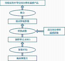
(GCOS)对20%相对精度的要求。二是遥感产品真实性检验的升尺度框架, 这也是最常用的验证方法。该框架是利用地面样点测量值, 采用中间高分影像进行升尺度转换, 来检验遥感参量的估算精度[ 88, 90]图1)。

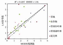
在遥感产品真实性检验的升尺度框架中, 一般采用10~100个地面测量点构成了一个抽样单元 (ESU:Each Sampling Unit), 每一抽样单元的值为该单元内所有地面测量点的均值。再由20~100个抽样单元构成了一个验证样地。需要通过转换函数将抽样单元的值转换为验证样地的值。转换函数通常借用高空间分辨率的遥感影像作为中介, 如25 m×25 m空间分辨率的SPOT, 或者30 m×30 m空间分辨率的TM, ETM等。通过建立中介植被指数与ESU值之间的线性和非线性关系, 生成验证样地影像(Reference Map)用于验证粗分辨率遥感产品, 如MODIS遥感产品。在验证过程中, 关键是确定合适的聚集标准。例如, 某一验证样地像元至少2/3部分被待验证的遥感产品像元所覆盖, 则该验证样地像元为有效验证样地像元。反之, 则为无效验证样地像元。验证遥感产品的精度, 常用的评价指标为均方根误差 (RMSE)、相关系数(R2)、标准差(Std.) 及偏差(B)。图2是利用升尺度框架, 采用44个来自Bigfoot、VALERI站点的全球LAI验证数据评价MODIS-LAI 遥感产品的结果, 结果表明MODIS LAI 产品存在着低估的现象[ 91]

图1 遥感产品真实性检验的升尺度框架Fig.1 The upscale frame of validatingremote sensing products
表1 不同遥感估算方法的比较 Table 1 Comparison of different remote sensing estimation methods
4 WRF模式中关键陆面参量的表达

WRF模式是由美国国家大气研究中心NCAR(National Center for Atmospheric Research)、美国环境预测中心NCEP(National Center for Environmental Prediction)等科研机构联合开发的新一代高分辨率中尺度预报模式和资料同化系统, 作为新一代中尺度模式, 已被证明具备模拟气候的能力, 并广泛应用于气候变化研究, 如NARCCAP(North American Regional Climate Change Assessment Program)[ 92] 。WRF模式分为研究使用和业务应用2种形式, 即ARW (the Advanced Research WRF) 和NMM (the Nonhydrostatic Mesoscale Model)。

目前, WRF模式与多个陆面过程模型耦合, 如最新的WRF3.5版本提供了CLM4、Noah、RUC、SLAB、SSiB、PX等。Noah陆面模式[ 93]是WRF中陆面过程的一种物理方案, 主要输入参数包括土地利用(植被)类型、土壤质地和坡度。陆面模式次要输入参数可以通过3个主要输入参数推算, 例如土地利用(植被)类型决定了LAI, FVC, Albedo等植被特征。2009年4月之前发布的WRF版本使用的是美国地质调查局USGS(United States Geological Survey)提供的 AVHRR(Advanced Very High Resolution Radiometer)土地利用(植被)类型。该数据是利用1992年4月至1993年3月的AVHRR数据, 生成全球1 km×1 km空间分辨率的24类土地利用(植被)类型。在表LANUSE.TBL中, 给定了每种土地利用(植被)类型的夏季/冬季Albedo值。FVC利用1986至1991年的AVHRR NDVI数据得到, 其空间分辨率为0.144º×0.144º, 时间分辨率为月[ 94]。LAI值设定为固定值, 如草地和农田的LAI值为3.22, 灌丛的LAI值为3.02。除了读取静态的陆表参量外, WRF 3.0 版本还可以读取动态的陆表参量。如当usemonalb 选项设置为true时, 将读取来源于WPS geogrid程序的12个Albedo月值;当sst_update选项设置为1时, 将读取12个来源于WPS geogrid程序的MODIS/AVHRR的FVC月值数据。

在2009年4月发布了WRF 3.1 版本, 该版本增加了 Boston 大学提供的基于MODIS数据生成的2001年1月至2001年12月, 全球1 km×1 km空间分辨率的20类土地利用(植被)类型。同时, WRF 3.1 版本还增加了表VEGPARM.TBL。WRF 3.1 版本及之后更新的WRF模式版本, 首先读取LANDUSE.TBL 表中规定的陆面属性参数值。如果VEGPARM.TBL表中有相同的参数, 则这些表中规定的陆面属性参数值将被VEGPARM.TBL表中的值代替。Albedo的计算依赖于土地利用(植被)类型和FVC, 可以通过FVC及其最大值、最小值来计算。Albedo的最大值、最小值在VEGPARM.TBL 表中进行查找。当usemonalb 选项设置为true时, 将读取来源于WPS geogrid程序的12个Albedo月值。LAI值一方面可以通过FVC和VEGPARM.TBL表中给定的其最大值、最小值来计算, 另一方面也可以通过读取外部的数据, 如MODIS LAI遥感数据。当读取外部LAI数据时, 将rdlai2d设置为true, 并将LAI数据格式转换为WPS metgrid.exe 要求的格式。例如, MODIS LAI遥感资料处理外部步骤包括:对MODIS影像进行拼接与裁剪, 使其覆盖整个研究区域;采用单位网格区域平均的方法, 将遥感的分辨率处理到WRF模式水平网格分辨率;对模式网格点上的数据进行插补与修正。内部步骤为:先将处理后的MODIS LAI外部数据写入WPS中, 然后对WRF进行初始化, 并运行WRF。VEGPARM.TBL表中的FVC仍然通过1986~1991年的AVHRR NDVI数据得到, 空间分辨率为0.144º×0.144º, 时间分辨率为月[ 94]。当sst_update选项等于1时, 将读取12个来源于WPS geogrid程序的MODIS/AVHRR的FVC月值数据。

图2 MODIS LAI 遥感产品真实性验证结果Fig.2 The validation result of MODIS LAI product

WRF模式通过耦合新版本的陆面过程模型和增加卫星遥感资料的应用来改进陆面参数化方案。然而, WRF模式应用的两种土地利用资料有待提高, 且时效性不好, 因而作者所在研究小组融合多种土地利用资料进行更新[ 95], 分析土地利用变化对区域气候的影响[ 96]。同时, 作者已经基于最近12年的MODIS-IGBP植被分类和处理后的MODIS-LAI遥感资料, 针对中国区域, 更新了WRF模式VEGPARM.TBL中的LAI最小、最大默认值。如将VEGPARM.TBL中草地的最大、最小值由2.90、0.52更新为1.0959、0.1227;农作物LAI的最大、最小值由VEGPARM.TBL中的5.68、1.56更新为2.5267、0.1805。下一步将对比分析遥感资料引入前后, WRF模拟结果的差异, 以及利用新版本的WRF模式动态读取FVC、LAI、Albedo等遥感资料进行数值模拟实验。

5 讨论与展望
5.1 讨论

将卫星遥感资料估算的陆面参量应用于气候模式需要注意2方面的问题。

第一, 关键陆面参量遥感估算的不确定性问题。在利用遥感资料估算LAI, Albedo和FVC等关键陆面参量时存在不确定性, 包括理论不确定性和物理不确定性两方面[ 97]。理论不确定性是在反演不同陆面参量遥感产品时, 因为输入数据的不确定、反演模型的不完善、以及反演过程的误差传递造成的, 通常用定性的质量指标进行评估[ 14, 98]。理论误差还可以用不确定性评估工具进行量化评估[ 97], , 如三配点误差模型TCEM。物理不确定性则通常采用地面实测值进行量化。Fang等[ 97]通过定量质量指标 (quantitative quality indicators, QQIs) 比较了不同LAI遥感产品的理论误差, 结果表明:①所有的LAI遥感参量产品基本上一致性地表达了LAI的时间变化趋势, 然而常绿阔叶林的LAI存在明显的误差, 主要是因为反射饱和以及云—气溶胶的污染[ 88, 89]; ②对于常绿针叶林, 现有的LAI产品对于冬季的LAI值存在低估的现象[ 88, 89], 主要是因为冬季太阳高度角低、雪和云的污染、以及来自于understory的干扰信号[ 99, 100]。时间序列时空滤波方法可以有效降低遥感参量产品的不确定性, 恢复正确的时间序列, 广泛用于重建时间序列LAI, Albedo遥感产品[ 20, 91, 101~ 103]。然而, 当时间序列遥感数据中缺失值较多时, 则需要充分利用历史遥感资料的先验知识, 分析时间序列遥感产品的时空效应, 以确保能够建立高质量、连续、均一的时间序列关键陆面参量数据集。

第二, 遥感估算的陆面参量应用于气候模式的尺度匹配问题。将遥感估算的陆面参量应用于气候模式时, 应该选择合适的空间分辨率。例如, 在不同空间分辨率情况下, 遥感估算的LAI相对一致[ 104]。然而, 当遥感数据的空间分辨率较粗时, Albedo变化较大[ 105], 这主要取决于太阳高度角、卫星的传感器、影像获取的时间、瞬间视场内土壤类型、土壤湿度、地形起伏等。

同时, 因为FVC, LAI, Albedo均依赖于土地利用(植被)类型, 如果这3个参量不是从外部数据直接读取, 可以先根据研究区的现有卫星遥感数据, 更新土地利用(植被)类型。需要注意的是:由于卫星遥感陆面参量的定义可能与气候模式中不同陆面过程参量的定义存在差异, 因此在将卫星遥感估算的陆面参量应用于气候模式的过程中, 需要谨慎处理。

5.2 展望

全球已经积累了近30年的卫星观测资料, 为理解与防范全球环境变化风险提供了关键性测量结果。降低关键陆面参量遥感估算不确定性和分析陆面参量应用于气候模式的尺度效应, 从卫星遥感资料中获取准确的关键陆面参量, 将会有效提高气候模式的模拟能力。

全球地球观测系统发展迅速, 显著增强了全球资源环境监测能力, 可利用的卫星遥感资料将越来越多。融合多源卫星遥感资料, 建立陆面参量校验的统一理论框架是降低关键陆面参量遥感估算不确定性的有效途径。其基本思路是:在充分理解目前各种参量产品的遥感估算方法的基础上, 利用地面标准化验证数据对遥感产品的不确定性进行量化、并且分析时间序列遥感产品的时空效应, 充分利用历史卫星遥感资料的先验知识, 基于数据同化的策略对时间序列的遥感产品进行重建, 生成时空连续的高质量、连续、均一的遥感数据集。在真实性检验方面, 科学界正在努力建立一套完整的、连续观测的、覆盖多种典型植物类型的标准化验证数据。如NASA, ESA等国际机构在全球开展了多个验证遥感参数产品的地面验证项目, 如FIFE, BOREAS, PROVE等。国内学者也在顺义、黑河等地开展了大型观测实验, 并且全球地面物候观测网、碳通量站点和传感器网络的不断完善。以此为契机, 应尽早开展针对气候模式应用的关键陆面参量时间序列重建和校验的科学研究及应用。

随着全球对卫星地观测能力、数值预报模式分辨率和高性能计算机能力的极大提高, 特别是针对卫星遥感资料的数据同化技术的不断完善。不难想象, 气候模式的数值天气预报精度将会显著提高。这需要全球科学家有效的合作研究, 从地物的光谱反射特征中提取地面植被及冠层属性的生物物理参数, 开发适用于气候模式的LAI, Albedo和FVC等关键陆面参量数据集。同时, 需要进一步利用包括被动和主动微波遥感, 如SSM/I, AMSR, 各种SAR等反演的土壤含水量、积雪等参数等。

在成文过程中, 参考了2010—2012年北京大学《定量遥感》研究生精品课程班, 北京师范大学第1和第2届《陆表卫星遥感数据反演理论与方法暑期讲习班》部分老师的相关讲义, 这些老师分别是郭华东、刘树华、柳钦火、刘强、肖志强、阎广建。在此一并致谢。

The authors have declared that no competing interests exist.

参考文献
[1] Dickinson R E, Henderson-Sellers A. Modeling tropical deforestation: A study of GCM land -surface parameterizations[J]. Quarterly Journal of Royal Meteorological Society, 1998, 114: 439-462. [本文引用:1] [JCR: 3.327]
[2] Xue Y, Shukla J. The influence of land surface properties on Sahel climate. Part I: Desertification[J]. Journal of Climate, 1993, 6: 2 232-2 245. [本文引用:1] [JCR: 4.362]
[3] Betts A K, Ball J H, Beljaars A C M, et al. The land surface-atmosphere interaction: A review based on observational and global modeling perspectives[J]. Journal of Geophysical Research, 1996, 101: 7 209-7 225. [本文引用:1]
[4] Xue Y, Juang H M H, Li W, et al. Role of land surface processes in monsoon development: East Asia and West Africa[J]. Journal of Geophysical Research, 2004, 109: D03105, doi: 10.1029/2003JD003556. [本文引用:1]
[5] Xue Y, Sales F De, Li W, et al. Role of land surface processes in South American monsoon development[J]. Journal of Climate, 2006, 19: 741-762. [本文引用:1] [JCR: 4.362]
[6] Knyazikhin Y, Martonchik J V, Myneni R B, et al. Synergistic algorithm for estimating vegetation canopy leaf area index and fraction of absorbed photosynthetically active radiation from MODIS and MISR data[J]. Journal of Geophysical Research, 1998, 103: 32 257-32 274. [本文引用:1]
[7] Knyazikhin Y, Martonchik J V, Diner D J, et al. Estimation of vegetation canopy leaf area index and fraction of absorbed photosynthetically active radiation from atmosphere-corrected MISR data[J]. Journal of Geophysical Research, 1998, 103: 32 239-32 256. [本文引用:1]
[8] Hu J, Tan B, Shabanov N, et al. Performance of the MISR LAI and FPAR algorithm: A case study in Africa[J]. Remote Sensing of Environment, 2003, 88: 324-340. [本文引用:1] [JCR: 5.103]
[9] Hu J, Su Y, Tan B, et al. Analysis of the MISR LAI/FPAR product for spatial and temporal coverage, accuracy and consistency[J]. Remote Sensing of Environment, 2007, 107: 334-347. [本文引用:1] [JCR: 5.103]
[10] Gobron N, Pinty B, Verstraete M M, et al. Advanced vegetation indices optimized for up-coming sensors: Design, performance and applications[J]. IEEE Transactions on Geoscience and Remote Sensing, 2000, 38: 2 489-2 505. [本文引用:1] [JCR: 3.467]
[11] Gobron N, Pinty B, Aussedat O, et al. Evaluation of fraction of absorbed photosynthetically active radiation products for different canopy radiation transfer regimes: Methodology and results using Joint Research Center products derived from SeaWiFS against ground-based estimations[J]. Journal of Geophysical Research, 2006, 111: D13110, doi: 12.1029/2005JD006511. [本文引用:1]
[12] Gobron N, Pinty B, Aussedat O, et al. Uncertainty estimates for the FAPAR operational products derived from MERIS—Impact of top-of-atmosphere radiance uncertainties and validation with field data[J]. Remote Sensing of Environment, 2008, 112: 1 871-1 883, doi: 10.1016/j.rse.2007.09.011. [本文引用:1] [JCR: 5.103]
[13] Roujean J L, Lacaze R. Global mapping of vegetation parameters from POLDER multiangular measurements for studies of surface-atmosphere interactions: A pragmatic method and its validation[J]. Journal of Geophysical Research, 2002, 107: 10 129-10 145. [本文引用:1]
[14] Baret F, Hagolle O, Geiger B, et al. LAI, fAPAR and fCover CYCLOPES global products derived from VEGETATION. Part 1: Principles of the algorithm[J]. Remote Sensing of Environment, 2007, 110: 275-286. [本文引用:3] [JCR: 5.103]
[15] Bacour C, Baret F, Beal D, et al. Neural network estimation of LAI, fAPAR, fCover and LAI×Cab, from top of canopy MERIS reflectance data: Principles and validation[J]. Remote Sensing of Environment, 2006, 105: 313-325. [本文引用:2] [JCR: 5.103]
[16] Schaaf C, Gao F, Strahler A H, et al. First operational BRDF, albedo nadir reflectance products from MODIS[J]. Remote Sensing of Environment, 2002, 83: 135-148. [本文引用:1] [JCR: 5.103]
[17] Martonchik J, Pinty B, Verstraete M. Note on an improved model of surface BRDF-atmospheric coupled radiation[J]. IEEE Transactions on Geoscience and Remote Sensing, 2002, 40: 1 637-1 639. [本文引用:1] [JCR: 3.467]
[18] Bacour C, Bréon F. Variability of land surface BRDFs[J]. Remote Sensing of Environment, 2005, 98: 80-95. [本文引用:1] [JCR: 5.103]
[19] Lawrence P J, Chase T N. Representing a new MODIS consistent land surface in the Community Land Model (CLM 3. 0)[J]. Journal of Geophysical Research, 2007, 112: G01023, doi: 10.1029/2006JG000168. [本文引用:1]
[20] Fang H, Liang S, Townshend J, et al. Spatially and temporally continuous LAI data sets based on a new filtering method: Examples from North America[J]. Remote Sensing of Environment, 2008, 112: 623-635. [本文引用:1] [JCR: 5.103]
[21] Borak J S, Jasinski M F. Effective interpolation of incomplete satellite derived leaf-area index time series for the continental United States[J]. Agricultural and Forest Meteorology, 2009, 149: 320-332. [本文引用:1] [JCR: 3.421]
[22] Fu C. Potential impacts of human-induced land cover change on East Asia monsoon[J]. Global and Planetary Change, 2003, 37(3/4): 219-229. [本文引用:1] [JCR: 3.155]
[23] Foley J, DeFries R, Asner G, et al. Global consequences of land use[J]. Science, 2005, 309: 570-574. [本文引用:1]
[24] Bonan G. Forests and climate change: Forcings, feedbacks, and the climate benefits of forests[J]. Science, 2008, 320: 1 444-1 449. [本文引用:1]
[25] Mahmood R, Pielke R, Hubbard K, et al. Impacts of land use/land cover change on climate and future research priorities[J]. Bulletin of the American Meteorological Society, 2010, 91: 37-46. [本文引用:1] [JCR: 6.591]
[26] Copeland J H, Pielke R A, Kittel T G F. Potential climatic impacts of vegetation change: A regional modeling study[J]. Journal of Geophysical Research, 1996, 101: 7 409-7 418. [本文引用:1]
[27] Crawford T M, Stensrud D J, Mora F, et al. Value of incorporating satellite-derived land cover data in mm5/place for simulating surface temperatures[J]. Journal of Hydrometeorology, 2001, 2: 453-468. [本文引用:1] [JCR: 3.273]
[28] Chen J M, Black T A. Defining leaf area index for non-flat leaves[J]. Plant, Cell and Environment, 1992, 15: 421-429. [本文引用:1] [JCR: 5.135]
[29] Justice C O, Vermote E, Townshend J R, et al. The Moderate Resolution Imaging Spectroradiometer (MODIS): Land remote sensing for global change research[J]. IEEE Transactions on Geoscience and Remote Sensing, 1998, 36(4): 1 228-1 249. [本文引用:1] [JCR: 3.467]
[30] Chase T N, Pielke R A, Kittel T G F, et al. Sensitivity of a general circulation model to global changes in leaf area index[J]. Journal of Geophysical Research, 1996, 101: 7 393-7 408. [本文引用:1]
[31] Lu L, Shuttleworth W J. Incorporating NDVI-derived LAI into the climate version of RAMS and its impact on regional climate[J]. Journal of Hydrometeorology, 2002, 3: 347-362. [本文引用:1] [JCR: 3.273]
[32] Bounoua L, Collatz G J, Los S O, et al. Sensitivity of climate to changes in NDVI[J]. Journal of Climate, 2000, 13: 2 277-2 292. [本文引用:1] [JCR: 4.362]
[33] Buermann W, Dong J, Zeng X, et al. Evaluation of the utility of satellite-based leaf area index data for climate simulation[J]. Journal of Climate, 2001, 14: 3 536-3 550. [本文引用:1] [JCR: 4.362]
[34] Guillevic P, Koster R D, Suarez M J, et al. Influence of the interannual variability of vegetation on the surface energy balance—A global sensitivity study[J]. Journal of Hydrometeorology, 2002, 3: 617-629. [本文引用:1] [JCR: 3.273]
[35] Van den Hurk B J, Viterbo P, Los S O. Impact of leaf area index seasonality on the annual land surface evaporation in a general circulation model[J]. Journal of Geophysical Research, 2003, 108: 4 191. [本文引用:1]
[36] Tian Y, Dickinson R E, Zhou L, et al. Land boundary conditions from MODIS data and consequences for the albedo of a climate model[J]. Geophysical Research Letters, 2004, 31: L05504, doi: 10.1029/2003GL019104. [本文引用:1] [JCR: 3.982]
[37] Tian Y, Dickinson R E, Zhou L, et al. Impact of new land boundary conditions from Moderate Resolution Imaging Spectroradiometer (MODIS) data on the climatology of land surface variables[J]. Journal of Geophysical Research, 2004, 109: D20115, doi: 10.1029/2003JD004499. [本文引用:1]
[38] Kang H S, Xue Y K, Collatz G J. Impact assessment of satellite-derived leaf area index datasets using a general circulation model[J]. Journal of Climate, 2007, 20: 993-1 015. [本文引用:1] [JCR: 4.362]
[39] Dickinson R E. Land surface processes and climate surface albedos and energy balance[J]. Advances in Geophysics, 1983, 25: 305-303. [本文引用:1] [JCR: 3.333]
[40] Frida A-M B, Henning R, Robert J C, et al. 22 views of the global albedo—Comparison between 20 GCMs and two satellites[J]. Tellus A, 2006, 58: 320-330. [本文引用:1]
[41] Alton P. A simple retrieval of ground albedo and vegetation absorptance from MODIS satellite data for parameterisation of global land -surface models[J]. Agricultural and Forest Meteorology, 2009, 149: 1 769-1 775. [本文引用:1] [JCR: 3.421]
[42] Hollinger D Y, Ollinger S V, Richardson A D, et al. Albedo estimates for land surface models and support for a new paradigm based on foliage nitrogen concentration[J]. Global Change Biology, 2009, 16: 696-710. [本文引用:1] [JCR: 6.91]
[43] Charney J G, Quirk W J, Chow S H, et al. A comparative study of the effects of albedo change on drought in semi-arid regions[J]. Journal of Atmospheric Science, 1977, 34: 1 366-1 385. [本文引用:1]
[44] Wang Z, Zeng X, Barlage M, et al. Using MODIS BRDF and albedo data to evaluate global model land surface albedo[J]. Journal of Hydrometeorology, 2004, 5(1): 3-14. [本文引用:1] [JCR: 3.273]
[45] Shi Xiaokang, Wen Jun, Tian Hui, et al. Application of MODIS albedo data in the simulation of land surface and rainfall processes over the Yellow River water source region[J]. Chinese Journal of Atmospheric Sciences, 2009, 33(6): 1 187-1 200.
[史小康, 文军, 田辉, . MODIS 反照率产品在模拟黄河源区陆面过程和降水中的应用[J]. 大气科学, 2009, 33(6): 1 187-1 200. ] [本文引用:1] [CJCR: 1.948]
[46] Zhang Xuezhen, Zheng Jingyun, He Fanneng, et al. Application of MODIS BRDF/Albedo dataset in the regional temperature simulation of China[J]. Acta Geographica Sinca, 2011, 66(3): 356-366.
[张学珍, 郑景云, 何凡能, . MODIS BRDF/Albedo 数据在中国温度模拟中的应用[J]. 地理学报, 2011, 66(3): 356-366. ] [本文引用:1] [CJCR: 2.937]
[47] Zeng X B, Dickinson R E, Walker A, et al. Derivation and evaluation of global 1-km fractional vegetation cover data for land modeling[J]. Journal of Applied Meteorology, 2000, 39: 826-839. [本文引用:1] [JCR: 1.702]
[48] Gao Yanhong, Liu Wei, Ran Youhua, et al. Vegetation coverage fraction calculation and the mesoscale modeling in Heihe River Basin[J]. Plateau Meteorology, 2007, 26(2): 270-277.
[高艳红, 刘伟, 冉有华, . 黑河流域植被覆盖度计算及其影响的中尺度模拟[J]. 高原气象, 2007, 26(2): 270-277. ] [本文引用:1] [CJCR: 1.688]
[49] James K A, Stensrud D J, Yossouf N. Value of real-time vegetation fraction to forecasts of severe convection in high-resolution models[J]. Weather Forecast, 2009, 24: 187-210. [本文引用:1] [JCR: 1.86]
[50] Zhang Jinghui, Wen Jun, Zhang Tangtang, et al. Numerical simulation of influence of fractional vegetation cover change in the source water region of Yellow River on regional climate[J]. Plateau Meteorology, 2011, 30(4): 989-995.
[张静辉, 文军, 张堂堂, . 黄河源区植被覆盖度对区域气候影响的数值模拟[J]. 高原气象, 2011, 30(4): 989-995. ] [本文引用:1] [CJCR: 1.688]
[51] Kumara P, Bhattacharyab B K, Pala P K. Impact of vegetation fraction from Indian geostationary satellite on short-range weather forecast[J]. Agricultural and Forest Meteorology, 2013, 168: 82-92. [本文引用:1] [JCR: 3.421]
[52] Qi L, Kerr Y, Moran M, et al. Leaf area index estimates using remotely sensed data and BRDF models in a semiarid region[J]. Remote Sensing of Environment, 2000, 73: 18-30. [本文引用:2] [JCR: 5.103]
[53] Xiao X, He L, Salas W, et al. Quantitative relationships between field-measured leaf area index and vegetation index derived from VEGETATION images for paddy rice fields[J]. International Journal of Remote Sensing, 2002, 23(18): 3 595-3 604. [本文引用:1]
[54] Colombo R, Bellingeri D, Fasolini D, et al. Retrieval of leaf area index in different vegetation types using high resolution satellite data[J]. Remote Sensing of Environment, 2003, 86: 120-131. [本文引用:1] [JCR: 5.103]
[55] Anderson A, Neale C, Li F, et al. Upscaling ground observations of vegetation water content, canopy height, and leaf area index during SMEX02 using aircraft and Land sat imagery[J]. Remote Sensing of Environment, 2004, 92: 447-464. [本文引用:1] [JCR: 5.103]
[56] Tan B, Hu J, Zhang P, et al. Validation of moderate resolution imaging spectroradiometer leaf area index product in cropland s of Alpilles, France[J]. Journal of Geophysical Research, 2005, 110: D01107, doi: 10.1029/2004JD004860. [本文引用:1]
[57] Delalicux S, Somers B, Hereijgers S, et al. A near-infrared narrow-waveband ratio to determine leaf area index in orchards[J]. Remote Sensing of Environment, 2008, 112: 3 762-3 772. [本文引用:1] [JCR: 5.103]
[58] Maire G, Marsden C, Verhoef W, et al. Leaf area index estimation with MODIS reflectance time series and model inversion during full rotations of Eucalyptus plantations[J]. Remote Sensing of Environment, 2011, 115: 586-599. [本文引用:2] [JCR: 5.103]
[59] Li X, Strahler A. Geometric-optical bidirectional reflectance modeling of a conifer forest canopy[J]. IEEE Transaction on Geoscience and Remote Sensing, 1986, 24: 906-919. [本文引用:1] [JCR: 3.467]
[60] Li X, Strahler A. Geometric-optical bidirectional reflectance modeling of the discrete crown vegetation canopy: Effect of grown shape and mutual shadowing[J]. IEEE Transaction on Geoscience and Remote Sensing, 1992, 30(2): 276-292. [本文引用:1] [JCR: 3.467]
[61] Verhoef W. Light scattering by leaf layers with application to canopy reflectance modeling, the SAIL model[J]. Remote Sensing of Environment, 1984, 16: 125-141. [本文引用:1] [JCR: 5.103]
[62] Jacquemoud S, Baret F. PROSPECT: A model of leaf optical properties[J]. Remote Sensing of Environment, 1990, 34: 75-91. [本文引用:1] [JCR: 5.103]
[63] Yang W, Huang D, Tan B, et al. Analysis of leaf area index and fraction of PAR absorbed by vegetation products from the terra MODIS sensor: 2000-2005[J]. IEEE Transactions on Geoscience and Remote Sensing, 2006, 44(7): 1 829-1 842. [本文引用:1] [JCR: 3.467]
[64] Houborg R, Boegh E. Mapping leaf chlorophyll and leaf area index using inverse and forward canopy reflectance modeling and SPOT reflectance data[J]. Remote Sensing of Environment, 2008, 112: 186-202. [本文引用:1] [JCR: 5.103]
[65] Ganguly S, Nemani R, Zhang G, et al. Generating global leaf area index from land sat: Algorithm formulation and demonstration[J]. Remote Sensing of Environment, 2012, 122: 185-202. [本文引用:1] [JCR: 5.103]
[66] Fang H, Liang S, Kuusk A. Retrieving leaf area index using a genetic algorithm with a canopy radiative transfer model[J]. Remote Sensing of Environment, 2003, 85: 257-270. [本文引用:2] [JCR: 5.103]
[67] Moroni M, Colombo R, Panigada C. Inversion of a radiative transfer model with hyperspectral observations for LAI mapping in poplar plantations[J]. Remote Sensing of Environment, 2004, 92: 195-206. [本文引用:1] [JCR: 5.103]
[68] Danson F M, Rowland C S, Baret F. Training a neural network with a canopy reflectance model to estimate crop leaf area index[J]. International Journal of Remote Sensing, 2003, 24(3): 4 891-4 905. [本文引用:1]
[69] Fang H, Liang S. A hybrid inversion method for mapping leaf area index from MODIS data: Experiments and application to broadleaf and needleleaf canopies[J]. Remote Sensing of Environment, 2005, 94: 405-424. [本文引用:1] [JCR: 5.103]
[70] Walthall C, Dulaney W, Anderson M, et al. A comparison of empirical and neural network approaches for estimating corn and soybean leaf area index from Land sat ETM+ imagery[J]. Remote sensing of Environment, 2004, 92: 465-474. [本文引用:1] [JCR: 5.103]
[71] Verger A, Baret F, Weiss M. Performances of neural networks for deriving LAI estimates from existing CYCLOPES and MODIS products[J]. Remote Sensing of Environment, 2008, 112: 2 789-2 803. [本文引用:1] [JCR: 5.103]
[72] Verger A, Baret F, Weiss M. A multisensor fusion approach to improve LAI time series[J]. Remote Sensing of Environment, 2011, 115(10): 2 460-2 470. [本文引用:1] [JCR: 5.103]
[73] Wang Dongwei, Wang Jindi, Liang Shunlin. Retrieving crop leaf area index by assimilation of MODIS data into crop growth model[J]. Science in China (Series D), 2010, 40(1): 73-83.
[王东伟, 王锦地, 梁顺林. 作物生长模型同化MODIS反射率方法提取作物叶面积指数[J]. 中国科学: D辑, 2010, 40(1): 73-83. ] [本文引用:1]
[74] Xiao Z, Liang S, Wang J, et al. A temporally integrated inversion method for estimating leaf area index from MODIS data[J]. IEEE Transactions on Geoscience and Remote Sensing, 2009, 47(8): 2 536-2 535. [本文引用:1] [JCR: 3.467]
[75] Xiao Z, Liang S, Wang J, et al. Real-time retrieval of leaf area index from MODIS time series data[J]. Remote Sensing of Environment, 2011, 115: 97-106. [本文引用:1] [JCR: 5.103]
[76] Russell M J, Nunez M, Chladil M A, et al. Conversion of nadir, narrow-band reflectance in red and near-infrared channels to hemispherical surface albedo[J]. Remote Sensing of Environment, 1997, 61: 16-23. [本文引用:1] [JCR: 5.103]
[77] Liang S, Shuey C, Russ A. Narrowband to broadband conversions of land surface albedo: II. Validation[J]. Remote Sensing of Environment, 2002, 84: 25-41. [本文引用:1] [JCR: 5.103]
[78] Susaki J, Yasuoka Y, Kajiwara K, et al. Validation of MODIS albedo products of paddy fields in Japan[J]. IEEE Transactions on Geoscience and Remote Sensing, 2007, 45: 206-217. [本文引用:1] [JCR: 3.467]
[79] Jakubauskas M, Kindscher K, Fraser A, et al. Close-range remote sensing of aquatic macrophyte vegetation cover[J]. International Journal of Remote Sensing, 2000, 21(18): 3 533-3 538. [本文引用:1]
[80] Gitelson A A, Kaufman Y J, Stark R, et al. Novel algorithms for remote estimation of vegetation fraction[J]. Remote Sensing of Environment, 2002, 80: 76-87. [本文引用:1] [JCR: 5.103]
[81] Patel N K, Saxena R K, Shiwalkar A J. Study of fractional vegetation cover using high spectral resolution data[J]. Journal of Indian Society Remote Sensing, 2007, 35(1): 73-79. [本文引用:1] [JCR: 0.344]
[82] Theseira M A, Thomas G, Sannier C A D. An evaluation of spectral mixture modeling applied to a semi-arid environment[J]. International Journal of Remote Sensing, 2002, 23: 687-700. [本文引用:1]
[83] Okin G S. Relative spectral mixture analysis—A multitemporal index of total vegetation cover[J]. Remote Sensing of Environment, 2007, 106: 467-479. [本文引用:1] [JCR: 5.103]
[84] Guerschman J P, Hill M J, Renzullo L J, et al. Estimating fractional cover of photosynthetic vegetation, nonphotosynthetic vegetation and bare soil in the Australian tropical savanna region upscaling the EO-1 Hyperion and MODIS sensors[J]. Remote Sensing of Environment, 2009, 113: 928-945. [本文引用:1] [JCR: 5.103]
[85] Boyd D S, Foody G M, Ripple W J. Evaluation of approaches for forest cover estimation in the Pacific Northwest, USA, using remote sensing[J]. Applied Geography, 2002, 22: 375-392. [本文引用:1]
[86] Van de Voorde T, Vlaeminck J, Canters F. Comparing different approaches for mapping urban vegetation cover from land sat ETM+ data: A case study on Brussels[J]. Sensors, 2008, 8: 3 880-3 902. [本文引用:1] [JCR: 1.953]
[87] Jiapaer G, Chen X, Bao A. A comparison of methods for estimating fractional vegetation cover in arid regions[J]. Agricultural and Forest Meteorology, 2011, 151: 1 698-1 710. [本文引用:1] [JCR: 3.421]
[88] Garrigues S, Lacaze R, Baret F, et al. Validation and intercomparison of global leaf area index products derived from remote sensing data[J]. Journal of Geophysical Research, 2008, 113: G02028, doi: 10.1029/2007JG000635. [本文引用:4]
[89] Fang H, Wei S, Jiang C, et al. Theoretical uncertainty analysis of global MODIS, CYCLOPES and GLOBCARBON LAI products using a triple collocation method[J]. Remote Sensing of Environment, 2012, 124: 610-621. [本文引用:3] [JCR: 5.103]
[90] Morisette J, Baret F, Privette J L, et al. Validation of global moderate resolution LAI products: A framework proposed within the CEOS land product validation subgroup[J]. IEEE Transactions on Geoscience and Remote Sensing, 2006, 44: 1 804-1 817. [本文引用:1] [JCR: 3.467]
[91] Yuan H, Dai Y, Xiao Z, et al. Reprocessing the MODIS leaf area index products for land surface and climate modeling[J]. Remote Sensing of Environment, 2011, 115: 1 171-1 187. [本文引用:2] [JCR: 5.103]
[92] Leung L R, Qian Y. Atmospheric rivers induced heavy precipitation and flooding in the western U. S. Simulated by the WRF regional climate model[J]. Geophysical Research Letters, 2009, 36: L03820, doi: 10.1029/2008GL036445. [本文引用:1] [JCR: 3.982]
[93] Chen F, Dudhia J. Coupling an advanced land -surface/hydrology model with the Penn State/NCAR MM5 modeling system. Part II: Model validation[J]. Monthly Weather Review, 2001, 129: 587-604. [本文引用:1] [JCR: 2.758]
[94] Gutman G, Ignatov A. The derivation of the green vegetation fraction from NOAA/AVHRR data for use in numerical weather prediction models[J]. International Journal of Remote Sensing, 1998, 19(8): 1 533-1 543. [本文引用:2]
[95] Gao H, Jia G. Assessing disagreement and tolerance of misclassification of satellite-derived land cover products used in WRF model applications[J]. Advances in Atmospheric Sciences, 2013, 35(1): 125-141. [本文引用:1] [JCR: 1.338] [CJCR: 0.9244]
[96] Jun W, Feng J, Yan Z, et al. Nested high-resolution modeling of the impact of urbanization on regional climate in three vast urban agglomerations in China[J]. Journal of Geophysical Research, 2012, 117: D21103, doi: 10.1029/2012JD018226. [本文引用:1]
[97] Fang H, Jiang C, Li W, et al. Characterization and intercomparison of global moderate resolution Leaf Area Index (LAI) products: Analysis of climatologies and theoretical uncertainties[J]. Journal of Geophysical Research Biogeoscience, 2013, 118: 1-20. [本文引用:3] [JCR: 3.174]
[98] Pinty B, Andredakis M, Clerici T, et al. Exploiting the MODIS albedos with the Two-stream Inversion Package (JRC-TIP): 1. Effective leaf area index, vegetation, and soil properties[J]. Journal of Geophysical Research, 2011, 116: D09105, doi: 10.1029/2010JD015372. [本文引用:1]
[99] Pisek J, Chen M, Alikas K, et al. Impacts of including forest understory brightness and foliage clumping information from multiangular measurements on leaf area index mapping over North American[J]. Journal of Geophysical Research, 2010, 115: G03023, doi: 10.1029/2009JG001138. [本文引用:1]
100 Weiss M, Baret M, Garrigues S, et al. LAI and fPAR CYCLOPES global products derived from VEGETATION. Part 2: Validation and comparison with MODIS collection 4 products[J]. Remote Sensing Environment, 2007, 110(3): 317-331. [本文引用:1] [JCR: 5.103]
101 Moody E, King M, Platnick S, et al. Spatially complete global spectral surface Albedos: Value-added datasets derived from terra MODIS land products[J]. IEEE Transactions on Geoscience and Remote Sensing, 2005, 43(1): 144-158. [本文引用:1] [JCR: 3.467]
102 Fang H, Liang S, Kim H, et al. Developing a spatially continuous 1 km surface albedo data set over North America from terra MODIS products[J]. Journal of Geophysical Research, 2007, 112: D20206, doi: 10.1029/2006JD008377. [本文引用:1]
103 Parajka J, Bloschl G. Spatio-temporal combination of MODIS images-potential for snow cover mapping[J]. Water Resources Research, 2008, 44(3), doi: 10.1029/2007WR006204. [本文引用:1] [JCR: 3.149]
104 Zheng G, Moskal L M. Retrieving Leaf Area Index (LAI) using remote sensing: Theories, methods and sensors[J]. Sensors, 2009, 9(4): 2 719-2 745. [本文引用:1] [JCR: 1.953]
105 Liu Huizhi, Tu Gang, Dong Wenjie. Three-year changes of surface albedo of degraded grassland and cropland surfaces in a semiarid area[J]. Chinese Science Bulletin, 2008, 53(8): 1 246-1 254. [本文引用:1] [JCR: 1.319] [CJCR: 0.95]
106 Li Xin, Liu Shaomin, Ma Mingguo, et al. HiWATER: An integrated remote sensing experiment on hydrological and ecological processes in the Heihe River Basin[J]. Advances in Earth Science, 2012, 27(5): 481-498, doi: 1011867/j. issn. 1001-8166. 2012. 05. 0481.
[李新, 刘绍民, 马明国, . 黑河流域生态—水文过程综合遥感观测联合试验总体设计[J]. 地球科学进展, 2012, 27(5): 481-498, doi: 10.11867/j.issn.1001-8166.2012.05.0481. ] [本文引用:1] [CJCR: 1.388]
107 Feng Qi, Su Yonghong, Si Jianhua, et al. Ecohydrological transect survey of Heihe River Basin[J]. Advances in Earth Science, 2013, 28(2): 187-196, doi: 10. 11867/j. issn. 1001-8166. 2013. 02. 0187.
[冯起, 苏永红, 司建华, . 黑河流域生态水文样带调查[J]. 地球科学进展, 2013, 28(2): 187-196, doi: 10.11867/j.issn.1001-8166.2013.02.0187. ] [本文引用:1] [CJCR: 1.388]